CN100555311C - Pattern recognition device and image-recognizing method - Google Patents
Pattern recognition device and image-recognizing method Download PDFInfo
- Publication number
- CN100555311C CN100555311C CNB2006100069534A CN200610006953A CN100555311C CN 100555311 C CN100555311 C CN 100555311C CN B2006100069534 A CNB2006100069534 A CN B2006100069534A CN 200610006953 A CN200610006953 A CN 200610006953A CN 100555311 C CN100555311 C CN 100555311C
- Authority
- CN
- China
- Prior art keywords
- mentioned
- image
- information
- image information
- roadway characteristic
- Prior art date
- Legal status (The legal status is an assumption and is not a legal conclusion. Google has not performed a legal analysis and makes no representation as to the accuracy of the status listed.)
- Expired - Fee Related
Links
Images


Classifications
-
- G—PHYSICS
- G06—COMPUTING; CALCULATING OR COUNTING
- G06T—IMAGE DATA PROCESSING OR GENERATION, IN GENERAL
- G06T17/00—Three dimensional [3D] modelling, e.g. data description of 3D objects
- G06T17/05—Geographic models
-
- G—PHYSICS
- G06—COMPUTING; CALCULATING OR COUNTING
- G06V—IMAGE OR VIDEO RECOGNITION OR UNDERSTANDING
- G06V20/00—Scenes; Scene-specific elements
- G06V20/50—Context or environment of the image
- G06V20/56—Context or environment of the image exterior to a vehicle by using sensors mounted on the vehicle
- G06V20/588—Recognition of the road, e.g. of lane markings; Recognition of the vehicle driving pattern in relation to the road
-
- B—PERFORMING OPERATIONS; TRANSPORTING
- B60—VEHICLES IN GENERAL
- B60W—CONJOINT CONTROL OF VEHICLE SUB-UNITS OF DIFFERENT TYPE OR DIFFERENT FUNCTION; CONTROL SYSTEMS SPECIALLY ADAPTED FOR HYBRID VEHICLES; ROAD VEHICLE DRIVE CONTROL SYSTEMS FOR PURPOSES NOT RELATED TO THE CONTROL OF A PARTICULAR SUB-UNIT
- B60W2420/00—Indexing codes relating to the type of sensors based on the principle of their operation
- B60W2420/40—Photo or light sensitive means, e.g. infrared sensors
- B60W2420/403—Image sensing, e.g. optical camera
-
- B—PERFORMING OPERATIONS; TRANSPORTING
- B60—VEHICLES IN GENERAL
- B60W—CONJOINT CONTROL OF VEHICLE SUB-UNITS OF DIFFERENT TYPE OR DIFFERENT FUNCTION; CONTROL SYSTEMS SPECIALLY ADAPTED FOR HYBRID VEHICLES; ROAD VEHICLE DRIVE CONTROL SYSTEMS FOR PURPOSES NOT RELATED TO THE CONTROL OF A PARTICULAR SUB-UNIT
- B60W2552/00—Input parameters relating to infrastructure
- B60W2552/05—Type of road
-
- B—PERFORMING OPERATIONS; TRANSPORTING
- B60—VEHICLES IN GENERAL
- B60W—CONJOINT CONTROL OF VEHICLE SUB-UNITS OF DIFFERENT TYPE OR DIFFERENT FUNCTION; CONTROL SYSTEMS SPECIALLY ADAPTED FOR HYBRID VEHICLES; ROAD VEHICLE DRIVE CONTROL SYSTEMS FOR PURPOSES NOT RELATED TO THE CONTROL OF A PARTICULAR SUB-UNIT
- B60W2552/00—Input parameters relating to infrastructure
- B60W2552/45—Pedestrian sidewalk
-
- B—PERFORMING OPERATIONS; TRANSPORTING
- B60—VEHICLES IN GENERAL
- B60W—CONJOINT CONTROL OF VEHICLE SUB-UNITS OF DIFFERENT TYPE OR DIFFERENT FUNCTION; CONTROL SYSTEMS SPECIALLY ADAPTED FOR HYBRID VEHICLES; ROAD VEHICLE DRIVE CONTROL SYSTEMS FOR PURPOSES NOT RELATED TO THE CONTROL OF A PARTICULAR SUB-UNIT
- B60W2552/00—Input parameters relating to infrastructure
- B60W2552/53—Road markings, e.g. lane marker or crosswalk
-
- B—PERFORMING OPERATIONS; TRANSPORTING
- B60—VEHICLES IN GENERAL
- B60W—CONJOINT CONTROL OF VEHICLE SUB-UNITS OF DIFFERENT TYPE OR DIFFERENT FUNCTION; CONTROL SYSTEMS SPECIALLY ADAPTED FOR HYBRID VEHICLES; ROAD VEHICLE DRIVE CONTROL SYSTEMS FOR PURPOSES NOT RELATED TO THE CONTROL OF A PARTICULAR SUB-UNIT
- B60W2556/00—Input parameters relating to data
- B60W2556/45—External transmission of data to or from the vehicle
- B60W2556/50—External transmission of data to or from the vehicle for navigation systems
-
- B—PERFORMING OPERATIONS; TRANSPORTING
- B60—VEHICLES IN GENERAL
- B60W—CONJOINT CONTROL OF VEHICLE SUB-UNITS OF DIFFERENT TYPE OR DIFFERENT FUNCTION; CONTROL SYSTEMS SPECIALLY ADAPTED FOR HYBRID VEHICLES; ROAD VEHICLE DRIVE CONTROL SYSTEMS FOR PURPOSES NOT RELATED TO THE CONTROL OF A PARTICULAR SUB-UNIT
- B60W30/00—Purposes of road vehicle drive control systems not related to the control of a particular sub-unit, e.g. of systems using conjoint control of vehicle sub-units, or advanced driver assistance systems for ensuring comfort, stability and safety or drive control systems for propelling or retarding the vehicle
- B60W30/10—Path keeping
- B60W30/12—Lane keeping
Abstract
The invention provides a kind of pattern recognition device and image-recognizing method,, also can improve the discrimination of identifying object thing even when only utilizing captured image information to be difficult to carry out preferable image identification.This pattern recognition device has: obtain the image information acquisition mechanism (3) in the image information (G) of road photographs; Obtain the roadway characteristic information of the roadway characteristic information (C) relevant from cartographic information and obtain mechanism (9) with the ground thing of the camera site periphery of image information (G); Utilize roadway characteristic information (C) that image information (G) is discerned processing, the image information identification mechanism (10) that the image of the identifying object thing corresponding with above-mentioned ground thing that comprised in the image information (G) is discerned.
Description
Technical area
The present invention relates to a kind ofly for example be loaded in that vehicle etc. is gone up and the image of the identifying object thing of the regulation that comprised is discerned the pattern recognition device and the image-recognizing method of processing in the image information of road photographs.
Background technology
As based on to the technology that the identifying object thing of regulation carries out image recognition, for example in following patent documentation 1, disclosing technology as follows in the image information of road photographs.Disclosed technology is for based on the device of the lane line (track sign) that is arranged on the pavement of road being discerned in the image information of road photographs in the document.Promptly, this device is loaded on the vehicle that travels down moves, and has photographic unit that the road of vehicle front is taken and the identification mechanism of the lane line that is arranged on the above-mentioned pavement of road being discerned based on this photographic unit captured image information.And above-mentioned identification mechanism utilization has the one-tenth string model (string model) of the characteristic of being out of shape corresponding to the image feature amount of the lane line in the photographic images, and lane line is discerned.Here, the brightness of the image feature amount of lane line employing pixel unit and colourity etc.
The purpose of this device is by captured image information not being carried out " binary conversion treatment " and " from putting the divergence process of line ", eliminate because these handle the identification instability with respect to the change of external environment condition that produces, improve the discrimination of lane line.
Patent documentation 1:JP spy open flat 11-213155 communique (the 2-3 page or leaf, Fig. 1).
Above-mentioned such prior art is to improve the discrimination of identifying object things such as lane line by working hard on recognizer based on utilizing captured image information such as video camera.But in this prior art, the information that is used to discern processing has only image information, if therefore when image information can not obtain the preferable image characteristic quantity, discrimination a lot of problem that descends will occur.
Therefore, for example to be mistaken as easily be that the object of image feature amount of identifying object thing is contained under the situation in the captured image information having, conditions such as the weather during perhaps owing to shooting, brightness, or because identifying object thing, its peripheral state or kind etc., make under the very little situation of the difference of the brightness peripheral of identifying object thing, color, usually be difficult to the identifying object thing is carried out correct identification with it.
Summary of the invention
The present invention considers the problems referred to above and proposes, its purpose is to provide a kind of pattern recognition device and image-recognizing method, even under the situation of only utilizing captured image information to be difficult to carry out preferable image identification, also can improve the discrimination of identifying object thing.
In order to achieve the above object, pattern recognition device of the present invention is characterised in that to have: image information acquisition mechanism, and it obtains the image information in the road photographs; Roadway characteristic information is obtained mechanism, and it obtains the relevant roadway characteristic information of ground thing with the camera site periphery of above-mentioned image information from cartographic information; The image information identification mechanism, its identification that utilizes above-mentioned roadway characteristic information to carry out above-mentioned image information is handled, and the image of the identifying object thing corresponding with above-mentioned ground thing that comprised in the above-mentioned image information is discerned.
The invention provides a kind of pattern recognition device, it is characterized in that, have: image information acquisition mechanism, it obtains the image information in the road photographs, roadway characteristic information is obtained mechanism, it obtains the relevant roadway characteristic information of ground thing with the camera site periphery of above-mentioned image information from cartographic information, the image information identification mechanism, its identification that utilizes above-mentioned roadway characteristic information to carry out above-mentioned image information is handled, and the image of the identifying object thing corresponding with above-mentioned ground thing that comprised in the above-mentioned image information is discerned; Above-mentioned image information identification mechanism is based on above-mentioned roadway characteristic information, the existing zone of image of supposition above-mentioned identifying object thing in above-mentioned image information, adjust recognizer based on this estimation result, make in the zone that the image of inferring above-mentioned identifying object thing exists to judge whether to be lower than other zone for the judgment standard of above-mentioned identifying object thing.
According to this feature structure, not only to carry out image recognition based on captured image information, the identification that also utilizes the roadway characteristic information relevant with the ground thing of camera site image information periphery that obtain from cartographic information to carry out image information is handled, therefore when only utilizing captured image information to be difficult to carry out preferable image identification, also can improve the discrimination of the image of the identification identifying object thing corresponding with above-mentioned ground thing.
Here, above-mentioned image information identification mechanism can extract the candidate image of above-mentioned identifying object thing from above-mentioned image information, compare with above-mentioned roadway characteristic information, will high above-mentioned candidate image discern with the matching of above-mentioned roadway characteristic information as the image of above-mentioned identifying object thing.
Like this, owing to can will discern as the image of identifying object thing with the high candidate image of the roadway characteristic information matches of obtaining from cartographic information, have easily and the object of the characteristics of image of identifying object thing misidentification even in captured image information, comprise, also can significantly reduce mistake identification, improve the discrimination of identifying object thing.
Also have, preferred above-mentioned image information identification mechanism is based on above-mentioned roadway characteristic information, infer the zone of the image existence of the above-mentioned identifying object thing in the above-mentioned image information, based on this estimation result, in the zone that the image of inferring above-mentioned identifying object thing exists, adjust recognizer, so that judge whether to be lower than other zone for the judgment standard of above-mentioned identifying object thing.
Like this, infer the zone that the identifying object thing exists based on the roadway characteristic information that obtains from cartographic information in, so that adjust recognizer than the mode of other zone easier identification identifying object thing, carry out image recognition, therefore, even because condition such as weather when taking and brightness or because identifying object thing and peripheral state or kind etc., when making the difference of brightness that the identifying object thing is peripheral with it and color very little, also can improve the discrimination of identifying object thing.
Also have, if above-mentioned roadway characteristic information comprise with above-mentioned ground thing location information related, shape information and color information at least one side, just can obtain roadway characteristic information with the form that easy and captured image information compare.
One side or the both sides of as above-mentioned ground thing, comprise the lane line that for example is arranged on the pavement of road here,, represent the coating mark in the current zone of each working direction etc. and the curb adjacent, walkway etc. can not running region with road.
The further feature structure of pattern recognition device of the present invention is to have: image information acquisition mechanism, and it obtains the image information in the road photographs; Roadway characteristic information is obtained mechanism, and it obtains the first and second relevant roadway characteristic information of things on the ground with the camera site periphery of above-mentioned image information from cartographic information; The first object identification mechanism, its to comprised in the above-mentioned image information, discern than the image that is easier to discern with the above-mentioned first first identifying object thing that on the ground thing is corresponding; Roadway characteristic information is checked mechanism, its recognition result to the image of the above-mentioned first identifying object thing of the above-mentioned first object identification mechanism compares with the above-mentioned roadway characteristic information relevant with the above-mentioned first ground thing of utilizing above-mentioned roadway characteristic information acquired, carries out checking of above-mentioned image information and above-mentioned roadway characteristic information; The zone prediction mechanism, it checks the checked result of mechanism based on above-mentioned roadway characteristic information, infers the zone of the image existence of the above-mentioned first identifying object thing of ratio indiscernible and the above-mentioned second second identifying object thing that thing is corresponding in the above-mentioned image information on the ground; The second object identification mechanism, it is based on the estimation result of above-mentioned zone prediction mechanism, in the zone that the image of inferring the above-mentioned second identifying object thing exists, adjust recognizer, so that judge whether to be lower than other zone, the image of the above-mentioned second identifying object thing that comprised in the above-mentioned image information is discerned for the judgment standard of the above-mentioned second identifying object thing.
According to this feature structure, contrast is that be easier to discern to be compared with the recognition result of the image first first identifying object thing that thing is corresponding on the ground and the roadway characteristic information of the relevant above-mentioned first ground thing, image information and roadway characteristic information are checked, based on this checked result, infer the zone of the image existence of the second identifying object thing, therefore can correctly infer the zone of the image existence of the second identifying object thing.Thereby based on this estimation result, in inferring the zone that the second identifying object thing exists, to adjust recognizer than the mode of the easier identification second identifying object thing in other zone, carry out image recognition, thereby can improve discrimination than the more indiscernible second identifying object thing of the first identifying object thing.
Here, the preferred above-mentioned first object identification mechanism, from above-mentioned image information, extract the candidate image of the above-mentioned first identifying object thing, above-mentioned roadway characteristic information check mechanism to the candidate image of the above-mentioned first identifying object thing with utilize above-mentioned roadway characteristic information acquired with above-mentioned first on the ground the relevant above-mentioned roadway characteristic information of thing compare, the candidate image of the above-mentioned first identifying object thing that matching is high is discerned as the image of the above-mentioned first identifying object thing, image with the above-mentioned first identifying object thing discerned is a benchmark, and above-mentioned image information and above-mentioned roadway characteristic information are checked.
Like this, owing to will discern as the image of the first identifying object thing with the high candidate image of the roadway characteristic information matches of obtaining from cartographic information, even, also can improve the discrimination of the first identifying object thing so comprise object in the captured image information with characteristics of image of thinking the first identifying object thing easily by mistake.And, owing to be benchmark, image information and cartographic information are checked with the image of the first identifying object thing of such identification, therefore can check image information and cartographic information more accurately.
Also have, if above-mentioned roadway characteristic information comprises with above-mentioned first and second on the ground during at least one side in thing location information related, shape information and the color information, just the form that can compare with easy and captured image information is obtained roadway characteristic information, thereby can alleviate the load of the identification processing of the first and second identifying object things.
Here, the first ground thing of discerning easily as a comparison, the coating mark of for example be equivalent to be arranged on lane line on the pavement of road, representing the current zone of each working direction etc. is thing on the ground, and as than first thing indiscernible second thing on the ground on the ground, for example being equivalent to the curb adjacent with road, walkway etc. can not running region.
Also have, preferred above-mentioned roadway characteristic information is obtained mechanism from the cartographic information that map information database had that constitutes guider, when utilizing above-mentioned filming apparatus to take above-mentioned image information, obtain the above-mentioned roadway characteristic information that the positional information that utilize to constitute above-mentioned guider is obtained the position periphery that mechanism obtains.
Like this, utilize the structure of guider indispensability, can easily obtain roadway characteristic information.Therefore, do not need to be provided as the recognition device etc. of the camera site of the map information database with roadway characteristic information of application specific architecture of pattern recognition device and image information, just can constitute cheap pattern recognition device.
Also have, preferred above-mentioned image information acquisition mechanism is loaded in filming apparatus captured image information on the vehicle with the utilization of official hour interval acquiring.
Like this, when pattern recognition device of the present invention by being loaded in vehicle when first-class and mobile, can carry out image recognition in real time to the road in moving.
The feature structure of controller of vehicle of the present invention is to have: image information acquisition mechanism, and it obtains the image information in the road photographs; Roadway characteristic information is obtained mechanism, and it obtains the relevant roadway characteristic information of ground thing with the camera site periphery of above-mentioned image information from cartographic information; The image information identification mechanism, its identification that utilizes above-mentioned roadway characteristic information to carry out above-mentioned image information is handled, and the image of the identifying object thing corresponding with above-mentioned ground thing that comprised in the above-mentioned image information is discerned; The control gear that travels, it carries out the control of travelling of vehicle based on the recognition result of above-mentioned image information identification mechanism.
According to this feature structure, can discern the state of vehicle periphery based on the recognition result of image information, thereby for example can suitably carry out for such vehicle ' controls such as the steering that keeps the track and prevent to collide etc. and acceleration and deceleration.
The feature structure of guider of the present invention is to have: map information database, and it has cartographic information; Positional information is obtained mechanism, and it obtains self positional information; Image information acquisition mechanism, it obtains the image information in the road photographs; Roadway characteristic information is obtained mechanism, and it obtains with utilizing above-mentioned positional information from above-mentioned cartographic information and obtains the relevant roadway characteristic information of ground thing of the self-position periphery that mechanism obtains; The image information identification mechanism, its identification that utilizes above-mentioned roadway characteristic information to carry out above-mentioned image information is handled, and the image of the identifying object thing corresponding with above-mentioned ground thing that comprised in the above-mentioned image information is discerned; The self-position correction mechanism, it is revised above-mentioned self-position information based on the recognition result of above-mentioned image information identification mechanism.
According to this feature structure, can be based on the recognition result of image information, self-position is discerned in more detail, thereby in guider, for example can show self-position in detail in track unit etc., can carry out route guidance etc. in the best time based on the self-position information of detailed identification.
The feature structure of image-recognizing method of the present invention is to have: the image information acquisition operation, obtain image information in the road photographs; Roadway characteristic information is obtained operation, obtains the relevant roadway characteristic information of ground thing with the camera site periphery of above-mentioned image information from cartographic information; Image information identification operation, the identification that utilizes above-mentioned roadway characteristic information to carry out above-mentioned image information is handled, and the image of the identifying object thing corresponding with above-mentioned ground thing that comprised in the above-mentioned image information is discerned.
The invention provides a kind of image-recognizing method, it is characterized in that, comprise: the image information acquisition operation, obtain image information in the road photographs, roadway characteristic information is obtained operation, obtain the relevant roadway characteristic information of ground thing with the camera site periphery of above-mentioned image information from cartographic information, image information identification operation, the identification that utilizes above-mentioned roadway characteristic information to carry out above-mentioned image information is handled, and the image of the identifying object thing corresponding with above-mentioned ground thing that comprised in the above-mentioned image information is discerned; In above-mentioned image information identification operation, based on above-mentioned roadway characteristic information, the existing zone of image of supposition above-mentioned identifying object thing in above-mentioned image information, adjust recognizer based on this estimation result, make in the zone that the image of inferring above-mentioned identifying object thing exists to judge whether to be lower than other zone for the judgment standard of above-mentioned identifying object thing.
According to this feature structure, not only to carry out image recognition based on captured image information, the identification that also utilizes the roadway characteristic information relevant with the ground thing of camera site image information periphery that obtain from cartographic information to carry out image information is handled, therefore when only utilizing captured image information to be difficult to carry out preferable image identification, also can improve the discrimination of the image of the identification identifying object thing corresponding with above-mentioned ground thing.
The further feature structure of image-recognizing method of the present invention is to have: the image information acquisition operation, obtain image information in the road photographs; Roadway characteristic information is obtained operation, obtains the first and second relevant roadway characteristic information of things on the ground with the camera site periphery of above-mentioned image information from cartographic information; First object identification operation, to comprised in the above-mentioned image information, discern than the image of the first identifying object thing corresponding that is easier to discern with the above-mentioned first ground thing; Roadway characteristic information is checked operation, to the recognition result of the image of the above-mentioned first identifying object thing of above-mentioned first object identification operation with utilize above-mentioned roadway characteristic information to obtain the above-mentioned roadway characteristic information relevant that operation obtains to compare, carry out checking of above-mentioned image information and above-mentioned roadway characteristic information with the above-mentioned first identifying object thing; Operation is inferred in the zone, checks the checked result of operation based on above-mentioned roadway characteristic information, infers the zone of the image existence of the above-mentioned first identifying object thing of ratio indiscernible and the above-mentioned second second identifying object thing that thing is corresponding in the above-mentioned image information on the ground; Second object identification operation, infer the estimation result of operation based on above-mentioned zone, in the zone that the image of inferring the above-mentioned second identifying object thing exists, adjust recognizer, so that judge whether to be lower than other zone, the image of the above-mentioned second identifying object thing that comprised in the above-mentioned image information is discerned for the judgment standard of the above-mentioned second identifying object thing.
According to this feature structure, contrast is that be easier to discern to be compared with the recognition result of the image first first identifying object thing that thing is corresponding on the ground and the roadway characteristic information relevant with this first ground thing, image information and roadway characteristic information are checked, infer the zone that the image of the second identifying object thing exists based on this checked result, therefore can correctly infer the zone of the image existence of the second identifying object thing.Thereby based on this estimation result, in the zone that the image of inferring the second identifying object thing exists, to adjust recognizer than the mode of the easier identification second identifying object thing in other zone, carry out image recognition, thereby can improve discrimination than the indiscernible second identifying object thing of the first identifying object thing.
Description of drawings
Fig. 1 is the general block diagram of the hardware configuration of the pattern recognition device of expression embodiment of the present invention.
Fig. 2 is the figure of the configuration example of the filming apparatus in the pattern recognition device of expression embodiment of the present invention.
Fig. 3 is the key diagram of the content of the cartographic information stored in the map information database in the pattern recognition device of expression embodiment of the present invention.
Fig. 4 is the process flow diagram of the concrete example of the image recognition processing in the pattern recognition device of expression embodiment of the present invention.
Fig. 5 (a) is for utilizing an example of filming apparatus captured image information, and Fig. 5 (b) is for carrying out an example of the image information after the pre-treatment to the image information shown in Fig. 5 (a).
Fig. 6 utilizes the roadway characteristic information in the pattern recognition device of embodiment of the present invention to obtain the figure of an example of the roadway characteristic information that operational part obtains for graph-based.
Fig. 7 is the process flow diagram of collation process (step #07) in the pattern recognition device of expression embodiment of the present invention, image information and roadway characteristic information.
Fig. 8 (a) passes through the figure of the processing of step # 72 from the image of the coating mark of image information extraction for only having represented, Fig. 8 (b) has distinguished the figure of regional state by lane line based on the image shown in Fig. 8 (a) for expression.
Fig. 9 for expression for the image information shown in Fig. 5 (a), Fig. 5 (b), detect the result's who the border of each position of road width direction counts curve map.
Figure 10 is illustrated in the pattern recognition device of embodiment of the present invention, utilizes the processing of step # 7 and step # 10 and the figure of image among the image information G that discerns.
Embodiment
Following with reference to accompanying drawing, embodiments of the present invention are described.
In the present embodiment, be that example describes with situation about pattern recognition device 1 of the present invention being loaded on the vehicle M.Fig. 1 is the general block diagram of the hardware configuration of the pattern recognition device 1 of expression present embodiment.
As shown in Figure 1, the pattern recognition device 1 of present embodiment, structure as main has: obtain the image information acquisition portion 3 from the image information G that is loaded in the filming apparatus 2 on the vehicle M (with reference to Fig. 2), GPS (GPS) receiver 4, in order to determine operational part 7 in the position of carrying out computing based on determining the camera site of filming apparatus 2 from the output of aspect sensor 5 and range sensor 6, for the cartographic information from be stored in map information database 8 obtains the roadway characteristic information C relevant with the ground thing of the camera site periphery of filming apparatus 2 and the roadway characteristic information of carrying out computing is obtained operational part 9, the roadway characteristic information C that obtains in order to utilize and the identification of carrying out image information G is handled, the image with the corresponding identifying object thing of above-mentioned ground thing that is comprised among the image information G is discerned and the image information identification operational part 10 that carries out computing.
Here, the position determines that operational part 7, GPS receiver 4, aspect sensor 5, range sensor 6 and map information database 8 can utilize the structure of guider that is loaded on the vehicle, is used to carry out the route guidance etc. of vehicle.At this moment, the position determines that operational part 7, GPS receiver 4, aspect sensor 5, range sensor 6 etc. are equivalent to " positional information is obtained mechanism " of the present invention.
Image information acquisition portion 3 has the interface circuit 12 that is connected with filming apparatus 2, the image information G from filming apparatus 2 is carried out the image pre processing circuit 13 of pre-treatment, the video memory 14 of image information G after the storage pre-treatment.Interface circuit 12 has analog/digital converter etc., obtains the image information G of the captured simulation of filming apparatus 2 with specific time interval, and converts digital signal to, outputs to image pre processing circuit 13.Utilizing this interface circuit 12 to obtain time interval of image information G can be for for example about 10-50ms.Like this, image information acquisition portion 3 can obtain the image information of the road 11 of vehicle M in travelling basically continuously.Here, image pre processing circuit 13 carries out processing binary conversion treatment, Boundary Detection processing etc., that the image recognition that utilizes image information identification operational part 10 can be carried out easily, and as the pre-treatment to image information G.And the image information G after this pre-treatment is stored in the video memory 14.
Also have, interface circuit 12 is different from the image information G that transmits to image pre processing circuit 13, directly to video memory 14 also output image information G.Therefore, utilize image pre processing circuit 13 to carry out the image information G2 after the pre-treatment and do not carry out pre-treatment original image information G1 the two all be stored in the video memory 14.
In the present embodiment, this image information acquisition portion 3 constitutes " image information acquisition mechanism " of the present invention.
In the present embodiment, the position determines that operational part 7 is connected with GPS receiver 4, aspect sensor 5 and range sensor 6.Here, GPS receiver 4 is for receiving the device from the signal of gps satellite, can obtain various information such as the position (latitude and longitude) of GPS receiver 4 and translational speed.Aspect sensor 5 is by geomagnetic sensor or gyrosensor or be installed in optical rotation sensor on the rotating part of bearing circle or rotary-type resistance controller, the angular transducer that is installed in wheel portion etc. constitute, and can detect the working direction of vehicle M.Range sensor 6 is by the vehicle speed sensor of inspection vehicle wheel speed or detect the yaw G sensor of acceleration of vehicle M and the combination etc. of the acceleration that is detected being carried out the circuit of 2 integrations constitutes, and can detect the displacement of vehicle M.The position determines that operational part 7 based on the output from these GPS receivers 4, aspect sensor 5 and range sensor 6, carries out the computing that the present position of vehicle M is determined.The position of the vehicle M of computing is the position of filming apparatus 2 like this.
Also have, the position determines that operational part 7 also is connected with the interface circuit 12 of image information acquisition portion 3.This interface circuit 12 is determined operational part 7 output signals in the moment that filming apparatus 2 is taken to the position.Therefore, the position determines that operational part 7 receives position from the filming apparatus 2 in moment of the input of the signal of this interface circuit 12 by computing, can determine the camera site of image information G.Like this, utilize the position to determine that the camera site of the image information G that operational part 7 is determined represented by latitude and longitude, and output to roadway characteristic information and obtain operational part 9.
This position determines that operational part 7 is a core component with arithmetic processing apparatus such as CPU, utilizes hardware or software or the two that the function portion that the data of input are carried out various processing is installed.
Roadway characteristic information is obtained operational part 9 and is determined that with the position operational part 7 is connected with map information database 8.
Fig. 3 is the key diagram of the content of the cartographic information of storage in the expression map information database 8.As shown in the figure, store road network layer L1, road shape layer L2 as cartographic information, thing layer L3 on the ground in the map information database 8 of present embodiment.
Road network layer L1 is the layer of the link information between the expression road 11.Specifically, comprise information and be connected the information that 2 node N constitute a plurality of highway section L of road 11 with the many node N by the positional information on latitude and the map that longitude is represented.Also have, each highway section L has the information as type of the road 11 of road section information (types such as highway, turn pike, national highway, provincial highway) and road section length etc.
Road shape layer L2 is the layer of setting up related and stored, as to represent road 11 shape with road network layer L1.Specifically, comprise and be configured in (on the L of highway section) between 2 node N and have the information of a plurality of road shape auxiliary point S of the positional information on the map of representing by latitude and longitude and the information of the road width W at each road shape auxiliary point S place.
On the ground thing layer L3 be with road network layer L1 and road shape layer L2 set up related and stored, expression is arranged on the road 11 and the information of the various grounds thing of road 11 peripheries layer.As the ground thing information that is stored among the thing layer L3 of this ground, store information such as the position relevant, shape, color at least with the ground thing that in this pattern recognition device 1, can become the identifying object thing.In the present embodiment, specifically, for the coating mark P on the road surface that is arranged on road 11, can not the travel area I adjacent with road 11, be arranged on various grounds things such as various signs 15 on the road 11 or teleseme 16, comprise that with road shape auxiliary point S or node N be thing information on the ground such as position on the map of benchmark and shape and color etc.Here, among the coating mark P, the current mark of the working direction of for example comprise lane line (kinds of information that also comprises lane lines such as solid line, dotted line, doublet), the zebra stripes district of distinguishing the track, specifying each track working direction, stop line, crossing, speed are represented etc.Also have, though accurate be not the coating mark, the inspection shaft that is arranged on equally on the road surface of road 11 here also is included among the coating mark P.The area I of can not travelling comprises for example adjacent with road curb, walkway, isolation strip etc.
In addition, map information database 8 by have can canned data recording medium and the device of driving mechanism constitute hardware configuration, for example hard disk drive, have DVD-ROM the DVD driver, have the CD driver of CD-ROM etc.
Roadway characteristic information is obtained operational part 9 based on utilizing the position to determine that the latitude of camera site of the presentation video information G that operational part 7 is determined and the information of longitude carries out computing, cartographic information from be stored in map information database 8 obtains the relevant roadway characteristic information C of ground thing with the camera site periphery of image information G.Here, roadway characteristic information is obtained operational part 9 and is carried out calculation process, from ground thing layer L3 as the map information database 8 of roadway characteristic information C, extract image information G the camera site periphery, comprise the ground thing information such as position, shape and color of the ground thing that is comprised in the zone of shooting area of filming apparatus 2 at least.
It is core component with arithmetic processing apparatus such as CPU that this roadway characteristic information is obtained operational part 9, utilizes hardware or software or the two and the function portion that the data of input are carried out various processing is installed.
In the present embodiment, this roadway characteristic information is obtained operational part 9 and is constituted " roadway characteristic information is obtained mechanism " of the present invention.
Image information identification operational part 10 obtains operational part 9 with the video memory 14 of image information acquisition portion 3 with roadway characteristic information and is connected.And image information identification operational part 10 utilizes and obtains the roadway characteristic information C that operational part 9 obtains by roadway characteristic information, and G discerns processing to image information, is used for the computing of the image of the identifying object thing that recognition image information G comprised.
Also have, the identifying object thing that carries out image recognition in this image information identification operational part 10 is that above-mentioned coating mark P, the area I of can not travelling and various sign 15 or teleseme 16 etc. are stored in the object corresponding with the ground thing among the thing layer L3 of ground as ground thing information.
This image information identification operational part 10 is a core component with arithmetic processing apparatus such as CPU, utilizes hardware or software or the two and the function portion that the data of input are carried out various processing is installed.
In the present embodiment, this image information identification operational part 10 constitutes " image information identification mechanism " of the present invention.
As the utilization of image information identification operational part 10 concrete grammar handled of the identification of image information G of roadway characteristic information C, this pattern recognition device 1 adopts following 2 methods respectively alone or in combination.
First recognition processing method is the candidate image of extracting the identifying object thing from image information G, and C compares with roadway characteristic information, will discern as the image of identifying object thing with the high candidate image of roadway characteristic information C matching.
Also have, second recognition processing method is based on roadway characteristic information C, infer the zone of the image existence of the identifying object thing among the image information G, based on this estimation result, in the zone that the image of inferring the identifying object thing exists, adjust recognizer, so that judge whether to be lower than other zone for the judgment standard of identifying object thing, thereby from image information G, identify the image of identifying object thing.
In the present embodiment, as the back utilizes flowchart text, image information identification operational part 10 these first and second recognition processing methods of combination are discerned processing to the coating mark P on the road surface that is arranged on road 11 and the area I of can not travelling adjacent with road 11.Therefore, this image information identification operational part 10 has coating mark identification operational part 10a, roadway characteristic information and checks the 10b of portion, the regional supposition 10c of portion and can not running region identification part 10d.
Utilize process flow diagram shown in Figure 4 below, explain these first and second recognition processing methods of combination, each operation of the concrete image recognition processing when the coating mark P on the road surface that is arranged on road 11 and can not the travel area I adjacent with road 11 are discerned.
In addition, in this image recognition processing example, because the difference of the brightness on the road surface of coating mark P and road 11 and color is big, than being easier to identification, so be equivalent to " the first identifying object thing " of the present invention.On the other hand, the area I of can not travelling such as curb, walkway, isolation strip, because it is little with the difference of road 11 and brightness on every side and color, even utilize Boundary Detection etc. also usually to be difficult to its profile is determined, be difficult to carry out image recognition than coating mark P, so be equivalent to " the second identifying object thing " of the present invention.
As shown in Figure 4, pattern recognition device 1 at first obtains the processing (step #01) of filming apparatus 2 captured image information G.Specifically, handle and will utilize the filming apparatus 2 captured image information G that constitute by vehicle-mounted vidicon etc. to be sent to image pre processing circuit 13 and video memory 14 by interface circuit 12.Also have this moment, interface circuit 12 obtain from filming apparatus 2 moment of image information G, promptly with the essentially identical moment in the moment of taking with filming apparatus 2, determine operational part 7 output signals to the position.This signal is the signal that is used for determining to the position moment that operational part 7 notices are taken.
Image pre processing circuit 13 after the input that receives image information G carries out pre-treatment (step #02) to image information G.Here the pre-treatment of carrying out for example is to carry out the various processing that binary conversion treatment, Boundary Detection processing etc. can be carried out the image recognition that utilizes image information identification operational part 10 easily.Fig. 5 (a) is for utilizing the example of filming apparatus 2 captured image information G (G1).Fig. 5 (b) is for having carried out an example of the image information G after the pre-treatment (G2) for the represented image information G of Fig. 5 (a).In this Fig. 5 (b) institute example, handle the image of the contour of object that the extraction expression is taken as image information G by Boundary Detection.And, this step # 02 carried out the image information G2 after the pre-treatment, and the image information G1 that directly sends from interface circuit 12 be stored in (step #03) the video memory 14.
Also have, the position determines in the operational part 7, carries out processing (step #04) that the camera site of image information G is determined concurrently with the processing of step # 02 and #03.Specifically, when output expression when interface circuit 12 obtains the signal in the moment of image information G, with its moment,, determine the computing of the present position of vehicle M based on GPS receiver 4, aspect sensor 5 and range sensor 6 as the shooting of filming apparatus 2.The present position of the vehicle M of Que Dinging is used as the camera site of image information G like this.And,, be sent to roadway characteristic information and obtain operational part 9 information of the camera site that is determined here information as latitude and longitude.
Then, obtain operational part 9, handle and, obtain the relevant roadway characteristic information C (step #05) of ground thing with the camera site periphery of image information G from being stored in the cartographic information of map information database 8 in roadway characteristic information.At this moment, roadway characteristic information is obtained operational part 9 from the vast cartographic information of the scope that is stored in map information database 8, extracts and obtain the roadway characteristic information C in the certain limit R of the periphery of the camera site that step #04 is determined.Here, preferably the certain limit R of camera site periphery is set at and comprises the zone that utilizes filming apparatus 2 to take as image information G.
Fig. 6 obtains the figure of the example of the roadway characteristic information C that operational part 9 obtains for graph-based utilizes roadway characteristic information.In this example, the ground thing that is comprised as roadway characteristic information C, as coating mark P, lane line P1a, the P1b of 2 solid lines of track outer rim that the road 11 in one-sided 3 tracks of expression is arranged, with lane line P2a, the P2b of 2 dotted lines cutting apart between 3 tracks, be arranged on the inspection shaft P3 of the left side fare in 3 tracks.Also have,, walkway I1 adjacent with the left side of road 11 and the central partition I2 adjacent with the right side of road 11 are arranged as the area I of can not travelling.In addition, this Fig. 6 only is an example, and the variation along with the camera site of image information G can comprise various grounds thing among the roadway characteristic information C.
And the content of this roadway characteristic information C is made of positional information, shape information and the color information of these each ground things.Here, each on the ground the positional information of thing by representing for the positional information of benchmark with road shape auxiliary point S when node N such as point of crossing exist (if, also comprise node N (with reference to Fig. 3)).Promptly, for lane line P2a, the P2b of lane line P1a, the P1b of the solid line among the coating mark P for example or dotted line, maybe can not travel the walkway I1 of area I or central partition I2 etc., only utilize the distance (side-play amount) of the shape auxiliary point S (or node N) that leaves the road to represent along the ground thing that road 11 is provided with.On the other hand, for not being thing on the ground such as the inspection shaft P3 that is provided with along road 11, stop line, sign, then utilize distance and the direction of leaving definite road shape auxiliary point S (or node N) to represent positional information.
Also have, each on the ground the shape information of thing comprise that with the position of determining according to above-mentioned positional information be benchmark and have great size respectively on longitudinal and transverse, high direction, have the information of what kind of shape (profile) etc.The information of preferred this shape information for simply being represented, so as easily and image information G compare.
When not being ground thing with the same color such as road markings for example, preferred each on the ground the color information of thing be the information of storing color information in the zone in each above-mentioned shape information.
Then, in the coating mark identification operational part 10a of image information identification operational part 10, the image of the coating mark P that comprised among the image information G is discerned processing (step #06).In the present embodiment, in this step, proceed to from having carried out at step #02 the image information G2 after the pre-treatment extracting and to be the processing of the candidate image of coating mark P.Here, specifically, shown in Fig. 5 (b), handle, the image information G2 after having carried out pre-treatments such as Boundary Detection processing, the high image of characteristic matching that the template of the feature of coating mark P such as extraction and expression lane line and inspection shaft etc. is predesignated is with its candidate image as coating mark P.In Fig. 5 (a), Fig. 5 (b) institute example, removing the image GP2b of the lane line of the image GS of the vehicle that travels in the place ahead and the right side dotted line that overlaps, other image, is that the image GP3 of image GP1a, the image GP1b of lane line of image GI1a, right side solid line of kerb on walkway that is in its outside of lane line of image GP2a, left side solid line of the lane line of left-hand broken line and inspection shaft all is extracted out as the candidate image of coating mark P.
As mentioned above, because coating mark P is equivalent to " the first identifying object thing " of the present invention in this example, constitute " the first object identification mechanism " of the present invention so carry out the coating mark identification operational part 10a of the image recognition of this coating mark P.
Then, roadway characteristic information at image information identification operational part 10 is checked among the 10b of portion, to compare with the information relevant among the roadway characteristic information C that obtains at step # 05 at the recognition result of the image of the coating mark P among the step # 06, image information G and roadway characteristic information C will be checked (step #07) with coating mark P.In the present embodiment, candidate image to coating mark P compares with the roadway characteristic information C relevant with coating mark P, the candidate image of the coating mark P that matching is high is discerned as the image of coating mark P, image with the coating mark P that discerned is a benchmark, and image information G and roadway characteristic information C are checked.
Therefore, in the present embodiment, this roadway characteristic information is checked the 10b of portion and is constituted " roadway characteristic information is checked mechanism " of the present invention.
Fig. 7 represents the process flow diagram of processing of the step #07 of present embodiment.As shown in the drawing, the processing of this step #07 at first will compare (step #71), the high candidate image (step #72) of matching of each information such as extracting position relation, shape, color and brightness with the information relevant with coating mark P among the roadway characteristic information C that obtains at step #05 in the candidate image of the coating mark P that step #06 extracts.In example shown in Figure 6, based on the roadway characteristic information C relevant, can learn that lane line P1a, the P1b of solid line and dotted line, the position of P2a, P2b concern the position relation of (at interval), these lane lines P1a, P1b, P2a, P2b and inspection shaft P3 and shape, color and the brightness etc. of these lane lines P1a, P1b, P2a, P2b and inspection shaft P3 with coating mark P.Therefore, by extracting the candidate image of the coating mark P among the high image information G of these and roadway characteristic information C matching, the high candidate image of possibility that can only extract coating mark P.In Fig. 5 (a), Fig. 5 (b) institute example,, remove the image GI1a of the kerb on the walkway in the outside of the image GP1a of the lane line of solid line on the left of being in by the processing of step #72.And, the candidate image of extracting like this is identified as the image of coating mark P.In addition, can not carrying out among the image information G of pre-treatment from be stored in video memory 14, obtain the information such as color, brightness of the candidate image of coating mark P.
Fig. 8 (a) is the figure of the image of the coating mark P that only represented to be extracted from image information G by the processing of step #72.In addition, because the image GP2b of the lane line of right side dotted line removed from the candidate image of coating mark P with the image GS of vehicle, therefore here be not included in the image of coating mark P of extraction (in Fig. 8 (a), being represented by dotted lines in addition).
Then, be benchmark with the image of the coating mark P that discerned, image information G and roadway characteristic information C are checked (step # 73).Promptly, corresponding by allowing the position of position, the coating mark P that comprised with roadway characteristic information C of image of the coating mark P that is discerned among the image information G set up in consistent mode, each that can make that roadway characteristic information C comprised information of thing on the ground is corresponding with the image foundation that image information G is comprised.At this moment, by being benchmark, can correctly the position relation of road 11 Widths be set up corresponding relation with ground things such as lane line GP1a, GP2a along road 11 settings.By with among the inspection shaft P3, the figure that are not provided with along road 11 not ground things such as the stop line of expression, sign be benchmark, can be correctly the position relation along the direction of road 11 be set up correspondence.
Then, as shown in Figure 4, at the 10c of zone supposition portion of image information identification operational part 10,, handle and infer the zone (step #08) of the image existence of the area I of can not travelling among the image information G based on the checked result of roadway characteristic information C and the image information G of step #07.That is, if, just can infer to comprise coating mark P among the image information G and each configuration of the image of thing on the ground of the area I of can not travelling based on the checked result of image information G and the roadway characteristic information C of above-mentioned steps #07.Here, carry out computing and according to the checked result of step # 07, infer with roadway characteristic information C in the position of the area I of can not travelling that comprises and the zone among the shape corresponding image information G.And, infer as the result of the processing of this step # 08 and zone that the zone of computing exists for the image of the area I of can not travelling.
In the present embodiment, shown in Fig. 8 (b), lane line P1a, P1b, P2a among the coating mark P that extracts based on the processing by step # 72, the image range simple division that will take as image information G is the regional A1-A3 that belongs to mutually separately of lane line P1a, P1b, P2a and the regional A4-A7 of being separated by by these A1-A3 zones.And, handle and, judge whether regional A4-A7 separately comprises the area I of can not travelling, thereby infer the zone that the image of the area I of can not travelling exists based on the checked result of step #07.Here, as shown in Figure 6, based on roadway characteristic information C, can judge in the outside of lane line P1a, the P1b of the solid line of road 11 both sides and have the area I of to travel respectively, therefore can infer in the exterior lateral area A4 and A7 of regional A1 under lane line P1a, the P1b of the solid line of these road 11 both sides and A3 can not the travel image of area I of existence.
Then, based on the estimation result of step # 08, adjust image information identification operational part 10 can not running region identification part 10d recognizer (step #09), the image (step #10) of the area I of can not travelling that comprises among the recognition image information G.
In the present embodiment, adjust recognizer in the regional A4 and A7 of the image that has the area I of to travel, so that judge whether to be lower than other zone (being regional A5 and A6 here) for the judgment standard of the area I of can not travelling in step # 08, inferring.That is, as mentioned above, because the area I of can not travelling such as walkway I1, isolation strip I2, curb are with road 11 and compare on every side, the difference of brightness and color is little, even utilize Boundary Detection etc., also usually is difficult to profile is determined, in general, its image recognition is than coating mark P difficulty.Here, for the regional A4 and the A7 of the image that infer to have the area I of to travel, by adjusting recognizer, so that than the easier identification in other zones area I of can not travelling, thereby can improve the discrimination of the area I of can not travelling.
In addition, in order to adjust recognizer, so that judge whether to be lower than other zone for the judgment standard of the area I of can not travelling, regional A4 that the image of area I exists and the judgment standard of A7 are lower than other regional methods except supposition can not be travelled, also have opposed area A4 and A7 and improve other regional judgment standards method or the judgment standard that makes regional A4 and A7 be lower than other regional in, opposed area A4 and A7 improve the method etc. of other regional judgment standards.The concrete method of adjustment of this recognizer is to be adapted to travel the method for recognition methods of area I.
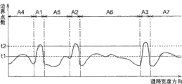
For example, in the present embodiment, as the recognizer of the image of the area I of can not travelling is as follows algorithm: image information G is carried out Boundary Detection handle, count in the border of each position that detects the Width of road 11, the place of being counted more than or equal to the threshold value of regulation in this border is identified as the area I of can not travelling.And,, as shown in Figure 9, adopt the second threshold value t2 that is set at the first threshold t1 of low value and is set at high value as the threshold value of this moment.Promptly, in regional A4 and A7 that the image of inferring the area I of can not travelling exists, adopt first threshold t1, in regional A5 and A6 in addition, adopt second threshold value, thereby adjust recognizer in regional A4 that exists at the image of inferring the area I of to travel and the A7, so that judge whether to be lower than other regional A5 and A6 for the judgment standard of the area I of can not travelling.
Fig. 9 for expression for the image information G shown in Fig. 5 (a), Fig. 5 (b), detect the result's who the border of each position of road 11 Widths counts curve map.As shown in the drawing, regional A1-A3 is owing to exist lane line P1a, P1b, P2a, so the border counts manyly, and these regional A1-A3 can not become the object of the image recognition of the area I of can not travelling.Because regional A5 has only asphalt surface except the position that inspection shaft P3 exists, so the border is counted few on the whole.
On the other hand, count and increase to a certain extent in the border of regional A4, A6, A7.On conclusion, regional A4 and A7 are respectively owing to exist walkway I1 or central partition I2 such can not travel area I and border to count to increase.With respect to this, regional A6 is owing to have the image Gs of front vehicles and be hidden in the lane line GP2b of the dotted line among the image Gs of this vehicle and count and increase in the border.But, only count according to the border, be difficult to judge whether be the area I of can not travelling.
At this moment, based on the estimation result of step #08, in the regional A4 and A7 at the image existence of inferring the area I of can not travelling, making the threshold value that is judged as the area I of can not travelling is the first threshold t1 that is set to low value.In other regional A5 and A6, making the threshold value that is judged as the area I of can not travelling is the second threshold value t2 that is set to high value.Like this,, in regional A4 and A7 that the image of inferring the area I of can not travelling exists, can reduce the omission of the area I of can not travelling, can prevent that the flase drop survey is for travelling area I in other regional A5 and A6 simultaneously based on the estimation result of step #08.Therefore, can improve the discrimination of the area I of can not travelling.The suitable numerical value of these first thresholds t1 and the second threshold value t2 can be by experiment or statistical method obtain.Also have, as 1 suitable embodiment, the value that can make these first thresholds t1 and the second threshold value t2 is a variable value, and this variable value changes based on other information of extracting from image information G or from the signal that is loaded in other sensors on the vehicle M etc.
The identification of the image by this area I of can not travelling is handled, and can carry out high-precision image recognition to area I of can not travelling such as curb, walkway, isolation strip.In the present embodiment, as shown in figure 10, the image of the coating mark P that extracts except the processing by step # 72 is also discerned the image GI2 of central partition I2 on image GP1b right side of image GI1, lane line P1b of walkway I1 in the image GP1a left side of lane line P1a respectively.
More than the series of processes of Shuo Ming step #01-#10 is carried out at interval repeatedly with official hour.Like this, the real-time image recognition of the vehicle M in can realizing travelling.
And, this pattern recognition device 1 go for to vehicle M travel control controller of vehicle and show the guider etc. of self-position.For example, when this pattern recognition device 1 is used for controller of vehicle, can discern the image recognition result of operational part 10 based on image information, the peripheral situation of identification vehicle M, for example from vehicle M to the walkway or the distance of the area I of can not travelling such as isolation strip and direction, to the distance of stop line, lane line, zebra crossing etc. and direction etc., for example therefore can suitably carry out in order to keep the track, to prevent to collide, prevent such vehicle ' controls such as the steering of accident etc. or acceleration and deceleration.
Also have, when this pattern recognition device 1 is used for guider, can discern the image recognition result of operational part 10 based on image information, compare than the situation of only utilizing GPS receiver 4, aspect sensor 5 and range sensor 6 etc. in the past, can discern self-position in further detail, therefore can carry out the detailed demonstration of self-position with for example track unit etc., perhaps can carry out route guidance etc. in the best time based on the information of the self-position of detailed identification.
(other embodiments)
(1) as mentioned above, illustrated in the embodiment shown in the process flow diagram of Fig. 4, make up first recognition processing method and second recognition processing method, the coating mark P that is provided with on the road surface to road 11, situation about discerning with the area I of can not travelling adjacent with road 11, but can certainly only utilize first recognition processing method, extract coating mark P, the candidate image of the area I of can not travelling, C compares with roadway characteristic information, will with the high candidate image of roadway characteristic information C matching as coating mark P maybe can not travel area I image and carry out image recognition.
Also have, also can only utilize second recognition processing method, maybe can not the travel image of area I of coating mark P is discerned.Promptly, position-based is determined operational part 7 determined camera sites and roadway characteristic information C, the zone of the existence of the coating mark P among the supposition image information G, the image of the area I of can not travelling, based on this estimation result, in inferring the zone that maybe can not travel coating mark P the image of area I exists, adjust recognizer, so that judge whether that the image recognition of carrying out from image information G the image of identifying object thing being discerned also is fine for maybe can not the travel judgment standard of area I of coating mark P is lower than other zone.
(2) in the above-described embodiment, be that example is illustrated with situation about pattern recognition device 1 being loaded on the vehicle M, but the purposes of this pattern recognition device 1 is not limited to be loaded on the vehicle M.That is, pattern recognition device 1 of the present invention goes for the situation that filming apparatus 2 moves on road.Also have, also go for the rest image in the road photographs is carried out image recognition.
Also having, is not that the one-piece construction of pattern recognition device 1 all must be loaded on the vehicle M.That is, a part of structure except filming apparatus 2 also can under the connected state, be arranged on outside the vehicle M by communication network such as the Internet, and the transmission of carrying out information, signal by the Internet receives, thus composing images recognition device 1.At this moment, can utilize the outer server of car etc. to carry out for example function of image information identification operational part 10.
Pattern recognition device of the present invention and image-recognizing method, go for as the situation on being loaded in vehicle etc., in the purposes of discerning processing etc. by the captured image information of filming apparatus that on road, moves.
Claims (16)
1. pattern recognition device is characterized in that having:
Image information acquisition mechanism, it obtains the image information in the road photographs,
Roadway characteristic information is obtained mechanism, and it obtains the relevant roadway characteristic information of ground thing with the camera site periphery of above-mentioned image information from cartographic information,
The image information identification mechanism, its identification that utilizes above-mentioned roadway characteristic information to carry out above-mentioned image information is handled, and the image of the identifying object thing corresponding with above-mentioned ground thing that comprised in the above-mentioned image information is discerned;
Above-mentioned image information identification mechanism is based on above-mentioned roadway characteristic information, the existing zone of image of supposition above-mentioned identifying object thing in above-mentioned image information, adjust recognizer based on this estimation result, make in the zone that the image of inferring above-mentioned identifying object thing exists to judge whether to be lower than other zone for the judgment standard of above-mentioned identifying object thing.
2. the pattern recognition device of putting down in writing according to claim 1, it is characterized in that, above-mentioned image information identification mechanism extracts the candidate image of above-mentioned identifying object thing and compares with above-mentioned roadway characteristic information from above-mentioned image information, will be identified as the image of above-mentioned identifying object thing with the high above-mentioned candidate image of above-mentioned roadway characteristic information matches.
3. according to claim 1 or 2 pattern recognition devices of being put down in writing, it is characterized in that, above-mentioned roadway characteristic information comprise with above-mentioned ground thing location information related, shape information and color information at least one side.
4. according to claim 1 or 2 pattern recognition devices of being put down in writing, it is characterized in that above-mentioned ground thing comprises the coating mark that is arranged on the pavement of road and adjacent with road a side or both sides in can not running region.
5. according to claim 1 or 2 pattern recognition devices of being put down in writing, it is characterized in that, above-mentioned roadway characteristic information is obtained mechanism, from the cartographic information that map information database had that constitutes guider, when utilizing above-mentioned filming apparatus to take above-mentioned image information, obtain the above-mentioned roadway characteristic information that the positional information that utilize to constitute above-mentioned guider is obtained the position periphery that mechanism obtains.
6. according to claim 1 or 2 pattern recognition devices of being put down in writing, it is characterized in that above-mentioned image information acquisition mechanism is loaded in filming apparatus captured image information on the vehicle with the utilization of official hour interval acquiring.
7. pattern recognition device is characterized in that having:
Image information acquisition mechanism, it obtains the image information in the road photographs;
Roadway characteristic information is obtained mechanism, and it obtains the first and second relevant roadway characteristic information of things on the ground with the camera site periphery of above-mentioned image information from cartographic information;
The first object identification mechanism, its to comprised in the above-mentioned image information, with discern than the image of the above-mentioned first first identifying object thing that on the ground thing is corresponding that is easier to discern;
Roadway characteristic information is checked mechanism, its recognition result to the image of the above-mentioned first identifying object thing of the above-mentioned first object identification mechanism compares with the above-mentioned roadway characteristic information relevant with the above-mentioned first ground thing of utilizing above-mentioned roadway characteristic information acquired, carries out checking of above-mentioned image information and above-mentioned roadway characteristic information;
The zone prediction mechanism, it checks the checked result of mechanism based on above-mentioned roadway characteristic information, infers in above-mentioned image information and the existing zone of image than the above-mentioned first identifying object thing indiscernible above-mentioned second second identifying object thing that thing is corresponding on the ground;
The second object identification mechanism, its estimation result based on the above-mentioned zone prediction mechanism is adjusted recognizer, make in the zone that the image of inferring the above-mentioned second identifying object thing exists to judge whether to be lower than other zone, discern with this image to the above-mentioned second identifying object thing that comprised in the above-mentioned image information for the judgment standard of the above-mentioned second identifying object thing.
8. the pattern recognition device of putting down in writing according to claim 7 is characterized in that,
The above-mentioned first object identification mechanism extracts the candidate image of the above-mentioned first identifying object thing from above-mentioned image information,
Above-mentioned roadway characteristic information check mechanism to the candidate image of the above-mentioned first identifying object thing with utilize above-mentioned roadway characteristic information acquired with above-mentioned first on the ground the relevant above-mentioned roadway characteristic information of thing compare, the candidate image of the above-mentioned first identifying object thing that matching is high is identified as the image of the above-mentioned first identifying object thing, and be benchmark with the image of the above-mentioned first identifying object thing discerned, carry out checking of above-mentioned image information and above-mentioned roadway characteristic information.
9. according to claim 7 or 8 pattern recognition devices of being put down in writing, it is characterized in that above-mentioned roadway characteristic information comprises and the above-mentioned first and second at least one sides in thing location information related, shape information and the color information on the ground.
10. according to claim 7 or 8 pattern recognition devices of being put down in writing, it is characterized in that, above-mentioned first on the ground thing be the coating mark that is arranged on the pavement of road, above-mentioned second on the ground thing be adjacent with road can not running region.
11. according to claim 7 or 8 pattern recognition devices of being put down in writing, it is characterized in that, above-mentioned roadway characteristic information is obtained mechanism, from the cartographic information that map information database had that constitutes guider, when utilizing above-mentioned filming apparatus to take above-mentioned image information, obtain the above-mentioned roadway characteristic information that the positional information that utilize to constitute above-mentioned guider is obtained the position periphery that mechanism obtains.
12., it is characterized in that above-mentioned image information acquisition mechanism is loaded in filming apparatus captured image information on the vehicle with the utilization of official hour interval acquiring according to claim 7 or 8 pattern recognition devices of being put down in writing.
13. a controller of vehicle is characterized in that having:
According to each described pattern recognition device in the claim 1~12;
The control gear that travels, it carries out the control of travelling of vehicle based on the recognition result of the image information identification mechanism of above-mentioned pattern recognition device.
14. a guider is characterized in that having:
Map information database, it has cartographic information;
Positional information is obtained mechanism, and it obtains self positional information;
According to each described pattern recognition device in the claim 1~12;
The self-position correction mechanism, it is revised above-mentioned self-position information based on the recognition result of the image information identification mechanism of above-mentioned pattern recognition device.
15. an image-recognizing method is characterized in that, comprising:
The image information acquisition operation is obtained the image information in the road photographs,
Roadway characteristic information is obtained operation, obtains the relevant roadway characteristic information of ground thing with the camera site periphery of above-mentioned image information from cartographic information,
Image information identification operation, the identification that utilizes above-mentioned roadway characteristic information to carry out above-mentioned image information is handled, and the image of the identifying object thing corresponding with above-mentioned ground thing that comprised in the above-mentioned image information is discerned;
In above-mentioned image information identification operation, based on above-mentioned roadway characteristic information, the existing zone of image of supposition above-mentioned identifying object thing in above-mentioned image information, adjust recognizer based on this estimation result, make in the zone that the image of inferring above-mentioned identifying object thing exists to judge whether to be lower than other zone for the judgment standard of above-mentioned identifying object thing.
16. an image-recognizing method is characterized in that, comprising:
The image information acquisition operation is obtained the image information in the road photographs;
Roadway characteristic information is obtained operation, obtains the first and second relevant roadway characteristic information of things on the ground with the camera site periphery of above-mentioned image information from cartographic information;
First object identification operation, to comprised in the above-mentioned image information, with discern than the image of the above-mentioned first first identifying object thing that thing is corresponding on the ground that is easier to discern;
Roadway characteristic information is checked operation, to the recognition result of the image of the above-mentioned first identifying object thing of above-mentioned first object identification operation with utilize above-mentioned roadway characteristic information to obtain the above-mentioned roadway characteristic information relevant that operation obtains to compare, carry out checking of above-mentioned image information and above-mentioned roadway characteristic information with the above-mentioned first identifying object thing;
Operation is inferred in the zone, checks the checked result of operation based on above-mentioned roadway characteristic information, infers in above-mentioned image information and the existing zone of image than the above-mentioned first identifying object thing indiscernible above-mentioned second second identifying object thing that thing is corresponding on the ground;
Second object identification operation, infer the estimation result adjustment recognizer of operation based on above-mentioned zone, make in the zone that the image of inferring the above-mentioned second identifying object thing exists to judge whether to be lower than other zone, discern with this image to the above-mentioned second identifying object thing that comprised in the above-mentioned image information for the judgment standard of the above-mentioned second identifying object thing.
Applications Claiming Priority (2)
| Application Number | Priority Date | Filing Date | Title |
|---|---|---|---|
| JP2005021337 | 2005-01-28 | ||
| JP2005021337A JP4321821B2 (en) | 2005-01-28 | 2005-01-28 | Image recognition apparatus and image recognition method |
Publications (2)
| Publication Number | Publication Date |
|---|---|
| CN1818929A CN1818929A (en) | 2006-08-16 |
| CN100555311C true CN100555311C (en) | 2009-10-28 |
Family
ID=36540127
Family Applications (1)
| Application Number | Title | Priority Date | Filing Date |
|---|---|---|---|
| CNB2006100069534A Expired - Fee Related CN100555311C (en) | 2005-01-28 | 2006-01-26 | Pattern recognition device and image-recognizing method |
Country Status (4)
| Country | Link |
|---|---|
| US (1) | US7668341B2 (en) |
| EP (1) | EP1686537B1 (en) |
| JP (1) | JP4321821B2 (en) |
| CN (1) | CN100555311C (en) |
Families Citing this family (49)
| Publication number | Priority date | Publication date | Assignee | Title |
|---|---|---|---|---|
| US7804424B2 (en) * | 2002-07-03 | 2010-09-28 | Iwane Laboratories, Ltd. | Automatic guide apparatus for traffic facilities |
| JP4631750B2 (en) * | 2006-03-06 | 2011-02-16 | トヨタ自動車株式会社 | Image processing system |
| JP4248558B2 (en) * | 2006-03-24 | 2009-04-02 | トヨタ自動車株式会社 | Road marking line detection device |
| JP4861850B2 (en) * | 2007-02-13 | 2012-01-25 | アイシン・エィ・ダブリュ株式会社 | Lane determination device and lane determination method |
| JP4446201B2 (en) * | 2007-03-30 | 2010-04-07 | アイシン・エィ・ダブリュ株式会社 | Image recognition apparatus and image recognition method |
| US7903883B2 (en) * | 2007-03-30 | 2011-03-08 | Microsoft Corporation | Local bi-gram model for object recognition |
| JP4569837B2 (en) * | 2007-03-30 | 2010-10-27 | アイシン・エィ・ダブリュ株式会社 | Feature information collecting apparatus and feature information collecting method |
| JP2010526359A (en) * | 2007-05-04 | 2010-07-29 | ボエグリ − グラビュル ソシエテ アノニム | Method and apparatus for identifying certification mark on object surface covered with outer cover |
| KR20090001721A (en) * | 2007-05-14 | 2009-01-09 | 팅크웨어(주) | Method for correcting map matching and navigation system implementing the method |
| JP4703605B2 (en) | 2007-05-31 | 2011-06-15 | アイシン・エィ・ダブリュ株式会社 | Feature extraction method, image recognition method and feature database creation method using the same |
| JP4497424B2 (en) * | 2007-05-31 | 2010-07-07 | アイシン・エィ・ダブリュ株式会社 | Feature recognition device, feature recognition method, lane determination device and lane determination method using the same |
| US20090037039A1 (en) * | 2007-08-01 | 2009-02-05 | General Electric Company | Method for locomotive navigation and track identification using video |
| JP4973736B2 (en) * | 2007-12-05 | 2012-07-11 | 日本電気株式会社 | Road marking recognition device, road marking recognition method, and road marking recognition program |
| JP4788778B2 (en) | 2009-01-27 | 2011-10-05 | 株式会社デンソー | Deviation warning device and deviation warning program |
| JP5066123B2 (en) * | 2009-03-24 | 2012-11-07 | 日立オートモティブシステムズ株式会社 | Vehicle driving support device |
| JP5062497B2 (en) * | 2010-03-31 | 2012-10-31 | アイシン・エィ・ダブリュ株式会社 | Vehicle position detection system using landscape image recognition |
| JP5057183B2 (en) * | 2010-03-31 | 2012-10-24 | アイシン・エィ・ダブリュ株式会社 | Reference data generation system and position positioning system for landscape matching |
| JP5062498B2 (en) * | 2010-03-31 | 2012-10-31 | アイシン・エィ・ダブリュ株式会社 | Reference data generation system and position positioning system for landscape matching |
| JP5168601B2 (en) * | 2010-03-31 | 2013-03-21 | アイシン・エィ・ダブリュ株式会社 | Own vehicle position recognition system |
| JP5099460B2 (en) * | 2010-04-28 | 2012-12-19 | アイシン・エィ・ダブリュ株式会社 | Feature information collecting apparatus and feature information collecting method |
| JP5088592B2 (en) * | 2010-04-28 | 2012-12-05 | アイシン・エィ・ダブリュ株式会社 | Own vehicle position recognition device and own vehicle position recognition program |
| JP5310942B2 (en) * | 2010-05-13 | 2013-10-09 | トヨタ自動車株式会社 | Vehicle control apparatus and vehicle control system |
| DE112010005574B4 (en) | 2010-05-19 | 2018-01-25 | Toyota Jidosha Kabushiki Kaisha | Vehicle control system |
| JP5516301B2 (en) * | 2010-10-05 | 2014-06-11 | トヨタ自動車株式会社 | Vehicle runway determination system |
| JP5626578B2 (en) * | 2010-12-02 | 2014-11-19 | アイシン・エィ・ダブリュ株式会社 | Driving support system, driving support program, and driving support method |
| JP5272042B2 (en) * | 2011-05-12 | 2013-08-28 | 富士重工業株式会社 | Environment recognition apparatus and environment recognition method |
| JP2012247840A (en) * | 2011-05-25 | 2012-12-13 | Sony Corp | Neighboring person specifying apparatus, neighboring person specifying method, neighboring person specifying program, and neighboring person specifying system |
| US9373042B2 (en) * | 2011-09-20 | 2016-06-21 | Toyota Jidosha Kabushiki Kaisha | Subject change detection system and subject change detection method |
| US9235766B2 (en) | 2011-10-20 | 2016-01-12 | International Business Machines Corporation | Optimizing the detection of objects in images |
| CN102521566B (en) * | 2011-11-25 | 2013-07-24 | 中国科学院光电技术研究所 | Low-power-consumption real-time road automatic identifying device for ground independent equipment |
| JP5929330B2 (en) * | 2012-03-05 | 2016-06-01 | 日産自動車株式会社 | Step detection device |
| JP5949955B2 (en) * | 2013-01-25 | 2016-07-13 | トヨタ自動車株式会社 | Road environment recognition system |
| JP6328254B2 (en) * | 2014-09-05 | 2018-05-23 | 三菱電機株式会社 | Automated traveling management system, server, and automated traveling management method |
| US20170120819A1 (en) * | 2014-09-29 | 2017-05-04 | Mitsubishi Electric Corporation | Information display control system and method of controlling display of information |
| KR102383425B1 (en) * | 2014-12-01 | 2022-04-07 | 현대자동차주식회사 | Electronic apparatus, control method of electronic apparatus, computer program and computer readable recording medium |
| JP6791645B2 (en) * | 2016-03-29 | 2020-11-25 | 本田技研工業株式会社 | Optical communication equipment, optical communication system, and optical communication method |
| KR102647407B1 (en) * | 2016-11-04 | 2024-03-14 | 현대모비스 주식회사 | Device and method for preventing car accident caused by obstacle |
| JP2018081404A (en) * | 2016-11-15 | 2018-05-24 | パナソニック インテレクチュアル プロパティ コーポレーション オブ アメリカPanasonic Intellectual Property Corporation of America | Discrimination method, discrimination device, discriminator generation method and discriminator generation device |
| JP6804965B2 (en) | 2016-12-15 | 2020-12-23 | 株式会社日立製作所 | Image processing equipment, image processing system, and image processing method |
| CN106504565B (en) * | 2017-01-03 | 2023-06-20 | 上海量明科技发展有限公司 | Method, device and system for judging parking position of shared vehicle |
| CN106886217B (en) * | 2017-02-24 | 2020-09-08 | 深圳中智卫安机器人技术有限公司 | Autonomous navigation control method and device |
| DE102018214959A1 (en) * | 2018-09-04 | 2020-03-05 | Robert Bosch Gmbh | Process for evaluating sensor data with extended object recognition |
| US10495476B1 (en) | 2018-09-27 | 2019-12-03 | Phiar Technologies, Inc. | Augmented reality navigation systems and methods |
| US11448518B2 (en) * | 2018-09-27 | 2022-09-20 | Phiar Technologies, Inc. | Augmented reality navigational overlay |
| CN109683613B (en) * | 2018-12-24 | 2022-04-29 | 驭势(上海)汽车科技有限公司 | Method and device for determining auxiliary control information of vehicle |
| CN111775944B (en) | 2019-04-04 | 2021-12-28 | 富泰华工业(深圳)有限公司 | Driving assistance apparatus, method, and computer-readable storage medium |
| JP7102383B2 (en) * | 2019-10-24 | 2022-07-19 | 株式会社東芝 | Road surface image management system and its road surface image management method |
| KR102206834B1 (en) * | 2020-04-28 | 2021-01-25 | 네이버랩스 주식회사 | Method and system for detecting changes in road-layout information |
| CN117237881B (en) * | 2023-11-16 | 2024-02-02 | 合肥中科类脑智能技术有限公司 | Three-span tower insulator abnormality monitoring method and device and computer equipment |
Family Cites Families (8)
| Publication number | Priority date | Publication date | Assignee | Title |
|---|---|---|---|---|
| US5351044A (en) * | 1992-08-12 | 1994-09-27 | Rockwell International Corporation | Vehicle lane position detection system |
| US6553130B1 (en) * | 1993-08-11 | 2003-04-22 | Jerome H. Lemelson | Motor vehicle warning and control system and method |
| US5638116A (en) * | 1993-09-08 | 1997-06-10 | Sumitomo Electric Industries, Ltd. | Object recognition apparatus and method |
| JP3373773B2 (en) | 1998-01-27 | 2003-02-04 | 株式会社デンソー | Lane mark recognition device, vehicle travel control device, and recording medium |
| US20020134151A1 (en) * | 2001-02-05 | 2002-09-26 | Matsushita Electric Industrial Co., Ltd. | Apparatus and method for measuring distances |
| JP3876972B2 (en) | 2001-10-12 | 2007-02-07 | 株式会社デンソー | GUIDE IMAGE GENERATION DEVICE, GUIDE IMAGE DISPLAY DEVICE, NAVIGATION DEVICE, AND PROGRAM |
| JP4327389B2 (en) * | 2001-10-17 | 2009-09-09 | 株式会社日立製作所 | Travel lane recognition device |
| JP4218441B2 (en) | 2003-06-27 | 2009-02-04 | 株式会社デンソー | On-vehicle moving body detection device |
-
2005
- 2005-01-28 JP JP2005021337A patent/JP4321821B2/en active Active
-
2006
- 2006-01-25 US US11/338,712 patent/US7668341B2/en active Active
- 2006-01-25 EP EP06001527.8A patent/EP1686537B1/en not_active Not-in-force
- 2006-01-26 CN CNB2006100069534A patent/CN100555311C/en not_active Expired - Fee Related
Also Published As
| Publication number | Publication date |
|---|---|
| JP2006209510A (en) | 2006-08-10 |
| EP1686537B1 (en) | 2015-07-29 |
| US20060228000A1 (en) | 2006-10-12 |
| EP1686537A2 (en) | 2006-08-02 |
| JP4321821B2 (en) | 2009-08-26 |
| US7668341B2 (en) | 2010-02-23 |
| EP1686537A3 (en) | 2010-12-29 |
| CN1818929A (en) | 2006-08-16 |
Similar Documents
| Publication | Publication Date | Title |
|---|---|---|
| CN100555311C (en) | Pattern recognition device and image-recognizing method | |
| CN101091103B (en) | Image recognizing apparatus and method, and position determining apparatus, vehicle controlling apparatus and navigation apparatus using the image recognizing apparatus or method | |
| JP2006208223A (en) | Vehicle position recognition device and vehicle position recognition method | |
| JP4831434B2 (en) | Feature information collection device, feature information collection program, own vehicle position recognition device, and navigation device | |
| US9120484B1 (en) | Modeling behavior based on observations of objects observed in a driving environment | |
| JP4809321B2 (en) | Traffic information calculation device, traffic information calculation program, and traffic information calculation method | |
| CN115014370A (en) | System, method, and computer-readable medium for generating map information | |
| JP6280409B2 (en) | Self-vehicle position correction method, landmark data update method, in-vehicle device, server, and self-vehicle position data correction system | |
| CN102208035A (en) | Image processing system and position measurement system | |
| JP4984152B2 (en) | Image recognition system, server device, and image recognition device | |
| CN101275839A (en) | Feature information collecting apparatus and feature information collecting method | |
| JP4775658B2 (en) | Feature recognition device, vehicle position recognition device, navigation device, feature recognition method | |
| JP4953012B2 (en) | Image recognition device, program for image recognition device, navigation device using the same, and program for navigation device | |
| JP2007178271A (en) | Own position recognition system | |
| CN116670610A (en) | System and method for common speed mapping and navigation | |
| JP4831433B2 (en) | Own vehicle position recognition device, own vehicle position recognition program, and navigation device | |
| JP4912495B2 (en) | Image recognition apparatus and method, and navigation apparatus | |
| JP2018159752A (en) | Method and device for learning map information | |
| TW201617256A (en) | Drive mode judging device and method applied to vehicle energy management | |
| JP4648697B2 (en) | Image recognition apparatus and method, and navigation apparatus | |
| CN114868381A (en) | Image processing apparatus, image processing method, and program | |
| KR20200144166A (en) | Data-based voice service system and method using machine learning algorithm | |
| JP4234071B2 (en) | Vehicle road surface sign detection device | |
| US20220212687A1 (en) | Apparatus and method for use with a vehicle | |
| JP7301897B2 (en) | map generator |
Legal Events
| Date | Code | Title | Description |
|---|---|---|---|
| C06 | Publication | ||
| PB01 | Publication | ||
| C10 | Entry into substantive examination | ||
| SE01 | Entry into force of request for substantive examination | ||
| C14 | Grant of patent or utility model | ||
| GR01 | Patent grant | ||
| CF01 | Termination of patent right due to non-payment of annual fee |
Granted publication date: 20091028 Termination date: 20210126 |
|
| CF01 | Termination of patent right due to non-payment of annual fee |