EP1189030B1 - Terminal apparatus for downloading map - Google Patents
Terminal apparatus for downloading map Download PDFInfo
- Publication number
- EP1189030B1 EP1189030B1 EP01121634A EP01121634A EP1189030B1 EP 1189030 B1 EP1189030 B1 EP 1189030B1 EP 01121634 A EP01121634 A EP 01121634A EP 01121634 A EP01121634 A EP 01121634A EP 1189030 B1 EP1189030 B1 EP 1189030B1
- Authority
- EP
- European Patent Office
- Prior art keywords
- map
- terminal apparatus
- data
- server
- downloaded
- Prior art date
- Legal status (The legal status is an assumption and is not a legal conclusion. Google has not performed a legal analysis and makes no representation as to the accuracy of the status listed.)
- Expired - Lifetime
Links
Images


Classifications
-
- G—PHYSICS
- G01—MEASURING; TESTING
- G01C—MEASURING DISTANCES, LEVELS OR BEARINGS; SURVEYING; NAVIGATION; GYROSCOPIC INSTRUMENTS; PHOTOGRAMMETRY OR VIDEOGRAMMETRY
- G01C21/00—Navigation; Navigational instruments not provided for in groups G01C1/00 - G01C19/00
- G01C21/38—Electronic maps specially adapted for navigation; Updating thereof
- G01C21/3885—Transmission of map data to client devices; Reception of map data by client devices
- G01C21/3896—Transmission of map data from central databases
-
- G—PHYSICS
- G01—MEASURING; TESTING
- G01C—MEASURING DISTANCES, LEVELS OR BEARINGS; SURVEYING; NAVIGATION; GYROSCOPIC INSTRUMENTS; PHOTOGRAMMETRY OR VIDEOGRAMMETRY
- G01C21/00—Navigation; Navigational instruments not provided for in groups G01C1/00 - G01C19/00
- G01C21/26—Navigation; Navigational instruments not provided for in groups G01C1/00 - G01C19/00 specially adapted for navigation in a road network
- G01C21/34—Route searching; Route guidance
- G01C21/36—Input/output arrangements for on-board computers
- G01C21/3679—Retrieval, searching and output of POI information, e.g. hotels, restaurants, shops, filling stations, parking facilities
Definitions
- the present invention relates to a terminal apparatus for downloading a map.
- a navigation apparatus in which a map data is stored in a storage medium such as CD-ROM, and read, upon required, by driving the storage medium with a disk driver to retrieve a guidance path.
- a place of departure and a destination are transmitted from a car-mounted server to an information center.
- the information center retrieves a guidance path from the place of departure to the destination to transmit guidance path data and map data for displaying the guidance path to the car-mounted server.
- the car-mounted server inputs the guidance path data and the map data into a navigation device.
- the navigation device conducts path guidance, employing the guidance path data and the map data.
- a document regarding a car navigation terminal apparatus and navigation method of this type is JP-A-2000-55682 specification or the like, for example.
- US 5 808 566 discloses an electronic navigation system and method.
- a remote unit has an operation for determining whether the remote unit needs additional information from a base unit.
- the remote unit requests a route between an origin and a destination from the base unit.
- the base unit calculates the route and sends it to the remote unit.
- the remote unit compares the route with map information stored on-board the remote unit. If any part is not adequately covered, the remote unit requests from the base unit strip maps for not adequately covered portions.
- the simple map is a map composed of specific sorts of roads.
- the specific sorts of roads include expressways and national roads.
- the simple map may be a rough map at lower level.
- the simple map may be a display map that does not include any map for retrieval.
- a terminal apparatus in which a simple map is installed and when a map is desired, it is checked whether or not a map of a desired place exists in the simple map, and if it exists, the map of the desired place is loaded from the simple map and data for creating a guide map including a guidance point is downloaded from a navigation server, or if it does not exist, a small sectional map including a guidance point is downloaded from the navigation server.
- the guide map involves data for guiding a travelling direction at a position permitting travelling in plural directions.
- a terminal apparatus in which a simple map is installed and when a map is desired, it is checked whether or not a map of a current position is in the simple map, and if it exists, the current position map is loaded from the simple map, or if it does not exist, the current position map is downloaded from a navigation server.
- a terminal apparatus in which a simple map comprising specific sorts of roads is installed and when a map is desired, if a car passes through the specific sorts of roads, the simple map is loaded, or if the car passes through any other road than the specific sorts of roads, a map of a current position is downloaded from a navigation server.
- the specific sorts of roads comprises expressways and national roads.
- a terminal apparatus in which a simple map is installed and when a map is desired, it is checked whether or not a map of a desired place exists in the simple map, and if it exists, the map of the desired place is loaded from the simple map, or if it does not exist, map data with flagged components is received from a navigation server.
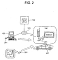
- Fig. 1 is a view showing a concept of a signal transmission and receiving system including a terminal apparatus.
- Reference numeral 101 denotes a broadcasting satellite.
- Reference numeral 102 denotes a navigation server (hereinafter simply referred to as a navi server).
- Reference numeral 103 denotes an Internet.
- Reference numeral 104 denotes a telephone.
- Reference numeral 105 denotes a PC at a store or in a house.
- Reference numeral 106 denotes a terminal apparatus.
- Reference numeral 107 denotes a car with the terminal apparatus 106 installed.
- a broadcasting signal from the broadcasting satellite 101 is received by the navi server 102, and sent through the Internet 103 and the telephone 104 to the PC 105 at the store or in the house.
- the broadcasting signal from the broadcasting satellite 101 is directly transmitted to the PC 105 at the store or in the house.
- the terminal apparatus 106 within the car 107 receives data transmitted through the telephone 104 or the Internet 103 from the navi server 102.
- the terminal apparatus 106 is connected to the Internet 103 to download via the PC at the store or in the house.
- a portable telephone may be used to download at an outside.
- a memory card 201 storing the simple maps may be bought and inserted into the terminal apparatus 106 to download.
- the simple map means any one of the following three items, or a combination thereof.
- Fig. 3 is a flowchart when the terminal apparatus loads the map.
- coordinates (latitude and longitude) of a desired place is decided (S301).
- a management table e.g., a management table of Fig. 10
- S303 it is checked whether or not there exists a map
- the map is loaded from the memory card 201 at hand or provided in the terminal apparatus 106 of Fig. 2 (S304). If not, map data is downloaded from the navi server 102 of Fig. 2 .
- the decision of the coordinates (latitude and longitude) in Fig. 3 basically is measured by a GPS receiver 406 shown in Fig. 4 .
- the map displayed on a screen of the car-navigator is scrolled in accordance with a car position.
- the latitude and longitude of the current place are transmitted to the navi server 102 to download the map.
- the latitude and longitude of the car position are transmitted to the navi server 102 to download the map, which is shown in a flowchart of Fig. 12 .
- a storage area for storing the management table is stored in the memory card 201.
- the memory card 201 also stores the map. While the software of the terminal apparatus 106 is being executed, the management table may be directly read from the memory card 201, or loaded into a DRAM 607 of Fig. 6 .
- a determination whether or not the map exists at step S303 in Fig. 3 is performed by the software of the terminal apparatus 106. Specifically, it is a plug-in 501 of Fig. 5 . As the software processing, a browser 502 receives an HTML file with map data name written, then the map data is received by the plug-in 501, and the plug-in 501 is activated to process the map data. Accordingly, a determination whether or not the map exists (rather, the overall processing of flow) is performed by the software (plug-in 501).
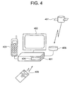
- the terminal apparatus 106 comprises a terminal apparatus main body 401, a display 402, a portable telephone 403, a memory card slot 404 provided in the terminal apparatus main body 401, a remote controller 405, and a GPS (Global Positioning System) receiver 406.
- the memory card 201 shown in Fig. 2 is inserted into the memory card slot 404.
- the GPS receiver 406 measures its own position by communicating a signal with the GPS satellite 451 (S1201). It is checked whether or not the map at the current place exists in the terminal apparatus (S1202). If it exists, the map at the current place is displayed (S1206).
- a communication confirmation screen with the navi server is displayed (S1203), and it is checked whether or not the communication is made (S1204). If the answer is yes, the map at the current place is downloaded from the navi server (S1205), and the map at the current place is displayed (S1206).
- reference numeral 501 denotes a plug-in.
- Reference numeral 502 denotes a browser.
- Reference numeral 503 denotes a 3D graphics library.
- Reference numeral 504 denotes a remote control driver.
- Reference numeral 505 denotes an RS-232C driver.
- Reference numeral 506 denotes a portable telephone driver.
- Reference numeral 507 denotes a voice decoder.
- Reference numeral 508 denotes a CF card driver.
- Reference numeral 509 denotes an OS.
- the browser 502 is activated. In this state, if the terminal apparatus 106 receives a signal from the remote controller 405, the remote control driver 504 interprets the signal. If the signal is a request for downloading data from a server on the Internet, for example, the browser 502 makes access to an appropriate server to download the data. In accordance with its data, the browser 502 activates an appropriate plug-in 501 to display the data, so that the user can inspect the data.
- the terminal apparatus 106 employs the portable telephone 403 to make access to the server.
- the portable telephone driver 506 controls the portable telephone 403.
- the voice decoder 507 can reproduce the voice data.
- the plug-in 501 employing the function of the voice decoder 507 is activated to reproduce the voice data.
- the terminal apparatus 106 has a CF (Compact Flash) card driver 508.
- the CF card driver 508 has a function of reading data stored in a CF card or storing the data in the CF card.
- the terminal apparatus 106 is provided with an RS-232C port.
- the RS-232C driver 505 controls input or output of the data through the RS-232C port.
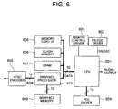
- reference numeral 601 denotes a CPU.
- Reference numeral 602 denotes an RS-232C driver.
- Reference numeral 604 denotes a PDC driver.
- Reference numeral 605 denotes a memory card I/F.
- Reference numeral 606 denotes a flash memory.
- Reference numeral 607 denotes a DRAM.
- Reference numeral 608 denotes an NTSC encoder.
- Reference numeral 609 denotes a graphics memory.
- Reference numeral 610 denotes a graphics processor.
- the CPU 601 is a processor for controlling the terminal apparatus 106 as a whole.
- the RS-232C driver 602 is employed to connect with an external device having an RS-232C interface.
- the remote control driver 603 serves to receive a signal from the remote controller.
- the PDC driver 604 controls communication employing a mobile telephone such as a portable telephone.
- the graphics processor 610 displays an image on the display unit 402.
- the graphics processor 610 draws a figure in the graphics memory 609 in accordance with instruction from the CPU 601.
- the graphics processor 610 reads periodically the image drawn with the drawing function, and the read image is converted into an NTSC signal by the NTSC encoder 608, and displayed on the display unit 402.
- the memory card I/F 605 controls input and output of the data into and from the memory card 201 inserted into the memory card slot 404.
- the flash memory 606 stores a program for activating the terminal apparatus 106.
- the flash memory 606 is a non-volatile memory, in which the contents are not lost even after the power of the terminal apparatus 106 is turned off. Accordingly, it is a suitable device for storing the program.
- the DRAM 607 is a dynamic RAM, and employed as a main memory for the CPU 601.
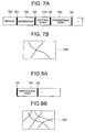
- Fig. 7 is a diagram showing a state where a map is received from the navi server.
- a map signal which is sent from the navi server 102 in Fig. 2 , has a header 701 at the first location, a delimiter D2 (a flag for the next 702), an expressway component 702, a delimiter D3 (a flag for the next 703), a national road component 703, a delimiter D4 (a flag for the next 704), and a prefectural road component 704, as shown in Fig. 7A .
- the prefectural road component 704 is attached with a sign x in Fig. 7A , whereby the terminal apparatus 106 in Fig. 7A cannot receive the prefectural road component 704, resulting in an interruption. Therefore, a map including expressway alone can be displayed on the display unit.
- Fig. 8 is a diagram showing a retransmission state when a map signal from the navi server is interrupted.
- the retransmitted data involves the prefectural road component 704 with the delimiter D4 (the flag for 704) is received, as shown in Fig. 8A .
- fine map data including the prefectural roads as well can be always received, as shown in Fig. 8B .
- Fig. 9 is a flowchart for receiving the map from the navi server. First of all, the header is received and the number of delimiters is confirmed (S901). And it is checked whether or not all the delimiters have been received (S902). If the answer is yes, the reception is ended. If the answer is no, it is checked whether or not there is reception disturbance (S903), in which if the answer is no, the procedure returns to step S902, or if the answer is yes, the data following the delimiter that could not be received is demanded (S904). Then the procedure returns to step S902, and if all the delimiters have been received, the reception is ended.
- Fig. 10 is a table showing an example of the management table of map data held by the terminal apparatus 106.
- the terminal apparatus 106 can determine whether or not the map data should be downloaded by referring to the management table when the map is needed.
- the management table is composed of the mesh ID 1001, the download date and hour 1002, and the term of service 1003.
- By making reference to the mesh ID 1001 it can be found whether or not a desired map exists in the terminal apparatus 106. If the desired map exists, the map is not downloaded, or if not, the map is downloaded. However, even if the required map is stored in the terminal apparatus 106, a considerable time may have elapsed from the time of downloading, or the term of service may be pressing or have been passed. Accordingly, even if the map exists in the terminal apparatus 106, the map must be downloaded in some cases. Therefore, the terminal apparatus 106 may determine whether or not the map is downloaded by referring to the download date and hour 1002 and the term of service 1003.
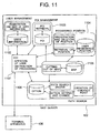
- Fig. 11 is a view showing the configuration of the navi server 102 of Fig. 2 and the terminal apparatus.
- the navi server 102 comprises a user management section 1102, a POI management section 1103, a registered place information section 1104, a map information section 1105, a guidance point creation section 1106, and a CGI 1107 for effecting approval of the user and distribution of the processing, in connection with each section.
- the CGI 1107 processes a request from the terminal apparatus 106, and activates an appropriate process.
- the user management section 1102 manages the user information.
- the user management section 1102 manages user ID and password, and determines whether or not a user who is logging in can accept the service.
- the POI management section 1103 serves to retrieve or register the POI (Point Of Interests). For example, when a request for retrieving "restaurants in city A" is issued from the terminal apparatus 106, the POI management section 1103 retrieves appropriate information. Note that this information contains at least the latitude, the longitude and the name of place. In this case, the restaurant name may be employed.
- the terminal apparatus 106 that has received the retrieved information may display the information, or set up the retrieved place as the destination or transfer place. Alternatively, the terminal apparatus 106 may make registration of the place, and at a next time and following service, the place may be set up as the destination or transfer place.
- the registered place information section 1104 manages the places that the user has registered.
- the navi server 102 can also provide a function of registering the place. For example, when the user drives to a certain place, the latitude and longitude, and name of the restaurant where the user dropped in are uploaded to the navi-sever 102, and then the navi server 102 registers the place in the registered place information section 1104. Thereafter, the user downloads the information of registered place from the registered place information section 1104, and can set up the place as the destination or transfer place.
- the registered places may be managed for each user or can be referred by other users.
- the map information section 1105 manages the map information, and cuts out a map upon a request from the terminal apparatus 106.
- the map data held by the navi server 102 is called a vector map for use with the car-navigator commercially available.
- the terminal apparatus 106 sends the latitude and longitude of that place to the navi server 102, when a map is required, the latitude and longitude being passed to the map information section 1105, which cuts out the map around an area at the latitude and longitude.
- the map data is composed of a set of small divisions called a mesh, and when a map is cut out, some sheets of mesh around the area at the latitude and longitude are taken out. The number of sheets is requested from the terminal apparatus 106. Also, the scale is also requested from the terminal apparatus 106.
- the path search section 1106 performs the path search. From the terminal apparatus 106, it receives a start place, an end place, transfer places and search conditions, performs a path search on the basis of them, and sends back a search result to the terminal apparatus 106.
- the search result includes a series of latitudes and longitudes of all the passing places arranged in the passing order, a series of all the link IDs in the passing order, and the information of the guidance points.
- the guidance point is a place needed to be guided which way to proceed at the intersection, and involves the latitude, the longitude and the guidance direction.
- the search conditions are those in performing the path search, for example, "expressway preferential", "national road preferential" and "distance preferential". Note that the search conditions are sent from the terminal apparatus 106, or may be stored in the navi server 102 in advance. In this case, the search conditions may be different from one user to another, and must be managed for each user.
- the path retrieval section 1106 performs path retrieval. It receives a start place, an end place, transfer places and retrieval conditions from the terminal apparatus 106, performs the path retrieval on the basis of them, and sends back retrieval result to the terminal apparatus 106.
- the search result includes a series of latitudes and longitudes of all the passing places arranged in the passing order, a series of all the link IDs in the passing order, and the information of the guidance points.
- the guidance point is a place necessary to be guided which way to proceed at a intersection, and involves the latitude, the longitude and the guidance direction.
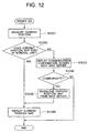
- Fig. 12 is a flowchart when the terminal apparatus displays a map of a current place.
- the terminal apparatus 106 of Fig. 2 has the GPS receiver 406, as shown in Fig. 4 .
- the GPS receiver 406 measures its current place (S1201). Then, it is checked whether or not a map at the current place exists in the terminal apparatus (S1202). If the answer is yes, the map at the current position is displayed (S1206). If the answer is no, a communication confirmation screen with the navi server is displayed (S1203). And it is checked whether or not communication is made (S1204). If the answer is no, the procedure is ended. If the answer is yes, the map at the current place is downloaded from the navi server (S1205), and the map at the current place is displayed (S1206).
- Fig. 13 is a selection screen of car navigation service menu.
- a selection screen 1301 of the car navigation service menu is a display screen of the display 402 of Fig. 4 , and displays destination setting, route confirmation, place registration, Internet and setting as the car navigation service menu.
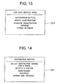
- Fig. 14 is a selection screen of the destination setting.
- the selection screen 1401 for the destination setting is a next selection screen when the destination setting is selected in the selection screen 1301 of Fig. 13 .
- the selective items of destination setting include car & drive, sports & leisure, sightseeing, shopping, eating and drinking, lodging, and transportation.
- Fig. 15 is a selection screen of the sports & leisure.
- the selection screen 1501 of the sports & leisure is a next selection screen when the sports & leisure is selected in the selection screen 1401 of Fig. 14 .
- the selective items of sports & leisure include amusement park, golf course, camp-ground, ski resort, tennis court, and skating rink.
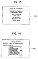
- Fig. 16 is a selection screen of the tennis court.
- the selection screen 1601 of the tennis court is a next selection screen when the tennis court is selected in the selection screen 1501 of Fig. 15 .
- the selective items of tennis court include Hokkaido, Aomori Prefecture, Iwate Prefecture, Akita Prefecture, Miyagi Prefecture, Yamagata Prefecture, Fukushima Prefecture and Ibaragi Prefecture.
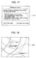
- Fig. 17 is a screen representing the retrieval result.
- a screen 1701 represents a retrieval result when Ibaragi Prefecture is selected in the selection screen 1601 of Fig. 16 .
- the items of the retrieval result include Hitachi citizens Athletic Park, Mito International Tennis Court, Hitachinaka Park, Tsuchiura Station Front Tennis School, and Toride City Athletic Park.
- Fig. 18 is a road map around the Hitachi City Athletic Park.
- a road map 1801 around the Hitachi City Athletic Park is one when Hitachi City Athletic Park is selected in the screen 1701 representing the retrieval result of Fig. 17 .
- the road map shows the Hitachi City Athletic Park 1801 of the destination, and the expressways, national roads, and prefectural roads around it.
- Fig. 19 shows an example of the information that the terminal apparatus 106 downloads as the guidance point information.
- Fig. 19A is a small sectional map 1901 containing the guidance point
- Fig. 19B is the guidance point data 1902 for creating a guide map containing the guidance point.
- the small sectional map 1901 may be created in the navi server 102, or created in the terminal apparatus 106 on the basis of the guidance point data 1902.
- the small sectional map 1901 is displayed on the display unit 402 when the car 107 comes closer to the guidance point. For example, it is displayed about 300 meters before reaching the guidance point. Naturally, the small sectional map 1901 is necessary to be created before that.
- the guidance point data 1902 is those for creating a map containing the guidance point, including, for example, the latitude and longitude of the guidance point, the admission side absolute link ID, and the escape side absolute link ID.
- the guidance point data 1902 is downloaded into the terminal apparatus 106, together with the result of path search in the navi server 102, and therefore, when the car 107 starts to move, the guidance point data 1902 is already held in the terminal apparatus 106. Accordingly, while always grasping whether or not the car 107 is approaching to the guidance point, the small sectional map 1901 can be created and displayed, if the car approaches the place where the small sectional map 1901 should be displayed.
- the small sectional map 1901 may be created in the navi server 102, and downloaded into the terminal apparatus 106.
- the terminal apparatus 106 transmits the latitude and longitude of the car 107 to the navi server 102 and the navi server 102 creates the small sectional map 1901. If the navi server 102 does not have the path information, the terminal apparatus 106 transmits the guidance point information to the navi server 102 and the navi server 102 creates the small sectional map 1901.
- Fig. 20 is a flowchart for determining whether or not a map is downloaded from the navi server.
- the path data is received (S2001), and the sort of road on the path is investigated (S2002). It is checked whether or not the car passes through any other road than the expressway and the national road (S2003). If the answer is yes, it is checked whether or not a mesh containing the road is already downloaded (S2004), and if the answer is no, the mesh containing the road is downloaded (S2005). Then it is checked whether or not all the roads are investigated (S2006). If the answer is no, the procedure returns to step S2002. If the answer is no at step S2003, and if the answer is yes at step S2004, the procedure transfers to step S2006. And if the answer is yes at step S2006, the procedure is ended.
- Fig. 21 is a flowchart of an embodiment of the present invention for downloading a map edited in accordance with a remaining storable capacity of a medium for the simple map at the time of downloading a map from the navigation server.
- the remaining storable capacity of the medium 201 for the simple map is investigated (S2101). Then, the remaining storable capacity, together with a map of a desired place, is transmitted to the navi server 102.
- the navi server 102 receives the transmitted signal, and cuts out the map of the desired place (S2103). And if the remaining storable capacity is equal to or less than the total map capacity, the roads other than the expressway and the national road are deleted (S2104). Then, map capacity is transmitted to the terminal apparatus 106 (S2105).
- the terminal apparatus 106 receives the transmitted signal, and checks whether or not the map can be contained in the medium (S2106). If the answer is no, the oldest accessed map is deleted (S2107). The procedure returns to step S2106. If the answer is yes at step S2106, the procedure transfers to step S2108 to download the map.
Description
- The present invention relates to a terminal apparatus for downloading a map.
- As a car-mounted equipment, there is a navigation apparatus in which a map data is stored in a storage medium such as CD-ROM, and read, upon required, by driving the storage medium with a disk driver to retrieve a guidance path.
- Alternatively, there is a known navigation method. In the known navigation method, a place of departure and a destination are transmitted from a car-mounted server to an information center. The information center retrieves a guidance path from the place of departure to the destination to transmit guidance path data and map data for displaying the guidance path to the car-mounted server. The car-mounted server inputs the guidance path data and the map data into a navigation device. The navigation device conducts path guidance, employing the guidance path data and the map data.
- A document regarding a car navigation terminal apparatus and navigation method of this type is
JP-A-2000-55682 - However, in the above-described car navigation apparatus, there is a problem that it is expensive because the storage medium such as CD-ROM for storing the map data and the driver are equipped with the car navigation apparatus itself. In the above-described navigation method, the storage medium and the driver are not needed and therefore, a low cost can be achieved. There is, however, a problem that telecommunication time becomes longer and telecommunication fee becomes higher, because it is required to download the guidance path data and the map data from the information center every time of telecommunication.
-
US 5 808 566 discloses an electronic navigation system and method. A remote unit has an operation for determining whether the remote unit needs additional information from a base unit. The remote unit requests a route between an origin and a destination from the base unit. The base unit calculates the route and sends it to the remote unit. The remote unit compares the route with map information stored on-board the remote unit. If any part is not adequately covered, the remote unit requests from the base unit strip maps for not adequately covered portions. - It is an object of the present invention to provide a terminal apparatus in which telecommunication load is reduced and the telecommunication fee is less expensive.
- There is provided a terminal navigation apparatus according to claim 1.
- The simple map is a map composed of specific sorts of roads.
- The specific sorts of roads include expressways and national roads.
- The simple map may be a rough map at lower level.
- The simple map may be a display map that does not include any map for retrieval.
- According to another aspect, there is provided a terminal apparatus in which a simple map is installed and when a map is desired, it is checked whether or not a map of a desired place exists in the simple map, and if it exists, the map of the desired place is loaded from the simple map and data for creating a guide map including a guidance point is downloaded from a navigation server, or if it does not exist, a small sectional map including a guidance point is downloaded from the navigation server.
- The guide map involves data for guiding a travelling direction at a position permitting travelling in plural directions.
- According to another aspect, there is provided a terminal apparatus in which a simple map is installed and when a map is desired, it is checked whether or not a map of a current position is in the simple map, and if it exists, the current position map is loaded from the simple map, or if it does not exist, the current position map is downloaded from a navigation server.
- According to another aspect , there is provided a terminal apparatus in which a simple map comprising specific sorts of roads is installed and when a map is desired, if a car passes through the specific sorts of roads, the simple map is loaded, or if the car passes through any other road than the specific sorts of roads, a map of a current position is downloaded from a navigation server.
- The specific sorts of roads comprises expressways and national roads.
- According to another aspect, there is provided a terminal apparatus in which a simple map is installed and when a map is desired, it is checked whether or not a map of a desired place exists in the simple map, and if it exists, the map of the desired place is loaded from the simple map, or if it does not exist, map data with flagged components is received from a navigation server.
- In receiving the map data with flagged components, if there is a radio disturbance, the map data following the map data directly before a flag that could not be received is demanded to receive all the flagged components.
-
-
Fig. 1 is a view showing a concept of a terminal apparatus; -
Fig. 2 is a view showing an example of the terminal apparatus; -
Fig. 3 is a flowchart when the terminal apparatus loads a map; -
Fig. 4 is an external view of an example of the terminal apparatus; -
Fig. 5 is a view showing a software configuration for the terminal apparatus; -
Fig. 6 is a view showing a hardware configuration for the terminal apparatus; -
Fig. 7A is a diagram showing a map signal from a navigation server; -
Fig. 7B is a view showing a map displayed on a display; -
Fig. 8A is a diagram showing a retransmission map signal when there is an interruption in receiving the map from the navigation server; -
Fig. 8B is a view showing a map displayed on the display; -
Fig. 9 is a flowchart for receiving a map from the navigation server; -
Fig. 10 is a diagram showing an example of a management table of map data held by the terminal apparatus; -
Fig. 11 is a view showing the configuration of the navigation server ofFig. 2 and the terminal apparatus; -
Fig. 12 is a flowchart when the terminal apparatus displays a map of a current position; -
Fig. 13 shows a selection screen for a car navigation service menu; -
Fig. 14 shows a selection screen for a destination set-up; -
Fig. 15 shows a selection screen for sports and leisure; -
Fig. 16 shows a selection screen for a tennis court; -
Fig. 17 is a screen showing a retrieved result; -
Fig. 18 is a road map around Hitachi Citizens Athletic Park; -
Fig. 19 is a view showing an example of information that the terminal apparatus downloads as guidance point information;Fig. 19A is a sectional map including a guidance point;Fig. 19B is the guidance point data for producing a guide map including the guidance point; -
Fig. 20 is a flowchart for determining whether or not a map is downloaded from the navigation server; and -
Fig. 21 is a flowchart of an embodiment of the invention for downloading a map edited in accordance with a remaining storable capacity of a medium for the simple map at the time of downloading a map from the navigation server. -
Fig. 1 is a view showing a concept of a signal transmission and receiving system including a terminal apparatus.Reference numeral 101 denotes a broadcasting satellite.Reference numeral 102 denotes a navigation server (hereinafter simply referred to as a navi server).Reference numeral 103 denotes an Internet.Reference numeral 104 denotes a telephone.Reference numeral 105 denotes a PC at a store or in a house.Reference numeral 106 denotes a terminal apparatus.Reference numeral 107 denotes a car with theterminal apparatus 106 installed. - A broadcasting signal from the
broadcasting satellite 101 is received by thenavi server 102, and sent through theInternet 103 and thetelephone 104 to thePC 105 at the store or in the house. Alternatively, the broadcasting signal from thebroadcasting satellite 101 is directly transmitted to thePC 105 at the store or in the house. Theterminal apparatus 106 within thecar 107 receives data transmitted through thetelephone 104 or theInternet 103 from thenavi server 102. - Referring now to
Fig. 2 , there are three modes to download. Theterminal apparatus 106 is connected to theInternet 103 to download via the PC at the store or in the house. A portable telephone may be used to download at an outside. Amemory card 201 storing the simple maps may be bought and inserted into theterminal apparatus 106 to download. - Herein, the simple map means any one of the following three items, or a combination thereof.
- (1) Maps made up of principal roads consisting of the specific sorts of roads, for example, expressways and national roads.
- (2) Rough maps at lower level.
- (3) Display maps that dons not include any map for retrieval.
-
Fig. 3 is a flowchart when the terminal apparatus loads the map. First of all, coordinates (latitude and longitude) of a desired place is decided (S301). Then, reference is made to a management table (e.g., a management table ofFig. 10 ) (S302), and it is checked whether or not there exists a map (S303). If there is a map, the map is loaded from thememory card 201 at hand or provided in theterminal apparatus 106 ofFig. 2 (S304). If not, map data is downloaded from thenavi server 102 ofFig. 2 . - Herein, the decision of the coordinates (latitude and longitude) in
Fig. 3 basically is measured by aGPS receiver 406 shown inFig. 4 . During car running, the map displayed on a screen of the car-navigator is scrolled in accordance with a car position. At this time, if the map to be displayed exists in theterminal apparatus 106 ofFigs. 1 and2 , that map is loaded, or if the map does not exist, the latitude and longitude of the current place are transmitted to thenavi server 102 to download the map. Also, when it is found that the map at the car position does not exist in theterminal apparatus 106, the latitude and longitude of the car position are transmitted to thenavi server 102 to download the map, which is shown in a flowchart ofFig. 12 . - A storage area for storing the management table is stored in the
memory card 201. Thememory card 201 also stores the map. While the software of theterminal apparatus 106 is being executed, the management table may be directly read from thememory card 201, or loaded into aDRAM 607 ofFig. 6 . - A determination whether or not the map exists at step S303 in
Fig. 3 is performed by the software of theterminal apparatus 106. Specifically, it is a plug-in 501 ofFig. 5 . As the software processing, abrowser 502 receives an HTML file with map data name written, then the map data is received by the plug-in 501, and the plug-in 501 is activated to process the map data. Accordingly, a determination whether or not the map exists (rather, the overall processing of flow) is performed by the software (plug-in 501). - Referring now to
Fig. 4 , theterminal apparatus 106 comprises a terminal apparatusmain body 401, adisplay 402, aportable telephone 403, amemory card slot 404 provided in the terminal apparatusmain body 401, aremote controller 405, and a GPS (Global Positioning System)receiver 406. Herein, thememory card 201 shown inFig. 2 is inserted into thememory card slot 404. Referring also toFig. 12 , theGPS receiver 406 measures its own position by communicating a signal with the GPS satellite 451 (S1201). It is checked whether or not the map at the current place exists in the terminal apparatus (S1202). If it exists, the map at the current place is displayed (S1206). If it does not exist, a communication confirmation screen with the navi server is displayed (S1203), and it is checked whether or not the communication is made (S1204). If the answer is yes, the map at the current place is downloaded from the navi server (S1205), and the map at the current place is displayed (S1206). - Referring now to
Fig. 5 ,reference numeral 501 denotes a plug-in.Reference numeral 502 denotes a browser.Reference numeral 503 denotes a 3D graphics library.Reference numeral 504 denotes a remote control driver.Reference numeral 505 denotes an RS-232C driver.Reference numeral 506 denotes a portable telephone driver.Reference numeral 507 denotes a voice decoder.Reference numeral 508 denotes a CF card driver.Reference numeral 509 denotes an OS. - If a power of the
terminal apparatus 106 is turned on, firstly, thebrowser 502 is activated. In this state, if theterminal apparatus 106 receives a signal from theremote controller 405, theremote control driver 504 interprets the signal. If the signal is a request for downloading data from a server on the Internet, for example, thebrowser 502 makes access to an appropriate server to download the data. In accordance with its data, thebrowser 502 activates an appropriate plug-in 501 to display the data, so that the user can inspect the data. - The
terminal apparatus 106 employs theportable telephone 403 to make access to the server. Theportable telephone driver 506 controls theportable telephone 403. In the case where the data downloaded from the server contains voice data, thevoice decoder 507 can reproduce the voice data. In this case, the plug-in 501 employing the function of thevoice decoder 507 is activated to reproduce the voice data. - Further, the
terminal apparatus 106 has a CF (Compact Flash)card driver 508. TheCF card driver 508 has a function of reading data stored in a CF card or storing the data in the CF card. To extend the function by connecting some device to theterminal apparatus 106, theterminal apparatus 106 is provided with an RS-232C port. The RS-232C driver 505 controls input or output of the data through the RS-232C port. - Referring now to
Fig. 6 ,reference numeral 601 denotes a CPU.Reference numeral 602 denotes an RS-232C driver.Reference numeral 604 denotes a PDC driver.Reference numeral 605 denotes a memory card I/F. Reference numeral 606 denotes a flash memory.Reference numeral 607 denotes a DRAM.Reference numeral 608 denotes an NTSC encoder.Reference numeral 609 denotes a graphics memory.Reference numeral 610 denotes a graphics processor. - The
CPU 601 is a processor for controlling theterminal apparatus 106 as a whole. The RS-232C driver 602 is employed to connect with an external device having an RS-232C interface. Theremote control driver 603 serves to receive a signal from the remote controller. ThePDC driver 604 controls communication employing a mobile telephone such as a portable telephone. - The
graphics processor 610 displays an image on thedisplay unit 402. Thegraphics processor 610 draws a figure in thegraphics memory 609 in accordance with instruction from theCPU 601. Thegraphics processor 610 reads periodically the image drawn with the drawing function, and the read image is converted into an NTSC signal by theNTSC encoder 608, and displayed on thedisplay unit 402. - The memory card I/
F 605 controls input and output of the data into and from thememory card 201 inserted into thememory card slot 404. Theflash memory 606 stores a program for activating theterminal apparatus 106. Theflash memory 606 is a non-volatile memory, in which the contents are not lost even after the power of theterminal apparatus 106 is turned off. Accordingly, it is a suitable device for storing the program. TheDRAM 607 is a dynamic RAM, and employed as a main memory for theCPU 601. -
Fig. 7 is a diagram showing a state where a map is received from the navi server. A map signal, which is sent from thenavi server 102 inFig. 2 , has aheader 701 at the first location, a delimiter D2 (a flag for the next 702), anexpressway component 702, a delimiter D3 (a flag for the next 703), anational road component 703, a delimiter D4 (a flag for the next 704), and aprefectural road component 704, as shown inFig. 7A . However, theprefectural road component 704 is attached with a sign x inFig. 7A , whereby theterminal apparatus 106 inFig. 7A cannot receive theprefectural road component 704, resulting in an interruption. Therefore, a map including expressway alone can be displayed on the display unit. -
Fig. 8 is a diagram showing a retransmission state when a map signal from the navi server is interrupted. When receiving the map signal from the navi server is interrupted, the retransmitted data involves theprefectural road component 704 with the delimiter D4 (the flag for 704) is received, as shown inFig. 8A . Accordingly, fine map data including the prefectural roads as well can be always received, as shown inFig. 8B . -
Fig. 9 is a flowchart for receiving the map from the navi server. First of all, the header is received and the number of delimiters is confirmed (S901). And it is checked whether or not all the delimiters have been received (S902). If the answer is yes, the reception is ended. If the answer is no, it is checked whether or not there is reception disturbance (S903), in which if the answer is no, the procedure returns to step S902, or if the answer is yes, the data following the delimiter that could not be received is demanded (S904). Then the procedure returns to step S902, and if all the delimiters have been received, the reception is ended. -
Fig. 10 is a table showing an example of the management table of map data held by theterminal apparatus 106. Theterminal apparatus 106 can determine whether or not the map data should be downloaded by referring to the management table when the map is needed. The management table is composed of themesh ID 1001, the download date andhour 1002, and the term ofservice 1003. By making reference to themesh ID 1001, it can be found whether or not a desired map exists in theterminal apparatus 106. If the desired map exists, the map is not downloaded, or if not, the map is downloaded. However, even if the required map is stored in theterminal apparatus 106, a considerable time may have elapsed from the time of downloading, or the term of service may be pressing or have been passed. Accordingly, even if the map exists in theterminal apparatus 106, the map must be downloaded in some cases. Therefore, theterminal apparatus 106 may determine whether or not the map is downloaded by referring to the download date andhour 1002 and the term ofservice 1003. -
Fig. 11 is a view showing the configuration of thenavi server 102 ofFig. 2 and the terminal apparatus. Thenavi server 102 comprises auser management section 1102, aPOI management section 1103, a registeredplace information section 1104, amap information section 1105, a guidancepoint creation section 1106, and aCGI 1107 for effecting approval of the user and distribution of the processing, in connection with each section. - The
CGI 1107 processes a request from theterminal apparatus 106, and activates an appropriate process. Theuser management section 1102 manages the user information. Theuser management section 1102 manages user ID and password, and determines whether or not a user who is logging in can accept the service. - The
POI management section 1103 serves to retrieve or register the POI (Point Of Interests). For example, when a request for retrieving "restaurants in city A" is issued from theterminal apparatus 106, thePOI management section 1103 retrieves appropriate information. Note that this information contains at least the latitude, the longitude and the name of place. In this case, the restaurant name may be employed. Theterminal apparatus 106 that has received the retrieved information may display the information, or set up the retrieved place as the destination or transfer place. Alternatively, theterminal apparatus 106 may make registration of the place, and at a next time and following service, the place may be set up as the destination or transfer place. - The registered
place information section 1104 manages the places that the user has registered. In the above, an example of registering the place in theterminal apparatus 106 has been stated, but thenavi server 102 can also provide a function of registering the place. For example, when the user drives to a certain place, the latitude and longitude, and name of the restaurant where the user dropped in are uploaded to the navi-sever 102, and then thenavi server 102 registers the place in the registeredplace information section 1104. Thereafter, the user downloads the information of registered place from the registeredplace information section 1104, and can set up the place as the destination or transfer place. The registered places may be managed for each user or can be referred by other users. - The
map information section 1105 manages the map information, and cuts out a map upon a request from theterminal apparatus 106. The map data held by thenavi server 102 is called a vector map for use with the car-navigator commercially available. Theterminal apparatus 106 sends the latitude and longitude of that place to thenavi server 102, when a map is required, the latitude and longitude being passed to themap information section 1105, which cuts out the map around an area at the latitude and longitude. The map data is composed of a set of small divisions called a mesh, and when a map is cut out, some sheets of mesh around the area at the latitude and longitude are taken out. The number of sheets is requested from theterminal apparatus 106. Also, the scale is also requested from theterminal apparatus 106. - The
path search section 1106 performs the path search. From theterminal apparatus 106, it receives a start place, an end place, transfer places and search conditions, performs a path search on the basis of them, and sends back a search result to theterminal apparatus 106. The search result includes a series of latitudes and longitudes of all the passing places arranged in the passing order, a series of all the link IDs in the passing order, and the information of the guidance points. Herein, the guidance point is a place needed to be guided which way to proceed at the intersection, and involves the latitude, the longitude and the guidance direction. Also, the search conditions are those in performing the path search, for example, "expressway preferential", "national road preferential" and "distance preferential". Note that the search conditions are sent from theterminal apparatus 106, or may be stored in thenavi server 102 in advance. In this case, the search conditions may be different from one user to another, and must be managed for each user. - The
path retrieval section 1106 performs path retrieval. It receives a start place, an end place, transfer places and retrieval conditions from theterminal apparatus 106, performs the path retrieval on the basis of them, and sends back retrieval result to theterminal apparatus 106. The search result includes a series of latitudes and longitudes of all the passing places arranged in the passing order, a series of all the link IDs in the passing order, and the information of the guidance points. Herein, the guidance point is a place necessary to be guided which way to proceed at a intersection, and involves the latitude, the longitude and the guidance direction. -
Fig. 12 is a flowchart when the terminal apparatus displays a map of a current place. Herein, theterminal apparatus 106 ofFig. 2 has theGPS receiver 406, as shown inFig. 4 . InFig. 12 , first of all, theGPS receiver 406 measures its current place (S1201). Then, it is checked whether or not a map at the current place exists in the terminal apparatus (S1202). If the answer is yes, the map at the current position is displayed (S1206). If the answer is no, a communication confirmation screen with the navi server is displayed (S1203). And it is checked whether or not communication is made (S1204). If the answer is no, the procedure is ended. If the answer is yes, the map at the current place is downloaded from the navi server (S1205), and the map at the current place is displayed (S1206). -
Fig. 13 is a selection screen of car navigation service menu. Aselection screen 1301 of the car navigation service menu is a display screen of thedisplay 402 ofFig. 4 , and displays destination setting, route confirmation, place registration, Internet and setting as the car navigation service menu. -
Fig. 14 is a selection screen of the destination setting. Theselection screen 1401 for the destination setting is a next selection screen when the destination setting is selected in theselection screen 1301 ofFig. 13 . The selective items of destination setting include car & drive, sports & leisure, sightseeing, shopping, eating and drinking, lodging, and transportation. -
Fig. 15 is a selection screen of the sports & leisure. Theselection screen 1501 of the sports & leisure is a next selection screen when the sports & leisure is selected in theselection screen 1401 ofFig. 14 . The selective items of sports & leisure include amusement park, golf course, camp-ground, ski resort, tennis court, and skating rink. -
Fig. 16 is a selection screen of the tennis court. Theselection screen 1601 of the tennis court is a next selection screen when the tennis court is selected in theselection screen 1501 ofFig. 15 . The selective items of tennis court include Hokkaido, Aomori Prefecture, Iwate Prefecture, Akita Prefecture, Miyagi Prefecture, Yamagata Prefecture, Fukushima Prefecture and Ibaragi Prefecture. -
Fig. 17 is a screen representing the retrieval result. Ascreen 1701 represents a retrieval result when Ibaragi Prefecture is selected in theselection screen 1601 ofFig. 16 . The items of the retrieval result include Hitachi Citizens Athletic Park, Mito International Tennis Court, Hitachinaka Park, Tsuchiura Station Front Tennis School, and Toride City Athletic Park. -
Fig. 18 is a road map around the Hitachi City Athletic Park. Aroad map 1801 around the Hitachi City Athletic Park is one when Hitachi City Athletic Park is selected in thescreen 1701 representing the retrieval result ofFig. 17 . The road map shows the Hitachi CityAthletic Park 1801 of the destination, and the expressways, national roads, and prefectural roads around it. -
Fig. 19 shows an example of the information that theterminal apparatus 106 downloads as the guidance point information.Fig. 19A is a smallsectional map 1901 containing the guidance point, andFig. 19B is theguidance point data 1902 for creating a guide map containing the guidance point. The smallsectional map 1901 may be created in thenavi server 102, or created in theterminal apparatus 106 on the basis of theguidance point data 1902. - The small
sectional map 1901 is displayed on thedisplay unit 402 when thecar 107 comes closer to the guidance point. For example, it is displayed about 300 meters before reaching the guidance point. Naturally, the smallsectional map 1901 is necessary to be created before that. - The
guidance point data 1902 is those for creating a map containing the guidance point, including, for example, the latitude and longitude of the guidance point, the admission side absolute link ID, and the escape side absolute link ID. Theguidance point data 1902 is downloaded into theterminal apparatus 106, together with the result of path search in thenavi server 102, and therefore, when thecar 107 starts to move, theguidance point data 1902 is already held in theterminal apparatus 106. Accordingly, while always grasping whether or not thecar 107 is approaching to the guidance point, the smallsectional map 1901 can be created and displayed, if the car approaches the place where the smallsectional map 1901 should be displayed. - Also, the small
sectional map 1901 may be created in thenavi server 102, and downloaded into theterminal apparatus 106. In this case, if the guidance point information is held by thenavi server 102, it may be possible that theterminal apparatus 106 transmits the latitude and longitude of thecar 107 to thenavi server 102 and thenavi server 102 creates the smallsectional map 1901. If thenavi server 102 does not have the path information, theterminal apparatus 106 transmits the guidance point information to thenavi server 102 and thenavi server 102 creates the smallsectional map 1901. -
Fig. 20 is a flowchart for determining whether or not a map is downloaded from the navi server. First of all, the path data is received (S2001), and the sort of road on the path is investigated (S2002). It is checked whether or not the car passes through any other road than the expressway and the national road (S2003). If the answer is yes, it is checked whether or not a mesh containing the road is already downloaded (S2004), and if the answer is no, the mesh containing the road is downloaded (S2005). Then it is checked whether or not all the roads are investigated (S2006). If the answer is no, the procedure returns to step S2002. If the answer is no at step S2003, and if the answer is yes at step S2004, the procedure transfers to step S2006. And if the answer is yes at step S2006, the procedure is ended. -
Fig. 21 is a flowchart of an embodiment of the present invention for downloading a map edited in accordance with a remaining storable capacity of a medium for the simple map at the time of downloading a map from the navigation server. - First of all, the remaining storable capacity of the medium 201 for the simple map is investigated (S2101). Then, the remaining storable capacity, together with a map of a desired place, is transmitted to the
navi server 102. Thenavi server 102 receives the transmitted signal, and cuts out the map of the desired place (S2103). And if the remaining storable capacity is equal to or less than the total map capacity, the roads other than the expressway and the national road are deleted (S2104). Then, map capacity is transmitted to the terminal apparatus 106 (S2105). - The
terminal apparatus 106 receives the transmitted signal, and checks whether or not the map can be contained in the medium (S2106). If the answer is no, the oldest accessed map is deleted (S2107). The procedure returns to step S2106. If the answer is yes at step S2106, the procedure transfers to step S2108 to download the map.
Claims (8)
- A terminal navigation apparatus (106) in which a map is installed and which is arranged so that when a map is desired, it is checked whether or not a map of a desired place exists in the installed map, and if it exists, the map of the desired place is loaded from the installed map,
characterized in that it is further arranged so that,
if it does not exist, a remaining storing capacity of the medium storing the installed map is notified to a navigation server (102), and a map edited in accordance with the remaining storing capacity is downloaded from the navigation server. - A terminal apparatus according to claim 1, wherein said installed map is a map composed of specific sorts of roads.
- A terminal apparatus according to claim 2, wherein said specific sorts of roads include expressways and national roads.
- A terminal apparatus according to claim 1 wherein if the map of the desired place exists in the installed map, data for creating a guide map including a guidance point is downloaded from a navigation server (102), or if it does not exist, a sectional map including a guidance point is downloaded from the navigation server.
- A terminal apparatus according to claim 4, wherein said guide map involves data for guiding a travelling direction at a position permitting travelling in plural directions.
- A terminal apparatus according to claim 1 wherein when a map is desired, it is checked whether or not a map of a current position is in the installed map, and if it exists, the current position map is loaded from the installed map, or if it does not exist, the current position map is downloaded from a navigation server.
- The terminal apparatus (106) of claim 1 in which, if the map of the desired place does not exist, map data with flagged components (1811) is received from a navigation server (102).
- A terminal apparatus according to claim 7, wherein upon receiving said map data with flagged components, if there is a radio disturbance, the map data following the map data directly before a flag that could not be received is demanded to receive all the flagged components.
Applications Claiming Priority (2)
| Application Number | Priority Date | Filing Date | Title |
|---|---|---|---|
| JP2000283794A JP4490566B2 (en) | 2000-09-13 | 2000-09-13 | Terminal device and navigation server |
| JP2000283794 | 2000-09-13 |
Publications (3)
| Publication Number | Publication Date |
|---|---|
| EP1189030A2 EP1189030A2 (en) | 2002-03-20 |
| EP1189030A3 EP1189030A3 (en) | 2004-09-22 |
| EP1189030B1 true EP1189030B1 (en) | 2008-09-17 |
Family
ID=18768102
Family Applications (1)
| Application Number | Title | Priority Date | Filing Date |
|---|---|---|---|
| EP01121634A Expired - Lifetime EP1189030B1 (en) | 2000-09-13 | 2001-09-12 | Terminal apparatus for downloading map |
Country Status (4)
| Country | Link |
|---|---|
| US (3) | US20020032521A1 (en) |
| EP (1) | EP1189030B1 (en) |
| JP (1) | JP4490566B2 (en) |
| DE (1) | DE60135815D1 (en) |
Cited By (1)
| Publication number | Priority date | Publication date | Assignee | Title |
|---|---|---|---|---|
| RU2578643C1 (en) * | 2015-01-30 | 2016-03-27 | Открытое Акционерное Общество "Российские Железные Дороги" | System for real-time transmission of warning and electronic maps to high-speed train |
Families Citing this family (20)
| Publication number | Priority date | Publication date | Assignee | Title |
|---|---|---|---|---|
| US20040204848A1 (en) * | 2002-06-20 | 2004-10-14 | Shigeru Matsuo | Navigation apparatus for receiving delivered information |
| US8977284B2 (en) | 2001-10-04 | 2015-03-10 | Traxcell Technologies, LLC | Machine for providing a dynamic data base of geographic location information for a plurality of wireless devices and process for making same |
| DE10244329A1 (en) * | 2002-09-23 | 2004-04-01 | Daimlerchrysler Ag | Sensor device for a motor vehicle system |
| JP3870911B2 (en) * | 2003-02-10 | 2007-01-24 | 日産自動車株式会社 | Lane departure prevention device |
| TWM247930U (en) * | 2003-09-23 | 2004-10-21 | Prolific Technology Inc | 3D electronic map device |
| EP1531322A3 (en) | 2003-11-13 | 2007-09-05 | Matsushita Electric Industrial Co., Ltd. | Map display apparatus |
| JP2005156405A (en) * | 2003-11-27 | 2005-06-16 | Pioneer Electronic Corp | Navigation system |
| KR20060129063A (en) * | 2004-03-25 | 2006-12-14 | 가부시키가이샤 자나비 인포메틱스 | Traffic information collecting system for navigation device |
| ITBZ20040022A1 (en) * | 2004-05-24 | 2004-08-24 | Sitour Italia S R L | ELECTRONIC INTERACTIVE PANORAMIC DEVICE |
| JP2006010441A (en) * | 2004-06-24 | 2006-01-12 | Kyocera Corp | Mobile communication terminal and map display system |
| US20060178813A1 (en) * | 2005-02-07 | 2006-08-10 | E-Lead Electronics Co., Ltd. | Auxiliary method for setting vehicle satellite navigating destinations |
| US8121610B2 (en) | 2006-03-31 | 2012-02-21 | Research In Motion Limited | Methods and apparatus for associating mapping functionality and information in contact lists of mobile communication devices |
| US20080114543A1 (en) * | 2006-11-14 | 2008-05-15 | Interchain Solution Private Limited | Mobile phone based navigation system |
| US8070628B2 (en) * | 2007-09-18 | 2011-12-06 | Callaway Golf Company | Golf GPS device |
| US20090305819A1 (en) * | 2008-06-04 | 2009-12-10 | Scott Denton | Golf gps device |
| US8290511B2 (en) * | 2009-10-01 | 2012-10-16 | Qualcomm Incorporated | Venue application for mobile station position estimation |
| EP2543963B1 (en) * | 2011-07-08 | 2020-05-13 | Harman Becker Automotive Systems GmbH | Method of updating a database of a navigation device and navigation device associated thereto |
| US9992628B2 (en) * | 2016-04-21 | 2018-06-05 | Microsoft Technology Licensing, Llc | Map downloading based on user's future location |
| JP2021006798A (en) * | 2019-06-28 | 2021-01-21 | 株式会社Jvcケンウッド | Navigation device, route guidance method, and computer program |
| KR20220006993A (en) * | 2020-07-09 | 2022-01-18 | 엠지 이노베이션 랩, 아이엔씨. 디비에이 글로벌루어 | Method and apparatus for recommending travel itinerary scheduling |
Family Cites Families (26)
| Publication number | Priority date | Publication date | Assignee | Title |
|---|---|---|---|---|
| JP3017772B2 (en) * | 1990-06-06 | 2000-03-13 | マツダ株式会社 | Vehicle navigation device |
| US5543789A (en) * | 1994-06-24 | 1996-08-06 | Shields Enterprises, Inc. | Computerized navigation system |
| KR970002795A (en) | 1995-10-30 | 1997-01-28 | 모리 하루오 | Navigation device |
| JP3743037B2 (en) | 1995-11-01 | 2006-02-08 | 株式会社日立製作所 | Information providing method to mobile terminal, information providing system, and mobile terminal |
| JPH1089976A (en) * | 1996-09-13 | 1998-04-10 | Hitachi Ltd | Information display and navigation system |
| US6049892C1 (en) * | 1997-02-24 | 2002-06-04 | Ethos Software Corp | Process and apparatus for downloading data from a server computer to a client computer |
| US6404739B1 (en) * | 1997-04-30 | 2002-06-11 | Sony Corporation | Transmitter and transmitting method, receiver and receiving method, and transceiver and transmitting/receiving method |
| JP3372021B2 (en) * | 1997-05-01 | 2003-01-27 | 松下電器産業株式会社 | Map information providing system |
| JPH10307038A (en) * | 1997-05-07 | 1998-11-17 | Alpine Electron Inc | Navigator for vehicle mounting |
| JPH1138872A (en) * | 1997-07-17 | 1999-02-12 | Toyota Motor Corp | Map data delivery system and map data acquisition apparatus suitable for this system |
| JP3496464B2 (en) * | 1997-07-17 | 2004-02-09 | トヨタ自動車株式会社 | Map acquisition system, map acquisition device, and navigation device equipped with map acquisition device |
| JPH1165435A (en) * | 1997-08-21 | 1999-03-05 | Toyota Motor Corp | Map data processor for vehicle |
| US5959577A (en) | 1997-08-28 | 1999-09-28 | Vectorlink, Inc. | Method and structure for distribution of travel information using network |
| JPH11224047A (en) * | 1998-02-06 | 1999-08-17 | Matsushita Electric Ind Co Ltd | Map information providing method and terminal device used in same |
| JP2000020548A (en) * | 1998-07-07 | 2000-01-21 | Casio Comput Co Ltd | Destination display device and action speculating device |
| JP2000055682A (en) | 1998-08-04 | 2000-02-25 | Alpine Electronics Inc | Navigation method |
| DE19848006B4 (en) * | 1998-10-17 | 2004-07-22 | Grundig Car Intermedia System Gmbh | Method for determining travel route data in a motor vehicle |
| JP3463588B2 (en) * | 1999-01-14 | 2003-11-05 | 日産自動車株式会社 | Vehicle route guidance system |
| US6498936B1 (en) * | 1999-01-22 | 2002-12-24 | Ericsson Inc. | Methods and systems for coding of broadcast messages |
| JP2000253010A (en) * | 1999-02-26 | 2000-09-14 | Sony Corp | Radio equipment |
| EP1035531B1 (en) * | 1999-03-05 | 2006-04-26 | Hitachi, Ltd. | Information providing system for mobile units |
| US6278941B1 (en) * | 1999-04-28 | 2001-08-21 | Kabushikikaisha Equos Research | Route guide system |
| DE19930796A1 (en) * | 1999-07-03 | 2001-01-11 | Bosch Gmbh Robert | Method and device for transmitting navigation information from a data center to a vehicle-based navigation system |
| US6377974B1 (en) * | 2000-01-19 | 2002-04-23 | Speedbit Ltd. | Methods and apparatus for downloading a file from a server |
| KR100727903B1 (en) * | 2000-05-26 | 2007-06-14 | 삼성전자주식회사 | Apparatus for processing adjacent position information system and method thereof |
| EP1241447A1 (en) | 2001-03-13 | 2002-09-18 | Matsushita Electric Industrial Co., Ltd. | Information terminal and cartographic information providing system |
-
2000
- 2000-09-13 JP JP2000283794A patent/JP4490566B2/en not_active Expired - Fee Related
-
2001
- 2001-09-12 DE DE60135815T patent/DE60135815D1/en not_active Expired - Lifetime
- 2001-09-12 EP EP01121634A patent/EP1189030B1/en not_active Expired - Lifetime
- 2001-09-12 US US09/949,924 patent/US20020032521A1/en not_active Abandoned
-
2003
- 2003-05-15 US US10/438,102 patent/US6885938B2/en not_active Expired - Lifetime
-
2005
- 2005-03-11 US US11/076,998 patent/US7139663B2/en not_active Expired - Fee Related
Cited By (1)
| Publication number | Priority date | Publication date | Assignee | Title |
|---|---|---|---|---|
| RU2578643C1 (en) * | 2015-01-30 | 2016-03-27 | Открытое Акционерное Общество "Российские Железные Дороги" | System for real-time transmission of warning and electronic maps to high-speed train |
Also Published As
| Publication number | Publication date |
|---|---|
| EP1189030A2 (en) | 2002-03-20 |
| US6885938B2 (en) | 2005-04-26 |
| DE60135815D1 (en) | 2008-10-30 |
| US20050159887A1 (en) | 2005-07-21 |
| US20020032521A1 (en) | 2002-03-14 |
| JP4490566B2 (en) | 2010-06-30 |
| EP1189030A3 (en) | 2004-09-22 |
| JP2002090162A (en) | 2002-03-27 |
| US7139663B2 (en) | 2006-11-21 |
| US20030204307A1 (en) | 2003-10-30 |
Similar Documents
| Publication | Publication Date | Title |
|---|---|---|
| US7139663B2 (en) | Terminal apparatus for downloading map | |
| KR100688856B1 (en) | Navigation apparatus and server apparatus | |
| US6947837B2 (en) | Communication navigation system and method, program storage device and computer data signal embodied in carrier wave | |
| US7171304B2 (en) | Navigation method and apparatus to define favorite spot and extract information concerning the favorite spot | |
| US6615134B2 (en) | Data communication system and method, and mobile body apparatus | |
| US20050137790A1 (en) | Information distribution system and information distribution method | |
| US6772063B2 (en) | Navigation device, digital map display system, digital map displaying method in navigation device, and program | |
| JP2009093384A (en) | Poi search system, route search server and poi search method | |
| JP2003148986A (en) | Device for providing drive information | |
| JP2004340951A (en) | Database system for navigation device | |
| JPH10319840A (en) | Route relative information provision system and on-vehicle information communication device | |
| US6741930B2 (en) | Communication navigation system and method, program storage device and computer data signal embodied in carrier wave | |
| KR100348285B1 (en) | Navigation device and method of moving object | |
| JP3723457B2 (en) | Navigation device | |
| JP3832284B2 (en) | Navigation system and navigation program | |
| WO2010066718A1 (en) | Navigation device & method | |
| JP2003075177A (en) | Communications navigation device and server device | |
| JP2006275965A (en) | Navigation device, method and program | |
| JP2006106001A (en) | Map displaying device and information center | |
| JP2003281696A (en) | Information providing center and information providing system | |
| JP2004251945A (en) | Map information distribution system and map information distribution method | |
| JP4140361B2 (en) | Navigation system and program | |
| JP2004245580A (en) | Information display device | |
| JP2007085768A (en) | Navigation device and map data delivery system | |
| JP2004156977A (en) | Communication version navigation system |
Legal Events
| Date | Code | Title | Description |
|---|---|---|---|
| PUAI | Public reference made under article 153(3) epc to a published international application that has entered the european phase |
Free format text: ORIGINAL CODE: 0009012 |
|
| AK | Designated contracting states |
Kind code of ref document: A2 Designated state(s): AT BE CH CY DE DK ES FI FR GB GR IE IT LI LU MC NL PT SE TR |
|
| AX | Request for extension of the european patent |
Free format text: AL;LT;LV;MK;RO;SI |
|
| RIC1 | Information provided on ipc code assigned before grant |
Ipc: 7G 01C 21/34 A Ipc: 7G 08G 1/0968 B Ipc: 7G 08G 1/0969 B |
|
| PUAL | Search report despatched |
Free format text: ORIGINAL CODE: 0009013 |
|
| AK | Designated contracting states |
Kind code of ref document: A3 Designated state(s): AT BE CH CY DE DK ES FI FR GB GR IE IT LI LU MC NL PT SE TR |
|
| AX | Request for extension of the european patent |
Extension state: AL LT LV MK RO SI |
|
| 17P | Request for examination filed |
Effective date: 20041001 |
|
| AKX | Designation fees paid |
Designated state(s): DE FR GB |
|
| GRAP | Despatch of communication of intention to grant a patent |
Free format text: ORIGINAL CODE: EPIDOSNIGR1 |
|
| GRAS | Grant fee paid |
Free format text: ORIGINAL CODE: EPIDOSNIGR3 |
|
| GRAA | (expected) grant |
Free format text: ORIGINAL CODE: 0009210 |
|
| RIN1 | Information on inventor provided before grant (corrected) |
Inventor name: MORIOKA, MICHIO,H Inventor name: ENDO, YOSHINORI,H Inventor name: MACHII, KIMIYOSHI,H Inventor name: TANAKA, KATSUAKI,H Inventor name: OKUDE, MARIKO,H Inventor name: MATSUO, SHIGERU,H |
|
| RAP1 | Party data changed (applicant data changed or rights of an application transferred) |
Owner name: HITACHI LTD. Owner name: XANAVI INFORMATICS CORPORATION |
|
| AK | Designated contracting states |
Kind code of ref document: B1 Designated state(s): DE FR GB |
|
| REG | Reference to a national code |
Ref country code: GB Ref legal event code: FG4D |
|
| REF | Corresponds to: |
Ref document number: 60135815 Country of ref document: DE Date of ref document: 20081030 Kind code of ref document: P |
|
| PLBE | No opposition filed within time limit |
Free format text: ORIGINAL CODE: 0009261 |
|
| STAA | Information on the status of an ep patent application or granted ep patent |
Free format text: STATUS: NO OPPOSITION FILED WITHIN TIME LIMIT |
|
| 26N | No opposition filed |
Effective date: 20090618 |
|
| REG | Reference to a national code |
Ref country code: DE Ref legal event code: R082 Ref document number: 60135815 Country of ref document: DE Representative=s name: BEETZ & PARTNER PATENT- UND RECHTSANWAELTE, DE |
|
| REG | Reference to a national code |
Ref country code: DE Ref legal event code: R081 Ref document number: 60135815 Country of ref document: DE Owner name: CLARION CO., LTD., JP Free format text: FORMER OWNER: XANAVI INFORMATICS CORP., HITACHI, LTD., , JP Effective date: 20140311 Ref country code: DE Ref legal event code: R081 Ref document number: 60135815 Country of ref document: DE Owner name: HITACHI, LTD., JP Free format text: FORMER OWNER: XANAVI INFORMATICS CORP., HITACHI, LTD., , JP Effective date: 20140311 Ref country code: DE Ref legal event code: R082 Ref document number: 60135815 Country of ref document: DE Representative=s name: BEETZ & PARTNER PATENT- UND RECHTSANWAELTE, DE Effective date: 20140311 Ref country code: DE Ref legal event code: R081 Ref document number: 60135815 Country of ref document: DE Owner name: CLARION CO., LTD., SAITAMA-SHI, JP Free format text: FORMER OWNER: XANAVI INFORMATICS CORP., HITACHI, LTD., , JP Effective date: 20140311 Ref country code: DE Ref legal event code: R081 Ref document number: 60135815 Country of ref document: DE Owner name: HITACHI, LTD., JP Free format text: FORMER OWNERS: XANAVI INFORMATICS CORP., ZAMA-SHI, KANAGAWA, JP; HITACHI, LTD., TOKYO, JP Effective date: 20140311 Ref country code: DE Ref legal event code: R082 Ref document number: 60135815 Country of ref document: DE Representative=s name: BEETZ & PARTNER MBB, DE Effective date: 20140311 Ref country code: DE Ref legal event code: R081 Ref document number: 60135815 Country of ref document: DE Owner name: CLARION CO., LTD., SAITAMA-SHI, JP Free format text: FORMER OWNERS: XANAVI INFORMATICS CORP., ZAMA-SHI, KANAGAWA, JP; HITACHI, LTD., TOKYO, JP Effective date: 20140311 Ref country code: DE Ref legal event code: R082 Ref document number: 60135815 Country of ref document: DE Representative=s name: BEETZ & PARTNER MBB PATENT- UND RECHTSANWAELTE, DE Effective date: 20140311 |
|
| REG | Reference to a national code |
Ref country code: GB Ref legal event code: 732E Free format text: REGISTERED BETWEEN 20140417 AND 20140423 |
|
| REG | Reference to a national code |
Ref country code: FR Ref legal event code: TQ Owner name: HITACHI, LTD., JP Effective date: 20140526 Ref country code: FR Ref legal event code: TQ Owner name: CLARION CO., LTD., JP Effective date: 20140526 |
|
| REG | Reference to a national code |
Ref country code: FR Ref legal event code: PLFP Year of fee payment: 16 |
|
| REG | Reference to a national code |
Ref country code: FR Ref legal event code: PLFP Year of fee payment: 17 |
|
| PGFP | Annual fee paid to national office [announced via postgrant information from national office to epo] |
Ref country code: FR Payment date: 20170810 Year of fee payment: 17 Ref country code: DE Payment date: 20170905 Year of fee payment: 17 Ref country code: GB Payment date: 20170906 Year of fee payment: 17 |
|
| REG | Reference to a national code |
Ref country code: DE Ref legal event code: R119 Ref document number: 60135815 Country of ref document: DE |
|
| GBPC | Gb: european patent ceased through non-payment of renewal fee |
Effective date: 20180912 |
|
| PG25 | Lapsed in a contracting state [announced via postgrant information from national office to epo] |
Ref country code: DE Free format text: LAPSE BECAUSE OF NON-PAYMENT OF DUE FEES Effective date: 20190402 |
|
| PG25 | Lapsed in a contracting state [announced via postgrant information from national office to epo] |
Ref country code: FR Free format text: LAPSE BECAUSE OF NON-PAYMENT OF DUE FEES Effective date: 20180930 |
|
| PG25 | Lapsed in a contracting state [announced via postgrant information from national office to epo] |
Ref country code: GB Free format text: LAPSE BECAUSE OF NON-PAYMENT OF DUE FEES Effective date: 20180912 |