EP1284410A2 - Map display method, map display device and map display system - Google Patents
Map display method, map display device and map display system Download PDFInfo
- Publication number
- EP1284410A2 EP1284410A2 EP02255484A EP02255484A EP1284410A2 EP 1284410 A2 EP1284410 A2 EP 1284410A2 EP 02255484 A EP02255484 A EP 02255484A EP 02255484 A EP02255484 A EP 02255484A EP 1284410 A2 EP1284410 A2 EP 1284410A2
- Authority
- EP
- European Patent Office
- Prior art keywords
- route
- map
- area
- clearly
- predetermined width
- Prior art date
- Legal status (The legal status is an assumption and is not a legal conclusion. Google has not performed a legal analysis and makes no representation as to the accuracy of the status listed.)
- Withdrawn
Links
Images


Classifications
-
- G—PHYSICS
- G01—MEASURING; TESTING
- G01C—MEASURING DISTANCES, LEVELS OR BEARINGS; SURVEYING; NAVIGATION; GYROSCOPIC INSTRUMENTS; PHOTOGRAMMETRY OR VIDEOGRAMMETRY
- G01C21/00—Navigation; Navigational instruments not provided for in groups G01C1/00 - G01C19/00
- G01C21/26—Navigation; Navigational instruments not provided for in groups G01C1/00 - G01C19/00 specially adapted for navigation in a road network
- G01C21/34—Route searching; Route guidance
- G01C21/36—Input/output arrangements for on-board computers
Definitions
- the present invention relates to a map display method, a map display device and a map display system and, specifically, to a map display method, a map display device and a map display system all of which improve the visibility of a route on a map displayed on a screen.
- desired map information is displayed on a predetermined display device and enlarged or reduced, or the destination on the displayed map is enclosed with a square or specified by a pointer so that a user can easily recognize it.
- a technique of displaying a route on a map by inputting the address of a destination or the name of a place is widely and generally employed in car navigation systems making use of GPS (Global Positioning System).
- the above object is addressed by a map display method, a map display device and a map display system constituted as described below.
- a map display method having the steps of: displaying a predetermined map on a screen; specifying a route on the map displayed on the screen; and displaying the area having a predetermined width of the specified route clearly and the other area less clearly.
- a map display method wherein the area having a predetermined width of the route can be suitably changed.
- a map display method wherein the area having a predetermined width of the specified route is changed to include a landmark existent in the vicinity of the route.
- a map display method wherein the area having a predetermined width of the specified route is displayed clearly, the other area is displayed less clearly, and a landmark is displayed clearly.
- a map display method having the steps of: detecting information on the position of a device and displaying a map capable of displaying the detected information on a screen; specifying a route on the map displayed on the screen; and displaying the area having a predetermined width of the specified route clearly and the other area less clearly.
- a map display method wherein the area having a predetermined width of the route can be suitably changed.
- a map display method wherein the area having a predetermined width of the specified route is changed to include a landmark existent in the vicinity of the route.
- a map display method wherein the area having a predetermined width of the specified route is displayed clearly, the other area is displayed less clearly, and a landmark is displayed clearly.
- a map display method wherein when a device is moved along the route, the area having a predetermined width of the route is enlarged along with the movement.
- a map display device having: map display means capable of displaying a predetermined map on a screen; route specifying means for specifying a route on the map displayed on the screen; and display control means for displaying the area having a predetermined width of the specified route clearly and the other area less clearly.
- a map display device wherein the display control means can change the area having a predetermined width of the route suitably.
- a map display device wherein the display control means changes the area having a predetermined width of the specified route to include a landmark existent in the vicinity of the route.
- a map display device wherein the display control means displays the area having a predetermined width of the specified route clearly, the other area less clearly and a landmark clearly.
- a map display device having: map display means for detecting information on the position of the device and displaying a map capable of displaying the detected information on a screen; route specifying means for specifying a route on the map displayed on the screen; and display control means for displaying the area having a predetermined width of the specified route clearly and the other area less clearly.
- a map display device wherein the display control means can change the area having a predetermined width of the route suitably.
- a map display device wherein the display control means changes the area having a predetermined width of the specified route to include a landmark existent in the vicinity of the route.
- a map display device wherein the display control means displays the area having a predetermined width of the specified route clearly, the other area less clearly and a landmark clearly.
- a map display device wherein the display control means enlarges and moves the area having a predetermined width of the route with the movement of the device along the route.
- a map display system having: a map information server which stores map information and can distribute it over a network; and browsers which receive map information over the network and have a map display unit for displaying the received map information, each of the browsers having : map information receiving means for receiving map information over the network; route specifying means for specifying a route on the received map information; display control means for displaying the area of the specified route clearly and the other area less clearly; and map display means for displaying map information having the specified route.
- a map display system wherein the display control means can change the area having a predetermined width of the route suitably.
- a map display system wherein the display control means changes the area having a predetermined width of the specified route to include a landmark existent in the vicinity of the route.
- a map display system wherein the display control means displays the area having a predetermined width of the specified route clearly, the other area less clearly and a landmark clearly.
- a map display system having: a map information server which stores map information and can distribute it over a network; and browsers which receive map information over the network and have a map display unit for displaying the received map information, each of the browsers having: map information receiving means for receiving map information over the network; map display means for detecting information on the position of the system and displaying a map capable of displaying the detected information on a screen; route specifying means for specifying a route on the map displayed on the screen; and display control means for displaying the area having a predetermined width of the specified route clearly and the other area less clearly.
- a map display system wherein the display control means can change the area having a predetermined width of the route suitably.
- a map display system wherein the display control means changes the area having a predetermined width of the specified route to include a landmark existent in the vicinity of the route.
- a map display system wherein the display control means displays the area having a predetermined width of the specified route clearly, the other area less clearly and a landmark clearly.
- a map display system wherein the display control means enlarges and moves the area having a predetermined width of the route with the movement of the system along the route.
- the area having a predetermined width of the route is displayed clearly and the other area is displayed less clearly, thereby making it easy to see the desired route and making it possible to improve visibility.
- a route when a route is specified, the display of information on its position and the area having a predetermined width of the route is changed to make it easy to see the map while moving and improve the visibility of the route.
- a map display device which can carry out the map display method of the present invention has: a map information database 11 for storing map information; a route specifying unit 12 as route specifying means for specifying a route on map information extracted from the map information database 11; a display control unit 13 as display control means for controlling to display the area having a predetermined width of the specified route clearly and the other area less clearly; and a map display unit 14 for displaying the specified map information, the area having a predetermined width of the specified route clearly and the other area less clearly.
- the area of the route can be displayed clearly by controlling the display screen of the device, setting the screen bright in advance, or directly without controlling the screen.
- the control of the display screen to display the other area less clearly is to display the other area faintly to such an extent that it is difficult to see, it is indistinct, it can hardly be seen, it cannot be completely seen, or the like.
- the area having a predetermined width of the specified route and the other area are displayed in such a manner that they can be distinguished from each other in order to improve the visibility of the route.
- the route specifying unit 12 sets a route by inputting the address of a destination or the name of a place using an unshown operation button or remote control.
- the display control unit 13 controls to display the area having a predetermined width of the route specified by the route specifying unit 12 clearly and the other area less clearly.
- This area having a predetermined width can be made narrow or wide according to map information when it includes labyrinthine buildings or roads.
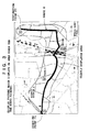
- Fig. 2 shows the regular display of a map without adding display control. Information "from the starting point P1 to the destination P2" is added to the map by a user and a route R is thereby displayed.
- the area having a predetermined width of the route R is displayed clearly and the other area is displayed less clearly by display control.
- the positional relationship of the route R can be specified by placing a station B within the predetermined width.
- the area having a predetermined width is widened.
- the entire positional relationship can be known clearly by placing stations A and B within the predetermined width.
- a map having high visibility can be displayed by changing the predetermined width as well as the display mode.
- the map display device having the function of detecting information on its position has: a map information database 11 for storing map information; a route specifying unit 12 as route specifying means for specifying a route on map information extracted from the map information database 11; a display control unit 13 as display control means for controlling to display the area having a predetermined width of the specified route clearly and the other area less clearly; a map display unit 14 for displaying the specified map information, the area having a predetermined width of the specified route clearly and the other area less clearly; and a position information detection unit 15 for detecting information on its position.
- the route specifying unit 12 sets a route by inputting the address of a destination or the name of a place using an unshown operation button or remote control.
- the display control unit 13 displays a desired map on the screen and controls to display the area having a predetermined width of the route specified by the route specifying unit 12 clearly and the other area less clearly.
- This area having a predetermined width can be set narrow or wide according to map information when it includes labyrinthine buildings or roads.
- the position information detection unit 15 has the function of detecting information on the position of the device, for example, GPS to detect information on the position of the device.
- the map display device constituted as described above displays a map which can display the detected information on its position on the screen of the map display unit 14 and specifies the route on the map displayed on the screen by operating the unshown operation button of the route specifying unit 12. Then, the area having a predetermined width of the specified route is displayed clearly and the other area is displayed less clearly.
- This display mode can be changed. That is, as shown in Fig. 3 and Fig. 4, the area of the route can be enlarged or reduced.
- the display control unit 13 specifies a particular point, for example, "A" in Fig. 3 on the displayed map, or specifies a landmark and displays the landmark clearly when the map is displayed previously, or changes the area of the route to an area including this landmark and displays it clearly.
- the predetermined area of the route can be displayed clearly.
- the area to be displayed clearly can be enlarged along with the movement of the device to follow the movement by making use of the function of detecting information on the position of the device.
- the device becomes easy to use and easy to see by enlarging the clearly displayed area in the moving direction of the moving device, preferably the area in front of the device in the moving direction, thereby improving visibility.
- the map display system has a map information server 21 which stores map information and can distribute it over a network, and browsers 23,...23 which receive map information over the network 22 such as Internet and comprise a map display unit for displaying the received map information.
- a map information server 21 which stores map information and can distribute it over a network
- browsers 23,...23 which receive map information over the network 22 such as Internet and comprise a map display unit for displaying the received map information.
- Each of the browsers 23 is a so-called map display device, can be implemented by a portable telephone, PDA, personal computer or the like and has a map information receiving unit 24 for receiving map information over the network 22, a route specifying unit 25 for specifying a route on the received map information, a display control unit 26 for displaying the area of the specified route clearly and the other area less clearly, and a map display unit 27 for displaying map information having the specified route.
- the browser 23 accesses the map information server 21 over the network to receive desired map information.
- the received map information is input into the map information receiving unit 24 and a route is specified by the operation of the browser 23.
- the display control unit 26 displays the area of the specified route clearly and the other area less clearly.
- the area having a predetermined width of this route can be suitably changed.
- This area of the route can be enlarged or reduced like the area shown in Fig. 3 and Fig. 4.
- the display control unit 26 changes the area having a predetermined width of the specified route to include a landmark existent in the vicinity of the route. For example, when “A” is displayed faintly in Fig. 3, the area is enlarged up to "A” to display "A" clearly.
- This landmark may be preset or may be set with reference to the displayed map.
- a landmark can be displayed clearly.
- the preset landmark or the set landmark is displayed clearly as well as the route, thereby making it easy to recognize the route and making it possible to improve visibility.
- the map display system having the function of detecting information on its position has a map information server 21 which stores map information and can distribute it over a network 22 such as Internet, and browsers 23A, ... 23A which receive map information over the network 22, have the function of detecting information on the position of the system and comprise a map display unit for displaying the received map information.
- a map information server 21 which stores map information and can distribute it over a network 22 such as Internet
- browsers 23A, ... 23A which receive map information over the network 22 have the function of detecting information on the position of the system and comprise a map display unit for displaying the received map information.
- Each of the browsers 23A is a so-called map display device, can be implemented by a portable telephone, PDA, personal computer or the like and has a map information receiving unit 24 for receiving map information over the network 22, a route specifying unit 25 for specifying a route on the received map information, a display control unit 26 for displaying the area of the specified route clearly and the other area less clearly, a map display unit 27 for displaying map information having the specified route, and a position information detection unit 28 capable of detecting information on the position of the system using GPS or the like.
- a map information receiving unit 24 for receiving map information over the network 22
- a route specifying unit 25 for specifying a route on the received map information
- a display control unit 26 for displaying the area of the specified route clearly and the other area less clearly
- a map display unit 27 for displaying map information having the specified route
- a position information detection unit 28 capable of detecting information on the position of the system using GPS or the like.
- the browser 23A accesses the map information server 21 over the network 22 to receive desired map information when a map is to be displayed.
- the received map information is input into the map information receiving unit 24 and a route is specified by the operation of the browser 23A.
- the display control unit 26 displays the area of the specified route clearly and the other area less clearly.
- the area having a predetermined width of the route can be suitably changed.
- This display mode is the same as in Fig. 3 and Fig. 4, and the area of the route can be enlarged or reduced.
- the map displayed on the screen is the map of the area including information on the position of the system, the position of the system can be displayed on the map.
- the display control unit 26 changes the area having a predetermined width of the specified route to an area including a landmark existent in the vicinity of the route. For example, when “A” is displayed faintly in Fig. 3, the area is enlarged up to "A” to display "A" clearly.
- This landmark can be preset or may be set with reference to the displayed map.
- a landmark can be displayed clearly.
- the preset landmark or the set landmark is displayed clearly as well as the route, thereby making it easy to recognize the route and making it possible to improve visibility.
- the browser 23A can display the predetermined area of the route clearly.
- the area to be displayed clearly can be unchanged or enlarged along with the movement of the system to follow the movement by making use of the function of detecting information on the position of the system.
- the device becomes easy to use and easy to see by enlarging the clearly displayed area in the moving direction of the moving system, preferably the area in front of the system in the moving direction, thereby improving visibility.
- the map display method and map display device display the specified route clearly, thereby making it easy to recognize the route without being bothered with the names of places and buildings included in the map.
Abstract
Description
- The present invention relates to a map display method, a map display device and a map display system and, specifically, to a map display method, a map display device and a map display system all of which improve the visibility of a route on a map displayed on a screen.
- As means of displaying map information in the prior art, in general, desired map information is displayed on a predetermined display device and enlarged or reduced, or the destination on the displayed map is enclosed with a square or specified by a pointer so that a user can easily recognize it.
- A technique of displaying a route on a map by inputting the address of a destination or the name of a place is widely and generally employed in car navigation systems making use of GPS (Global Positioning System).
- Although the route is shown on the map displayed on the screen in most cases as described in the prior art, there is a problem that when a lot of information such as the names of places and the names of buildings are shown on the map, it is difficult to recognize the route.
- It is therefore an object of at least preferred embodiments of the present invention to provide a map display method, device and system all of which improve the visibility of the specified route when the route is specified on the map.
- According to the present invention, the above object is addressed by a map display method, a map display device and a map display system constituted as described below.
- According to a first aspect of the present invention, there is provided a map display method having the steps of: displaying a predetermined map on a screen; specifying a route on the map displayed on the screen; and displaying the area having a predetermined width of the specified route clearly and the other area less clearly.
- According to a second aspect of the present invention, there is provided a map display method, wherein the area having a predetermined width of the route can be suitably changed.
- According to a third aspect of the present invention, there is provided a map display method, wherein the area having a predetermined width of the specified route is changed to include a landmark existent in the vicinity of the route.
- According to a fourth aspect of the present invention, there is provided a map display method, wherein the area having a predetermined width of the specified route is displayed clearly, the other area is displayed less clearly, and a landmark is displayed clearly.
- According to a fifth aspect of the present invention, there is provided a map display method having the steps of: detecting information on the position of a device and displaying a map capable of displaying the detected information on a screen; specifying a route on the map displayed on the screen; and displaying the area having a predetermined width of the specified route clearly and the other area less clearly.
- According to a sixth aspect of the present invention, there is provided a map display method, wherein the area having a predetermined width of the route can be suitably changed.
- According to a seventh aspect of the present invention, there is provided a map display method, wherein the area having a predetermined width of the specified route is changed to include a landmark existent in the vicinity of the route.
- According to an eighth aspect of the present invention, there is provided a map display method, wherein the area having a predetermined width of the specified route is displayed clearly, the other area is displayed less clearly, and a landmark is displayed clearly.
- According to a ninth aspect of the present invention, there is provided a map display method, wherein when a device is moved along the route, the area having a predetermined width of the route is enlarged along with the movement.
- According to a tenth aspect of the present invention, there is provided a map display device having: map display means capable of displaying a predetermined map on a screen; route specifying means for specifying a route on the map displayed on the screen; and display control means for displaying the area having a predetermined width of the specified route clearly and the other area less clearly.
- According to an eleventh aspect of the present invention, there is provided a map display device, wherein the display control means can change the area having a predetermined width of the route suitably.
- According to a twelfth aspect of the present invention, there is provided a map display device, wherein the display control means changes the area having a predetermined width of the specified route to include a landmark existent in the vicinity of the route.
- According to a thirteenth aspect of the present invention, there is provided a map display device, wherein the display control means displays the area having a predetermined width of the specified route clearly, the other area less clearly and a landmark clearly.
- According to a fourteenth aspect of the present invention, there is provided a map display device having: map display means for detecting information on the position of the device and displaying a map capable of displaying the detected information on a screen; route specifying means for specifying a route on the map displayed on the screen; and display control means for displaying the area having a predetermined width of the specified route clearly and the other area less clearly.
- According to a fifteenth aspect of the present invention, there is provided a map display device, wherein the display control means can change the area having a predetermined width of the route suitably.
- According to a sixteenth aspect of the present invention, there is provided a map display device, wherein the display control means changes the area having a predetermined width of the specified route to include a landmark existent in the vicinity of the route.
- According to a seventeenth aspect of the present invention, there is provided a map display device, wherein the display control means displays the area having a predetermined width of the specified route clearly, the other area less clearly and a landmark clearly.
- According to an eighteenth aspect of the present invention, there is provided a map display device, wherein the display control means enlarges and moves the area having a predetermined width of the route with the movement of the device along the route.
- According to a nineteenth aspect of the present invention, there is provided a map display system having: a map information server which stores map information and can distribute it over a network; and browsers which receive map information over the network and have a map display unit for displaying the received map information, each of the browsers having : map information receiving means for receiving map information over the network; route specifying means for specifying a route on the received map information; display control means for displaying the area of the specified route clearly and the other area less clearly; and map display means for displaying map information having the specified route.
- According to a twentieth aspect of the present invention, there is provided a map display system, wherein the display control means can change the area having a predetermined width of the route suitably.
- According to a twenty-first aspect of the present invention, there is provided a map display system, wherein the display control means changes the area having a predetermined width of the specified route to include a landmark existent in the vicinity of the route.
- According to a twenty-second aspect of the present invention, there is provided a map display system, wherein the display control means displays the area having a predetermined width of the specified route clearly, the other area less clearly and a landmark clearly.
- According to a twenty- third aspect of the present invention, there is provided a map display system having: a map information server which stores map information and can distribute it over a network; and browsers which receive map information over the network and have a map display unit for displaying the received map information,
each of the browsers having: map information receiving means for receiving map information over the network; map display means for detecting information on the position of the system and displaying a map capable of displaying the detected information on a screen; route specifying means for specifying a route on the map displayed on the screen; and display control means for displaying the area having a predetermined width of the specified route clearly and the other area less clearly. - According to a twenty- fourth aspect of the present invention, there is provided a map display system, wherein the display control means can change the area having a predetermined width of the route suitably.
- According to a twenty-fifth aspect of the present invention, there is provided a map display system, wherein the display control means changes the area having a predetermined width of the specified route to include a landmark existent in the vicinity of the route.
- According to a twenty-sixth aspect of the present invention, there is provided a map display system, wherein the display control means displays the area having a predetermined width of the specified route clearly, the other area less clearly and a landmark clearly.
- According to a twenty-seventh aspect of the present invention, there is provided a map display system, wherein the display control means enlarges and moves the area having a predetermined width of the route with the movement of the system along the route.
- Thus, when a route is input into the map displayed on the screen, the area having a predetermined width of the route is displayed clearly and the other area is displayed less clearly, thereby making it easy to see the desired route and making it possible to improve visibility.
- In a system having a screen having the function of detecting information on its position and capable of displaying a map, when a route is specified, the display of information on its position and the area having a predetermined width of the route is changed to make it easy to see the map while moving and improve the visibility of the route.
- Embodiments of the invention will now be described, by way of example only, with reference to the accompanying drawings in which:
- Fig. 1 is a schematic whole structural diagram of a map display device according to an example embodiment of the present invention;
- Fig. 2 is a diagram of a sample of a regular route display picture displayed on the screen of the device of Fig. 1;
- Fig. 3 is a diagram of a sample which displays the route in Fig. 2 and its vicinity clearly and the other area less clearly;
- Fig. 4 is a diagram of a sample which changes the display mode of Fig. 3;
- Fig. 5 is a schematic whole structural diagram of a map display device according to another example embodiment of the present invention;
- Fig. 6 is a schematic whole structural diagram of a map display system according to an example embodiment of the present invention; and
- Fig. 7 is a schematic whole structural diagram of a map display system according to another example embodiment of the present invention;
-
- A map display method, a map display device and a map display system according to preferred embodiments of the present invention will be described hereinunder with reference to the accompanying drawings.
- A map display device which can carry out the map display method of the present invention has: a
map information database 11 for storing map information; aroute specifying unit 12 as route specifying means for specifying a route on map information extracted from themap information database 11; adisplay control unit 13 as display control means for controlling to display the area having a predetermined width of the specified route clearly and the other area less clearly; and amap display unit 14 for displaying the specified map information, the area having a predetermined width of the specified route clearly and the other area less clearly. - The area of the route can be displayed clearly by controlling the display screen of the device, setting the screen bright in advance, or directly without controlling the screen.
- The control of the display screen to display the other area less clearly is to display the other area faintly to such an extent that it is difficult to see, it is indistinct, it can hardly be seen, it cannot be completely seen, or the like.
- In short, the area having a predetermined width of the specified route and the other area are displayed in such a manner that they can be distinguished from each other in order to improve the visibility of the route.
- The
route specifying unit 12 sets a route by inputting the address of a destination or the name of a place using an unshown operation button or remote control. - The
display control unit 13 controls to display the area having a predetermined width of the route specified by theroute specifying unit 12 clearly and the other area less clearly. This area having a predetermined width can be made narrow or wide according to map information when it includes labyrinthine buildings or roads. - This will be described with reference to drawings. Fig. 2 shows the regular display of a map without adding display control. Information "from the starting point P1 to the destination P2" is added to the map by a user and a route R is thereby displayed.
- On the map of Fig. 3, the area having a predetermined width of the route R is displayed clearly and the other area is displayed less clearly by display control. The positional relationship of the route R can be specified by placing a station B within the predetermined width.
- On the map of Fig. 4, the area having a predetermined width is widened. The entire positional relationship can be known clearly by placing stations A and B within the predetermined width.
- Thus, a map having high visibility can be displayed by changing the predetermined width as well as the display mode.
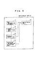
- Another embodiment of a map display device having the function of detecting information on its position will be described with reference to the accompanying drawing.
- As shown in Fig. 5, the map display device having the function of detecting information on its position has: a
map information database 11 for storing map information; aroute specifying unit 12 as route specifying means for specifying a route on map information extracted from themap information database 11; adisplay control unit 13 as display control means for controlling to display the area having a predetermined width of the specified route clearly and the other area less clearly; amap display unit 14 for displaying the specified map information, the area having a predetermined width of the specified route clearly and the other area less clearly; and a positioninformation detection unit 15 for detecting information on its position. - The
route specifying unit 12 sets a route by inputting the address of a destination or the name of a place using an unshown operation button or remote control. - The
display control unit 13 displays a desired map on the screen and controls to display the area having a predetermined width of the route specified by theroute specifying unit 12 clearly and the other area less clearly. This area having a predetermined width can be set narrow or wide according to map information when it includes labyrinthine buildings or roads. - The position
information detection unit 15 has the function of detecting information on the position of the device, for example, GPS to detect information on the position of the device. - The map display device constituted as described above displays a map which can display the detected information on its position on the screen of the
map display unit 14 and specifies the route on the map displayed on the screen by operating the unshown operation button of theroute specifying unit 12. Then, the area having a predetermined width of the specified route is displayed clearly and the other area is displayed less clearly. This display mode can be changed. That is, as shown in Fig. 3 and Fig. 4, the area of the route can be enlarged or reduced. - The
display control unit 13 specifies a particular point, for example, "A" in Fig. 3 on the displayed map, or specifies a landmark and displays the landmark clearly when the map is displayed previously, or changes the area of the route to an area including this landmark and displays it clearly. - When a particular route is specified on the map displayed on the screen, the predetermined area of the route can be displayed clearly. In this embodiment, when the device is moved along the specified route, the area to be displayed clearly can be enlarged along with the movement of the device to follow the movement by making use of the function of detecting information on the position of the device. Thus, the device becomes easy to use and easy to see by enlarging the clearly displayed area in the moving direction of the moving device, preferably the area in front of the device in the moving direction, thereby improving visibility.
- A description is subsequently given of an embodiment of a map display system using this map display device with reference to the accompanying drawing.
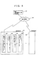
- As shown in Fig. 6, the map display system has a
map information server 21 which stores map information and can distribute it over a network, andbrowsers 23,...23 which receive map information over thenetwork 22 such as Internet and comprise a map display unit for displaying the received map information. - Each of the
browsers 23 is a so-called map display device, can be implemented by a portable telephone, PDA, personal computer or the like and has a mapinformation receiving unit 24 for receiving map information over thenetwork 22, aroute specifying unit 25 for specifying a route on the received map information, adisplay control unit 26 for displaying the area of the specified route clearly and the other area less clearly, and amap display unit 27 for displaying map information having the specified route. - In this constitution, when a map is to be displayed, the
browser 23 accesses themap information server 21 over the network to receive desired map information. The received map information is input into the mapinformation receiving unit 24 and a route is specified by the operation of thebrowser 23. - When the route is specified, the
display control unit 26 displays the area of the specified route clearly and the other area less clearly. The area having a predetermined width of this route can be suitably changed. This area of the route can be enlarged or reduced like the area shown in Fig. 3 and Fig. 4. - The
display control unit 26 changes the area having a predetermined width of the specified route to include a landmark existent in the vicinity of the route. For example, when "A" is displayed faintly in Fig. 3, the area is enlarged up to "A" to display "A" clearly. This landmark may be preset or may be set with reference to the displayed map. - Further, instead that the area having a predetermined width of the specified route is displayed clearly and the other area is displayed less clearly, a landmark can be displayed clearly. When the device is controlled as described above, the preset landmark or the set landmark is displayed clearly as well as the route, thereby making it easy to recognize the route and making it possible to improve visibility.
- A description is subsequently given of another embodiment of a map display system having the function of detecting information on its position with reference to the accompanying drawing.
- As shown in Fig. 7, the map display system having the function of detecting information on its position has a
map information server 21 which stores map information and can distribute it over anetwork 22 such as Internet, andbrowsers 23A, ... 23A which receive map information over thenetwork 22, have the function of detecting information on the position of the system and comprise a map display unit for displaying the received map information. - Each of the
browsers 23A is a so-called map display device, can be implemented by a portable telephone, PDA, personal computer or the like and has a mapinformation receiving unit 24 for receiving map information over thenetwork 22, aroute specifying unit 25 for specifying a route on the received map information, adisplay control unit 26 for displaying the area of the specified route clearly and the other area less clearly, amap display unit 27 for displaying map information having the specified route, and a positioninformation detection unit 28 capable of detecting information on the position of the system using GPS or the like. - In this constitution, the
browser 23A accesses themap information server 21 over thenetwork 22 to receive desired map information when a map is to be displayed. The received map information is input into the mapinformation receiving unit 24 and a route is specified by the operation of thebrowser 23A. - When the route is specified, the
display control unit 26 displays the area of the specified route clearly and the other area less clearly. The area having a predetermined width of the route can be suitably changed. This display mode is the same as in Fig. 3 and Fig. 4, and the area of the route can be enlarged or reduced. When the map displayed on the screen is the map of the area including information on the position of the system, the position of the system can be displayed on the map. - The
display control unit 26 changes the area having a predetermined width of the specified route to an area including a landmark existent in the vicinity of the route. For example, when "A" is displayed faintly in Fig. 3, the area is enlarged up to "A" to display "A" clearly. This landmark can be preset or may be set with reference to the displayed map. - Further, instead that the area having a predetermined width of the specified route is displayed clearly and the other area is displayed less clearly, a landmark can be displayed clearly. When the device is controlled as described above, the preset landmark or the set landmark is displayed clearly as well as the route, thereby making it easy to recognize the route and making it possible to improve visibility.
- When a particular route is specified on the map displayed on the screen, the
browser 23A can display the predetermined area of the route clearly. In this embodiment, when the system is moved along the specified route, the area to be displayed clearly can be unchanged or enlarged along with the movement of the system to follow the movement by making use of the function of detecting information on the position of the system. Thereby, the device becomes easy to use and easy to see by enlarging the clearly displayed area in the moving direction of the moving system, preferably the area in front of the system in the moving direction, thereby improving visibility. - As described above, when a route is specified on the displayed map, the map display method and map display device according to the present invention display the specified route clearly, thereby making it easy to recognize the route without being bothered with the names of places and buildings included in the map.
- In so far as the embodiments of the invention described above are implemented, at least in part, using software-controlled data processing apparatus, it will be appreciated that a computer program providing such software control and a storage medium by which such a computer program is stored are envisaged as aspects of the present invention.
- The foregoing invention has been described in terms of preferred embodiments. However, those skilled, in the art will recognize that many variations of such embodiments exist. Such variations are intended to be within the scope of the present invention and the appended claims.
Claims (27)
- A map display method comprising the steps of:displaying a predetermined map on a screen;specifying a route on the map displayed on the screen; anddisplaying the area having a predetermined width of the specified route clearly and the other area less clearly.
- The map display method of claim 1, wherein the area having a predetermined width of the route can be suitably changed.
- The map display method of claim 1, wherein the area having a predetermined width of the specified route is changed to include a landmark existent in the vicinity of the route.
- The map display method of claim 1, wherein the area having a predetermined width of the specified route is displayed clearly, the other area is displayed less clearly, and a landmark is displayed clearly.
- A map display method comprising the steps of:detecting information on the position of a device and displaying a map capable of displaying the detected information on a screen;specifying a route on the map displayed on the screen; anddisplaying the area having a predetermined width of the specified route clearly and the other area less clearly.
- The map display method of claim 5, wherein the area having a predetermined width of the route can be suitably changed.
- The map display method of claim 5, wherein the area having a predetermined width of the specified route is changed to include a landmark existent in the vicinity of the route.
- The map display method of claim 5, wherein the area having a predetermined width of the specified route is displayed clearly, the other area is displayed less clearly, and a landmark is displayed clearly.
- The map display method of claim 5, wherein when a device is moved along the route, the area having a predetermined width of the route is enlarged along with the movement.
- A map display device comprising:map display means capable of displaying a predetermined map on a screen;route specifying means for specifying a route on the map displayed on the screen; and
display control means for displaying the area having a predetermined width of the specified route clearly and the other area less clearly. - The map display device of claim 10, wherein the display control means can change the area having a predetermined width of the route suitably.
- The map display device of claim 10, wherein the display control means changes the area having a predetermined width of the specified route to include a landmark existent in the vicinity of the route.
- The map display device of claim 10, wherein the display control means displays the area having a predetermined width of the specified route clearly, the other area less clearly and a landmark clearly.
- A map display device comprising:map display means for detecting information on the position of the device and displaying a map capable of displaying the detected information on a screen;route specifying means for specifying a route on the map displayed on the screen; and
display control means for displaying the area having a predetermined width of the specified route clearly and the other area less clearly. - The map display device of claim 14, wherein the display control means can change the area having a predetermined width of the route suitably.
- The map display device of claim 14, wherein the display control means changes the area having a predetermined width of the specified route to include a landmark existent in the vicinity of the route.
- The map display device of claim 14, wherein the display control means displays the area having a predetermined width of the specified route clearly, the other area less clearly and a landmark clearly.
- The map display device of claim 14, wherein the display control means enlarges and moves the area having a predetermined width of the route with the movement of the device along the route.
- A map display system comprising:a map information server which stores map information and can distribute it over a network; andbrowsers which receive map information over the network and have a map display unit for displaying the received map information, each of the browsers comprising:map information receiving means for receiving map information over the network;route specifying means for specifying a route on the received map information;display control means for displaying the area of the specified route clearly and the other area less clearly; andmap display means for displaying map information having the specified route.
- The map display system of claim 19, wherein the display control means can change the area having a predetermined width of the route suitably.
- The map display system of claim 19, wherein the display control means changes the area having a predetermined width of the specified route to include a landmark existent in the vicinity of the route.
- The map display system of claim 19, wherein the display control means displays the area having a predetermined width of the specified route clearly, the other area less clearly and a landmark clearly.
- A map display system comprising:a map information server which stores map information and can distribute it over a network; andbrowsers which receive map information over the network and have a map display unit for displaying the received map information, each of the browsers comprising:map information receiving means for receiving map information over the network;map display means for detecting information on the position of the system and displaying a map capable of displaying the detected information on a screen;route specifying means for specifying a route on the map displayed on the screen; anddisplay control means for displaying the area having a predetermined width of the specified route clearly and the other area less clearly.
- The map display system of claim 23, wherein the display control means can change the area having a predetermined width of the route suitably.
- The map display system of claim 23, wherein the display control means changes the area having a predetermined width of the specified route to include a landmark existent in the vicinity of the route.
- The map display system of claim 23, wherein the display control means displays the area having a predetermined width of the specified route clearly, the other area less clearly and a landmark clearly.
- The map display system of claim 23, wherein the display control means enlarges and moves the area having a predetermined width of the route with the movement of the system along the route.
Applications Claiming Priority (2)
| Application Number | Priority Date | Filing Date | Title |
|---|---|---|---|
| JP2001246593A JP2003057045A (en) | 2001-08-15 | 2001-08-15 | Method, apparatus and system for display of map |
| JP2001246593 | 2001-08-15 |
Publications (2)
| Publication Number | Publication Date |
|---|---|
| EP1284410A2 true EP1284410A2 (en) | 2003-02-19 |
| EP1284410A3 EP1284410A3 (en) | 2004-08-25 |
Family
ID=19076106
Family Applications (1)
| Application Number | Title | Priority Date | Filing Date |
|---|---|---|---|
| EP02255484A Withdrawn EP1284410A3 (en) | 2001-08-15 | 2002-08-06 | Map display method, map display device and map display system |
Country Status (3)
| Country | Link |
|---|---|
| US (1) | US7082571B2 (en) |
| EP (1) | EP1284410A3 (en) |
| JP (1) | JP2003057045A (en) |
Cited By (4)
| Publication number | Priority date | Publication date | Assignee | Title |
|---|---|---|---|---|
| DE102005020154A1 (en) * | 2005-04-29 | 2006-11-02 | Volkswagen Ag | Map display control method, used in navigation system, involves displaying section of geographical road map, dividing displayed map section into different areas, and displaying assigned road classes in divided areas of displayed map section |
| EP2034274A1 (en) * | 2007-09-07 | 2009-03-11 | Robert Bosch Gmbh | Map display device and corresponding method |
| EP2578998A1 (en) * | 2010-05-24 | 2013-04-10 | Mitsubishi Electric Corporation | Navigation system |
| DE102013212968A1 (en) * | 2013-07-03 | 2015-01-08 | Bayerische Motoren Werke Aktiengesellschaft | Representation of a road environment for driving maneuvers of a vehicle |
Families Citing this family (12)
| Publication number | Priority date | Publication date | Assignee | Title |
|---|---|---|---|---|
| EP1612632B1 (en) * | 2004-07-03 | 2009-01-07 | Saab Ab | A system and method for in-flight control of an aerial vehicle |
| US7861183B2 (en) * | 2004-07-20 | 2010-12-28 | Panasonic Corporation | Guidance display device |
| JP2006039237A (en) * | 2004-07-28 | 2006-02-09 | Nippon Seiki Co Ltd | Display apparatus |
| US7480514B2 (en) * | 2005-01-26 | 2009-01-20 | Broadcom Corporation | GPS enabled cell phone with compass mode mapping function |
| US20070131754A1 (en) * | 2005-12-12 | 2007-06-14 | Brandon Frank L | Method and system of collecting data using unmanned vehicles having releasable data storage devices |
| US20090112455A1 (en) * | 2007-10-24 | 2009-04-30 | Yahoo! Inc. | Method and system for rendering simplified point finding maps |
| WO2009132676A1 (en) | 2008-05-02 | 2009-11-05 | Tom Tom International B.V. | A navigation device and method for emphasising a map route |
| DE102012213307A1 (en) * | 2012-07-30 | 2014-01-30 | Robert Bosch Gmbh | Method for determining representation of label elements of digital card using navigation system of vehicle e.g. passenger car, involves selecting representation modes to represent active and inactive label elements within digital card |
| JP6037758B2 (en) * | 2012-10-15 | 2016-12-07 | 株式会社ゼンリンデータコム | Guide map creation device, guide map creation method, and guide map creation program |
| JP6485701B2 (en) * | 2015-08-24 | 2019-03-20 | コニカミノルタ株式会社 | Program job editing device |
| CN108267152B (en) * | 2016-12-31 | 2020-11-10 | 中国移动通信集团辽宁有限公司 | Method and device for determining navigation map |
| JP6979141B1 (en) | 2020-01-31 | 2021-12-08 | 株式会社 ミックウェア | Display device and control program |
Citations (4)
| Publication number | Priority date | Publication date | Assignee | Title |
|---|---|---|---|---|
| JPH06331371A (en) * | 1993-05-25 | 1994-12-02 | Toshiba Corp | Road information display device |
| US5471205A (en) * | 1994-08-31 | 1995-11-28 | Izawa; Michio | Map displaying method |
| US5802492A (en) * | 1994-06-24 | 1998-09-01 | Delorme Publishing Company, Inc. | Computer aided routing and positioning system |
| JP2000180192A (en) * | 1998-12-10 | 2000-06-30 | Aisin Aw Co Ltd | Map guide display apparatus and record medium |
Family Cites Families (5)
| Publication number | Priority date | Publication date | Assignee | Title |
|---|---|---|---|---|
| US6133853A (en) * | 1998-07-30 | 2000-10-17 | American Calcar, Inc. | Personal communication and positioning system |
| JP3548459B2 (en) * | 1998-11-20 | 2004-07-28 | 富士通株式会社 | Guide information presenting apparatus, guide information presenting processing method, recording medium recording guide information presenting program, guide script generating apparatus, guide information providing apparatus, guide information providing method, and guide information providing program recording medium |
| JP3587691B2 (en) * | 1998-07-30 | 2004-11-10 | 日本電信電話株式会社 | Navigation method and apparatus, and recording medium recording program for processing this method |
| JP3596805B2 (en) * | 1999-07-29 | 2004-12-02 | 松下電器産業株式会社 | Information terminal device and route guidance method |
| US6892135B1 (en) * | 2001-12-21 | 2005-05-10 | Garmin Ltd. | Navigation system, method and device with automatic next turn page |
-
2001
- 2001-08-15 JP JP2001246593A patent/JP2003057045A/en active Pending
-
2002
- 2002-08-06 EP EP02255484A patent/EP1284410A3/en not_active Withdrawn
- 2002-08-13 US US10/218,208 patent/US7082571B2/en not_active Expired - Fee Related
Patent Citations (4)
| Publication number | Priority date | Publication date | Assignee | Title |
|---|---|---|---|---|
| JPH06331371A (en) * | 1993-05-25 | 1994-12-02 | Toshiba Corp | Road information display device |
| US5802492A (en) * | 1994-06-24 | 1998-09-01 | Delorme Publishing Company, Inc. | Computer aided routing and positioning system |
| US5471205A (en) * | 1994-08-31 | 1995-11-28 | Izawa; Michio | Map displaying method |
| JP2000180192A (en) * | 1998-12-10 | 2000-06-30 | Aisin Aw Co Ltd | Map guide display apparatus and record medium |
Non-Patent Citations (2)
| Title |
|---|
| PATENT ABSTRACTS OF JAPAN vol. 1995, no. 03, 28 April 1995 (1995-04-28) & JP 6 331371 A (TOSHIBA CORP), 2 December 1994 (1994-12-02) * |
| PATENT ABSTRACTS OF JAPAN vol. 2000, no. 09, 13 October 2000 (2000-10-13) & JP 2000 180192 A (AISIN AW CO LTD; TOYOTA MOTOR CORP; DENSO CORP; FUJITSU TEN LTD; MATSU), 30 June 2000 (2000-06-30) * |
Cited By (6)
| Publication number | Priority date | Publication date | Assignee | Title |
|---|---|---|---|---|
| DE102005020154A1 (en) * | 2005-04-29 | 2006-11-02 | Volkswagen Ag | Map display control method, used in navigation system, involves displaying section of geographical road map, dividing displayed map section into different areas, and displaying assigned road classes in divided areas of displayed map section |
| EP2034274A1 (en) * | 2007-09-07 | 2009-03-11 | Robert Bosch Gmbh | Map display device and corresponding method |
| EP2578998A1 (en) * | 2010-05-24 | 2013-04-10 | Mitsubishi Electric Corporation | Navigation system |
| EP2578998A4 (en) * | 2010-05-24 | 2015-01-07 | Mitsubishi Electric Corp | Navigation system |
| US9057623B2 (en) | 2010-05-24 | 2015-06-16 | Mitsubishi Electric Corporation | Navigation device |
| DE102013212968A1 (en) * | 2013-07-03 | 2015-01-08 | Bayerische Motoren Werke Aktiengesellschaft | Representation of a road environment for driving maneuvers of a vehicle |
Also Published As
| Publication number | Publication date |
|---|---|
| EP1284410A3 (en) | 2004-08-25 |
| JP2003057045A (en) | 2003-02-26 |
| US7082571B2 (en) | 2006-07-25 |
| US20030036846A1 (en) | 2003-02-20 |
Similar Documents
| Publication | Publication Date | Title |
|---|---|---|
| EP1284410A2 (en) | Map display method, map display device and map display system | |
| US8175803B2 (en) | Graphic interface method and apparatus for navigation system for providing parking information | |
| EP2075545B1 (en) | Navigation apparatus and method of providing information on points of interest | |
| US7590487B2 (en) | Method and apparatus of displaying three-dimensional arrival screen for navigation system | |
| US7783421B2 (en) | Navigation device, navigation method, navigation program, server device, and navigation information distribution system | |
| US8103439B2 (en) | Portable navigation terminal and program | |
| US7519469B2 (en) | Display method and apparatus for navigation system | |
| US9122382B2 (en) | Method for selecting target at touch point on touch screen of mobile device | |
| EP2280244B1 (en) | Method for simulating navigation route, navigation apparatus and computer program product | |
| JP2004272217A (en) | Map image display controlling method, its program, storage medium for storing the program and electronic equipment | |
| US20090088964A1 (en) | Map scrolling method and apparatus for navigation system for selectively displaying icons | |
| JP2002206933A (en) | Method of displaying poi icon for navigation system | |
| JP2005083941A (en) | Guide information providing device and program | |
| JP2007071587A (en) | Navigation device and scrolling method of map | |
| JP2008027287A (en) | Map display system, map display device, map display method and map distribution server | |
| JP5328280B2 (en) | Navigation device | |
| JP2008082818A (en) | Navigation system and navigation device | |
| EP2058778B1 (en) | System and method for providing dynamic route information to users of wireless communications devices | |
| JP2001336948A (en) | Information displaying method using network and its system | |
| JP2007256020A (en) | Navigation device, navigation method, and navigation program | |
| JP4358882B2 (en) | Map display system, map display device, and map display method | |
| KR20130052962A (en) | Navigation apparatus and control method of the same | |
| JP3233443B2 (en) | Map display device | |
| JP2003075189A (en) | Information providing system, display program, information providing device, and portable terminal | |
| EP2249125A1 (en) | Map drawing device |
Legal Events
| Date | Code | Title | Description |
|---|---|---|---|
| PUAI | Public reference made under article 153(3) epc to a published international application that has entered the european phase |
Free format text: ORIGINAL CODE: 0009012 |
|
| AK | Designated contracting states |
Designated state(s): AT BE BG CH CY CZ DE DK EE ES FI FR GB GR IE IT LI LU MC NL PT SE SK TR |
|
| AX | Request for extension of the european patent |
Extension state: AL LT LV MK RO SI |
|
| PUAL | Search report despatched |
Free format text: ORIGINAL CODE: 0009013 |
|
| AK | Designated contracting states |
Kind code of ref document: A3 Designated state(s): AT BE BG CH CY CZ DE DK EE ES FI FR GB GR IE IT LI LU MC NL PT SE SK TR |
|
| AX | Request for extension of the european patent |
Extension state: AL LT LV MK RO SI |
|
| 17P | Request for examination filed |
Effective date: 20050204 |
|
| AKX | Designation fees paid |
Designated state(s): DE FR GB |
|
| RBV | Designated contracting states (corrected) |
Designated state(s): DE FR GB |
|
| 17Q | First examination report despatched |
Effective date: 20060412 |
|
| STAA | Information on the status of an ep patent application or granted ep patent |
Free format text: STATUS: THE APPLICATION IS DEEMED TO BE WITHDRAWN |
|
| 18D | Application deemed to be withdrawn |
Effective date: 20070301 |