EP1318381A2 - Method and system for interfacing a global positioning system, other navigational equipment and wireless networks with a digital data network - Google Patents
Method and system for interfacing a global positioning system, other navigational equipment and wireless networks with a digital data network Download PDFInfo
- Publication number
- EP1318381A2 EP1318381A2 EP02258445A EP02258445A EP1318381A2 EP 1318381 A2 EP1318381 A2 EP 1318381A2 EP 02258445 A EP02258445 A EP 02258445A EP 02258445 A EP02258445 A EP 02258445A EP 1318381 A2 EP1318381 A2 EP 1318381A2
- Authority
- EP
- European Patent Office
- Prior art keywords
- network
- data
- vehicle
- digital data
- wireless
- Prior art date
- Legal status (The legal status is an assumption and is not a legal conclusion. Google has not performed a legal analysis and makes no representation as to the accuracy of the status listed.)
- Withdrawn
Links
Images


Classifications
-
- G—PHYSICS
- G01—MEASURING; TESTING
- G01S—RADIO DIRECTION-FINDING; RADIO NAVIGATION; DETERMINING DISTANCE OR VELOCITY BY USE OF RADIO WAVES; LOCATING OR PRESENCE-DETECTING BY USE OF THE REFLECTION OR RERADIATION OF RADIO WAVES; ANALOGOUS ARRANGEMENTS USING OTHER WAVES
- G01S19/00—Satellite radio beacon positioning systems; Determining position, velocity or attitude using signals transmitted by such systems
- G01S19/38—Determining a navigation solution using signals transmitted by a satellite radio beacon positioning system
- G01S19/39—Determining a navigation solution using signals transmitted by a satellite radio beacon positioning system the satellite radio beacon positioning system transmitting time-stamped messages, e.g. GPS [Global Positioning System], GLONASS [Global Orbiting Navigation Satellite System] or GALILEO
- G01S19/53—Determining attitude
-
- G—PHYSICS
- G01—MEASURING; TESTING
- G01C—MEASURING DISTANCES, LEVELS OR BEARINGS; SURVEYING; NAVIGATION; GYROSCOPIC INSTRUMENTS; PHOTOGRAMMETRY OR VIDEOGRAMMETRY
- G01C21/00—Navigation; Navigational instruments not provided for in groups G01C1/00 - G01C19/00
- G01C21/26—Navigation; Navigational instruments not provided for in groups G01C1/00 - G01C19/00 specially adapted for navigation in a road network
- G01C21/28—Navigation; Navigational instruments not provided for in groups G01C1/00 - G01C19/00 specially adapted for navigation in a road network with correlation of data from several navigational instruments
-
- G—PHYSICS
- G01—MEASURING; TESTING
- G01S—RADIO DIRECTION-FINDING; RADIO NAVIGATION; DETERMINING DISTANCE OR VELOCITY BY USE OF RADIO WAVES; LOCATING OR PRESENCE-DETECTING BY USE OF THE REFLECTION OR RERADIATION OF RADIO WAVES; ANALOGOUS ARRANGEMENTS USING OTHER WAVES
- G01S19/00—Satellite radio beacon positioning systems; Determining position, velocity or attitude using signals transmitted by such systems
- G01S19/01—Satellite radio beacon positioning systems transmitting time-stamped messages, e.g. GPS [Global Positioning System], GLONASS [Global Orbiting Navigation Satellite System] or GALILEO
- G01S19/13—Receivers
- G01S19/35—Constructional details or hardware or software details of the signal processing chain
Definitions
- the present invention relates to the field of navigation in a motorized vehicle.
- the present invention also relates to the field of wireless communication of voice and data streams.
- the present invention also relates to the field of distributing data over a digital data network. More particularly, the present invention relates to a means and method of interfacing navigational equipment, such as a Global Positioning System (GPS), and wireless voice and data networks with a wired, digital data network installed in a vehicle so that data from the navigational equipment and wireless networks can be distributed and used by devices on the in-vehicle network.
- GPS Global Positioning System
- GPS Global Positioning Systems
- a GPS unit can define its location in terms of latitude and longitude anywhere in the world.
- GPS units are commonly used in motorized vehicles: cars, trucks, buses, boats, ships, aircraft, etc. With the information from an on-board GPS unit, and a review of how that information changes over time, a vehicle's direction or heading, velocity and other parameters can be determined. Additionally, other navigational equipment can be used to supplement the data generated by a GPS unit.
- GPS units are also often integrated with an electronic mapping system.
- the mapping system may include a display device on which a map of the user's locality is displayed. With the GPS data, the position of the user or the user's vehicle can be illustrated on the displayed map to assist a user in finding his or her way to a destination that is also mapped.
- the mapping system may also be able to generate directions or prompts based on a designated destination and the user's current location as identified by the GPS data.
- Wireless telephones operate by transmitting radio frequency (RF) signals between the user's handset unit and a network of base stations distributed throughout a service area.
- RF radio frequency
- These wireless networks sometimes referred to as Wireless Wide-Area Networks (WWANs) can be used to transmit data as well as voice to and from the user's location.
- WWANs Wireless Wide-Area Networks
- WLANs Wireless Local-Area Networks
- WLANs may exist, for example, in a particular building, among a complex of buildings, in a particular neighborhood or business district, etc.
- WLANs can also be used for carrying data, including voice data, to and from a user's registered wireless device.
- WPAN Wireless Personal Area Network
- These networks can connect cellphones, headphones, personal digital assistants and other information devices over a limited range.
- GPS and other navigational equipment help a user to constantly identify his or her position and navigate to a desired destination
- wireless networks and the devices that communicate with those networks allow the user to remain in voice and data communication while traveling. Consequently, a natural environment for the use of both GPS and wireless communications is in a user's vehicle.
- the present invention meets the above-described needs and others. Specifically, the present invention provides an improved means and method of integrating GPS and wireless communication systems with the systems of a user's vehicle so as to make the GPS and wireless communication systems more readily and safely accessible to the vehicle operator during travel.
- the present invention may be embodied and described as a navigational system for a vehicle having: a GPS receiver; a digital data network installed in the vehicle; and a network interface connecting the GPS receiver and the digital data network.
- the GPS receiver outputs navigational data on the digital data network.
- the present invention may provide a wireless communication system for a vehicle having: a wireless network stage with an antenna for communicating with a wireless network that has a service area in which the vehicle is located; a digital data network installed in the vehicle; and a digital network interface connecting the wireless network stage to the digital data network so that data received via the wireless network stage can be transmitted over the digital data network and data from the digital data network can be transmitted to the wireless network via the wireless network stage.
- the present invention also encompasses an embodiment that combines these two systems.
- the present invention may be embodied as a navigational and communications system for a vehicle having: a GPS receiver; a wireless network stage with an antenna for communicating with a wireless network that has a service area in which the vehicle is located; a digital data network installed in the vehicle; and a digital network interface connecting the wireless network stage and the GPS receiver to the digital data network.
- Data received via the wireless network stage can be transmitted over the digital data network and data from the digital data network can be transmitted to the wireless network via the wireless network stage.
- the GPS receiver also outputs navigational data on the digital data network.
- the present invention also encompasses the methods of making and operating the systems that embody the present invention.
- the present invention encompasses a method of providing navigational data in a vehicle by connecting a GPS receiver through a network interface to a digital data network installed in the vehicle such that the GPS receiver will output navigational data on the digital data network.
- the present invention also encompasses a method of providing wireless communications in a vehicle by providing a wireless network stage for communicating with a wireless network that has a service area in which the vehicle is located; and providing a connection between the wireless network stage and a digital data network installed in the vehicle.
- the present invention encompasses a method of providing wireless communications between devices inside the vehicle, and providing a connection between the wireless network stage and a digital network installed in the vehicle.
- the present invention also encompasses a method of providing navigational and communication systems for a vehicle by connecting a GPS receiver through a network interface to a digital data network installed in the vehicle such that the GPS receiver will output navigational data on the digital data network; providing a wireless network stage for communicating with a wireless network that has a service area in which the vehicle is located; and providing a connection between the wireless network stage and the digital data network installed in the vehicle.
- Fig. I is an illustration of an exemplary vehicle with a digital data network installed on-board as contemplated by the principles of the present invention.
- Fig. 2 is a block diagram of an antenna farm for a GPS receiver and wireless network transceivers that may be connected to an in-vehicle data network according to the principles of the present invention.
- Fig. 2a is a flowchart outlining the operation for processing navigational data from the GPS receiver and inertial sensor of Fig. 2.
- Fig. 2a may also be considered as a software diagram for some of the programming run by the micro-controller of Fig. 2.
- Fig. 2b is a flowchart outlining the operation for updating the correction factor applied to the data from the inertial sensor of Fig. 2 based on the location of the vehicle.
- Fig. 2b may also be considered as a software diagram for some of the programming run by the micro-controller of Fig. 2.
- Fig. 3 is a more detailed diagram of the GPS receiver and supporting systems illustrated in Fig. 2.
- Fig. 4 is a block diagram illustrating the use of navigational data and wireless communications generated by the antenna farm of Fig. 2 by networked devices distributed throughout a vehicle.
- the present invention provides an improved means and method of integrating GPS and wireless communication systems with the systems of a user's vehicle so as to make the GPS and wireless communication systems more readily and safely accessible to the vehicle operator during travel.
- GPS and data from other navigational equipment is transmitted over a digital data network, preferably a fiber optic network, that is provided in a vehicle for distributing data among the various electronic devices on-board.
- Voice and data streams sent to, and received from, wireless networks operating in the area, e.g., a WWAN, WLAN or WPAN, are also distributed over the fiber optic network for use by various on-board devices.
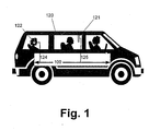
- Vehicles represent a particular environment in which navigational data, wireless communications and audiovisual programming, for entertainment or information, are frequently desired.
- the present invention contemplates a vehicle (120) that includes an on-board digital data network (100).
- vehicle encompasses all forms of motorized transportation, including, but not limited to, cars, vans, trucks, buses, sport-utility vehicles, airplanes, aircraft, boats, ships and the like.
- the on-board digital data network (100) is a fiber optic network.
- fiber optic networks are robust and capable of carrying large amounts of digital data.
- network refers to a data-bearing link between electronic devices that are connected to the data-bearing link at least two different points.
- data e.g., audiovisual programming data
- the network (100) can be communicated by the network (100) to various parts of the vehicle (120) for use by vehicle passengers.
- one passenger may be watching a television, video monitor or display device (121) that is connected (125) to the data network (100) and receives an appropriate video or audiovisual signal there from.
- another passenger may be listening to an audio program through a set of headphones (122) that are connected (124) to the network (100) and receive an audio signal there from.
- the network (100) can carry digital data in any format. Consequently, the network (100) maybe carrying, for example, a DVD audiovisual data stream; and/or an MPEG-1, MPEG-2 or MPEG-4 audiovisual data stream; and/or a Motion JPEG or Video CD (VCD) audiovisual data stream, and/or a CD audio data stream, and/or an MP3 audio data stream, etc.
- the network can also carry multiple data streams simultaneously.
- the network will have to carry data in a format useable by the various output devices, or those output devices will have to be connected to the network with an interface that translates the incoming audiovisual data stream into a form useable by that output device.
- audiovisual output device or “output device” refers to any device that renders an audiovisual signal or data stream perceptible, visually or aurally, to a human user. Consequently, output devices include, but are not limited to, speakers, headphones, earpieces, display devices, LCDs, video monitors, televisions, cathode ray tubes, etc.
- Fig. 2 is a block diagram of an antenna farm for a GPS receiver and wireless network transceivers that are interfaced with the in-vehicle data network (100) according to the principles of the present invention.
- the present invention preferably includes an antenna farm (125).
- the antenna farm (125) preferably includes a GPS receiver (113) with an antenna (111).
- this GPS receiver (113) receives transmissions from a number of orbiting satellites via the antenna (111). With the data from these transmissions, the receiver (113) can determine its physical location in the world, usually in terms of longitude and latitude, and, perhaps, altitude.
- the GPS receiver (113) may receive data from 24 satellites circling the Earth. This data is converted to National Marine Electronics Association (NMEA) standard data packets. These data packets are transmitted to an appropriately programmed micro-controller (106) that reads the data and can determine from the data the vehicles' latitude, longitude, heading, speed, etc.
- NMEA National Marine Electronics Association
- this supplementary navigational equipment may be an inertial sensor stage (112).
- the inertial sensor stage (112) may include an altimeter, odometer reading, speedometer reading, gyro, accelerometer, wheel speed/direction sensors, digital compass, etc.
- the digital compass of the inertial sensor obtains vehicle-heading information from a circuit that detects the Earth's magnetic field.
- This heading data is also provided to the GPS receiver or the micro-controller (106) and is used to check or replace the heading data provided by the GPS receiver (113) if the vehicle is moving too slowly for the data from the GPS receiver (113) to provide an accurate vehicle heading indication.
- Fig. 2a illustrates the use of the combined resources of the GPS receiver (113) and the inertial sensor stage (112).
- Fig. 2a may also be considered as a diagram for software or programming run by the micro-controller (106) when utilizing data from the GPS receiver (113) and the inertial sensor stage (112).
- the micro-controller receives data from the GPS receiver (150). With this data, the micro-controller assesses the speed of the vehicle (151). The micro-controller may also receive data from the vehicle speedometer to determine vehicle speed. Below a predetermined speed, the GPS data will be considered as providing an unreliable indication of the vehicle's heading (152).
- the GPS data will be used to determine the vehicle's latitude, longitude, heading, etc. (153). Alternatively, if the speed is low enough to render GPS heading data unreliable, data from the inertial sensor will be used to determine heading (154). The GPS data will be used to determine the vehicle's latitude and longitude (155).
- data from the GPS receiver can also be used to improve the performance of the inertial sensor.
- the GPS receiver can improve the accuracy of the inertial sensor by indicating geographically where the inertial sensor is.
- the inertial sensor in a vehicle is initially calibrated based on where the vehicle is sold. This is done by manually entering a declination zone number for the declination zone in which the vehicle is sold. A correction factor for the inertial sensor is automatically associated with the indicated declination zone.
- the inertial sensor will no longer be properly calibrated and will, therefore, be inaccurate. This inaccuracy can amount to as much as 30 degrees if, for example, the vehicle is driven across the continental United States. Because this need to calibrate the inertial sensor is not well known and is usually performed by sales staff before a vehicle is purchased, the vehicle may be moved into another declination zone, perhaps permanently, without the inertial sensor being properly re-calibrated.
- the GPS receiver (113) can always determine its latitude and longitude. This will also indicate in which declination zone the GPS receiver (113), and the inertial sensor (112), are located.
- Fig. 2b illustrates this use of the GPS data to calibrate the inertial sensor stage (112).
- Fig. 2b may also be considered as a diagram for software or programming run by the micro-controller (106) when utilizing data from the GPS receiver (113) and the inertial sensor stage (112).
- the micro-controller receives data from the GPS receiver (160).
- the GPS data specifies or is used to determine the latitude and longitude of the vehicle (161). It can then be determined if the vehicle has moved from the original declination zone into another (162). If no such movement has occurred, the current calibration or correction factor for the inertial sensor is maintained (163).
- a new correction factor for the inertial sensor is identified (164). This may be done through a look-up table available to the micro-controller or other means. This new correction factor is then applied to the data output by the inertial sensor (165) to obtain an accurate vehicle heading.
- the micro-controller (106) can make that information available to other devices over the digital network (100).
- the navigational data (127) can be transmitted from the micro-controller (106) to the data format stage (107) where the data is formatted for transmission over the network (100) and for use by other networked devices.
- the micro-controller (106) then sends a control signal (105) to the network interface stage (101).
- the network interface stage (101) also receives the formatted navigational data (103) from the data format stage (107).
- the network interface stage (101) then transmits that formatted navigational data over the in-vehicle data network (100).
- the network (100) is a fiber optic network.
- the network interface stage (101) includes an optical transceiver.
- the interface (101) then transmits and receives optical data signals, including sending the navigational data over the network (100) for use by other networked devices.
- the use of the navigational data by other networked devices will be explained below in more detail in connection with Fig. 4.
- the micro-controller (106), the data format stage (107) and the network interface stage (101) are preferably all provided on a common processor board (126).
- This board (126) is considered part of, and supports, the antenna farm (125).
- the antenna farm (125) also preferably includes the ability to communicate with a wireless personal area network (WPAN), a wireless local area network (WLAN), and a wireless wide area network (WWAN).
- WPAN wireless personal area network
- WLAN wireless local area network
- WWAN wireless wide area network
- the antenna farm (125) preferably includes an antenna (130) connected to a WPAN stage (132), an antenna (109) connected to a WLAN stage (115) and another antenna (110) connected to a WWAN stage (114).
- the multiple device stages may be able to use some common components if possible.
- WWANs include the well-known infrastructures by which wireless phones transmit voice and data.
- WWANs include, but are not limited to, GSM, GPRS, SMS, TDMA, CDMA, WCDMA, CDMA2000, CDPD, AMPS, EDGE, SMS, PCS and other networks.
- a WWAN can be analog, digital, narrow band, wide band, voice, packet data, message data, etc.
- WLANs usually cover a smaller service area than a WWAN, but can also carry both data and voice communications.
- Examples of WLANs include, but are not limited to, IEEE 802.11, HomeRF, HiperLAN and other networks.
- WPANs usually cover a smaller service area than a WLAN, but can also carry voice and data communications. Examples of WPANs include, but are not limited to, 802.15, Bluetooth, and other networks. Consequently, the WLAN stage (115) may output both a data stream (116) and a voice stream (117). Similarly, the WWAN stage (114) may also output a data stream (119) and a voice stream (118). Also, the WPAN stage (132) may output a data stream (134) and a voice stream (136).
- the voice streams (117, 118) from the WWAN stage (114), WPAN stage (132) and the WLAN stage (115) are typically received as analog signals are therefore sent to an analog-to-digital converter (108).
- This converter (108) may also be referred to as an audio CODEC stage.
- the converter or CODEC (108) renders these signals (118, 117) as a digital voice stream (102).
- the digital voice data stream (102) is sent to the network interface stage (101) for transmission on the in-vehicle network (100).
- This link is also two-way.
- digital voice data may be transmitted over the network (100) from a microphone interfaced with the network (100).
- This incoming voice data stream is sent (102) to the converter (108) where it is converted into an analog audio signal (118, 117).
- the analog audio signal (118, 117) can then be sent to either the WWAN stage (114), WLAN stage (115), or the WPAN stage (132) for transmission to the respective WWAN, WLAN or WPAN operating the service area where the vehicle is located.
- the WWAN, WLAN and WPAN can also be used for data communications.
- a data signal (119, 116) is received by the WWAN stage (114), WLAN stage (115), or WPAN stage (132), that data signal (119, 116, 134) is sent to the data format stage (107) where it is formatted for transmission over the network (100).
- the formatted data (103) is output by the data format stage (107) to the network interface stage (101) for transmission over the network (100).
- Digital data may be transmitted to the antenna farm (125) over the network (100).
- the data is received by the network interface stage (101) and then provided to the data format stage (107). From the data format stage (107) the data can be sent (119, 116) to the WWAN stage (114), the WLAN stage (115), or the WPAN stage (132) for wireless transmission to either or both of those networks.
- Fig. 3 is a more detailed diagram of the GPS receiver and supporting systems illustrated in Fig. 2.
- the antenna (111) is connected through an antenna connector (111a) to the GPS receiver stage (113).
- the GPS receiver stage (113) receives the satellite transmissions that enable the GPS receiver stage (113) to generate navigational data.
- the GPS receiver stage (113) is connected to the antenna farm system through a connector (113a), preferably a 20-pin connector as shown in Fig. 3.
- the GPS Module powers up in NMEA protocol, 4800,N,8,1.
- the inertial sensor of the antenna farm may, in the specific example of Fig. 3, be a digital compass (112a).
- a connector (112b), preferably a 4-pin connector (112b) as shown in Fig. 3 connects the digital compass (112a) to the antenna farm system.
- the antenna farm system is controlled by the micro-controller (106).
- the antenna farm system is interfaced with the in-vehicle data network (100) through the network interface stage (101).
- the network interface stage will include a fiber optic transceiver (204).
- Hardware jumpers on the board in the form of zero ohm resistors may be used to make the connection from the GPS system to the fiber optic transceiver (204).
- a power circuit (203) is also provided to power the various components of the GPS receiver stage and supporting electronics as shown in Fig. 3.
- the power supply is preferably 5.0V +/-2% (4.9V to 5.1V).
- Battery backup (VBAT) of 1.8V to 3.8V 10uA may also be provided.
- a transceiver (200) supporting two serial ports (201, 202) may be integrated into the GPS system illustrated in Fig. 3. Standard headers may be used for all power and serial ports.
- Fig. 4 is a block diagram illustrating the distribution of navigational data generated by the GPS and inertial sensor systems to networked devices distributed throughout a vehicle. Fig. 4 also illustrates how wireless communications are provided via the antenna farm to and from various networked devices distributed throughout the vehicle.
- the antenna farm (125) provides, among other things, navigational data from the GPS and inertial sensor systems.
- This navigational data is transmitted over the in-vehicle data network (100) for use by other networked devices.
- this navigational data may be taken from the network by a network interface (101a) for display on a display device (300).
- This display device (300) may display basic navigational data or may combine the navigational data with an interactive map of the area in which the vehicle is located.
- the navigational data may be taken from the network (100) through the same or another network interface (101b) for display by the vehicle's instrument panel (301).
- vehicle instrument panels (301) include a compass reading and other navigational data that can be displayed based on the navigational data provided over the network (100) from the antenna farm (125). Data can also be displayed in mirrors, visors, etc.
- the antenna farm (125) can also provide two-way wireless communications with an area WWAN, WLAN or WPAN,
- a data stream received from a WWAN, WLAN or WPAN can be received by the antenna farm (125) and distributed over the network (100).
- the display device (300) may then obtain this data from the network (100) through an interface (101a) and display the data for a user.
- this data stream may be a connection to the Internet and the user may view a web page or an e-mail with the display device (300).
- a user input device (303) is preferably associated with the display device (300).
- the user input device (303) may be a touch-screen on the display device (300), a keyboard or keypad, or any other device that allows a user to input commands or data.
- the user can input data, such as a request for another web page at another URL or a reply to an e-mail message.
- This data is then transmitted to the network (100) through the interface (101a).
- the outgoing data is then received by the antenna farm (125) through the interface (101) and transmitted to the WWAN or WLAN with which the user is communicating.
- a speaker (302) may be connected to the network (100) through a network interface (101c).
- a digital audio signal can be taken from the network (100) by the interface (101c) and rendered audible by the speaker (302).
- This digital audio signal could be a voice transmission, e.g., a wireless telephone call, coming in through the WLAN or WWAN stages of the antenna farm (125).
- this audio signal could be audio or audiovisual programming produced by, for example, a CD audio player or a radio tuner connected to the network (100).
- the speaker (302) can serve many purposes within the network.
- a microphone (304) may be connected to the network (100) through a network interface (101d). This microphone (304) can transduce the speech of a user to generate a voice data stream that is transmitted over the network (100) to the antenna farm (125) for transmission via the WWAN or WLAN stages.
- a user can conduct a wireless telephone call through the antenna farm (125) of the present invention.
- this maybe a hands-free system for conducting such a phone call.
Abstract
Description
- The present invention relates to the field of navigation in a motorized vehicle. The present invention also relates to the field of wireless communication of voice and data streams. The present invention also relates to the field of distributing data over a digital data network. More particularly, the present invention relates to a means and method of interfacing navigational equipment, such as a Global Positioning System (GPS), and wireless voice and data networks with a wired, digital data network installed in a vehicle so that data from the navigational equipment and wireless networks can be distributed and used by devices on the in-vehicle network.
- Global Positioning Systems (GPS) are self-contained, portable devices that use transmissions from a number of orbiting satellites to determine their own location. A GPS unit can define its location in terms of latitude and longitude anywhere in the world.
- For obvious reasons, GPS units are commonly used in motorized vehicles: cars, trucks, buses, boats, ships, aircraft, etc. With the information from an on-board GPS unit, and a review of how that information changes over time, a vehicle's direction or heading, velocity and other parameters can be determined. Additionally, other navigational equipment can be used to supplement the data generated by a GPS unit.
- GPS units are also often integrated with an electronic mapping system. The mapping system may include a display device on which a map of the user's locality is displayed. With the GPS data, the position of the user or the user's vehicle can be illustrated on the displayed map to assist a user in finding his or her way to a destination that is also mapped. The mapping system may also be able to generate directions or prompts based on a designated destination and the user's current location as identified by the GPS data.
- While GPS units and related equipment help a user navigate while in unfamiliar territory, the user can also stay in communication while roaming using a wireless telephone. Wireless telephones operate by transmitting radio frequency (RF) signals between the user's handset unit and a network of base stations distributed throughout a service area. These wireless networks, sometimes referred to as Wireless Wide-Area Networks (WWANs), can be used to transmit data as well as voice to and from the user's location.
- In addition to conventional WWAN infrastructure for supporting wireless telephones and other wireless data devices, some localities are developing wireless data networks on a more limited scale. These networks, Wireless Local-Area Networks (WLANs), may exist, for example, in a particular building, among a complex of buildings, in a particular neighborhood or business district, etc. WLANs can also be used for carrying data, including voice data, to and from a user's registered wireless device. Additionally, a Wireless Personal Area Network (WPAN) will allow wireless devices to communicate inside the vehicle. These networks can connect cellphones, headphones, personal digital assistants and other information devices over a limited range.
- Thus, GPS and other navigational equipment help a user to constantly identify his or her position and navigate to a desired destination, At the same time, wireless networks and the devices that communicate with those networks, allow the user to remain in voice and data communication while traveling. Consequently, a natural environment for the use of both GPS and wireless communications is in a user's vehicle.
- This being the case, there is a need in the art for an improved means and method of integrating GPS and wireless communication systems with the systems of a user's vehicle so as to make the GPS and wireless communication systems more readily and safely accessible to the vehicle operator during travel.
- The present invention meets the above-described needs and others. Specifically, the present invention provides an improved means and method of integrating GPS and wireless communication systems with the systems of a user's vehicle so as to make the GPS and wireless communication systems more readily and safely accessible to the vehicle operator during travel.
- Additional advantages and novel features of the invention will be set forth in the description which follows or may be learned by those skilled in the art through reading these materials or practicing the invention. The advantages of the invention may be achieved through the means recited in the attached claims.
- The present invention may be embodied and described as a navigational system for a vehicle having: a GPS receiver; a digital data network installed in the vehicle; and a network interface connecting the GPS receiver and the digital data network. The GPS receiver outputs navigational data on the digital data network.
- In another embodiment, the present invention may provide a wireless communication system for a vehicle having: a wireless network stage with an antenna for communicating with a wireless network that has a service area in which the vehicle is located; a digital data network installed in the vehicle; and a digital network interface connecting the wireless network stage to the digital data network so that data received via the wireless network stage can be transmitted over the digital data network and data from the digital data network can be transmitted to the wireless network via the wireless network stage.
- The present invention also encompasses an embodiment that combines these two systems. Thus, the present invention may be embodied as a navigational and communications system for a vehicle having: a GPS receiver; a wireless network stage with an antenna for communicating with a wireless network that has a service area in which the vehicle is located; a digital data network installed in the vehicle; and a digital network interface connecting the wireless network stage and the GPS receiver to the digital data network. Data received via the wireless network stage can be transmitted over the digital data network and data from the digital data network can be transmitted to the wireless network via the wireless network stage. The GPS receiver also outputs navigational data on the digital data network.
- The present invention also encompasses the methods of making and operating the systems that embody the present invention. For example, the present invention encompasses a method of providing navigational data in a vehicle by connecting a GPS receiver through a network interface to a digital data network installed in the vehicle such that the GPS receiver will output navigational data on the digital data network.
- The present invention also encompasses a method of providing wireless communications in a vehicle by providing a wireless network stage for communicating with a wireless network that has a service area in which the vehicle is located; and providing a connection between the wireless network stage and a digital data network installed in the vehicle. In addition, the present invention encompasses a method of providing wireless communications between devices inside the vehicle, and providing a connection between the wireless network stage and a digital network installed in the vehicle.
- The present invention also encompasses a method of providing navigational and communication systems for a vehicle by connecting a GPS receiver through a network interface to a digital data network installed in the vehicle such that the GPS receiver will output navigational data on the digital data network; providing a wireless network stage for communicating with a wireless network that has a service area in which the vehicle is located; and providing a connection between the wireless network stage and the digital data network installed in the vehicle.
- The accompanying drawings illustrate preferred embodiments of the present invention and are a part of the specification. Together with the following description, the drawings demonstrate and explain the principles of the present invention.
- Fig. I is an illustration of an exemplary vehicle with a digital data network installed on-board as contemplated by the principles of the present invention.
- Fig. 2 is a block diagram of an antenna farm for a GPS receiver and wireless network transceivers that may be connected to an in-vehicle data network according to the principles of the present invention.
- Fig. 2a is a flowchart outlining the operation for processing navigational data from the GPS receiver and inertial sensor of Fig. 2. Fig. 2a may also be considered as a software diagram for some of the programming run by the micro-controller of Fig. 2.
- Fig. 2b is a flowchart outlining the operation for updating the correction factor applied to the data from the inertial sensor of Fig. 2 based on the location of the vehicle. Fig. 2b may also be considered as a software diagram for some of the programming run by the micro-controller of Fig. 2.
- Fig. 3 is a more detailed diagram of the GPS receiver and supporting systems illustrated in Fig. 2.
- Fig. 4 is a block diagram illustrating the use of navigational data and wireless communications generated by the antenna farm of Fig. 2 by networked devices distributed throughout a vehicle.
- Throughout the drawings, identical elements are designated by identical reference numbers.
- The present invention provides an improved means and method of integrating GPS and wireless communication systems with the systems of a user's vehicle so as to make the GPS and wireless communication systems more readily and safely accessible to the vehicle operator during travel. GPS and data from other navigational equipment is transmitted over a digital data network, preferably a fiber optic network, that is provided in a vehicle for distributing data among the various electronic devices on-board. Voice and data streams sent to, and received from, wireless networks operating in the area, e.g., a WWAN, WLAN or WPAN, are also distributed over the fiber optic network for use by various on-board devices.
- Using the drawings, the preferred embodiments of the present invention will now be explained.
- Vehicles represent a particular environment in which navigational data, wireless communications and audiovisual programming, for entertainment or information, are frequently desired. To meet the need for audiovisual programming, in particular, as shown in Fig. 1, the present invention contemplates a vehicle (120) that includes an on-board digital data network (100). As will be understood, the term "vehicle" as used herein, and in the appended claims, encompasses all forms of motorized transportation, including, but not limited to, cars, vans, trucks, buses, sport-utility vehicles, airplanes, aircraft, boats, ships and the like.
- Preferably, the on-board digital data network (100) is a fiber optic network. Generally, fiber optic networks are robust and capable of carrying large amounts of digital data. As used herein and in the appended claims, the term "network" refers to a data-bearing link between electronic devices that are connected to the data-bearing link at least two different points.
- With the provision of the data network (100) in the vehicle, data, e.g., audiovisual programming data, can be communicated by the network (100) to various parts of the vehicle (120) for use by vehicle passengers. For example, one passenger may be watching a television, video monitor or display device (121) that is connected (125) to the data network (100) and receives an appropriate video or audiovisual signal there from. Additionally, another passenger may be listening to an audio program through a set of headphones (122) that are connected (124) to the network (100) and receive an audio signal there from.
- The network (100) can carry digital data in any format. Consequently, the network (100) maybe carrying, for example, a DVD audiovisual data stream; and/or an MPEG-1, MPEG-2 or MPEG-4 audiovisual data stream; and/or a Motion JPEG or Video CD (VCD) audiovisual data stream, and/or a CD audio data stream, and/or an MP3 audio data stream, etc. By packetizing data, the network can also carry multiple data streams simultaneously. Obviously, the network will have to carry data in a format useable by the various output devices, or those output devices will have to be connected to the network with an interface that translates the incoming audiovisual data stream into a form useable by that output device.
- As used herein and in the appended claims, the term "audiovisual output device" or "output device" refers to any device that renders an audiovisual signal or data stream perceptible, visually or aurally, to a human user. Consequently, output devices include, but are not limited to, speakers, headphones, earpieces, display devices, LCDs, video monitors, televisions, cathode ray tubes, etc.
- In addition to supporting the distribution and playback of audio and audiovisual programming through audiovisual output devices in the vehicle, the data network (100) can also be used, under the principles of the present invention, to make GPS, other navigational data, and wireless communications available to a number of users throughout the vehicle (120). Fig. 2 is a block diagram of an antenna farm for a GPS receiver and wireless network transceivers that are interfaced with the in-vehicle data network (100) according to the principles of the present invention.
- As shown in Fig. 2, the present invention preferably includes an antenna farm (125). The antenna farm (125) preferably includes a GPS receiver (113) with an antenna (111). As noted above, this GPS receiver (113) receives transmissions from a number of orbiting satellites via the antenna (111). With the data from these transmissions, the receiver (113) can determine its physical location in the world, usually in terms of longitude and latitude, and, perhaps, altitude.
- More specifically, the GPS receiver (113) may receive data from 24 satellites circling the Earth. This data is converted to National Marine Electronics Association (NMEA) standard data packets. These data packets are transmitted to an appropriately programmed micro-controller (106) that reads the data and can determine from the data the vehicles' latitude, longitude, heading, speed, etc.
- If the vehicle's speed is low, however, the correspondingly slow change in GPS data can make it difficult to accurately determine the vehicle's heading. Consequently, other navigational equipment may be used to supplement the GPS receiver (113). In the exemplary embodiment of Fig. 2, this supplementary navigational equipment may be an inertial sensor stage (112). The inertial sensor stage (112) may include an altimeter, odometer reading, speedometer reading, gyro, accelerometer, wheel speed/direction sensors, digital compass, etc. In particular, the digital compass of the inertial sensor obtains vehicle-heading information from a circuit that detects the Earth's magnetic field. This heading data is also provided to the GPS receiver or the micro-controller (106) and is used to check or replace the heading data provided by the GPS receiver (113) if the vehicle is moving too slowly for the data from the GPS receiver (113) to provide an accurate vehicle heading indication.
- Fig. 2a illustrates the use of the combined resources of the GPS receiver (113) and the inertial sensor stage (112). Fig. 2a may also be considered as a diagram for software or programming run by the micro-controller (106) when utilizing data from the GPS receiver (113) and the inertial sensor stage (112).
- As shown in Fig. 2a, the micro-controller receives data from the GPS receiver (150). With this data, the micro-controller assesses the speed of the vehicle (151). The micro-controller may also receive data from the vehicle speedometer to determine vehicle speed. Below a predetermined speed, the GPS data will be considered as providing an unreliable indication of the vehicle's heading (152).
- If the vehicle's speed is above the threshold speed, the GPS data will be used to determine the vehicle's latitude, longitude, heading, etc. (153). Alternatively, if the speed is low enough to render GPS heading data unreliable, data from the inertial sensor will be used to determine heading (154). The GPS data will be used to determine the vehicle's latitude and longitude (155).
- In addition to this arrangement in which data from the inertial sensor is used to correct or supplement the data from the GPS receiver, data from the GPS receiver can also be used to improve the performance of the inertial sensor. The GPS receiver can improve the accuracy of the inertial sensor by indicating geographically where the inertial sensor is.
- Throughout the world, there are local variations in the Earth's magnetic field. Additionally, the effective angular difference between the geographic North Pole and the magnetic north pole will vary depending on the vehicle's location. Thus, a correction factor must be used when interpreting the output of the inertial sensor to get an accurate indication of the vehicle's heading. Typically, the inertial sensor in a vehicle is initially calibrated based on where the vehicle is sold. This is done by manually entering a declination zone number for the declination zone in which the vehicle is sold. A correction factor for the inertial sensor is automatically associated with the indicated declination zone.
- If the vehicle is driven into another declination zone, the inertial sensor will no longer be properly calibrated and will, therefore, be inaccurate. This inaccuracy can amount to as much as 30 degrees if, for example, the vehicle is driven across the continental United States. Because this need to calibrate the inertial sensor is not well known and is usually performed by sales staff before a vehicle is purchased, the vehicle may be moved into another declination zone, perhaps permanently, without the inertial sensor being properly re-calibrated.
- This problem is addressed in the present invention using the GPS receiver (113). As noted above, the GPS receiver (113) can always determine its latitude and longitude. This will also indicate in which declination zone the GPS receiver (113), and the inertial sensor (112), are located.
- Consequently, re-calibration of the inertial sensor (112) as to declination zone can be done automatically using the data from the GPS receiver (113). In this way, the inertial sensor (112) will remain calibrated for maximum accuracy even if the vehicle is taken from one declination zone to another.
- Fig. 2b illustrates this use of the GPS data to calibrate the inertial sensor stage (112). Fig. 2b may also be considered as a diagram for software or programming run by the micro-controller (106) when utilizing data from the GPS receiver (113) and the inertial sensor stage (112).
- As shown in Fig. 2b, the micro-controller receives data from the GPS receiver (160). The GPS data specifies or is used to determine the latitude and longitude of the vehicle (161). It can then be determined if the vehicle has moved from the original declination zone into another (162). If no such movement has occurred, the current calibration or correction factor for the inertial sensor is maintained (163).
- However, if the latitude and longitude readings indicate that the vehicle has moved to another declination zone, a new correction factor for the inertial sensor is identified (164). This may be done through a look-up table available to the micro-controller or other means. This new correction factor is then applied to the data output by the inertial sensor (165) to obtain an accurate vehicle heading.
- Returning to Fig. 2, after the micro-controller (106) receives the navigational information from the inertial sensor stage (112) and the GPS receiver stage (113), the micro-controller (106) can make that information available to other devices over the digital network (100). The navigational data (127) can be transmitted from the micro-controller (106) to the data format stage (107) where the data is formatted for transmission over the network (100) and for use by other networked devices.
- The micro-controller (106) then sends a control signal (105) to the network interface stage (101). The network interface stage (101) also receives the formatted navigational data (103) from the data format stage (107). The network interface stage (101) then transmits that formatted navigational data over the in-vehicle data network (100).
- Preferably, the network (100) is a fiber optic network. In which case, the network interface stage (101) includes an optical transceiver. The interface (101) then transmits and receives optical data signals, including sending the navigational data over the network (100) for use by other networked devices. The use of the navigational data by other networked devices will be explained below in more detail in connection with Fig. 4.
- As shown in Fig. 2, the micro-controller (106), the data format stage (107) and the network interface stage (101) are preferably all provided on a common processor board (126). This board (126) is considered part of, and supports, the antenna farm (125).
- In addition to providing the navigational data from the inertial sensor (112) and the GPS receiver stage (113), the antenna farm (125) also preferably includes the ability to communicate with a wireless personal area network (WPAN), a wireless local area network (WLAN), and a wireless wide area network (WWAN). To this end, the antenna farm (125) preferably includes an antenna (130) connected to a WPAN stage (132), an antenna (109) connected to a WLAN stage (115) and another antenna (110) connected to a WWAN stage (114). To reduce cost, the multiple device stages may be able to use some common components if possible.
- As noted above, WWANs include the well-known infrastructures by which wireless phones transmit voice and data. Examples of WWANs include, but are not limited to, GSM, GPRS, SMS, TDMA, CDMA, WCDMA, CDMA2000, CDPD, AMPS, EDGE, SMS, PCS and other networks. A WWAN can be analog, digital, narrow band, wide band, voice, packet data, message data, etc.
- WLANs usually cover a smaller service area than a WWAN, but can also carry both data and voice communications. Examples of WLANs include, but are not limited to, IEEE 802.11, HomeRF, HiperLAN and other networks. WPANs usually cover a smaller service area than a WLAN, but can also carry voice and data communications. Examples of WPANs include, but are not limited to, 802.15, Bluetooth, and other networks. Consequently, the WLAN stage (115) may output both a data stream (116) and a voice stream (117). Similarly, the WWAN stage (114) may also output a data stream (119) and a voice stream (118). Also, the WPAN stage (132) may output a data stream (134) and a voice stream (136).
- The voice streams (117, 118) from the WWAN stage (114), WPAN stage (132) and the WLAN stage (115) are typically received as analog signals are therefore sent to an analog-to-digital converter (108). This converter (108) may also be referred to as an audio CODEC stage. Under control (104) of the micro-controller (106), the converter or CODEC (108) renders these signals (118, 117) as a digital voice stream (102). The digital voice data stream (102) is sent to the network interface stage (101) for transmission on the in-vehicle network (100).
- This link is also two-way. For example, digital voice data may be transmitted over the network (100) from a microphone interfaced with the network (100). This incoming voice data stream is sent (102) to the converter (108) where it is converted into an analog audio signal (118, 117). The analog audio signal (118, 117) can then be sent to either the WWAN stage (114), WLAN stage (115), or the WPAN stage (132) for transmission to the respective WWAN, WLAN or WPAN operating the service area where the vehicle is located.
- In addition to voice communications, the WWAN, WLAN and WPAN can also be used for data communications. When a data signal (119, 116) is received by the WWAN stage (114), WLAN stage (115), or WPAN stage (132), that data signal (119, 116, 134) is sent to the data format stage (107) where it is formatted for transmission over the network (100). The formatted data (103) is output by the data format stage (107) to the network interface stage (101) for transmission over the network (100).
- Again, this is a two-way link. Digital data may be transmitted to the antenna farm (125) over the network (100). The data is received by the network interface stage (101) and then provided to the data format stage (107). From the data format stage (107) the data can be sent (119, 116) to the WWAN stage (114), the WLAN stage (115), or the WPAN stage (132) for wireless transmission to either or both of those networks.
- Fig. 3 is a more detailed diagram of the GPS receiver and supporting systems illustrated in Fig. 2. As shown in Fig. 3, the antenna (111) is connected through an antenna connector (111a) to the GPS receiver stage (113). Through the antenna (111), the GPS receiver stage (113) receives the satellite transmissions that enable the GPS receiver stage (113) to generate navigational data. The GPS receiver stage (113) is connected to the antenna farm system through a connector (113a), preferably a 20-pin connector as shown in Fig. 3. Preferably, the GPS Module powers up in NMEA protocol, 4800,N,8,1.
- The inertial sensor of the antenna farm may, in the specific example of Fig. 3, be a digital compass (112a). A connector (112b), preferably a 4-pin connector (112b) as shown in Fig. 3 connects the digital compass (112a) to the antenna farm system.
- As before, the antenna farm system is controlled by the micro-controller (106). The antenna farm system is interfaced with the in-vehicle data network (100) through the network interface stage (101). In the preferred embodiment in which the network (100) is a fiber optic network, the network interface stage will include a fiber optic transceiver (204).
- Hardware jumpers on the board in the form of zero ohm resistors may be used to make the connection from the GPS system to the fiber optic transceiver (204).
- A power circuit (203) is also provided to power the various components of the GPS receiver stage and supporting electronics as shown in Fig. 3. The power supply is preferably 5.0V +/-2% (4.9V to 5.1V). Battery backup (VBAT) of 1.8V to 3.8V 10uA may also be provided.
- It may also be desirable to interface other devices, such as an electronic mapping system, directly with the GPS receiver stage of Fig. 3 without connecting to the network (100). For this purpose, a transceiver (200) supporting two serial ports (201, 202) may be integrated into the GPS system illustrated in Fig. 3. Standard headers may be used for all power and serial ports.
- Fig. 4 is a block diagram illustrating the distribution of navigational data generated by the GPS and inertial sensor systems to networked devices distributed throughout a vehicle. Fig. 4 also illustrates how wireless communications are provided via the antenna farm to and from various networked devices distributed throughout the vehicle.
- As shown in Fig. 4 and as described above, the antenna farm (125) provides, among other things, navigational data from the GPS and inertial sensor systems. This navigational data is transmitted over the in-vehicle data network (100) for use by other networked devices. For example, this navigational data may be taken from the network by a network interface (101a) for display on a display device (300). This display device (300) may display basic navigational data or may combine the navigational data with an interactive map of the area in which the vehicle is located.
- Additionally or alternatively, the navigational data may be taken from the network (100) through the same or another network interface (101b) for display by the vehicle's instrument panel (301). For example, some vehicle instrument panels (301) include a compass reading and other navigational data that can be displayed based on the navigational data provided over the network (100) from the antenna farm (125). Data can also be displayed in mirrors, visors, etc.
- As described above, the antenna farm (125) can also provide two-way wireless communications with an area WWAN, WLAN or WPAN, For example, a data stream received from a WWAN, WLAN or WPAN can be received by the antenna farm (125) and distributed over the network (100). The display device (300) may then obtain this data from the network (100) through an interface (101a) and display the data for a user. For example, this data stream may be a connection to the Internet and the user may view a web page or an e-mail with the display device (300).
- A user input device (303) is preferably associated with the display device (300). The user input device (303) may be a touch-screen on the display device (300), a keyboard or keypad, or any other device that allows a user to input commands or data.
- With a user input device (303), the user can input data, such as a request for another web page at another URL or a reply to an e-mail message. This data is then transmitted to the network (100) through the interface (101a). The outgoing data is then received by the antenna farm (125) through the interface (101) and transmitted to the WWAN or WLAN with which the user is communicating.
- As noted above, the system of the present invention may also be used for voice communication. For example, a speaker (302) may be connected to the network (100) through a network interface (101c). A digital audio signal can be taken from the network (100) by the interface (101c) and rendered audible by the speaker (302). This digital audio signal could be a voice transmission, e.g., a wireless telephone call, coming in through the WLAN or WWAN stages of the antenna farm (125). Alternatively, this audio signal could be audio or audiovisual programming produced by, for example, a CD audio player or a radio tuner connected to the network (100). Thus, the speaker (302) can serve many purposes within the network.
- Additionally, a microphone (304) may be connected to the network (100) through a network interface (101d). This microphone (304) can transduce the speech of a user to generate a voice data stream that is transmitted over the network (100) to the antenna farm (125) for transmission via the WWAN or WLAN stages. Thus, with the speaker (302) and microphone (304), a user can conduct a wireless telephone call through the antenna farm (125) of the present invention. Preferably, this maybe a hands-free system for conducting such a phone call.
- The preceding description has been presented only to illustrate and describe the invention. It is not intended to be exhaustive or to limit the invention to any precise form disclosed. Many modifications and variations are possible in light of the above teaching.
- The preferred embodiment was chosen and described in order to best explain the principles of the invention and its practical application. The preceding description is intended to enable others skilled in the art to best utilize the invention in various embodiments and with various modifications as are suited to the particular use contemplated. It is intended that the scope of the invention be defined by the following claims.
Claims (43)
- A navigational system for a vehicle comprising:a Global Positioning System (GPS) receiver;a digital data network installed in said vehicle;a network interface connecting said GPS receiver and said digital data network, wherein said GPS receiver outputs navigational data on said digital data network;a first output device connected to said digital data network for receiving and outputting said navigational data from said GPS receiver; anda second output device connected to said digital data network for receiving and outputting an audio or audiovisual data stream transmitted over said digital data network.
- The system of claim 1, further comprising a display device connected to said digital data network for receiving and displaying said navigational data.
- The system of claim 1 or 2, further comprising an instrument panel of said vehicle, said instrument panel being connected to said digital data network such that said instrument panel receives and displays said navigational data from said GPS receiver.
- The system of any one of claims 1 to 3, wherein said audio data stream comprises musical programming.
- The system of any one of the preceding claims, wherein said audio visual data stream comprises audiovisual programming with both an audio component and a video component.
- A wireless communication system for a vehicle comprising:a wireless network stage with an antenna for communicating with a wireless network that has a service area in which said vehicle is located;a digital data network installed in said vehicle;a digital network interface connecting said wireless network stage to said digital data network for transferring data between said wireless network stage and said digital data network so that data received via said wireless network stage is transmitted over said digital data network and data from said digital data network is transmitted to said wireless network via said wireless network stage; andan output device interfaced with said digital data network for outputting said data to a human user.
- The system of claim 6, further comprising a display device connected to said digital data network for receiving and displaying data received through said wireless network stage and transmitted over said digital data network.
- A navigational and communications system for a vehicle comprising:wherein data received via said wireless network stage is transmitted over said digital data network and data from said digital data network is transmitted to said wireless network via said wireless network stage; anda Global Positioning System (GPS) receiver;a wireless network stage with an antenna for communicating with a wireless network that has a service area in which said vehicle is located;a digital data network installed in said vehicle; anda digital network interface connecting said wireless network stage and said GPS receiver to said digital data network;
wherein said GPS receiver outputs navigational data on said digital data network;
said system further comprising a display device connected to said digital data network for receiving and displaying either said navigational data from said GPS receiver or data received through said wireless network stage. - The system of any one of the preceding claims, wherein said digital data network is a fibre optic network and said network interface comprises a fibre optical transceiver.
- The system of any one of claims 1 to 5, 8 or 9, further comprising an inertial sensor that provides vehicle heading data to supplement said navigational data from said GPS receiver, said inertial sensor also being connected to said network interface.
- The system of any one of claims 6 to 10, further comprising a user input device connected to said digital data network for inputting data for transmission over said digital data network and by said wireless network stage.
- The system of any one of claims 6 to 11, further comprising an analog-to-digital converter for converting an analog voice signal received by said wireless network stage into a digital data stream for transmission over said digital data network by said digital network interface, and for converting a digital audio signal from said digital data network to an analog audio signal for transmission by said wireless network stage.
- The system of any one of claims 6 to 12, wherein said wireless network stage is a wireless personal area network stage for communicating with a wireless personal area network.
- The system of any one of claims 6 to 13, wherein said wireless network stage is a wireless local area network stage for communicating with a wireless local area network.
- The system of any one of claims 6 to 14, wherein said wireless network stage is a wireless wide area network stage for communicating with a wireless wide area network.
- The system of any one of claims 6 to 15, further comprising a wireless local area network stage for communicating with a wireless local area network.
- The system of any one of claims 6 to 16, further comprising a wireless personal area network stage for communicating with a wireless personal area network.
- The system of any one of claims 6 to 17, further comprising a speaker connected to said digital data network for rendering audible an audio data stream received via said wireless network stage and transmitted to said speaker over said digital data network.
- The system of any one of claims 6 to 18, further comprising a microphone connected to said digital data network for transducing an audio signal for transmission over said digital data network and by said wireless network stage.
- A method of providing navigational data in a vehicle comprising:connecting a GPS receiver through a network interface to a digital data network installed in said vehicle such that said GPS receiver will output navigational data on said digital data network; andsupplementing said navigational data from said GPS receiver with vehicle heading data from an inertial sensor also connected to said interface, wherein said heading data from said inertial sensor is substituted for heading data from said GPS receiver if a speed of said vehicle is below a predetermined threshold.
- A method of providing navigational data in a vehicle comprising:connecting a GPS receiver through a network interface to a digital data network installed in said vehicle such that said GPS receiver will output navigational data on said digital data network;supplementing said navigational data from said GPS receiver with vehicle heading data from an inertial sensor also connected to said network interface; andapplying a correction factor to said vehicle heading data from said inertial sensor based on a declination zone in which said vehicle is located as determined from said navigational data output by said GPS receiver.
- The method of claim 20 or 21, wherein said digital data network is a fibre optical network and said network interface comprises a fibre optic transceiver, said method further comprising converting said navigational data into an optical signal for transmission on said fibre optical network.
- The method of any one of claims 20 to 22, further comprising receiving and displaying said navigational data with a display device connected to said digital data network.
- A method of providing wireless communications in a vehicle comprising:providing a wireless network stage for communicating with a wireless network that has a service area in which said vehicle is located;providing a connection between said wireless network stage and a digital data network installed in said vehicle;transmitting data received via said wireless network stage over said digital data network;transmitting data from said digital data network via said wireless network stage to said wireless network; andoutputting said data for a human user with an output device connected to said digital data network such that said data is rendered in a form audible or visible to the human user.
- The method of claim 24, wherein said digital data network is a fibre optic network and said method further comprising converting said data into an optical data stream for transmission on said fibre optic network.
- The method of claim 24 or 25, further comprising converting an analog voice signal received by said wireless network stage into a digital data stream for transmission over said digital data network by said digital network interface, and converting a digital audio signal from said digital data network to an analog audio signal for transmission by said wireless network stage.
- The method of any one of claims 24 to 26, wherein said wireless network stage is a wireless local area network stage, and said method further comprises communicating with a wireless local area network.
- The method of any one of claims 24 to 27, wherein said wireless network stage is a wireless personal area network stage, and said method further comprises communicating with a wireless personal area network.
- The method of any one of claims 24 to 28, wherein said wireless network stage is a wireless wide area network stage, and said method further comprises communicating with a wireless wide area network.
- The method of claim 29, wherein said wireless network stage further comprises a wireless local area network stage, and said method further comprises communicating with a wireless local area network.
- The method of claim 30, wherein said wireless network stage further comprises a wireless personal area network stage, and said method further comprises communicating with a wireless personal area network.
- The method of any one of claims 24 to 31, further comprising rendering audible an audio data stream received via said wireless network stage and transmitted over said digital data network with a speaker connected to said digital data network.
- The method of any one of claims 24 to 32, further comprising transducing an audio signal for transmission over said digital data network and by said wireless network stage with a microphone connected to said digital data network.
- The method of any one of claims 24 to 33, further comprising receiving and displaying data received through said wireless network stage and transmitted over said digital data network with a display device connected to said digital data network.
- The method of claim 34, further comprising inputting data for transmission over said digital data network and by said wireless network stage with a user input device connected to said digital data network.
- A method of providing navigational and communication systems for a vehicle comprising:wherein said heading data from said inertial sensor is substituted for heading data from said GPS receiver if a speed of said vehicle is below a predetermined threshold.connecting a GPS receiver through a network interface to a digital data network installed in said vehicle such that said GPS receiver will output navigational data on said digital data network;providing a wireless network stage for communicating with a wireless network that has a service area in which said vehicle is located; andproviding a connection between said wireless network stage and said digital data network installed in said vehicle; andsupplementing said navigational data from said GPS receiver with vehicle heading data from an inertial sensor also connected to said network interface,
- A method of providing navigational and communication systems for a vehicle comprising:connecting a GPS receiver through a network interface to a digital data network installed in said vehicle such that said GPS receiver will output navigational data on said digital data network;providing a wireless network stage for communicating with a wireless network that has a service area in which said vehicle is located; andproviding a connection between said wireless network stage and said digital data network installed in said vehicle;supplementing said navigational data from said GPS receiver with vehicle heading data from an inertial sensor also connected to said network interface; andapplying a correction factor to said vehicle heading data from said inertial sensor based on a declination zone in which said vehicle is located as determined from said navigational data output by said GPS receiver.
- A method of supplementing navigational data from a GPS receiver with vehicle heading data from an inertial sensor, said method comprising substituting said vehicle heading data from said inertial sensor for heading data from said GPS receiver if a speed of said vehicle is below a predetermined threshold.
- A method of automatically calibrating an inertial sensor with output from a GPS receiver, said method comprising automatically applying a correction factor to vehicle heading data from said inertial sensor based on a declination zone in which said vehicle is located which is determined from said navigational data output by said GPS receiver.
- A navigational system for a vehicle comprising:a GPS receiver;a digital data network installed in said vehicle;a network interface connecting said GPS receiver and said digital data network, wherein said GPS receiver outputs navigational data on said digital data network;an inertial sensor that provides vehicle heading data to supplement said navigational data from said GPS receiver, said inertial sensor also being connected to said network interface; anda micro-controller for processing said navigational data and said vehicle heading data before said data is output on said digital data network, wherein said micro-controller will substitute said heading data from said inertial sensor for heading data from said GPS receiver if a speed of said vehicle is below a predetermined threshold.
- A navigational system for a vehicle comprising:a GPS receiver;a digital data network installed in said vehicle;a network interface connecting said GPS receiver and said digital data network, wherein said GPS receiver outputs navigational data on said digital data network;an inertial sensor that provides vehicle heading data to supplement said navigational data from said GPS receiver, said inertial sensor also being connected to said network interface; anda micro-controller for processing said navigational data and said vehicle heading data before said data is output on said digital data network, wherein said micro-controller will apply a correction factor to said vehicle heading data from said inertial sensor based on a declination zone in which said vehicle is located as determined from said navigational data output by said GPS receiver.
- A method of transmitting data over an in-vehicle digital data network, said method comprising:wherein said navigational data and said audio or audiovisual programming are transmitted over the same digital data network.transmitting Global Positioning System (GPS) data on a digital data network installed in a vehicle from a GPS receiver to an output device; andtransmitting audio or audiovisual programming over said digital data network to an output device connected to said in-vehicle network;
- A navigational system for a vehicle comprising:a Global Positioning System (GPS) receiver;a digital data network installed in said vehicle;a network interface connecting said GPS receiver and said digital data network, wherein said GPS receiver outputs navigational data on said digital data network;a first output device connected to said digital data network at a first point for receiving and outputting said navigational data to a human user; anda second output device connected to said digital data network at a second point, different from said first point, for receiving and outputting said navigational data to a human user.
Applications Claiming Priority (2)
| Application Number | Priority Date | Filing Date | Title |
|---|---|---|---|
| US11171 | 2001-12-06 | ||
| US10/011,171 US6684157B2 (en) | 2001-12-06 | 2001-12-06 | Method and system for interfacing a global positioning system, other navigational equipment and wireless networks with a digital data network |
Publications (2)
| Publication Number | Publication Date |
|---|---|
| EP1318381A2 true EP1318381A2 (en) | 2003-06-11 |
| EP1318381A3 EP1318381A3 (en) | 2006-07-12 |
Family
ID=21749165
Family Applications (1)
| Application Number | Title | Priority Date | Filing Date |
|---|---|---|---|
| EP02258445A Withdrawn EP1318381A3 (en) | 2001-12-06 | 2002-12-06 | Method and system for interfacing a global positioning system, other navigational equipment and wireless networks with a digital data network |
Country Status (3)
| Country | Link |
|---|---|
| US (1) | US6684157B2 (en) |
| EP (1) | EP1318381A3 (en) |
| JP (1) | JP2003227733A (en) |
Cited By (4)
| Publication number | Priority date | Publication date | Assignee | Title |
|---|---|---|---|---|
| KR100668438B1 (en) | 2004-10-01 | 2007-01-12 | 학교법인연세대학교 | Personal navigation method in hot spot area, mobile communication terminal for the same and hot spot server |
| WO2007148247A1 (en) * | 2006-06-21 | 2007-12-27 | Nxp B.V. | Magnetic field sensor |
| WO2014004063A1 (en) * | 2012-06-29 | 2014-01-03 | Symbol Technologies, Inc. | Methods and apparatus for adjusting heading direction in a navigation system |
| RU2805886C1 (en) * | 2023-05-26 | 2023-10-24 | Общество с ограниченной ответственностью "Информационные технологии и системы" | Method for monitoring dynamic parameters of motion of icebreaker and slave vessel |
Families Citing this family (21)
| Publication number | Priority date | Publication date | Assignee | Title |
|---|---|---|---|---|
| US7904194B2 (en) | 2001-02-09 | 2011-03-08 | Roy-G-Biv Corporation | Event management systems and methods for motion control systems |
| WO2003085414A2 (en) * | 2002-04-02 | 2003-10-16 | Randazzo William S | Navigation system for locating and communicating with wireless mesh network |
| JP3867628B2 (en) * | 2002-06-28 | 2007-01-10 | 日本電気株式会社 | Mobile communication terminal capable of communicating with information terminal and control protocol conversion method of mobile communication terminal in heterogeneous network |
| US20080066331A1 (en) * | 2003-02-24 | 2008-03-20 | Johnson Controls Technology Company | Magnetometer correction system and method |
| GB2399714B (en) * | 2003-03-18 | 2006-08-30 | Inventec Appliances Corp | Mobile server for internetworking wpan,wlan,and wwan |
| JP4139261B2 (en) * | 2003-04-09 | 2008-08-27 | 矢崎総業株式会社 | Front electrical system, electronic control unit and electrical connector for front electrical system |
| US20050076147A1 (en) * | 2003-09-24 | 2005-04-07 | Blake Michael E. | NMEA 0183 sentence transporter over ethernet |
| US8027349B2 (en) * | 2003-09-25 | 2011-09-27 | Roy-G-Biv Corporation | Database event driven motion systems |
| US20060064503A1 (en) * | 2003-09-25 | 2006-03-23 | Brown David W | Data routing systems and methods |
| WO2005076031A2 (en) * | 2003-10-06 | 2005-08-18 | Sirf Technology, Inc. | A system and method for augmenting a satellite-based navigation solution |
| KR100461072B1 (en) * | 2004-01-29 | 2004-12-09 | 아크로웨이브시스템 주식회사 | Wireless LAN Telematics System |
| WO2005086933A2 (en) * | 2004-03-09 | 2005-09-22 | Procon, Inc. | Combination service request and satellite radio system |
| US7881267B2 (en) * | 2004-06-04 | 2011-02-01 | Hewlett-Packard Development Company, L.P. | Portable computing device for wireless communications and method of operation |
| US7574170B2 (en) * | 2006-05-12 | 2009-08-11 | Sony Ericsson Mobile Communications Ab | Method and system for identifying sources of location relevant content to a user of a mobile radio terminal |
| US9322923B2 (en) * | 2007-09-04 | 2016-04-26 | Mediatek Inc. | Method of switching electronic apparatus between different modes according to connection status of wireless connection and electronic apparatus thereof |
| JP4412381B2 (en) * | 2007-10-02 | 2010-02-10 | トヨタ自動車株式会社 | Direction detection device |
| US20110116416A1 (en) * | 2009-11-18 | 2011-05-19 | Dobson Eric L | System and method for geographically optimized wireless mesh networks |
| TWI415497B (en) * | 2010-08-27 | 2013-11-11 | Univ Nat Taiwan | Device, system, and method for time synchronization |
| US8997121B2 (en) * | 2012-09-10 | 2015-03-31 | Intel Corporation | Providing support for position-related applications |
| CN104515515A (en) * | 2013-09-30 | 2015-04-15 | 哈尔滨飞机工业集团有限责任公司 | Radio compass tester |
| CN108169777A (en) * | 2017-11-03 | 2018-06-15 | 北京讯业互联科技股份有限公司 | A kind of vehicle navigation apparatus based on triones navigation system |
Citations (7)
| Publication number | Priority date | Publication date | Assignee | Title |
|---|---|---|---|---|
| JPH07286853A (en) * | 1994-04-15 | 1995-10-31 | Nissan Motor Co Ltd | Position detector for vehicle |
| EP0789223A1 (en) * | 1995-08-28 | 1997-08-13 | Data Tec Co., Ltd. | Movement detector |
| US5666111A (en) * | 1995-02-17 | 1997-09-09 | Sextant Avionique | Method and device for the monitoring and guidance of an aircraft for precision landing |
| WO2000077621A2 (en) * | 1999-06-14 | 2000-12-21 | Sun Microsystems, Inc. | System and method for providing services to a vehicle |
| US6167347A (en) * | 1998-11-04 | 2000-12-26 | Lin; Ching-Fang | Vehicle positioning method and system thereof |
| AU729697B2 (en) * | 1996-04-25 | 2001-02-08 | Sirf Technology, Inc. | Spread spectrum receiver with multi-bit correlator |
| JP2001091270A (en) * | 1999-09-21 | 2001-04-06 | Citizen Watch Co Ltd | Portable navigation device with electronic azimuth meter, and method for detecting destination direction |
Family Cites Families (37)
| Publication number | Priority date | Publication date | Assignee | Title |
|---|---|---|---|---|
| US4850042A (en) | 1987-04-14 | 1989-07-18 | Westinghouse Electric Corp. | Dual media local area network interfacing |
| US6032084A (en) * | 1992-11-09 | 2000-02-29 | Lextron, Inc. | System for carrying out and managing animal feedlot operations using coordinate acquisition techniques |
| NO940977L (en) * | 1993-04-06 | 1994-10-05 | Alcatel Str Ag | Method and apparatus for ensuring the quality of service in a mobile radio system |
| US5504482A (en) * | 1993-06-11 | 1996-04-02 | Rockwell International Corporation | Automobile navigation guidance, control and safety system |
| CA2170737A1 (en) * | 1994-02-07 | 1995-08-10 | Harold Ii Pace | Mobile location reporting apparatus and methods |
| GB9417600D0 (en) * | 1994-09-01 | 1994-10-19 | British Telecomm | Navigation information system |
| US5617317A (en) * | 1995-01-24 | 1997-04-01 | Honeywell Inc. | True north heading estimator utilizing GPS output information and inertial sensor system output information |
| US5928309A (en) * | 1996-02-05 | 1999-07-27 | Korver; Kelvin | Navigation/guidance system for a land-based vehicle |
| US5982854A (en) | 1996-02-23 | 1999-11-09 | Alcatel Usa, Inc. | Fiber optic based subscriber terminal |
| US6125325A (en) * | 1996-04-25 | 2000-09-26 | Sirf Technology, Inc. | GPS receiver with cross-track hold |
| US6018704A (en) * | 1996-04-25 | 2000-01-25 | Sirf Tech Inc | GPS receiver |
| US5948044A (en) * | 1996-05-20 | 1999-09-07 | Harris Corporation | Hybrid GPS/inertially aided platform stabilization system |
| US5917624A (en) | 1996-08-07 | 1999-06-29 | Bell Communications Research, Inc. | Method and system for applying fiber to the curb architecture using a broadband gateway at service locations, including homes |
| NZ334228A (en) * | 1996-08-13 | 2001-02-23 | Paul Freda | Displaying predicted bus arrival times at bus stops, GPS system on bus transmits bus position to central processor |
| US5928306A (en) * | 1996-08-22 | 1999-07-27 | Trimble Navigation Limited | Method and apparatus for automated differential GPS processing |
| US6202023B1 (en) * | 1996-08-22 | 2001-03-13 | Go2 Systems, Inc. | Internet based geographic location referencing system and method |
| US5812789A (en) | 1996-08-26 | 1998-09-22 | Stmicroelectronics, Inc. | Video and/or audio decompression and/or compression device that shares a memory interface |
| US5903548A (en) | 1996-12-19 | 1999-05-11 | Itronix Corporation | Portable electronic communications device having switchable LAN/WAN wireless communications features |
| US6240365B1 (en) * | 1997-01-21 | 2001-05-29 | Frank E. Bunn | Automated vehicle tracking and service provision system |
| US6246361B1 (en) * | 1999-06-28 | 2001-06-12 | Gary Sutton | Method and apparatus for determining a geographical location of a mobile communication unit |
| CN1142635C (en) | 1997-05-13 | 2004-03-17 | 夸尔柯姆股份有限公司 | System and method for detection and selection of multiple antenna |
| JPH1165436A (en) * | 1997-08-21 | 1999-03-05 | Toyota Motor Corp | Data selection support device, and map data processing system and processor including same support device |
| US6085148A (en) * | 1997-10-22 | 2000-07-04 | Jamison; Scott R. | Automated touring information systems and methods |
| DE19752458A1 (en) * | 1997-11-27 | 1999-06-02 | Cit Alcatel | Waiting time prediction system |
| US6252544B1 (en) * | 1998-01-27 | 2001-06-26 | Steven M. Hoffberg | Mobile communication device |
| US6246672B1 (en) * | 1998-04-28 | 2001-06-12 | International Business Machines Corp. | Singlecast interactive radio system |
| US6204808B1 (en) * | 1998-08-13 | 2001-03-20 | Ericsson Inc. | Method and system for aiding GPS receivers via a cellular or PCS network |
| EP1055911A4 (en) * | 1998-11-30 | 2003-04-23 | Mitsubishi Electric Corp | Navigator |
| US6219385B1 (en) * | 1998-12-23 | 2001-04-17 | Itt Manufacturing Enterprises, Inc. | Digital AM/FM positioning system (DAFPS)—an international positioning system |
| US6370449B1 (en) * | 1999-06-14 | 2002-04-09 | Sun Microsystems, Inc. | Upgradable vehicle component architecture |
| US6298306B1 (en) * | 1999-07-28 | 2001-10-02 | Motorola, Inc. | Vehicle locating system utilizing global positioning |
| US6282496B1 (en) * | 1999-10-29 | 2001-08-28 | Visteon Technologies, Llc | Method and apparatus for inertial guidance for an automobile navigation system |
| US6295023B1 (en) * | 2000-01-21 | 2001-09-25 | Ericsson Inc. | Methods, mobile stations and systems for acquiring global positioning system timing information |
| US6317688B1 (en) * | 2000-01-31 | 2001-11-13 | Rockwell Collins | Method and apparatus for achieving sole means navigation from global navigation satelite systems |
| US6311128B1 (en) * | 2000-02-03 | 2001-10-30 | Hughes Electronics Corporation | Combined navigation and mobile communication satellite architecture |
| US6278939B1 (en) * | 2000-07-24 | 2001-08-21 | Navigation Technologies Corp. | Method and system for providing data from a remotely located geographic database for use in navigation system units |
| US6515620B1 (en) * | 2001-07-18 | 2003-02-04 | Fast Location.Net, Llc | Method and system for processing positioning signals in a geometric mode |
-
2001
- 2001-12-06 US US10/011,171 patent/US6684157B2/en not_active Expired - Lifetime
-
2002
- 2002-11-22 JP JP2002339530A patent/JP2003227733A/en active Pending
- 2002-12-06 EP EP02258445A patent/EP1318381A3/en not_active Withdrawn
Patent Citations (7)
| Publication number | Priority date | Publication date | Assignee | Title |
|---|---|---|---|---|
| JPH07286853A (en) * | 1994-04-15 | 1995-10-31 | Nissan Motor Co Ltd | Position detector for vehicle |
| US5666111A (en) * | 1995-02-17 | 1997-09-09 | Sextant Avionique | Method and device for the monitoring and guidance of an aircraft for precision landing |
| EP0789223A1 (en) * | 1995-08-28 | 1997-08-13 | Data Tec Co., Ltd. | Movement detector |
| AU729697B2 (en) * | 1996-04-25 | 2001-02-08 | Sirf Technology, Inc. | Spread spectrum receiver with multi-bit correlator |
| US6167347A (en) * | 1998-11-04 | 2000-12-26 | Lin; Ching-Fang | Vehicle positioning method and system thereof |
| WO2000077621A2 (en) * | 1999-06-14 | 2000-12-21 | Sun Microsystems, Inc. | System and method for providing services to a vehicle |
| JP2001091270A (en) * | 1999-09-21 | 2001-04-06 | Citizen Watch Co Ltd | Portable navigation device with electronic azimuth meter, and method for detecting destination direction |
Non-Patent Citations (3)
| Title |
|---|
| KENNEDY P: "MobileWebchanging the face of mobile networking through universal wireless connectivity" IEEE TECHNICAL APPLICATIONS CONFERENCE NORTHCON/96. SEATTLE,WA, NOV. 4 - 6, 1996, NORTHCON CONFERENCE RECORD, NEW YORK, IEEE, US, 4 November 1996 (1996-11-04), pages 89-94, XP002128907 ISBN: 0-7803-3278-4 * |
| PATENT ABSTRACTS OF JAPAN vol. 1996, no. 02, 29 February 1996 (1996-02-29) -& JP 07 286853 A (NISSAN MOTOR CO LTD), 31 October 1995 (1995-10-31) * |
| PATENT ABSTRACTS OF JAPAN vol. 2000, no. 21, 3 August 2001 (2001-08-03) -& JP 2001 091270 A (CITIZEN WATCH CO LTD), 6 April 2001 (2001-04-06) * |
Cited By (7)
| Publication number | Priority date | Publication date | Assignee | Title |
|---|---|---|---|---|
| KR100668438B1 (en) | 2004-10-01 | 2007-01-12 | 학교법인연세대학교 | Personal navigation method in hot spot area, mobile communication terminal for the same and hot spot server |
| WO2007148247A1 (en) * | 2006-06-21 | 2007-12-27 | Nxp B.V. | Magnetic field sensor |
| US8150639B2 (en) | 2006-06-21 | 2012-04-03 | Nxp B.V. | Magnetic field sensor |
| WO2014004063A1 (en) * | 2012-06-29 | 2014-01-03 | Symbol Technologies, Inc. | Methods and apparatus for adjusting heading direction in a navigation system |
| US9194702B2 (en) | 2012-06-29 | 2015-11-24 | Symbol Technologies, Llc | Methods and apparatus for adjusting heading direction in a navigation system |
| USRE47674E1 (en) | 2012-06-29 | 2019-10-29 | Symbol Technologies, Llc | Methods and apparatus for adjusting heading direction in a navigation system |
| RU2805886C1 (en) * | 2023-05-26 | 2023-10-24 | Общество с ограниченной ответственностью "Информационные технологии и системы" | Method for monitoring dynamic parameters of motion of icebreaker and slave vessel |
Also Published As
| Publication number | Publication date |
|---|---|
| US20030109987A1 (en) | 2003-06-12 |
| JP2003227733A (en) | 2003-08-15 |
| EP1318381A3 (en) | 2006-07-12 |
| US6684157B2 (en) | 2004-01-27 |
Similar Documents
| Publication | Publication Date | Title |
|---|---|---|
| US6684157B2 (en) | Method and system for interfacing a global positioning system, other navigational equipment and wireless networks with a digital data network | |
| US8473193B2 (en) | Method and device for utilizing selectable location marker for relational display of point of interest entries | |
| US20160231125A1 (en) | Navigation system and methods for route navigation | |
| US20080319652A1 (en) | Navigation system and methods for map navigation | |
| US20090177395A1 (en) | Navigation device and method | |
| US20120221276A1 (en) | Accelerometer system and method | |
| WO2008083755A1 (en) | A navigation device and method for using special characters in a navigation device | |
| TW201015052A (en) | Navigation apparatus and method for providing instructions | |
| US20030212485A1 (en) | Navigation system interface for vehicle | |
| RU2445578C2 (en) | Method and device to use selected address mark for relative display of elements of list of points of interest | |
| WO2010045976A1 (en) | Navigation apparatus and method for planning a route | |
| US20080010010A1 (en) | Navigation system | |
| RU2490149C2 (en) | Navigator, folding holder and navigator with such holder | |
| JP4573287B2 (en) | Navigation system | |
| US20050143913A1 (en) | System, device and method for providing proximate addresses | |
| CA2573319C (en) | Directional location system for a portable electronic device | |
| US9366545B2 (en) | Directional location system for a portable electronic device | |
| KR100399491B1 (en) | System and Method for Guiding Position Information Using Wireless Communication Terminal Having GPS Receiver | |
| KR100454927B1 (en) | Intelligent transportation systems terminal equipment capable of processing voices for telephone call and navigation | |
| TW201027038A (en) | Navigation devices and methods for calculating an alternate route based on a response time | |
| JP2002171217A (en) | On-vehicle electronic equipment, and video or/and audio reproducing method for the equipment | |
| KR100620601B1 (en) | GPS communicating system and controlling method thereof | |
| KR100745269B1 (en) | Digital TV System having Global Positioning System function | |
| TW200946869A (en) | Navigation device and method | |
| KR100309104B1 (en) | Receiving information transmission method in wireless portable terminal |
Legal Events
| Date | Code | Title | Description |
|---|---|---|---|
| PUAI | Public reference made under article 153(3) epc to a published international application that has entered the european phase |
Free format text: ORIGINAL CODE: 0009012 |
|
| AK | Designated contracting states |
Designated state(s): AT BE BG CH CY CZ DE DK EE ES FI FR GB GR IE IT LI LU MC NL PT SE SI SK TR |
|
| AX | Request for extension of the european patent |
Extension state: AL LT LV MK RO |
|
| PUAL | Search report despatched |
Free format text: ORIGINAL CODE: 0009013 |
|
| AK | Designated contracting states |
Kind code of ref document: A3 Designated state(s): AT BE BG CH CY CZ DE DK EE ES FI FR GB GR IE IT LI LU MC NL PT SE SI SK TR |
|
| AX | Request for extension of the european patent |
Extension state: AL LT LV MK RO |
|
| RIC1 | Information provided on ipc code assigned before grant |
Ipc: G01C 17/38 20060101ALI20060608BHEP Ipc: G01S 5/14 20060101ALI20060608BHEP Ipc: G01C 21/16 20060101ALI20060608BHEP Ipc: G01C 21/28 20060101AFI20030317BHEP |
|
| 17P | Request for examination filed |
Effective date: 20070108 |
|
| AKX | Designation fees paid |
Designated state(s): DE |
|
| 17Q | First examination report despatched |
Effective date: 20070306 |
|
| STAA | Information on the status of an ep patent application or granted ep patent |
Free format text: STATUS: THE APPLICATION IS DEEMED TO BE WITHDRAWN |
|
| 18D | Application deemed to be withdrawn |
Effective date: 20100105 |