EP1320072A2 - Lane marker recognition method - Google Patents
Lane marker recognition method Download PDFInfo
- Publication number
- EP1320072A2 EP1320072A2 EP02026837A EP02026837A EP1320072A2 EP 1320072 A2 EP1320072 A2 EP 1320072A2 EP 02026837 A EP02026837 A EP 02026837A EP 02026837 A EP02026837 A EP 02026837A EP 1320072 A2 EP1320072 A2 EP 1320072A2
- Authority
- EP
- European Patent Office
- Prior art keywords
- lane marker
- edge
- edge points
- lane
- angles
- Prior art date
- Legal status (The legal status is an assumption and is not a legal conclusion. Google has not performed a legal analysis and makes no representation as to the accuracy of the status listed.)
- Withdrawn
Links
Images


Classifications
-
- G—PHYSICS
- G06—COMPUTING; CALCULATING OR COUNTING
- G06T—IMAGE DATA PROCESSING OR GENERATION, IN GENERAL
- G06T7/00—Image analysis
- G06T7/70—Determining position or orientation of objects or cameras
- G06T7/73—Determining position or orientation of objects or cameras using feature-based methods
-
- G—PHYSICS
- G06—COMPUTING; CALCULATING OR COUNTING
- G06T—IMAGE DATA PROCESSING OR GENERATION, IN GENERAL
- G06T7/00—Image analysis
- G06T7/10—Segmentation; Edge detection
- G06T7/12—Edge-based segmentation
-
- G—PHYSICS
- G06—COMPUTING; CALCULATING OR COUNTING
- G06V—IMAGE OR VIDEO RECOGNITION OR UNDERSTANDING
- G06V20/00—Scenes; Scene-specific elements
- G06V20/50—Context or environment of the image
- G06V20/56—Context or environment of the image exterior to a vehicle by using sensors mounted on the vehicle
- G06V20/588—Recognition of the road, e.g. of lane markings; Recognition of the vehicle driving pattern in relation to the road
-
- G—PHYSICS
- G06—COMPUTING; CALCULATING OR COUNTING
- G06T—IMAGE DATA PROCESSING OR GENERATION, IN GENERAL
- G06T2207/00—Indexing scheme for image analysis or image enhancement
- G06T2207/10—Image acquisition modality
- G06T2207/10016—Video; Image sequence
-
- G—PHYSICS
- G06—COMPUTING; CALCULATING OR COUNTING
- G06T—IMAGE DATA PROCESSING OR GENERATION, IN GENERAL
- G06T2207/00—Indexing scheme for image analysis or image enhancement
- G06T2207/30—Subject of image; Context of image processing
- G06T2207/30248—Vehicle exterior or interior
- G06T2207/30252—Vehicle exterior; Vicinity of vehicle
- G06T2207/30256—Lane; Road marking
Definitions
- the present invention relates to a lane marker recognition method that uses road surface information obtained through a camera or other input means to recognize through image processing a vehicle running lane marker, and an apparatus using the same.
- a technique has conventionally been proposed in which image processing is employed to recognize a white line or other lane marker placed on a road so as to give a driver a warning if his or her vehicle deviates from a cruising lane.
- Another technique proposed uses a result of lane marker recognition for steering control of the vehicle.
- a common conventional approach sets a threshold value for luminance of an image so as to binarize the image, thereby recognizing a portion with a high luminance value as the white line.
- This approach uses a principle, in which, since the white line has a higher lightness than a surrounding road area, it accordingly exhibits a higher luminance value than the road area on the image. Setting the threshold value in luminance between the road area and the white line area allows the white line area only to be detected through binarization.
- Japanese Patent Laid-open No. Hei 4-152406 discloses a technique, in which the threshold value is set based on a mean value and a maximum value of luminance of an entire image. This technique allows the threshold to be changed according to image conditions, which makes possible even more stabilized white line recognition.
- an edge extraction is performed to recognize an outline of the white line, instead of binarization based on luminance.
- the edge extraction extracts a portion at which luminance of the image changes.
- the technique uses the fact that the road area surrounding the white line is dark and there is a change in brightness at an edge of the white line.
- the technique then recognizes the portion, at which this change in brightness occurs, as the edge of the white line. Since the edge extraction is to detect the change in brightness, this offers an advantage that, even if brightness of a wide area of the image changes due to a change in weather, this is still able to detect the white line as long as there is a change in luminance at the edge of the white line.
- the technique using the edge extraction is, however, likely extracts extra edge components on the road, such as a preceding vehicle and a rut.
- Japanese Patent Laid-open No. Hei 11-195127 discloses a technique, in which edge angle information that is obtained when an edge point is obtained is used to determine the area enclosed by edge points that make an angle pair as the white line. This technique is based on the fact that a pair of edges comprising a left edge and a right edge of the white line is extracted from the white line and the difference in angle therebetween is approximately 180 degrees. If there are no edge points making an angle pair, the edge points can be eliminated from the white line.
- the position angle information of the edge point can be used to estimate the white line portion as in the technique disclosed in Japanese Patent Laid-open No. Hei 11-195127.
- This conventional technique is not, however, concerned with a road, in which road studs are installed as the lane marker. Thus, it is unable to recognize road studs.
- a technique for recognizing the road stud in which a road stud pattern is registered as a template and the location of the road stud is detected through template matching.
- the size of the road stud on the image is generally small and the image of the road stud is highly susceptible to noise. This is a major obstacle to a stabilized recognition rate.
- a lane marker recognition method comprising the steps of: inputting an image including a lane marker; extracting an edge point, which is a luminance change point in the image input in the image inputting step, and calculating an angle representing an orientation of each of the edge points extracted; and estimating the position of the lane marker by extracting, from among the edge points extracted in the edge extracting step, edge points the angles of which are a predetermined value or fall within a predetermined range of values.
- the edge extracting step is also provided with a step of extracting edge points that are located away from a vanishing point.
- the lane marker position estimating step also performs the following operation. That is, it creates a histogram of edge points by angle from edge points having an angle toward the vanishing point of those edge points located away from the vanishing point and sets the angle with a high frequency as a lane marker angle.
- the lane marker position estimating step performs linear estimation on a lane marker position from the distribution of edge points having the lane marker angle.
- FIG. 1 shows a processing flow of the lane marker recognition method according to the present invention.
- a lane marker recognition method includes the following steps: a vehicle forward image capturing step (step S1), or an image inputting step of inputting an image including a lane marker; an edge-with-angle-information extracting step (step S2) of taking a luminance change point of the image input through the vehicle forward image capturing step S1 as an edge and calculating an angle of orientation of the edge; an edge selecting step (step S3) of selecting edge points that are oriented toward a vanishing point of the road from the position and orientation angle of the edge point; lane marker position estimating steps (steps S4 to S5) of analyzing a distribution of positions of edge points aligned toward the vanishing point to determine the edge point of the lane marker; a step (step S6) of updating information about the vanishing point and the like; and a result output step (step S7) of producing an output of recognition results.
- the vanishing point refers to an infinite far point at which the lane markers on the left and right of a host vehicle intersect each other.
- FIG. 10 shows a system, to which the embodiment of the invention is applied.
- a lane recognition unit 101 obtains a vehicle forward image through a camera 104 or other input means that is directed toward a front of a vehicle so as to transfer the image to an image processing means 105.
- the image processing means 105 follows the lane marker recognition method according to the invention to recognize the position of the lane marker on the image and calculate how much the host vehicle deviates from the lane. The amount of deviation will be explained with reference to FIG. 7.
- An amount of deviation S is 0 if a host vehicle 71 is traveling on the center of the lane, a positive value if the vehicle is traveling on the right side, and a negative value if the vehicle is traveling on the left side.
- the value can range from -1 to 1.
- the amount of deviation S calculated is transferred to a lane keep control unit 102.
- the lane keep control unit 102 controls a steering actuator 106 so as to return the vehicle to the center of the lane as necessary, or sounds a lane deviation warning unit 107 based on the amount of deviation S transferred thereto. That is, in the lane marker recognition method according to the embodiment of the invention, the image captured by the camera is analyzed, the position of the lane marker composed of white lines or road studs is detected, and the amount of deviation of the host vehicle with respect to the lane is calculated.
- the lane marker recognition method will be explained in detail with reference to FIG. 1.
- step S1 the image ahead of the vehicle obtained through the camera as an input means is fetched and stored in an image memory in an image processing device.
- An absolute condition is that the image includes a lane marker composed of white lines or road studs as shown in FIG. 2.
- FIG. 2A shows an example of lane markers composed of white lines
- FIG. 2B shows an example of lane markers composed of road studs.
- step S2 the luminance change point of the input image stored in the image memory is extracted as the edge and further calculated as data appended with angle information about the edge.
- This data representing each of the edge points includes position information x and y, and angle information ⁇ .
- the position information is a value in pixels on the screen
- the angle information ⁇ represents the direction of the edge on the screen, the value of which can range from 0 degrees to 360 degrees.
- the direction of the edge is defined as a direction that tilts by 90 degrees to the left in relation to the direction of higher luminance.
- To tilt the direction of the edge through 90 degrees in relation to the direction of higher luminance is to align the direction with the orientation of an outline by the edge.
- the embodiment is not concerned with the direction of tilt and the edge direction may be tilted to the right.
- the luminance of white lines 1 and road studs 2 is relatively higher than that of a surrounding road surface 3.
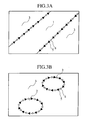
- the direction of the edge is therefore as shown in FIG. 3 according to the definition of the embodiment.
- FIG. 3A is an enlarged view of the white line 1 and FIG. 3B is an enlarged view of the road stud 2.
- a blank dot represents an edge point 4 obtained and an arrow represents a direction 5 of the edge point. Since the edge direction is tilted to the left in relation to the direction of higher luminance, the luminance on the right side in the direction of the edge is high, while that on the left side is low.
- the road stud 2 shown in FIG. 3B is circular; however, the shape may be a rectangle or other. A method of extracting edge points will be detailed later.
- step S3 those edge points that serve as noise are eliminated, while retaining lane marker edge points as many as possible.
- the edge points that are oriented toward the vanishing point are selected by taking advantage of the fact that the lane marker is oriented toward the vanishing point. That is, those edge points that are not oriented toward the vanishing point are eliminated.
- a method used for making this selection is as follows. An equation for a straight line that passes through x and y and has an angle of ⁇ is first obtained from the information x, y, and ⁇ of the edge point. The distance between the straight line and the vanishing point is then obtained.
- the edge point is oriented toward the vanishing point and left as a candidate for the lane marker.
- Providing the predetermined threshold value allows the angle of the edge point to be extracted to have a certain amount of latitude. This provides an advantage of reducing the effect of a deviated angle caused by noise.
- Edge points that are originally close to the vanishing point are then eliminated regardless of their values of ⁇ . These edge points that are originally close to the vanishing point are those of an object located far away in an actual space. The lane marker is therefore projected as an extremely small element near the vanishing point on the screen. As a result, there are a small number of edge points of the lane marker near the vanishing point. This makes for a higher ratio of edge points representing objects other than the lane marker that are noise.
- a means of determining whether or not an edge point is close to the vanishing point is to simply calculate the distance between the vanishing point and the edge point on the screen. Specifically, all edge points that are located inside a circle or an ellipse with a predetermined radius around the vanishing point are eliminated.
- Another method that takes into account a calculation cost is to use the difference in a y-coordinate value. According to this method, the difference in the y-coordinate value between the vanishing point and the edge point is obtained. If the difference is a predetermined threshold value or less, then the edge point is considered to be close to the vanishing point and thus eliminated.
- the reason why the y-coordinate value is used is as follows. That is, for the lane marker on the road surface, an angle of depression from the camera can be obtained from a y-coordinate position thereof on the screen, which makes it possible to find the actual distance together with the height at which the camera is installed.
- FIGS. 4A and 4B show the results of selection of edge points when the vanishing point is located on an upper right side for the white line 1 and the road stud 2, respectively.
- the white line 1 substantially all of the edge points 4 are left.
- the road stud 2 on the other hand, almost all of the edge points 4 are eliminated.
- the edge points on a left end and on a right end, which have the same directional component as the white line 1, are left.
- This selection procedure eliminates most of the edge points that serve as noise of elements other than the lane marker, while leaving those edge points that run parallel with the lane marker. They are subjected to discrimination through analyses made in steps S4 and onward.
- the position of the vanishing point is not constant and varies for varying degrees of tilt of the host vehicle with respect to the lane, requiring calculation whenever a frame changes. In this step, however, the position of the vanishing point obtained in a preceding frame is used. This takes advantage of the fact that the position of the vanishing point does not change considerably within a short period of time.
- a default position of the vanishing point which has been previously defined from the position at which the camera is installed, is used at the very start of the processes. The method used to find the vanishing point will be explained in the description of step S6.
- step S4 the angles of the right and left lane markers of the host vehicle are estimated using the angle information of the edge points extracted in step S3.
- an edge angle histogram is used for analysis. More specifically, a histogram is created of all pixels that make up the edges according to each edge angle. In this edge angle histogram, pixels of an edge angle in a given direction available in large numbers appear as a peak. For example, assume that only a single straight white line exists in the image. Then, peaks appear for certain particular edge angles. A histogram is therefore created as shown in FIG. 5B and, from among the angles that form peaks, respective angles ⁇ 1 and ⁇ r of the left and right lane markers are estimated. In the examples shown in FIGS.
- step S5 straight lines of the left and right lane markers are estimated based on the distribution of edge points having angles of ⁇ 1 and ⁇ r. It is of course possible that the lane marker is curved at a curve. Effects of this curve can nonetheless be substantially ignored. This is because of the following reason.
- step S3 all edge points near the vanishing point are elminated and only the edge points of the lane marker on the front near the host vehicle are used. This allows the characteristic, which each of parts of a curve can be approximated by a straight line, to be used.
- Hough transform is used for linear approximation of the lane marker.
- the Hough transform is a technique that derives a straight line passing through the greatest number of points from an arrangement of a number of points. It is a common technique employed in image processing and the explanation thereof is omitted. The procedure up to linear approximation of the lane marker will be explained with reference to FIG. 6.
- FIG. 6 shows an example of the white line on the left side of the host vehicle.
- the white line involves edges on both the left and right ends. Hough transform is therefore carried out for each of the edge point on the left end and the edge point on the right end.
- the angle of the left white line obtained in step S4 is ⁇ 1.
- an orientation angle of the edge point on the right end is ⁇ 1 and the orientation angle of the edge point on the left end is ⁇ 1 + 180 as it is opposite to the former.
- Hough transform is then performed from the distribution of edge points having angles close to ⁇ 1 and the straight line obtained through the Hough transform is designated as a line 62 on the right side of the white line.
- the Hough transform is performed from the distribution of edge points having angles close to ⁇ 1 + 180 and the straight line obtained through the Hough transform is designated as a line 61 on the left end of the white line. From two straight lines obtained through these procedures, a centerline 63 is obtained and designated as the left white line.
- Least squares approximation or the like may be used instead of Hough transform used for the linear approximation.
- the vanishing point is calculated.
- the vanishing point may be calculated as an intersection point between the left and right lane marker straight lines calculated in step S5.
- the vanishing point is generally placed in a curved direction when the lane marker curves at a curve. Far edge points are, however, ignored according to the embodiment and the intersection point of straight lines approximated from the lane markers in front is designated as the vanishing point.
- the vanishing point obtained in this manner less fluctuates due to the curve. It is then possible to limit the range of fluctuations, making for an easy estimation analysis of the position of the vanishing point.
- An output of results of recognition is produced in step S7.
- the information to be output is the amount of deviation S of the host vehicle in relation to the lane (FIG. 7).
- the amount of deviation S can range from -1 to 1. It is 0 if a host vehicle 71 runs along the center of the lane (FIG. 7A), 1 if the vehicle 71 is on the right lane marker (FIG. 7B), and -1 if the vehicle 71 is on the left lane marker (FIG. 7C).
- the amount S can be obtained using equation (1) and the angle formed by two linear approximated lines 81 shown in FIG. 8.
- FIGS. 9A through 9E depict the steps described in the foregoing paragraphs. Processing performed by the lane marker recognition method will be once again explained with reference to FIGS. 9A through 9E.
- FIG. 9A shows the results of edge points extracted in step S2 from the image captured through the camera.
- FIGS. 9A through 9E use a segment to represent each of the edge points so that the orientation of each edge point can be readily understandable.
- FIG. 9B shows the state in the middle of step S3, in which all edge points included in a nearby area 91 of a vanishing point 10 calculated in the preceding frame are eliminated.
- FIG. 9C shows the state in which the edge points that are not oriented toward the vanishing point are removed.
- FIG. 9A shows the results of edge points extracted in step S2 from the image captured through the camera.
- FIGS. 9A through 9E use a segment to represent each of the edge points so that the orientation of each edge point can be readily understandable.
- FIG. 9B shows the state in the middle of step
- FIG. 9D shows the state, in which the angle histogram is analyzed and only the edge points having angles of high frequencies of occurrence and meeting the lane width condition are extracted in step S4.
- the angles ⁇ nl and ⁇ nr of the adjacent lane markers are left; however, only ⁇ l and ⁇ r suffice.
- FIG. 9E shows the results of Hough transform performed for each angle to obtain the linear approximated lines 81.
- the vanishing point 10 is updated to the intersection point between the linear approximated lines 81.
- the lane recognition method according to the embodiment performs processing for recognition without distinguishing white lines from road studs, which makes the method effective for a road having both white lines and road studs installed therein.
- the method is able to detect edge points of the lane marker, regardless of whether it is the white line or the road stud. It is therefore important that the image be acquired so as to yield a difference in luminance even of road studs, thereby reducing the threshold value for edge detection sufficiently low.
- the edge detection technique will be explained.
- a variety of methods are available for detecting edge positions only. Available as methods for calculating the orientation component of the edge as well as position are the method using a Sobel filter, a two-dimensional zero-crossing method and the like.
- the method using the 3x3 Sobel filter will be explained according to the embodiment.
- each of the nine pixel values surrounding a specific pixel in question is multiplied by a corresponding coefficient as shown in FIG. 11. Then, the results are summed up to arrive at edge intensity. Two coefficient matrices in the vertical and horizontal directions are used to perform this processing.
- G ⁇ (Gx 2 + Gy 2 )
- the pixel value G represents the intensity of the edge. The greater the value is, the greater the difference in luminance in the area surrounding that particular portion is. If the value of G is greater than a predetermined threshold value for edge extraction, the pixel at that particular portion is extracted as an edge point.
- the white line 1 generally has a greater difference in luminance from the road surface 3. No problem therefore arises even from setting the edge extraction threshold value arbitrarily. With the road stud 2, however, it has only a small difference in luminance from the road surface 3 in many cases. It is therefore necessary that the edge extraction threshold value be set to a sufficiently low level to prevent failure to extract points.
- the edge angle ⁇ is obtained from the directional components Gx and Gy of edge intensity using the following equation (4).
- the angle ⁇ represents the orientation of the edge on the screen, ranging from 0 degrees to a value less than 360 degrees as described earlier.
- the orientation of the edge is a direction tilted by 90 degrees to the left in relation to the direction of high luminance.
- the camera as the input means be installed at a level as high as practically feasible to command a surrounding view. It is still possible, however, that the camera can be installed only at a low level as when mounting it in a vehicle with a low vehicle height. The installed height of the camera is low in such cases. Then, the angle formed by edge components 121 of the left and right lane markers of the cruising lane shown on the screen becomes so wide that the edge components 121 run nearly horizontally as shown in FIG. 12A. At this time, the edge points of edge components 122 representing noise of an adjoining lane marker, a guardrail, and other vehicles running on the neighboring lanes also run nearly horizontally.
- preprocessing is performed to change the ratio of width to height of the input image. More specifically, the input image may be compressed sidewise, or stretched in the vertical direction to create a vertically oriented image as compared with the original input image, as shown in FIG. 12B. This processing is accomplished by affine transformation. Through affine transformation, the difference between the edge angle of the edge component 121 of the lane marker and that of the edge component 122 of other noise can be made greater.
- the lane marker recognition method according to the present invention allows a lane marker composed of not only white lines, but also road studs to be detected as long as there is an edge in the lane marker position. It is therefore possible to provide an algorithm that ensures stabilized recognition without having to discriminate the type of the lane marker.
Abstract
Description
- The present invention relates to a lane marker recognition method that uses road surface information obtained through a camera or other input means to recognize through image processing a vehicle running lane marker, and an apparatus using the same.
- A technique has conventionally been proposed in which image processing is employed to recognize a white line or other lane marker placed on a road so as to give a driver a warning if his or her vehicle deviates from a cruising lane. Another technique proposed uses a result of lane marker recognition for steering control of the vehicle.
- To recognize a white line through image processing, a common conventional approach sets a threshold value for luminance of an image so as to binarize the image, thereby recognizing a portion with a high luminance value as the white line. This approach uses a principle, in which, since the white line has a higher lightness than a surrounding road area, it accordingly exhibits a higher luminance value than the road area on the image. Setting the threshold value in luminance between the road area and the white line area allows the white line area only to be detected through binarization.
- If an image has a shadowy white line, however, the shadowed portion of the white line exhibits a lower luminance than the remaining portion of the white line. This hampers proper detection of the shadowed portion of the white line by this approach. There is still another problem, in which, if the threshold value is set at the luminance level that allows the approach to detect the shadowed portion of the white line, this causes the approach to detect also areas other than the white line.
- Japanese Patent Laid-open No. Hei 4-152406 discloses a technique, in which the threshold value is set based on a mean value and a maximum value of luminance of an entire image. This technique allows the threshold to be changed according to image conditions, which makes possible even more stabilized white line recognition.
- There is, however, a problem inherent in this technique. That is, if image conditions change due to weather or shadow, the technique is no longer able to detect the white line properly.
- There is another technique used to recognize the white line, in which an edge extraction is performed to recognize an outline of the white line, instead of binarization based on luminance. The edge extraction extracts a portion at which luminance of the image changes. Specifically, the technique uses the fact that the road area surrounding the white line is dark and there is a change in brightness at an edge of the white line. The technique then recognizes the portion, at which this change in brightness occurs, as the edge of the white line. Since the edge extraction is to detect the change in brightness, this offers an advantage that, even if brightness of a wide area of the image changes due to a change in weather, this is still able to detect the white line as long as there is a change in luminance at the edge of the white line. While being capable of extracting edges of the white line stably, the technique using the edge extraction is, however, likely extracts extra edge components on the road, such as a preceding vehicle and a rut.
- A technique that discriminates the edge of the white line from others is therefore important.
- Japanese Patent Laid-open No. Hei 11-195127 discloses a technique, in which edge angle information that is obtained when an edge point is obtained is used to determine the area enclosed by edge points that make an angle pair as the white line. This technique is based on the fact that a pair of edges comprising a left edge and a right edge of the white line is extracted from the white line and the difference in angle therebetween is approximately 180 degrees. If there are no edge points making an angle pair, the edge points can be eliminated from the white line.
- If the distribution of edge points of the white line to be recognized in lane markers forms a linear line, the position angle information of the edge point can be used to estimate the white line portion as in the technique disclosed in Japanese Patent Laid-open No. Hei 11-195127. This conventional technique is not, however, concerned with a road, in which road studs are installed as the lane marker. Thus, it is unable to recognize road studs.
- A technique is available for recognizing the road stud, in which a road stud pattern is registered as a template and the location of the road stud is detected through template matching. However, the size of the road stud on the image is generally small and the image of the road stud is highly susceptible to noise. This is a major obstacle to a stabilized recognition rate.
- If an algorithm for white lines differs from that for road studs and, to recognize a lane marker on a road, on which both white lines and road studs are installed, it is necessary to correctly identify the type of the lane marker. This means that correct recognition cannot be made if the type of the lane marker is incorrectly identified even with excellent algorithms provided for both the white lines and road studs. Hence, an overall recognition rate is reduced.
- It is therefore an object of the invention to provide an algorithm that is capable of stably recognizing a lane marker being composed of white lines or road studs without having to discriminate the type of the lane marker.
- To achieve the foregoing object, there is provided a lane marker recognition method according to the present invention comprising the steps of: inputting an image including a lane marker; extracting an edge point, which is a luminance change point in the image input in the image inputting step, and calculating an angle representing an orientation of each of the edge points extracted; and estimating the position of the lane marker by extracting, from among the edge points extracted in the edge extracting step, edge points the angles of which are a predetermined value or fall within a predetermined range of values.
- The edge extracting step is also provided with a step of extracting edge points that are located away from a vanishing point.
- The lane marker position estimating step also performs the following operation. That is, it creates a histogram of edge points by angle from edge points having an angle toward the vanishing point of those edge points located away from the vanishing point and sets the angle with a high frequency as a lane marker angle.
- Furthermore, the lane marker position estimating step performs linear estimation on a lane marker position from the distribution of edge points having the lane marker angle.
- Other objects and advantages of the invention will become apparent from the following description of embodiments with reference to the accompanying drawings in which:
- FIG. 1 shows a processing flow of the lane marker recognition method according to one embodiment of the present invention;
- FIGS. 2A and 2B are diagrams each showing a view ahead of a vehicle, including a lane marker obtained through an image input step according to the embodiment of the present invention;
- FIGS. 3A and 3B are diagrams each showing a direction of an edge point of the lane marker in the lane marker recognition method according to the embodiment of the present invention;
- FIGS. 4A and 4B are diagrams each illustrating an edge point that is oriented toward a vanishing point on the assumption that the vanishing point is located at an upper right side in the lane marker recognition method according to the embodiment of the present invention;
- FIGS. 5A and 5B are diagrams explaining an edge angle histogram of the lane marker recognition method according to the embodiment of the present invention;
- FIG. 6 is a diagram explaining linear approximation of the lane marker recognition method according to the embodiment of the present invention;
- FIGS. 7A, 7B, and 7C are diagrams illustrating an amount of deviation S in relation to the lane of the host vehicle in the lane marker recognition method according to the embodiment of the present invention;
- FIG. 8 is a drawing explaining how to find the amount of deviation S from the lane of the host vehicle in the lane marker recognition method according to the embodiment of the present invention;
- FIGS. 9A, 9B, 9C, 9D, and 9E each depict a step involved in the processing flow of the lane marker recognition method according to the embodiment of the present invention;
- FIG. 10 is a system configuration block diagram employing the lane marker recognition method according to the embodiment of the present invention;
- FIG. 11 shows coefficient matrices of the 3x3 Sobel filter method as one technique used to detect edge positions; and
- FIGS. 12A and 12B are diagrams explaining advance processing performed on the input image in the lane marker recognition method according to the embodiment of the present invention.
-
- FIG. 1 shows a processing flow of the lane marker recognition method according to the present invention.
- A lane marker recognition method according to one embodiment of the present invention includes the following steps: a vehicle forward image capturing step (step S1), or an image inputting step of inputting an image including a lane marker; an edge-with-angle-information extracting step (step S2) of taking a luminance change point of the image input through the vehicle forward image capturing step S1 as an edge and calculating an angle of orientation of the edge; an edge selecting step (step S3) of selecting edge points that are oriented toward a vanishing point of the road from the position and orientation angle of the edge point; lane marker position estimating steps (steps S4 to S5) of analyzing a distribution of positions of edge points aligned toward the vanishing point to determine the edge point of the lane marker; a step (step S6) of updating information about the vanishing point and the like; and a result output step (step S7) of producing an output of recognition results.
- The vanishing point, as the term is used in this specification, refers to an infinite far point at which the lane markers on the left and right of a host vehicle intersect each other.
- An overall configuration of a system to which the lane marker recognition method according to the embodiment of the present invention is applied will be first explained. A detailed description of each of the steps involved in the lane marker recognition method according to the embodiment of the invention will next be given.
- FIG. 10 shows a system, to which the embodiment of the invention is applied. A lane recognition unit 101 obtains a vehicle forward image through a camera 104 or other input means that is directed toward a front of a vehicle so as to transfer the image to an image processing means 105. The image processing means 105 follows the lane marker recognition method according to the invention to recognize the position of the lane marker on the image and calculate how much the host vehicle deviates from the lane. The amount of deviation will be explained with reference to FIG. 7. An amount of deviation S is 0 if a host vehicle 71 is traveling on the center of the lane, a positive value if the vehicle is traveling on the right side, and a negative value if the vehicle is traveling on the left side. The value can range from -1 to 1. The amount of deviation S calculated is transferred to a lane keep control unit 102. The lane keep control unit 102 controls a steering actuator 106 so as to return the vehicle to the center of the lane as necessary, or sounds a lane deviation warning unit 107 based on the amount of deviation S transferred thereto. That is, in the lane marker recognition method according to the embodiment of the invention, the image captured by the camera is analyzed, the position of the lane marker composed of white lines or road studs is detected, and the amount of deviation of the host vehicle with respect to the lane is calculated.
- The lane marker recognition method will be explained in detail with reference to FIG. 1.
- In step S1, the image ahead of the vehicle obtained through the camera as an input means is fetched and stored in an image memory in an image processing device. An absolute condition is that the image includes a lane marker composed of white lines or road studs as shown in FIG. 2. FIG. 2A shows an example of lane markers composed of white lines and FIG. 2B shows an example of lane markers composed of road studs.
- In step S2, the luminance change point of the input image stored in the image memory is extracted as the edge and further calculated as data appended with angle information about the edge. This data representing each of the edge points includes position information x and y, and angle information .
- Here, the position information is a value in pixels on the screen, while the angle information represents the direction of the edge on the screen, the value of which can range from 0 degrees to 360 degrees. According to the embodiment, the direction of the edge is defined as a direction that tilts by 90 degrees to the left in relation to the direction of higher luminance. To tilt the direction of the edge through 90 degrees in relation to the direction of higher luminance is to align the direction with the orientation of an outline by the edge. The embodiment is not concerned with the direction of tilt and the edge direction may be tilted to the right. Generally speaking, the luminance of white lines 1 and road studs 2 is relatively higher than that of a surrounding road surface 3. The direction of the edge is therefore as shown in FIG. 3 according to the definition of the embodiment.
- FIG. 3A is an enlarged view of the white line 1 and FIG. 3B is an enlarged view of the road stud 2. In FIGS. 3 A and 3B, a blank dot represents an edge point 4 obtained and an arrow represents a direction 5 of the edge point. Since the edge direction is tilted to the left in relation to the direction of higher luminance, the luminance on the right side in the direction of the edge is high, while that on the left side is low. The road stud 2 shown in FIG. 3B is circular; however, the shape may be a rectangle or other. A method of extracting edge points will be detailed later. There are a number of elements existing on actual road surfaces that are taken as edges in addition to the lane marker. They include a preceding vehicle, a trace of slippage and other contaminant, a pattern, a shade of a street tree and the like. All of these edges serve as unwanted noise for lane marker recognition. Noise is therefore separated in steps S3 and onward.
- In step S3, those edge points that serve as noise are eliminated, while retaining lane marker edge points as many as possible. To accomplish this task, only the edge points that are oriented toward the vanishing point are selected by taking advantage of the fact that the lane marker is oriented toward the vanishing point. That is, those edge points that are not oriented toward the vanishing point are eliminated. A method used for making this selection is as follows. An equation for a straight line that passes through x and y and has an angle of is first obtained from the information x, y, and of the edge point. The distance between the straight line and the vanishing point is then obtained. If the distance is smaller than a predetermined threshold value, it is determined that the edge point is oriented toward the vanishing point and left as a candidate for the lane marker. Providing the predetermined threshold value allows the angle of the edge point to be extracted to have a certain amount of latitude. This provides an advantage of reducing the effect of a deviated angle caused by noise. Edge points that are originally close to the vanishing point are then eliminated regardless of their values of . These edge points that are originally close to the vanishing point are those of an object located far away in an actual space. The lane marker is therefore projected as an extremely small element near the vanishing point on the screen. As a result, there are a small number of edge points of the lane marker near the vanishing point. This makes for a higher ratio of edge points representing objects other than the lane marker that are noise.
- Available as a means of determining whether or not an edge point is close to the vanishing point is to simply calculate the distance between the vanishing point and the edge point on the screen. Specifically, all edge points that are located inside a circle or an ellipse with a predetermined radius around the vanishing point are eliminated. Another method that takes into account a calculation cost is to use the difference in a y-coordinate value. According to this method, the difference in the y-coordinate value between the vanishing point and the edge point is obtained. If the difference is a predetermined threshold value or less, then the edge point is considered to be close to the vanishing point and thus eliminated.
The reason why the y-coordinate value is used is as follows. That is, for the lane marker on the road surface, an angle of depression from the camera can be obtained from a y-coordinate position thereof on the screen, which makes it possible to find the actual distance together with the height at which the camera is installed. - Removing edge points near the vanishing point in advance gives the effect of reducing noise. Through the procedure to select these edge points as described in the foregoing, it is possible to select only the edge points that are oriented toward the vanishing point of those edge points located on a front side away from the vanishing point. FIGS. 4A and 4B show the results of selection of edge points when the vanishing point is located on an upper right side for the white line 1 and the road stud 2, respectively. With the white line 1, substantially all of the edge points 4 are left. With the road stud 2, on the other hand, almost all of the edge points 4 are eliminated. However, the edge points on a left end and on a right end, which have the same directional component as the white line 1, are left. This makes possible the same processing that follows as with the white line. This selection procedure eliminates most of the edge points that serve as noise of elements other than the lane marker, while leaving those edge points that run parallel with the lane marker. They are subjected to discrimination through analyses made in steps S4 and onward. The position of the vanishing point is not constant and varies for varying degrees of tilt of the host vehicle with respect to the lane, requiring calculation whenever a frame changes. In this step, however, the position of the vanishing point obtained in a preceding frame is used. This takes advantage of the fact that the position of the vanishing point does not change considerably within a short period of time. A default position of the vanishing point, which has been previously defined from the position at which the camera is installed, is used at the very start of the processes. The method used to find the vanishing point will be explained in the description of step S6.
- In step S4, the angles of the right and left lane markers of the host vehicle are estimated using the angle information of the edge points extracted in step S3. According to the embodiment, an edge angle histogram is used for analysis. More specifically, a histogram is created of all pixels that make up the edges according to each edge angle. In this edge angle histogram, pixels of an edge angle in a given direction available in large numbers appear as a peak. For example, assume that only a single straight white line exists in the image. Then, peaks appear for certain particular edge angles. A histogram is therefore created as shown in FIG. 5B and, from among the angles that form peaks, respective angles 1 and r of the left and right lane markers are estimated.
In the examples shown in FIGS. 5A and 5B, a deviation of 180 degrees is ignored and, for any angle exceeding 180 degrees, the value of any of these angles, from which 180 degrees are subtracted, is used to create the histogram. With the white line 1 and the road stud 2, a pair of edges appears on the left end and the right end with a deviation of approximately 180 degrees from each other as shown in FIGS. 4A and 4B. These edges are paired up with each other to produce an effect of yielding peaks more readily. In effect, however, noise components very often form peaks and, to provide a markered difference from these peaks, the estimation is made using information about the lane width. Since the lane width remains substantially constant, it is possible to limit the combination of angles 1 and r of the left and right lane markers. If there are a number of lanes as in the example shown in FIG. 5A, use of an angle nl or nr of the adjacent lane marker allows 1 and r to be estimated. Also in this case, the fact that the lane width remains substantially constant is used. - In step S5, straight lines of the left and right lane markers are estimated based on the distribution of edge points having angles of 1 and r. It is of course possible that the lane marker is curved at a curve. Effects of this curve can nonetheless be substantially ignored. This is because of the following reason. In step S3, all edge points near the vanishing point are elminated and only the edge points of the lane marker on the front near the host vehicle are used. This allows the characteristic, which each of parts of a curve can be approximated by a straight line, to be used. Hough transform is used for linear approximation of the lane marker. The Hough transform is a technique that derives a straight line passing through the greatest number of points from an arrangement of a number of points. It is a common technique employed in image processing and the explanation thereof is omitted. The procedure up to linear approximation of the lane marker will be explained with reference to FIG. 6.
- FIG. 6 shows an example of the white line on the left side of the host vehicle. The white line involves edges on both the left and right ends. Hough transform is therefore carried out for each of the edge point on the left end and the edge point on the right end. Suppose that the angle of the left white line obtained in step S4 is 1. Then, it can be estimated that an orientation angle of the edge point on the right end is 1 and the orientation angle of the edge point on the left end is 1 + 180 as it is opposite to the former. Hough transform is then performed from the distribution of edge points having angles close to 1 and the straight line obtained through the Hough transform is designated as a line 62 on the right side of the white line. Similarly, the Hough transform is performed from the distribution of edge points having angles close to 1 + 180 and the straight line obtained through the Hough transform is designated as a line 61 on the left end of the white line. From two straight lines obtained through these procedures, a centerline 63 is obtained and designated as the left white line. These explanations made for the white line are also applicable to the road stud. Least squares approximation or the like may be used instead of Hough transform used for the linear approximation.
- In step S6, the vanishing point is calculated. The vanishing point may be calculated as an intersection point between the left and right lane marker straight lines calculated in step S5. The vanishing point is generally placed in a curved direction when the lane marker curves at a curve. Far edge points are, however, ignored according to the embodiment and the intersection point of straight lines approximated from the lane markers in front is designated as the vanishing point. The vanishing point obtained in this manner less fluctuates due to the curve. It is then possible to limit the range of fluctuations, making for an easy estimation analysis of the position of the vanishing point.
- An output of results of recognition is produced in step S7. The information to be output is the amount of deviation S of the host vehicle in relation to the lane (FIG. 7). The amount of deviation S can range from -1 to 1. It is 0 if a host vehicle 71 runs along the center of the lane (FIG. 7A), 1 if the vehicle 71 is on the right lane marker (FIG. 7B), and -1 if the vehicle 71 is on the left lane marker (FIG. 7C). The amount S can be obtained using equation (1) and the angle formed by two linear approximated lines 81 shown in FIG. 8.
- FIGS. 9A through 9E depict the steps described in the foregoing paragraphs. Processing performed by the lane marker recognition method will be once again explained with reference to FIGS. 9A through 9E. FIG. 9A shows the results of edge points extracted in step S2 from the image captured through the camera. FIGS. 9A through 9E use a segment to represent each of the edge points so that the orientation of each edge point can be readily understandable. FIG. 9B shows the state in the middle of step S3, in which all edge points included in a nearby area 91 of a vanishing point 10 calculated in the preceding frame are eliminated. FIG. 9C shows the state in which the edge points that are not oriented toward the vanishing point are removed. FIG. 9D shows the state, in which the angle histogram is analyzed and only the edge points having angles of high frequencies of occurrence and meeting the lane width condition are extracted in step S4. In the example, the angles nl and nr of the adjacent lane markers are left; however, only l and r suffice. FIG. 9E shows the results of Hough transform performed for each angle to obtain the linear approximated lines 81. The vanishing point 10 is updated to the intersection point between the linear approximated lines 81. As explained in the description made with reference to FIG. 9, the lane recognition method according to the embodiment performs processing for recognition without distinguishing white lines from road studs, which makes the method effective for a road having both white lines and road studs installed therein. It is, however, a major premise that the method is able to detect edge points of the lane marker, regardless of whether it is the white line or the road stud. It is therefore important that the image be acquired so as to yield a difference in luminance even of road studs, thereby reducing the threshold value for edge detection sufficiently low.
- The edge detection technique will be explained. A variety of methods are available for detecting edge positions only. Available as methods for calculating the orientation component of the edge as well as position are the method using a Sobel filter, a two-dimensional zero-crossing method and the like. The method using the 3x3 Sobel filter will be explained according to the embodiment.
- According to the method using the 3x3 Sobel filter, each of the nine pixel values surrounding a specific pixel in question is multiplied by a corresponding coefficient as shown in FIG. 11. Then, the results are summed up to arrive at edge intensity. Two coefficient matrices in the vertical and horizontal directions are used to perform this processing.
- Assume that the total sum in the vertical direction is Gx and that in the horizontal direction is Gy. A pixel value G of the pixel in question is given by equation (3).
- The pixel value G represents the intensity of the edge. The greater the value is, the greater the difference in luminance in the area surrounding that particular portion is. If the value of G is greater than a predetermined threshold value for edge extraction, the pixel at that particular portion is extracted as an edge point. The white line 1 generally has a greater difference in luminance from the road surface 3. No problem therefore arises even from setting the edge extraction threshold value arbitrarily. With the road stud 2, however, it has only a small difference in luminance from the road surface 3 in many cases. It is therefore necessary that the edge extraction threshold value be set to a sufficiently low level to prevent failure to extract points.
- The edge angle is obtained from the directional components Gx and Gy of edge intensity using the following equation (4).

- The angle represents the orientation of the edge on the screen, ranging from 0 degrees to a value less than 360 degrees as described earlier. The orientation of the edge is a direction tilted by 90 degrees to the left in relation to the direction of high luminance.
- Preprocessing to be performed on the input image to enhance the recognition rate will be explained. It is desirable that the camera as the input means be installed at a level as high as practically feasible to command a surrounding view. It is still possible, however, that the camera can be installed only at a low level as when mounting it in a vehicle with a low vehicle height. The installed height of the camera is low in such cases. Then, the angle formed by edge components 121 of the left and right lane markers of the cruising lane shown on the screen becomes so wide that the edge components 121 run nearly horizontally as shown in FIG. 12A. At this time, the edge points of edge components 122 representing noise of an adjoining lane marker, a guardrail, and other vehicles running on the neighboring lanes also run nearly horizontally. As a result, there is little difference between the edge angle of the edge components 122 of the noise and that of the edge components 121 of the lane markers. In this condition, according to the lane marker recognition method of the invention, it becomes difficult to remove noise by using the angle information of the edge point, resulting in the recognition rate being lowered.
- As a means for improving the recognition rate in such conditions, preprocessing is performed to change the ratio of width to height of the input image. More specifically, the input image may be compressed sidewise, or stretched in the vertical direction to create a vertically oriented image as compared with the original input image, as shown in FIG. 12B. This processing is accomplished by affine transformation. Through affine transformation, the difference between the edge angle of the edge component 121 of the lane marker and that of the edge component 122 of other noise can be made greater.
- This enhances accuracy in noise removal using the angle information of edge points, which leads to an improved recognition rate in the lane marker recognition method according to the invention. To achieve the same effect as that produced from the preprocessing, it is also possible to change the shape of an optics system, that is, a lens of the camera, a photoreceiver of the CCD and the like, thereby obtaining a vertically oriented image in the very beginning.
- The lane marker recognition method according to the present invention allows a lane marker composed of not only white lines, but also road studs to be detected as long as there is an edge in the lane marker position. It is therefore possible to provide an algorithm that ensures stabilized recognition without having to discriminate the type of the lane marker.
- While the invention has been described in its preferred embodiments, it is to be understood that the words which have been used are words of description rather than limitation and that changes within the purview of the appended claims may be made without departing from the true scope and spirit of the invention in its broader aspects.
Claims (9)
- A lane marker recognition method, comprising the steps of:inputting an image including a lane marker (S1);extracting (S2) an edge point (4), which is a luminance change point in the image input in the image inputting step, and calculating an angle representing an orientation of each of the edge points extracted (S3); andestimating a position of the lane marker (S4) by extracting, from among the edge points (4) extracted in the edge extracting step (S2), those edge points the angles of which are a predetermined value or fall within a predetermined range of values.
- The lane marker recognition method according to claim 1, wherein the predetermined value which the angles of the edge points (4) extracted in the lane marker position estimating step (S4) take or the predetermined range of values which the angles of the edge points extracted in the lane marker position estimating step (S4) fall within varies according to the position of each edge point.
- The lane marker recognition method according to claim 1, wherein the predetermined value which the angles of the edge points (4) extracted in the lane marker position estimating step (S4) take is the angle of a straight line connecting the edge point and a vanishing point (10) of a road or the predetermined range of values which the angles of the edge points (4) extracted in the lane marker position estimating step (S4) fall within is the range deviated 180 degrees from the angle of the straight line.
- The lane marker recognition method according to claim 3, wherein the lane marker position estimating step (S4) eliminates edge points that fall within a predetermined range from the vanishing point (10).
- The lane marker recognition method according to claim 3, wherein the lane marker position estimating step (S4) creates a histogram of edge points by angle from edge points having an angle oriented toward the vanishing point and estimates a lane marker based on the edge points having angles with a frequency of occurrence of a predetermined value or more.
- The lane marker recognition method according to claim 4, wherein the lane marker position estimating step (S4) creates a histogram of edge points (4) by angle from edge points having an angle oriented toward the vanishing point (10), of all the edge points (4) falling outside a predetermined range from the vanishing point (10), and estimates a lane marker based on the edge points having angles with a frequency of occurrence of a predetermined value or more.
- The lane marker recognition method according to claim 5, wherein the lane marker position estimating step (S4) limits all the angles with high frequencies as obtained from the histogram to the angles of left and right lane markers based on a lane width.
- The lane marker recognition method according to claim 7, wherein the lane marker position estimating process makes linear approximation of the lane marker position from a distribution of edge points having the angles of the lane markers.
- A lane marker recognition method, comprising the steps of:inputting an image including a lane marker (S1);changing in advance a ratio of width to height of the image input in the image inputting step;extracting (S2) an edge point (4), which is a luminance change point in the image changed in advance, and calculating an angle representing an orientation of each of the edge points extracted (S3); andestimating a position of the lane marker (S4) by extracting, from among the edge points (4) extracted in the edge extracting step (S4), those edge points the angles of which are a predetermined value or fall within a predetermined range of values.
Applications Claiming Priority (4)
| Application Number | Priority Date | Filing Date | Title |
|---|---|---|---|
| JP2001365493 | 2001-11-30 | ||
| JP2001365493 | 2001-11-30 | ||
| JP2002173569 | 2002-06-14 | ||
| JP2002173569A JP4016735B2 (en) | 2001-11-30 | 2002-06-14 | Lane mark recognition method |
Publications (2)
| Publication Number | Publication Date |
|---|---|
| EP1320072A2 true EP1320072A2 (en) | 2003-06-18 |
| EP1320072A3 EP1320072A3 (en) | 2007-03-28 |
Family
ID=26624776
Family Applications (1)
| Application Number | Title | Priority Date | Filing Date |
|---|---|---|---|
| EP02026837A Withdrawn EP1320072A3 (en) | 2001-11-30 | 2002-11-29 | Lane marker recognition method |
Country Status (3)
| Country | Link |
|---|---|
| US (1) | US7362883B2 (en) |
| EP (1) | EP1320072A3 (en) |
| JP (1) | JP4016735B2 (en) |
Cited By (6)
| Publication number | Priority date | Publication date | Assignee | Title |
|---|---|---|---|---|
| WO2007002964A2 (en) * | 2005-07-04 | 2007-01-11 | Advanced Computer Vision Gmbh-Acv | Method for lane recognition |
| DE102009003697A1 (en) * | 2009-03-30 | 2010-10-07 | Conti Temic Microelectronic Gmbh | Method and apparatus for lane detection |
| US8265872B2 (en) | 2008-09-08 | 2012-09-11 | Toyota Jidosha Kabushiki Kaisha | Road surface division mark recognition apparatus, and lane departure prevention apparatus |
| US8755967B1 (en) * | 2012-03-23 | 2014-06-17 | Google Inc. | Estimating road lane geometry using lane marker observations |
| US8902053B2 (en) | 2011-11-16 | 2014-12-02 | Industrial Technology Research Institute | Method and system for lane departure warning |
| DE102013205950B4 (en) * | 2012-04-09 | 2020-03-19 | GM Global Technology Operations, LLC (n.d. Ges. d. Staates Delaware) | Roadside detection method |
Families Citing this family (71)
| Publication number | Priority date | Publication date | Assignee | Title |
|---|---|---|---|---|
| US5877897A (en) | 1993-02-26 | 1999-03-02 | Donnelly Corporation | Automatic rearview mirror, vehicle lighting control and vehicle interior monitoring system using a photosensor array |
| US6822563B2 (en) | 1997-09-22 | 2004-11-23 | Donnelly Corporation | Vehicle imaging system with accessory control |
| US6891563B2 (en) | 1996-05-22 | 2005-05-10 | Donnelly Corporation | Vehicular vision system |
| US7655894B2 (en) | 1996-03-25 | 2010-02-02 | Donnelly Corporation | Vehicular image sensing system |
| US7038577B2 (en) | 2002-05-03 | 2006-05-02 | Donnelly Corporation | Object detection system for vehicle |
| JP3956926B2 (en) * | 2003-09-24 | 2007-08-08 | アイシン精機株式会社 | Road lane detection device |
| JP3864945B2 (en) * | 2003-09-24 | 2007-01-10 | アイシン精機株式会社 | Road lane detection device |
| JP4107587B2 (en) * | 2003-12-17 | 2008-06-25 | 三菱電機株式会社 | Lane recognition image processing device |
| US7526103B2 (en) | 2004-04-15 | 2009-04-28 | Donnelly Corporation | Imaging system for vehicle |
| JP4089911B2 (en) * | 2005-02-23 | 2008-05-28 | 三菱電機株式会社 | Image input device |
| JP4637618B2 (en) * | 2005-03-18 | 2011-02-23 | 株式会社ホンダエレシス | Lane recognition device |
| JP4616046B2 (en) * | 2005-03-22 | 2011-01-19 | 本田技研工業株式会社 | VEHICLE IMAGE PROCESSING SYSTEM, VEHICLE IMAGE PROCESSING METHOD, VEHICLE IMAGE PROCESSING PROGRAM, AND VEHICLE |
| JP4539415B2 (en) * | 2005-04-15 | 2010-09-08 | 株式会社デンソー | Image processing device |
| JP4659631B2 (en) * | 2005-04-26 | 2011-03-30 | 富士重工業株式会社 | Lane recognition device |
| JP4616068B2 (en) * | 2005-04-28 | 2011-01-19 | 本田技研工業株式会社 | Vehicle, image processing system, image processing method, and image processing program |
| JP4603421B2 (en) * | 2005-05-27 | 2010-12-22 | 本田技研工業株式会社 | Vehicle, image processing system, image processing method, and image processing program |
| JP2006350641A (en) * | 2005-06-15 | 2006-12-28 | Toyota Motor Corp | Parallel line detection method and parallel line detector |
| KR100666276B1 (en) | 2005-07-13 | 2007-01-10 | 현대자동차주식회사 | A alarming method while the vehicle gets out of a traffic lane |
| JP4185077B2 (en) * | 2005-07-15 | 2008-11-19 | 本田技研工業株式会社 | Vehicle, image processing system, image processing method, and image processing program |
| JP4731276B2 (en) * | 2005-10-20 | 2011-07-20 | 池上通信機株式会社 | Velocity measuring device, method and program |
| JP4584120B2 (en) * | 2005-11-21 | 2010-11-17 | トヨタ自動車株式会社 | Road marking line detection device, road marking line detection method, road marking line detection program |
| JP4731295B2 (en) * | 2005-11-29 | 2011-07-20 | 池上通信機株式会社 | Velocity measuring device, method and program |
| JP4572826B2 (en) * | 2005-12-06 | 2010-11-04 | トヨタ自動車株式会社 | Road marking line detection device |
| JP4607193B2 (en) * | 2005-12-28 | 2011-01-05 | 本田技研工業株式会社 | Vehicle and lane mark detection device |
| JP4248558B2 (en) * | 2006-03-24 | 2009-04-02 | トヨタ自動車株式会社 | Road marking line detection device |
| WO2008024639A2 (en) | 2006-08-11 | 2008-02-28 | Donnelly Corporation | Automatic headlamp control system |
| JP4813304B2 (en) * | 2006-09-19 | 2011-11-09 | 本田技研工業株式会社 | Vehicle periphery monitoring device |
| JP4222411B2 (en) * | 2006-11-08 | 2009-02-12 | 日本電気株式会社 | Vanishing point detection system, vanishing point detection method, and vanishing point detection program |
| KR100819047B1 (en) * | 2006-11-27 | 2008-04-02 | 한국전자통신연구원 | Apparatus and method for estimating a center line of intersection |
| JP2008168811A (en) * | 2007-01-12 | 2008-07-24 | Honda Motor Co Ltd | Traffic lane recognition device, vehicle, traffic lane recognition method, and traffic lane recognition program |
| US8462988B2 (en) * | 2007-01-23 | 2013-06-11 | Valeo Schalter Und Sensoren Gmbh | Method and system for universal lane boundary detection |
| JP4506790B2 (en) * | 2007-07-05 | 2010-07-21 | アイシン・エィ・ダブリュ株式会社 | Road information generation apparatus, road information generation method, and road information generation program |
| US8131098B2 (en) * | 2007-07-06 | 2012-03-06 | Panasonic Corporation | Image processing device, image processing method, image processing system, program, storage medium, and integrated circuit |
| JP4937030B2 (en) * | 2007-07-24 | 2012-05-23 | ルネサスエレクトロニクス株式会社 | Image processing apparatus for vehicle |
| US20090037039A1 (en) * | 2007-08-01 | 2009-02-05 | General Electric Company | Method for locomotive navigation and track identification using video |
| JP5012396B2 (en) * | 2007-10-16 | 2012-08-29 | 日産自動車株式会社 | White line detection device, parking and stopping support device, and white line detection method |
| JP4856656B2 (en) * | 2008-01-22 | 2012-01-18 | 富士重工業株式会社 | Vehicle detection device |
| JP5014237B2 (en) * | 2008-04-23 | 2012-08-29 | 本田技研工業株式会社 | Lane marker recognition device, vehicle, and lane marker recognition program |
| US8099213B2 (en) * | 2008-07-18 | 2012-01-17 | GM Global Technology Operations LLC | Road-edge detection |
| JP5123812B2 (en) * | 2008-10-10 | 2013-01-23 | 日立オートモティブシステムズ株式会社 | Road marking recognition system |
| JP5195377B2 (en) * | 2008-12-10 | 2013-05-08 | トヨタ自動車株式会社 | Lane boundary deriving device |
| CN101477692B (en) * | 2009-02-13 | 2012-08-22 | 阿里巴巴集团控股有限公司 | Method and apparatus for image characteristic extraction |
| US8284997B2 (en) * | 2009-03-11 | 2012-10-09 | Honeywell International Inc. | Vision-based vehicle navigation system and method |
| US8306269B2 (en) * | 2009-03-12 | 2012-11-06 | Honda Motor Co., Ltd. | Lane recognition device |
| JP5363920B2 (en) * | 2009-08-31 | 2013-12-11 | 富士重工業株式会社 | Vehicle white line recognition device |
| JP5868586B2 (en) * | 2009-11-04 | 2016-02-24 | ヴァレオ・シャルター・ウント・ゼンゾーレン・ゲーエムベーハー | Road characteristic analysis based on video image, lane detection, and lane departure prevention method and apparatus |
| JP5716671B2 (en) | 2009-11-25 | 2015-05-13 | 日本電気株式会社 | Runway recognition device, vehicle, runway recognition method, and runway recognition program |
| JP5350297B2 (en) * | 2010-03-17 | 2013-11-27 | クラリオン株式会社 | Vehicle attitude angle calculation device and lane departure warning system using the same |
| CN101916516B (en) * | 2010-08-13 | 2012-07-11 | 深圳市豪恩汽车电子装备有限公司 | Lane deviation recognition method |
| JP5276637B2 (en) * | 2010-09-08 | 2013-08-28 | 富士重工業株式会社 | Lane estimation device |
| JP5472137B2 (en) * | 2011-01-24 | 2014-04-16 | 株式会社デンソー | Boundary detection device and boundary detection program |
| JP5830876B2 (en) * | 2011-02-18 | 2015-12-09 | 富士通株式会社 | Distance calculation program, distance calculation method, and distance calculation device |
| KR101046677B1 (en) * | 2011-03-15 | 2011-07-06 | 동국대학교 산학협력단 | Methods for tracking position of eyes and medical head lamp using thereof |
| WO2012147187A1 (en) * | 2011-04-27 | 2012-11-01 | トヨタ自動車株式会社 | Periphery vehicle detection device |
| US9751529B2 (en) * | 2011-06-09 | 2017-09-05 | GM Global Technology Operations LLC | Lane sensing through lane marker identification for lane centering/keeping |
| CN103164851B (en) * | 2011-12-09 | 2016-04-20 | 株式会社理光 | Lane segmentation object detecting method and device |
| JP5887219B2 (en) * | 2012-07-03 | 2016-03-16 | クラリオン株式会社 | Lane departure warning device |
| JP5878090B2 (en) * | 2012-07-12 | 2016-03-08 | 本田技研工業株式会社 | Traveling line detector |
| CN103971081A (en) * | 2013-01-25 | 2014-08-06 | 株式会社理光 | Multi-lane detection method and system |
| CN104376297B (en) * | 2013-08-12 | 2017-06-23 | 株式会社理光 | The detection method and device of the line style Warning Mark on road |
| US9747507B2 (en) * | 2013-12-19 | 2017-08-29 | Texas Instruments Incorporated | Ground plane detection |
| KR101962700B1 (en) * | 2013-12-24 | 2019-03-28 | 주식회사 만도 | System and method for lane recognition using defog sensor |
| JP6130325B2 (en) * | 2014-04-24 | 2017-05-17 | 本田技研工業株式会社 | Road environment recognition device |
| EP3082063A1 (en) | 2015-04-17 | 2016-10-19 | Tata Consultancy Services Limited | Method and system for ground truth determination in lane departure warning |
| JP6358629B2 (en) * | 2016-06-28 | 2018-07-18 | 三菱ロジスネクスト株式会社 | forklift |
| WO2018151008A1 (en) * | 2017-02-14 | 2018-08-23 | 日本電気株式会社 | Image recognition system, image recognition method, and recording medium |
| US11089288B2 (en) * | 2017-09-11 | 2021-08-10 | Tusimple, Inc. | Corner point extraction system and method for image guided stereo camera optical axes alignment |
| US11158088B2 (en) | 2017-09-11 | 2021-10-26 | Tusimple, Inc. | Vanishing point computation and online alignment system and method for image guided stereo camera optical axes alignment |
| US11130497B2 (en) | 2017-12-18 | 2021-09-28 | Plusai Limited | Method and system for ensemble vehicle control prediction in autonomous driving vehicles |
| US11273836B2 (en) * | 2017-12-18 | 2022-03-15 | Plusai, Inc. | Method and system for human-like driving lane planning in autonomous driving vehicles |
| US20190185012A1 (en) | 2017-12-18 | 2019-06-20 | PlusAI Corp | Method and system for personalized motion planning in autonomous driving vehicles |
Citations (4)
| Publication number | Priority date | Publication date | Assignee | Title |
|---|---|---|---|---|
| US4970653A (en) * | 1989-04-06 | 1990-11-13 | General Motors Corporation | Vision method of detecting lane boundaries and obstacles |
| US5245422A (en) * | 1991-06-28 | 1993-09-14 | Zexel Corporation | System and method for automatically steering a vehicle within a lane in a road |
| JPH05288534A (en) * | 1992-04-14 | 1993-11-02 | Matsushita Electric Ind Co Ltd | Inclination detecting method |
| US6002793A (en) * | 1992-01-30 | 1999-12-14 | Cognex Corporation | Machine vision method and apparatus for finding an object orientation angle of a rectilinear object |
Family Cites Families (23)
| Publication number | Priority date | Publication date | Assignee | Title |
|---|---|---|---|---|
| US4819169A (en) * | 1986-09-24 | 1989-04-04 | Nissan Motor Company, Limited | System and method for calculating movement direction and position of an unmanned vehicle |
| US5247587A (en) * | 1988-07-15 | 1993-09-21 | Honda Giken Kogyo Kabushiki Kaisha | Peak data extracting device and a rotary motion recurrence formula computing device |
| JP2844242B2 (en) * | 1990-03-19 | 1999-01-06 | 本田技研工業株式会社 | Automatic traveling device |
| JP2754871B2 (en) * | 1990-06-01 | 1998-05-20 | 日産自動車株式会社 | Roadway detection device |
| JPH04152406A (en) | 1990-10-16 | 1992-05-26 | Toyota Motor Corp | Line detector |
| JP2850608B2 (en) | 1991-11-28 | 1999-01-27 | 日産自動車株式会社 | Roadway detection device for vehicles |
| US5987174A (en) * | 1995-04-26 | 1999-11-16 | Hitachi, Ltd. | Image processing apparatus for vehicles |
| JP3084208B2 (en) * | 1995-05-18 | 2000-09-04 | 株式会社日立製作所 | Image processing device |
| JP3556766B2 (en) * | 1996-05-28 | 2004-08-25 | 松下電器産業株式会社 | Road white line detector |
| JP3993259B2 (en) * | 1996-07-31 | 2007-10-17 | アイシン精機株式会社 | Image processing device |
| EP0827127B1 (en) * | 1996-08-28 | 2006-10-04 | Matsushita Electric Industrial Co., Ltd. | Local positioning apparatus, and method therefor |
| JPH10208047A (en) * | 1997-01-23 | 1998-08-07 | Nissan Motor Co Ltd | On-vehicle traveling environment recognizing device |
| JP3760426B2 (en) * | 1997-09-10 | 2006-03-29 | 矢崎総業株式会社 | Traveling lane detection method and apparatus |
| JP3800785B2 (en) * | 1998-01-06 | 2006-07-26 | スズキ株式会社 | White line recognition device |
| JP2986439B2 (en) * | 1998-01-12 | 1999-12-06 | 松下電器産業株式会社 | Vehicle image processing device |
| US6577334B1 (en) * | 1998-02-18 | 2003-06-10 | Kabushikikaisha Equos Research | Vehicle control |
| JP3463858B2 (en) * | 1998-08-27 | 2003-11-05 | 矢崎総業株式会社 | Perimeter monitoring device and method |
| JP3377753B2 (en) | 1998-08-28 | 2003-02-17 | 吉野石膏株式会社 | Edge angle detection device and edge angle detection method |
| DE19906863A1 (en) * | 1999-02-18 | 2000-10-19 | Nokia Mobile Phones Ltd | Procedure for navigating an object |
| JP2000259998A (en) * | 1999-03-12 | 2000-09-22 | Yazaki Corp | Back monitoring device for vehicle |
| JP2001101415A (en) * | 1999-09-29 | 2001-04-13 | Fujitsu Ten Ltd | Image recognizing device and image processor |
| JP2001134769A (en) * | 1999-11-04 | 2001-05-18 | Honda Motor Co Ltd | Object recognizing device |
| JP3733875B2 (en) * | 2000-09-29 | 2006-01-11 | 日産自動車株式会社 | Road white line recognition device |
-
2002
- 2002-06-14 JP JP2002173569A patent/JP4016735B2/en not_active Expired - Lifetime
- 2002-11-27 US US10/305,251 patent/US7362883B2/en not_active Expired - Lifetime
- 2002-11-29 EP EP02026837A patent/EP1320072A3/en not_active Withdrawn
Patent Citations (4)
| Publication number | Priority date | Publication date | Assignee | Title |
|---|---|---|---|---|
| US4970653A (en) * | 1989-04-06 | 1990-11-13 | General Motors Corporation | Vision method of detecting lane boundaries and obstacles |
| US5245422A (en) * | 1991-06-28 | 1993-09-14 | Zexel Corporation | System and method for automatically steering a vehicle within a lane in a road |
| US6002793A (en) * | 1992-01-30 | 1999-12-14 | Cognex Corporation | Machine vision method and apparatus for finding an object orientation angle of a rectilinear object |
| JPH05288534A (en) * | 1992-04-14 | 1993-11-02 | Matsushita Electric Ind Co Ltd | Inclination detecting method |
Non-Patent Citations (1)
| Title |
|---|
| GAMBA P ET AL: "Vanishing point detection by a voting scheme" PROCEEDINGS OF THE INTERNATIONAL CONFERENCE ON IMAGE PROCESSING (ICIP) LAUSANNE, SEPT. 16 - 19, 1996, NEW YORK, IEEE, US, vol. VOL. 1, 16 September 1996 (1996-09-16), pages 301-304, XP010202654 ISBN: 0-7803-3259-8 * |
Cited By (11)
| Publication number | Priority date | Publication date | Assignee | Title |
|---|---|---|---|---|
| WO2007002964A2 (en) * | 2005-07-04 | 2007-01-11 | Advanced Computer Vision Gmbh-Acv | Method for lane recognition |
| WO2007002964A3 (en) * | 2005-07-04 | 2007-04-12 | Advanced Comp Vision Gmbh Acv | Method for lane recognition |
| US8265872B2 (en) | 2008-09-08 | 2012-09-11 | Toyota Jidosha Kabushiki Kaisha | Road surface division mark recognition apparatus, and lane departure prevention apparatus |
| US8392115B2 (en) | 2008-09-08 | 2013-03-05 | Toyota Jidosha Kabushiki Kaisha | Road surface division mark recognition apparatus, and lane departure prevention apparatus |
| DE102009029243B4 (en) * | 2008-09-08 | 2013-04-25 | Toyota Jidosha Kabushiki Kaisha | Lane separation mark recognition device and lane departure prevention device |
| DE102009003697A1 (en) * | 2009-03-30 | 2010-10-07 | Conti Temic Microelectronic Gmbh | Method and apparatus for lane detection |
| US8842884B2 (en) | 2009-03-30 | 2014-09-23 | Conti Temic Microelectronic Gmbh | Method and device for lane detection |
| US8902053B2 (en) | 2011-11-16 | 2014-12-02 | Industrial Technology Research Institute | Method and system for lane departure warning |
| US8755967B1 (en) * | 2012-03-23 | 2014-06-17 | Google Inc. | Estimating road lane geometry using lane marker observations |
| US8948958B1 (en) | 2012-03-23 | 2015-02-03 | Google Inc. | Estimating road lane geometry using lane marker observations |
| DE102013205950B4 (en) * | 2012-04-09 | 2020-03-19 | GM Global Technology Operations, LLC (n.d. Ges. d. Staates Delaware) | Roadside detection method |
Also Published As
| Publication number | Publication date |
|---|---|
| JP2003228711A (en) | 2003-08-15 |
| US7362883B2 (en) | 2008-04-22 |
| US20030103650A1 (en) | 2003-06-05 |
| EP1320072A3 (en) | 2007-03-28 |
| JP4016735B2 (en) | 2007-12-05 |
Similar Documents
| Publication | Publication Date | Title |
|---|---|---|
| US7362883B2 (en) | Lane marker recognition method | |
| EP0827127B1 (en) | Local positioning apparatus, and method therefor | |
| CN107330376B (en) | Lane line identification method and system | |
| Srinivasa | Vision-based vehicle detection and tracking method for forward collision warning in automobiles | |
| US7091837B2 (en) | Obstacle detecting apparatus and method | |
| US9818301B2 (en) | Lane correction system, lane correction apparatus and method of correcting lane | |
| US6879706B2 (en) | Apparatus and method for detecting traffic lane mark for automotive vehicle | |
| KR100975749B1 (en) | Method for recognizing lane and lane departure with Single Lane Extraction | |
| US20020042676A1 (en) | Road lane marker recognition | |
| US8155381B2 (en) | Vehicle headlight detecting method and apparatus, and region-of-interest segmenting method and apparatus | |
| CN110555361A (en) | Image-based lane marker classification | |
| KR101176693B1 (en) | Method and System for Detecting Lane by Using Distance Sensor | |
| US8983126B2 (en) | Method and system for detecting vehicle position by employing polarization image | |
| JP2007179386A (en) | Method and apparatus for recognizing white line | |
| US20120212615A1 (en) | Far-infrared pedestrian detection device | |
| JP2002228423A (en) | Tire detecting method and device | |
| JP3589293B2 (en) | Road white line detection method | |
| Takahashi et al. | A robust lane detection using real-time voting processor | |
| JP3915621B2 (en) | Lane mark detector | |
| JPH05314396A (en) | Continuous line tracking device | |
| JP4671991B2 (en) | Lane mark recognition device | |
| JP3285575B2 (en) | Road region extraction device and method | |
| JPH08106323A (en) | Travel direction control unit | |
| JP2007293892A (en) | Lane marker recognition method | |
| CN110321828A (en) | A kind of front vehicles detection method based on binocular camera and vehicle bottom shade |
Legal Events
| Date | Code | Title | Description |
|---|---|---|---|
| PUAI | Public reference made under article 153(3) epc to a published international application that has entered the european phase |
Free format text: ORIGINAL CODE: 0009012 |
|
| AK | Designated contracting states |
Designated state(s): AT BE BG CH CY CZ DE DK EE ES FI FR GB GR IE IT LI LU MC NL PT SE SK TR |
|
| AX | Request for extension of the european patent |
Extension state: AL LT LV MK RO SI |
|
| PUAL | Search report despatched |
Free format text: ORIGINAL CODE: 0009013 |
|
| AK | Designated contracting states |
Kind code of ref document: A3 Designated state(s): AT BE BG CH CY CZ DE DK EE ES FI FR GB GR IE IT LI LU MC NL PT SE SK TR |
|
| AX | Request for extension of the european patent |
Extension state: AL LT LV MK RO SI |
|
| 17P | Request for examination filed |
Effective date: 20070928 |
|
| AKX | Designation fees paid |
Designated state(s): DE FR GB IT |
|
| 17Q | First examination report despatched |
Effective date: 20080423 |
|
| GRAP | Despatch of communication of intention to grant a patent |
Free format text: ORIGINAL CODE: EPIDOSNIGR1 |
|
| STAA | Information on the status of an ep patent application or granted ep patent |
Free format text: STATUS: THE APPLICATION IS DEEMED TO BE WITHDRAWN |
|
| 18D | Application deemed to be withdrawn |
Effective date: 20090818 |