EP1517155B1 - System and method for providing a telematics service having an AGPS function - Google Patents
System and method for providing a telematics service having an AGPS function Download PDFInfo
- Publication number
- EP1517155B1 EP1517155B1 EP04022312A EP04022312A EP1517155B1 EP 1517155 B1 EP1517155 B1 EP 1517155B1 EP 04022312 A EP04022312 A EP 04022312A EP 04022312 A EP04022312 A EP 04022312A EP 1517155 B1 EP1517155 B1 EP 1517155B1
- Authority
- EP
- European Patent Office
- Prior art keywords
- telematics
- information
- agps
- server
- telematics terminal
- Prior art date
- Legal status (The legal status is an assumption and is not a legal conclusion. Google has not performed a legal analysis and makes no representation as to the accuracy of the status listed.)
- Expired - Fee Related
Links
Images


Classifications
-
- G—PHYSICS
- G08—SIGNALLING
- G08G—TRAFFIC CONTROL SYSTEMS
- G08G1/00—Traffic control systems for road vehicles
- G08G1/09—Arrangements for giving variable traffic instructions
- G08G1/0962—Arrangements for giving variable traffic instructions having an indicator mounted inside the vehicle, e.g. giving voice messages
- G08G1/0968—Systems involving transmission of navigation instructions to the vehicle
-
- G—PHYSICS
- G01—MEASURING; TESTING
- G01S—RADIO DIRECTION-FINDING; RADIO NAVIGATION; DETERMINING DISTANCE OR VELOCITY BY USE OF RADIO WAVES; LOCATING OR PRESENCE-DETECTING BY USE OF THE REFLECTION OR RERADIATION OF RADIO WAVES; ANALOGOUS ARRANGEMENTS USING OTHER WAVES
- G01S19/00—Satellite radio beacon positioning systems; Determining position, velocity or attitude using signals transmitted by such systems
- G01S19/01—Satellite radio beacon positioning systems transmitting time-stamped messages, e.g. GPS [Global Positioning System], GLONASS [Global Orbiting Navigation Satellite System] or GALILEO
- G01S19/03—Cooperating elements; Interaction or communication between different cooperating elements or between cooperating elements and receivers
- G01S19/05—Cooperating elements; Interaction or communication between different cooperating elements or between cooperating elements and receivers providing aiding data
-
- G—PHYSICS
- G01—MEASURING; TESTING
- G01S—RADIO DIRECTION-FINDING; RADIO NAVIGATION; DETERMINING DISTANCE OR VELOCITY BY USE OF RADIO WAVES; LOCATING OR PRESENCE-DETECTING BY USE OF THE REFLECTION OR RERADIATION OF RADIO WAVES; ANALOGOUS ARRANGEMENTS USING OTHER WAVES
- G01S19/00—Satellite radio beacon positioning systems; Determining position, velocity or attitude using signals transmitted by such systems
- G01S19/01—Satellite radio beacon positioning systems transmitting time-stamped messages, e.g. GPS [Global Positioning System], GLONASS [Global Orbiting Navigation Satellite System] or GALILEO
- G01S19/13—Receivers
- G01S19/14—Receivers specially adapted for specific applications
-
- H—ELECTRICITY
- H04—ELECTRIC COMMUNICATION TECHNIQUE
- H04W—WIRELESS COMMUNICATION NETWORKS
- H04W4/00—Services specially adapted for wireless communication networks; Facilities therefor
- H04W4/02—Services making use of location information
Landscapes
- Engineering & Computer Science (AREA)
- Radar, Positioning & Navigation (AREA)
- Remote Sensing (AREA)
- Computer Networks & Wireless Communication (AREA)
- Physics & Mathematics (AREA)
- General Physics & Mathematics (AREA)
- Signal Processing (AREA)
- Position Fixing By Use Of Radio Waves (AREA)
- Mobile Radio Communication Systems (AREA)
Description
- The present invention relates generally to an apparatus for providing a telematics service, and more particularly to a telematics system including an AGPS (Assisted Global Positioning System) function and a mobile communication terminal.
- Telematics is a compound of "telecommunication" and "informatics". Telematics is a technique for providing a mobile communication service and a position tracking service to a vehicle so as to provide information about a vehicle accident, a vehicle burglary, a driving route, traffic and life information, and games in real time. Telematics systems provide services in relation to a present position of a user, so telematics systems are based on a GPS (global positioning system) capable of detecting the present position of the user.
- GPS has been designed for military use by the ministry of defense. However, some GPS functions have been permitted to be used by private businesses. The GPS satellite signals, which are permitted to be used by private businesses, are created by modulating signals, which are obtained by multiplying navigation data by a pseudo random noise code of each satellite, into a carrier. Navigation data is transmitted from the GPS satellite with a transmission speed of 50bps and enables the user to recognize a position of the GPS satellite. The navigation data includes information about a normal operating state of the satellite, parameters for calculating a satellite clock error, ephemeris information of the satellite, and compensating values for determining a time delay of signals caused by an ionospheric layer.
- A GPS receiver receives GPS satellite signals in order to demodulate the carrier and the pseudo random code, and to decode navigation data contained in the GPS satellite signals.
- A mobile communication terminal equipped with the GPS receiver determines its position by measuring a distance between a satellite and the mobile communication terminal, after precisely calculating a position of the corresponding satellite based on the navigation data. The distance between the satellite and the mobile communication terminal, which is called a "pseudo-range", may be obtained by calculating a wave arrive time from the satellite to the mobile communication terminal, after measuring a phase of the pseudo random network code of each satellite included in the GPS signals.
- In addition, different from a receipt manner for a general CDMA signal, signal searching and tracking processes must be simultaneously performed in carrier and code areas when receiving the GPS signal because the GPS signal is subject to a Doppler shift (few kHz) due to rapid movement of the satellite. Consequently, it takes a long time to measure an initial position by using the telematics system measuring the position based on the GPS signal. In addition, an alignment of the satellites is designed such that at least six GPS satellites may be observed from anywhere on the earth. However, a multi-path or an attenuation of the signal may occur due to obstacles, such as buildings or street trees. As a result, it is commonly for only three satellites or less are observed.
-
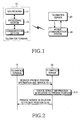
FIG. 1 is a block view illustrating a conventional telematics system. Referring toFIG. 1 , the conventional telematics system comprises atelematics terminal 10 including aGPS receiver 11, aprocessing section 13, and acommunication section 15, atelematics server 20, and amobile communication system 30. -
FIG. 2 is a schematic view illustrating a service procedure by using present position information of the conventional telematics system. Hereinafter, the service procedure using present position information of the conventional telematics system will be described with reference toFIGS. 1 and 2 . - Initially, the
telematics terminal 10 receives the GPS signal and measures a present position. Thetelematics terminal 10 then transmits the measuring result to thetelematics server 20 in order to request a service in relation to present position information in step S11. Accordingly, theGPS receiver 11 receives the GPS signal from the GPS satellite and transmits the GPS signal into theprocessing section 13. Theprocessing section 13 measures the present position of thetelematics terminal 10 and transmits present position information to thecommunication section 15. Thecommunication section 15 transmits present position information in the form of a message to thetelematics server 20. In addition, in a route guide service, thecommunication section 15 transmits destination information requested by the user to thetelematics server 20 by adding destination information to the present position information in the form of a message. - Therefore, the
telematics server 20 creates various types of service information in relation to the present position of thetelematics terminal 10 by using present position information transmitted from thetelematics terminal 10 instep S 13 and provides services in relation to the present position of thetelematics terminal 10 to thetelematics terminal 10 in step S15. - As described above, the conventional telematics system must sequentially search a search area, which consists of frequencies and codes with respect to each satellite, in order to enable the
telematics terminal 10 to obtain the GPS signal, if information is not provided. In addition, the conventional telematics system does not use satellite ephemeris information and user position/time information. - Therefore, the conventional telematics system takes a long time to measure an initial position of the telematics terminal, and a start time for the service may be delayed.
-
US 2002/0164998 A1 relates to providing position related information to a user of a wireless device. A position determination entity (PDE) identifies GPS satellites that are in view of the GPS receiver of a base station and with respect to that GPS receiver, determines the current position, Doppler frequencies and pseudo ranges of the identified GPS satellites. This GPS aiding information is transmitted to the wireless device through the base station. Because the wireless device is in communication with, and therefore proximate to, the base station, the GPS aiding information provides the wireless device with the approximate positions of the GPS satellites in view, thereby reducing the search frequency range. Once the GPS satellite signals are acquired, the geographic position of the wireless device may be determined. To this end, the wireless device simultaneously collects measurements from the GPS satellites and the base station and transmits the information to the PDE which carries out accurate position calculations using the data previously collected by the PDE. Thereafter, position related information and services can be provided to the user of the wireless device. -
WO 03/045084 A2 - According to
US 2003/0043069 A1 , a location information service receives CDMA base station information and a request for transmitting assist information from a cellular phone. The location information server then determines an approximate position of the cellular phone based on the CDMA base station information. Based on the approximate position of the cellular phone, the location information server computes the assist information which is useful to the cellular phone in searching GPS satellites and transmits the computed assist information to the cellular phone. -
WO 02/075349 A2 -
US 2001/0029425 A1 relates to real time vehicle guidance and traffic forecasting systems. - It is the object of the present invention to reduce the time needed for the initial positioning in a telematic system.
- This object is solved by the invention as defined in the independent claims.
- Embodiments are given in the dependent claims.
- Accordingly, the present invention has been designed to solve the above-mentioned problems occurring in the prior art, and a first advantage of the present invention is to provide a telematics system and a method for rapidly providing a telematics service by shortening an initial position measuring time of the telematics system.
- A second advantage of the present invention is to provide a telematics system and a method for improving a receive sensitivity of a GPS signal in a downtown area in which the GPS signal is attenuated, by utilizing satellite ephemeris information and user position information.
- To accomplish the above object, there is provided a telematics system comprising: a position determination entity server for storing and managing AGPS information including ephemeris information and compensation information of a satellite; a telematics terminal for receiving AGPS information from the position determination entity server to measure a present position of a moving object by using the AGPS information and requesting a telematics service by using the present position information; and a telematics server for receiving AGPS information from the position determination entity server in response to the telematics service request of the telematics, transmitting the AGPS information to the telematics terminal, and providing the telematics terminal with the telematics service requested by the telematics terminal by using the present position information of the telematics terminal.
- To accomplish the above object, there is provided a method for providing a telematics service, the method comprising the steps of receiving AGPS information including ephemeris information and compensation information of a satellite by using a telematics terminal in order to measure a present position of a moving object, measuring the present position of the moving object by using the AGSP information and time information of the telematics terminal, and receiving a position-related service based on present position of the moving object.
- The above and other objects, features, and advantages of the present invention will be more apparent from the following detailed description taken in conjunction with the accompanying drawings, in which:
-
FIG. 1 is a block view illustrating a structure of a conventional telematics system; -
FIG. 2 is a schematic view illustrating a service procedure using present position information of a conventional telematics system; -
FIG. 3 is a block view illustrating a structure of a telematics system according to an embodiment of the present invention; -
FIG. 4 is a schematic block view illustrating an AGPS module according to an embodiment of the present invention; -
FIG. 5 is a schematic block view illustrating a PDE server according to an embodiment of the present invention; -
FIG. 6 is a view illustrating a service procedure using present position information of a telematics system according to an embodiment of the present invention; and -
FIG. 7 is a flow chart illustrating a position calculating procedure of a telematics system according to an embodiment of the present invention. - Hereinafter, preferred embodiments of the present invention will be described in detail with reference to the accompanying drawings. In the following description of the present invention, the same reference numerals are used to designate the same or similar components and a detailed description of known functions and configurations incorporated herein will be omitted when it may make the subject matter of the present invention rather unclear.
-
FIG. 3 is a block view illustrating a structure of a telematics system according to an embodiment of the present invention. Referring toFIG. 3 , the telematics system of the present invention comprises atelematics terminal 100 including an AGPS (assisted global positioning system)module 110, aprocessing section 130, and acommunication section 150, atelematics server 200, a mobile communication system 300, and a PDE (position determination entity)server 400. - The
AGPS module 110 receives the GPS signal in order to measure a position of thetelematics terminal 100 by using predetermined satellite ephemeris information and error information. TheAGPS module 110 helps reduce a long warm-up time derived from a receipt of navigation data, so that the position of thetelematics terminal 100 can be detected in a shorter time. That is, the conventional GPS receiver must sequentially search a search area consisting of frequencies and codes with respect to each satellite, in order to obtain the GPS signal. However, when theAGPS module 110 is used, the GPS receiver (not shown, but included in the AGPS module 110) may substantially know position/time information of the user based on pre-measured satellite ephemeris information and error information. As a result, it is possible to predict a number and a Doppler shift value of the satellite observed from a position of the user. Accordingly, a number of satellites to be searched by the GPS receiver can be reduced and a time required for measuring the position of the terminal can be shortened. - The structure and operation of the mobile communication system 300 is widely known to one skilled in the art, so a detailed structure of the mobile communication system 300 is omitted in
FIG. 3 . In addition, the structure of the mobile communication system 300 will not be further described herein below. - The
AGPS module 110 of thetelematics terminal 100 illustrated inFIG. 3 enables thetelematics terminal 100 to perform AGPS functions. More specifically, thePDE server 400 stores and manages satellite ephemeris information and correction information, i.e., AGPS information. When thetelematics terminal 100 requests the AGPS information, thePDE server 400 receives the AGPS information from thetelematics server 200 and transmits the AGPS information to the telematics terminal through thetelematics server 200. At this time, as illustrated inFIG. 3 , thetelematics terminal 100 communicates, i.e., transfers data, with thetelematics server 200 through the mobile communication system 300. This kind of data communication may be applied to the entire following procedure. - In operation, the
telematics terminal 100 is mounted on a moving object, such as a vehicle, so as to measure the present position of the moving object. In addition, thetelematics terminal 100 transmits present position information to thetelematics server 200 in order to receive services utilizing the present position information in response to a request of the user. If the user has requested a route guide service, thetelematics terminal 100 transmits destination information to thetelematics server 200 together with present position information. Particularly, thetelematics terminal 100 requests AGPS information from thePDE server 400 through thetelematics server 200, and receives AGPS information in response to the request. Then, thetelematics terminal 100 measures the present position based on AGPS information. - As described above, the
telematics terminal 100 includes theAGPS module 110, theprocessing section 130, and thecommunication section 150. Theprocessing section 130 manages the operation of thetelematics terminal 100 based on an external operating signal. In particular, theprocessing section 130 transmits a control signal requesting AGPS information to theAGPS module 110 when the external operating signal requesting the present position is transmitted thereto. In addition, theprocessing section 130 receives data required for calculating the present position from theAGPS module 110, such as pre-measured satellite ephemeris information and error information, so as to transmit data request information to thetelematics server 200 through thecommunication section 150. - The
processing section 130 transmits the AGPS information, which has been transmitted from thetelematics server 200 through thecommunication section 150, to theAGPS module 110. Thereafter, theAGPS module 110 measures the present position by using the AGPS information. - Additionally, the
processing section 130 receives resultant data for the present position from theAGPS module 110 and transmits the resultant data to thecommunication section 150. Accordingly, thecommunication section 150 requests the service utilizing the present position information by transmitting present position information to thetelematics server 200. - If, for example, the route guide service has been requested, the
communication section 150 transmits destination information, which is determined by the external operating signal, to thetelematics server 200 together with present position information. At this time, thecommunication section 150 not only makes data communication between thetelematics terminal 100 and thetelematics server 200 through the mobile communication system 300, but also performs a conventional mobile communication function. Therefore, thecommunication section 150 must include a communication module capable of performing mobile communication, such as CDMA (code division multiple access) and UMTS (universal mobile telecommunication). - The
telematics server 200 manages all telematic services. More particularly, thetelematics server 200 provides a service utilizing present position information to thetelematics terminal 100, when thetelematics terminal 100 requests the service. In addition, when thetelematics terminal 100 requests AGPS information, thetelematics server 200 requests the AGPS information from thePDE server 400 in order to provide the AGPS information to thetelematics terminal 100. - Although the
telematics terminal 100 described above includes thecommunication section 150, it is also possible to use the telematics terminal without the communication module. In this case, thetelematics terminal 100 is connected to a conventional mobile communication terminal with an interface, such as a UART (universal asynchronous receiver/transmitter). When the mobile communication terminal is connected to the telematics terminal, the mobile communication terminal can receive the AGPS signal even if the mobile communication terminal has no GPS function. -
FIG. 4 is a schematic block view illustrating theAGPS module 110 according to an embodiment of the present invention. Referring toFIG. 4 , theAGPS module 110 of the present invention includes aGPS receiving section 111 and aposition calculating section 113. TheGPS receiving section 111 analyzes the GPS signal transmitted from the GPS satellite and transmits data thereof to theposition calculating section 113. More specifically, theGPS receiving section 111 reduces a search range for receiving the GPS signal by utilizing AGPS information transmitted from thePDE server 400, and as a result, it is possible to obtain the satellite signal within a shorter period of time. - The
position calculating section 113 measures the present position of thetelematics terminal 100 using the GPS signal transmitted from theGPS receiving section 111. Theposition calculating section 113 utilizes satellite position information among the AGPS information transmitted from thePDE server 400, and rapidly measures the present position of thetelematics terminal 100. -
FIG. 5 is a schematic block view illustrating thePDE server 400 according to an embodiment of the present invention. Referring toFIG. 5 , thePDE server 400 includes aGPS receiving section 410, aposition calculating section 420, and a telematics interface section (I/F) 430. TheGPS receiving section 410 receives GPS information required to calculate the position of thetelematics terminal 100 from the GPS satellite and transmits GPS information to theposition calculating section 420. Theposition calculating section 420 calculates the position of thetelematics terminal 100 using the GPS satellite signal transmitted thereto from theGPS receiving section 410 and related information thereof. That is, theposition calculating section 420 calculates the position of thePDE server 400 using the GPS signal transmitted from theGPS receiving section 410 and measures satellite ephemeris information observed from thePDE server 400 and error information thereof, in order to calculate the position of thetelematics terminal 100. - As described above, the
PDE server 400 provides thetelematics terminal 100 located in a management area of thePDE server 400 with satellite ephemeris information and position information of thetelematics terminal 100 so that thetelematics terminal 100 can rapidly measure its own present position. -
FIG. 6 is a view illustrating a service procedure using present position information of the telematics system according to an embodiment of the present invention. Referring toFIG. 6 , if a user requests present position information using thetelematics terminal 100, theprocessing section 130 requests an initialization of theAGPS module 110 in step S101. Then, when thetelematics server 200 connects to thetelematics terminal 100 through the mobile communication system, theAGPS module 110, which has been initialized, requests AGPS information required for calculating the present position from thePDE server 400 in steps S 103, S105, S107, and S109. More specifically, an AGPS information requesting message of theAGPS module 110 is transmitted to thetelematics server 200 through theprocessing section 130 and thecommunication section 150 of thenavigation terminal 100 in steps S103, S105, and S107, and thetelematics server 200 transmits the AGPS information requesting message to the PDE server 400 (S109). - AGPS information created from the
PDE server 400 in response to the AGPS information request message is transmitted to theAGPS module 110 from - the
PDE server 400, thetelematics server 200, thecommunication section 150, and theprocessing section 130 in steps S119, S121, S123, and S125. Although the mobile communication system is not illustrated inFIG. 6 , thetelematics server 200 communicates with thecommunication section 150 of thetelematics terminal 100 through the mobile communication system. - The AGPS information, which is requested by the
AGPS module 110 and transmitted from thePDE server 400, includes GPS sensitivity assistance, GPS ephemeris, location response, and GPS satellite health information. - Upon receiving the AGPS information, the
AGPS module 110 calculates the present position of thetelematics terminal 100 in step S127. However, in order to calculate the present position of thetelematics terminal 100, time information of thetelematics terminal 100 is required. Accordingly, theAGPS module 110 requests the time information from thecommunication section 150 performing a mobile communication function through theprocessing section 130 in steps S111 andS 113. In response to the request, thecommunication section 150 transmits AGPS time information to theAGPS module 110 through theprocessing section 130 in steps S 115 and S 117. - The
AGPS module 110, after receiving the AGPS information and the AGPS time information through above steps S103 to S125, calculates the present position of thetelematics terminal 100 by using AGPS information and AGPS time information in step S127. The method for calculating the present position of thetelematics terminal 100 using AGPS information and AGPS time information is already-known in the art (for example, Global Positioning System: Theory and ). - After calculating the present position of the
telematics terminal 100, theAGPS module 110 transmits the present position information of thetelematics terminal 100 to thetelematics server 200 through theprocessing section 130 and thecommunication section 150 in steps S129, S131, and S133. Thetelematics server 200, which receives present position information from thetelematics terminal 100, provides various services using the present position information, such as an emergency service (for example, E-911), a navigation service, and a traffic information service. Steps S129, S131, and S133, for transmitting present position information from thetelematics terminal 100 to thetelematics server 200, can be omitted depending on the type of service. For example, if thetelematics terminal 100 itself calculates the route for the navigation, steps S129, S 131 and S133 may be omitted. - After receiving present position information from the telematics terminal through steps S129, S131, and S133, the
telematics server 200 creates service information in relation to the present position (for example, an optimal route) by using the present position information in step S135, and provides such service information to thetelematics terminal 100 in steps S137 and S139. The optimal route may be calculated through various methods, which are well-known in telematics and navigation fields, and therefore, not described herein. -
FIG. 7 is a flow chart illustrating a position calculating procedure of a telematics system according to an embodiment of the present invention. That is, a procedure for calculating the present position of the AGPS module 110 (referred toFIG. 6 ) is illustrated inFIG. 7 . - Referring to
FIGS. 6 and7 , if an AGPS start command is input into theAGPS module 110 for calculating the present position in step S210, theAGPS module 110 requests information required for operating the AGPS from thePDE server 400 in step S220. As described above, the information includes GPS sensitivity assistance, GPS ephemeris, location response, and GPS satellite health information. In addition, theAGPS module 110 requests time information from thecommunication section 150 in order to rapidly measure the present position in step S230. TheAGPS module 110 then receives the AGPS information and the AGPS time information. At this time, if received AGPS time information has a precision degree ofminimum 1 second, a satellite search range can be reduced when receiving the GPS satellite signal. Thus, it is possible to obtain the satellite signal within a short time due to the reduced search range. - In step S240, the AGPS determines whether it has received the AGPS information and the AGPS time information. If the AGPS information and the AGPS time information has been received, the process proceeds to step S250. However, if the AGPS information and the AGPS time information has not been received, the
AGPS module 110 re-requests the AGPS information and the AGPS time information in step S220 and S230. - The
AGPS module 110 receiving AGPS information and AGPS time information obtains the signal from the satellite by using above information. Thus, thetelematics terminal 100 calculates the present position by utilizing the obtained signal in step S250. This calculation step S250 corresponds to step S127 of calculating the present position illustrated inFIG. 6 . Hereinafter, step 250 will be described in more detail. - The
AGPS module 110 calculates a position of the satellite, a moving speed of the satellite, and a relative distance and a relative speed of the satellite with respect to corresponding GPS receiver in step S251. Then, theAGPS module 110 determines a code capable of rapidly obtaining the GPS signal in an early stage, and a search range and a central search point of Doppler in step S252. Next, theAGPS module 110 predicts a GPS navigation bit in order to improve sensitivity of the GPS in step S253, and performs a search by increasing a synchronous integration period using the predicted GPS navigation bit. - In addition, the
AGPS module 110 performs a GPS signal tracking/detecting in step S254. As a result, theAGPS module 110 measures a pseudo-range between the satellite and the GPS receiver in step S255 and calculates the position of the GPS receiver (that is, the position of the user) using ephemeris information of the GPS satellite transmitted thereto from the server in step S256. - As described above, according to the present invention, the AGPS is utilized when measuring an initial position required for providing a telematics service. As a result, an initial position measuring time can be reduced, thereby advancing a start point of the telematics service. That is, a standby time of the user, which is required until the present position has been represented in the GPS receiver to obtain the initial position of the user, can be significantly reduced.
- In addition, because the present invention uses AGPS information, the reception sensitivity of the GPS signal in a downtown area, in which the GPS signal is attenuated, can be improved and the position of the user can be precisely measured. As a result, it is possible to significantly reduce a route departure phenomenon while a telematics routing service is being provided even if the user is in a GPS shadow area of the downtown where the GPS does not measure the position of the user.
- Furthermore, because the present invention utilizes the conventional telematics server and the conventional PDE server, conventional telematics services and AGPS functions can be achieved. Accordingly, the present invention may effectively provide the telematics services to the user.
- While the present invention has been illustrated and described with reference to certain preferred embodiments thereof, it will be understood by those skilled in the art that various changes in form and details may be made therein without departing from the scope of the present invention as defined by the appended claims.
Claims (19)
- A telematics system comprising:a position determination entity, PDE, server (400) for storing and managing AGPS, Assisted Global Positioning System, information including ephemeris information and compensation information of a satellite;a telematics terminal (100) for requesting (S103-S109) the AGPS information, receiving (S119-S125) the requested AGPS information, determining (S127, S250) present position information of the telematics terminal using the received AGPS information and time information of the telematics terminal, and requesting a telematics service using the present position information; anda telematics server (200) for providing (S137) the telematics terminal with the telematics service requested by the telematics terminal, using the present position information of the telematics terminal,wherein the telematics server is arranged for receiving (S119) the AGPS information from the PDE server and transmitting (S121) the AGPS information to the telematics terminal, thereby enabling the telematics terminal to receive the requested AGPS information from the PDE server through the telematics server,wherein the telematics terminal is arranged for transmitting (S129-S133) the present position information to the telematics serverwherein the telematics server is arranged for providing, when the telematics terminal requests the telematics service, the telematics service to the telematics terminal utilizing the present position information,thereby enabling the telematics server to receive the present position information from the telematics terminal, andwherein the telematics terminal is arranged for obtaining said time information of the telematics terminal by sending a request from an AGPS module (110) of the telematics terminal to a communication section (150) of the telematics terminal and receiving the requested time information of the telematics terminal at the AGPS module from the communication section, the communication section being arranged for performing a mobile communication function, wherein the AGPS module is arranged for sending said request after the telematics terminal has started to request the AGPS information, and receiving the requested time information of the telematics terminal before the telematics terminal has received the requested AGPS information.
- The telematics system as claimed in claim 1, wherein the position determination entity server is directly connected to the telematics server in order to transmit and receive the AGPS information to and from the telematics server.
- The telematics system as claimed in claim 1 or 2, wherein the PDE server comprises:a first GPS receiving section (410) for receiving a GPS signal from a GPS satellite,a first position calculating section (420) for calculating a position of the PDE server using the GPS signal received in the first GPS receiving section, measuring the ephemeris information and the error information of the satellite, and calculating a position of the telematics terminal utilizing the ephemeris information and the error information of the satellite, anda telematics interface section (430) for interfacing with the telematics server.
- The telematics system as claimed in one of claims 1 to 3, wherein the telematics terminal comprises:a processing section (130) for managing an operation of the telematics terminal based on an external operating signal,a communication section (150) for communicating with the telematics server under a control of the processing section in order to receive the AGPS information, andan AGPS module (110) for determining (S127, S250) the present position of the moving object using the AGPS information transmitted thereto from the communication section.
- The telematics system as claimed in claim 4, wherein the processing section transmits (S101) a control signal required for determining the present position to the AGPS module, receives (S103) an AGPS information request message required for calculating a position from the AGPS module, and transmits (S105, S107) the AGPS information request message to the telematics server through the communication section.
- The telematics system as claimed in claim 4 or 5, wherein the processing section receives (S129) the present position information from the AGPS module, transmits (S131, S133) present position information to the telematics server through the communication section, and requests a service utilizing the present position information.
- The telematics system as claimed in one of claims 4 to 6, wherein the processing section receives (S121, S123, S137, S139) the AGPS information and a service utilizing the present position information from the telematics server through the communication section in order to transmit (S125) the AGPS information to the AGPS module and to provide the service utilizing present position information to a user.
- The telematics system as claimed in one of claims 4 to 7, wherein the communication section comprises an individual mobile communication terminal connected to a mobile communication network.
- The telematics system as claimed in one of claims 4 to 8, wherein the communication section comprises a mobile communication module accommodated in the telematics terminal.
- The telematics system as claimed in one of claims 4 to 9, wherein the AGPS module comprises:a second GPS receiving section (111) for receiving a GPS signal from a GPS satellite by using the AGPS information; anda second position calculating section (113) for determining (S127, S250) the present position of the telematics terminal using the GPS signal received in the second GPS receiving section.
- The telematics system as claimed in one of claims 4 to 10, wherein the communication section obtains time information of the telematics system, synchronizes the time information of the telematics system with time information of the telematics terminal, and transmits (S115, S117) the synchronized time information to the AGPS module.
- The telematics system as claimed in claim 11, wherein the AGPS module calculates (S127, S250) a present position of the moving object by using the time information and AGPS information transmitted thereto from the communication section.
- A method for providing a telematics service in a telematics system having a position determination entity, PDE, server, a telematics terminal and a telematics server, the method comprising the steps of:i) requesting (S103-S109) AGPS, Assisted Global Positioning System, information including ephemeris information and compensation information of a satellite at the telematics terminal (100);ii) obtaining (S111-S117) time information of the telematics terminal from a communication section of the telematics terminal by sending (S111-S113) a request from an AGPS module (110) of the telematics terminal to a communication section (150) of the telematics terminal and receiving (S115-S117) the requested time information of the telematics terminal at the AGPS module from the communication section, the communication section being arranged for performing a mobile communication function wherein said request is sent after the telematics terminal has started to request the AGPS information;iii) receiving (S119-S125) the requested AGPS information at the telematics terminal (100) in order to measure a present position of the telematics terminal, the telematics terminal receiving the AGPS information from the PDE server through the telematics server after the AGPS module has received the requested time information;iv) measuring (S127, S250) the present position of the telematics terminal by using the AGPS information and said time information of the telematics terminal; andv) receiving (S137, S139) a position-related service based on the present position of the telematics terminal in response to transmitting the present position information from the telematics terminal to the telematics server to enable the telematics server to receive the present position information from the telematics terminal.
- The method as claimed in claim 13, wherein step iii) includes the substeps of transmitting (S103-S109) a signal requesting the AGPS information to a position determination entity server (400), which stores and manages the AGPS information including the ephemeris information and compensation information of the satellite, and receiving (S119-S125) the AGPS information from the position determination entity server.
- The method as claimed in claim 13 or 14, wherein the time information of the telematics terminal is synchronized with time information of a telematics system by means of a communication section (150).
- The method as claimed in one of claims 13 to 15, wherein the time information of the telematics terminal is received in the telematics terminal together with the AGPS information.
- The method as claimed in one of claims 13 to 16, wherein the position-related service includes an emergency rescue service by using information related to the present position of the moving object.
- The method as claimed in one of claims 13 to 17, wherein the position-related service includes a traffic information service by using information related to the present position of the moving object.
- The method as claimed in one of claims 13 to 18, wherein the position-related service includes a navigation service by using information related to the present position of the moving object.
Applications Claiming Priority (2)
| Application Number | Priority Date | Filing Date | Title |
|---|---|---|---|
| KR2003065400 | 2003-09-20 | ||
| KR10-2003-0065400A KR100526569B1 (en) | 2003-09-20 | 2003-09-20 | Apparatus and method for providing telematics service having agps function |
Publications (3)
| Publication Number | Publication Date |
|---|---|
| EP1517155A2 EP1517155A2 (en) | 2005-03-23 |
| EP1517155A3 EP1517155A3 (en) | 2006-04-12 |
| EP1517155B1 true EP1517155B1 (en) | 2011-06-29 |
Family
ID=34192256
Family Applications (1)
| Application Number | Title | Priority Date | Filing Date |
|---|---|---|---|
| EP04022312A Expired - Fee Related EP1517155B1 (en) | 2003-09-20 | 2004-09-20 | System and method for providing a telematics service having an AGPS function |
Country Status (4)
| Country | Link |
|---|---|
| US (1) | US7330789B2 (en) |
| EP (1) | EP1517155B1 (en) |
| KR (1) | KR100526569B1 (en) |
| CN (1) | CN1310036C (en) |
Families Citing this family (15)
| Publication number | Priority date | Publication date | Assignee | Title |
|---|---|---|---|---|
| KR100617787B1 (en) * | 2004-06-29 | 2006-08-28 | 삼성전자주식회사 | Gps receiver for detecting jammer using fast fourier transform and therefor method |
| KR100716882B1 (en) * | 2005-01-07 | 2007-05-09 | 주식회사 현대오토넷 | System and method for sharing positioning information using mobile communication system |
| KR100839342B1 (en) * | 2005-05-03 | 2008-06-17 | 에스케이 텔레콤주식회사 | Method and system for providing navigation service |
| US7788002B2 (en) * | 2005-08-08 | 2010-08-31 | The Boeing Company | Fault data management |
| EP1783509A1 (en) | 2005-11-08 | 2007-05-09 | The European GNSS Supervisory Authority | Method for providing assistance data to a mobile station of a satellite positioning system |
| US8020029B2 (en) * | 2006-02-17 | 2011-09-13 | Alcatel Lucent | Method and apparatus for rendering game assets in distributed systems |
| US7996019B2 (en) | 2006-12-26 | 2011-08-09 | Motorola Mobilty, Inc. | Intelligent location-based services |
| CN101115308B (en) * | 2007-06-19 | 2010-06-02 | 中兴通讯股份有限公司 | Method and system for implementing user intimacy safety in auxiliary global positioning process |
| US20090066565A1 (en) * | 2007-09-11 | 2009-03-12 | Mediatek Inc. | Gnss terminals automatically retrieving aiding data and aiding data systems |
| CN101159915B (en) * | 2007-11-16 | 2010-09-08 | 中兴通讯股份有限公司 | Position service servicing system and method for providing position information thereof |
| FR2945400B1 (en) * | 2009-05-05 | 2012-02-17 | St Ericsson Sa St Ericsson Ltd | METHOD AND DEVICE FOR UPDATING THE DATE AND TIME OF AN ELECTRONIC SYSTEM, IN PARTICULAR A CELLULAR MOBILE TELEPHONE |
| JP2012042279A (en) * | 2010-08-17 | 2012-03-01 | Sony Corp | Receiver, receiving method, and computer program |
| CN103200213A (en) * | 2012-01-09 | 2013-07-10 | 北京四维图新科技股份有限公司 | Data transmission method of remote information service system and data transmission device of remote information service system |
| US9354322B2 (en) * | 2013-05-15 | 2016-05-31 | General Motors Llc | Configuring Global Navigation Satellite System receiver units via over-the-air communications with control center |
| JP6696569B2 (en) * | 2016-05-23 | 2020-05-20 | 日本電気株式会社 | Service providing apparatus, service providing method and program |
Citations (2)
| Publication number | Priority date | Publication date | Assignee | Title |
|---|---|---|---|---|
| US20010029425A1 (en) * | 2000-03-17 | 2001-10-11 | David Myr | Real time vehicle guidance and traffic forecasting system |
| WO2002075349A2 (en) * | 2001-03-15 | 2002-09-26 | Qualcomm Incorporated | Time acquisition in a wireless position determination system |
Family Cites Families (15)
| Publication number | Priority date | Publication date | Assignee | Title |
|---|---|---|---|---|
| US6462708B1 (en) * | 2001-04-05 | 2002-10-08 | Sirf Technology, Inc. | GPS-based positioning system for mobile GPS terminals |
| US7009948B1 (en) | 2000-10-05 | 2006-03-07 | Ericsson Inc. | Systems and methods for providing GPS time and assistance in a communications network |
| US20020164998A1 (en) * | 2001-05-01 | 2002-11-07 | Saed Younis | System and method for providing position-based information to a user of a wireless device |
| JP3785968B2 (en) | 2001-08-30 | 2006-06-14 | 株式会社デンソー | Wireless communication terminal |
| US6900798B2 (en) * | 2001-08-31 | 2005-05-31 | Nokia Corporation | Power-conservation feature for liquid crystal display |
| AU2002219420A1 (en) | 2001-11-19 | 2003-06-10 | Nokia Corporation | Provision of location information |
| JP3656601B2 (en) * | 2001-12-27 | 2005-06-08 | 株式会社デンソー | GPS receiver system |
| US7398094B2 (en) * | 2002-01-16 | 2008-07-08 | Kyocera Wireless Corp. | Systems and methods for transmitting global positioning system information from a wireless communication system base station |
| KR100686741B1 (en) * | 2002-01-21 | 2007-02-27 | 노키아 코포레이션 | Provision of location information |
| US6950664B2 (en) * | 2002-01-24 | 2005-09-27 | Lucent Technologies Inc. | Geolocation using enhanced timing advance techniques |
| US6760582B2 (en) * | 2002-02-04 | 2004-07-06 | Qualcomm Incorporated | Method and apparatus for testing assisted position location capable devices |
| US6701253B2 (en) * | 2002-02-19 | 2004-03-02 | Eride, Inc. | Total correction strategy |
| US6999778B2 (en) * | 2002-07-03 | 2006-02-14 | Denso Corporation | Multipath assistance for pilot phase measurement processes |
| US6865395B2 (en) * | 2002-08-08 | 2005-03-08 | Qualcomm Inc. | Area based position determination for terminals in a wireless network |
| US20040198378A1 (en) * | 2002-08-20 | 2004-10-07 | General Motors Corporation | Method and system for amending wireless assisted global positioning system networks |
-
2003
- 2003-09-20 KR KR10-2003-0065400A patent/KR100526569B1/en not_active IP Right Cessation
-
2004
- 2004-08-12 US US10/917,122 patent/US7330789B2/en active Active
- 2004-09-20 EP EP04022312A patent/EP1517155B1/en not_active Expired - Fee Related
- 2004-09-20 CN CNB2004100825316A patent/CN1310036C/en not_active Expired - Fee Related
Patent Citations (2)
| Publication number | Priority date | Publication date | Assignee | Title |
|---|---|---|---|---|
| US20010029425A1 (en) * | 2000-03-17 | 2001-10-11 | David Myr | Real time vehicle guidance and traffic forecasting system |
| WO2002075349A2 (en) * | 2001-03-15 | 2002-09-26 | Qualcomm Incorporated | Time acquisition in a wireless position determination system |
Also Published As
| Publication number | Publication date |
|---|---|
| CN1598892A (en) | 2005-03-23 |
| EP1517155A2 (en) | 2005-03-23 |
| KR20050029290A (en) | 2005-03-24 |
| CN1310036C (en) | 2007-04-11 |
| US20050065725A1 (en) | 2005-03-24 |
| US7330789B2 (en) | 2008-02-12 |
| KR100526569B1 (en) | 2005-11-03 |
| EP1517155A3 (en) | 2006-04-12 |
Similar Documents
| Publication | Publication Date | Title |
|---|---|---|
| KR100616247B1 (en) | Reduced global positioning system receiver code shift search space for a cellular telephone system | |
| US7236126B2 (en) | AGPS system using NTP server and method for determining the location of a terminal using a NTP server | |
| EP2428812B1 (en) | System and method to obtain signal acquisition assistance data | |
| EP1237009B1 (en) | A method for positioning, a positioning system, and a mobile device | |
| US7463979B2 (en) | Method and apparatus for initializing an approximate position in a GPS receiver | |
| US6671620B1 (en) | Method and apparatus for determining global position using almanac information | |
| EP1330662B1 (en) | Gps satellite signal acquisition assistance system and method in a wireless communications network | |
| EP1517155B1 (en) | System and method for providing a telematics service having an AGPS function | |
| EP2434308B1 (en) | Method And System For Validating A Mobile Station Location Fix | |
| EP1260829A1 (en) | Autonomous calibration of a wireless-global positioning system | |
| JP2002525638A (en) | GPS location detection for mobile phones using the Internet | |
| JP2002508521A (en) | Method of measuring position of GPS receiver using estimated reference time | |
| US8638258B2 (en) | Method and system for a virtual wide area GNSS reference network | |
| JP2002214321A (en) | Gps positioning system | |
| KR100448574B1 (en) | GPS Receiver and Method for Determining Position of a Wireless Terminal | |
| JP2004125667A (en) | Positioning system | |
| KR20020053223A (en) | Device and method for determining search window to measure position of cellular phone in network-assisted gps system | |
| KR20070002527A (en) | Handset for offering position information, and method thereof | |
| KR100576018B1 (en) | Telematics system having agps function | |
| JP2002164834A (en) | False positional information detecting apparatus and method and mobile communication system equipped with transmission and reception function of positional information |
Legal Events
| Date | Code | Title | Description |
|---|---|---|---|
| PUAI | Public reference made under article 153(3) epc to a published international application that has entered the european phase |
Free format text: ORIGINAL CODE: 0009012 |
|
| 17P | Request for examination filed |
Effective date: 20040920 |
|
| AK | Designated contracting states |
Kind code of ref document: A2 Designated state(s): AT BE BG CH CY CZ DE DK EE ES FI FR GB GR HU IE IT LI LU MC NL PL PT RO SE SI SK TR |
|
| AX | Request for extension of the european patent |
Extension state: AL HR LT LV MK |
|
| PUAL | Search report despatched |
Free format text: ORIGINAL CODE: 0009013 |
|
| AK | Designated contracting states |
Kind code of ref document: A3 Designated state(s): AT BE BG CH CY CZ DE DK EE ES FI FR GB GR HU IE IT LI LU MC NL PL PT RO SE SI SK TR |
|
| AX | Request for extension of the european patent |
Extension state: AL HR LT LV MK |
|
| RIC1 | Information provided on ipc code assigned before grant |
Ipc: H04Q 7/22 20060101ALI20060220BHEP Ipc: G01S 1/00 20060101AFI20050112BHEP |
|
| 17Q | First examination report despatched |
Effective date: 20060721 |
|
| AKX | Designation fees paid |
Designated state(s): DE FR GB |
|
| RIC1 | Information provided on ipc code assigned before grant |
Ipc: G01S 19/05 20100101AFI20101124BHEP Ipc: G01S 19/14 20100101ALI20101124BHEP |
|
| GRAP | Despatch of communication of intention to grant a patent |
Free format text: ORIGINAL CODE: EPIDOSNIGR1 |
|
| GRAS | Grant fee paid |
Free format text: ORIGINAL CODE: EPIDOSNIGR3 |
|
| GRAA | (expected) grant |
Free format text: ORIGINAL CODE: 0009210 |
|
| AK | Designated contracting states |
Kind code of ref document: B1 Designated state(s): DE FR GB |
|
| REG | Reference to a national code |
Ref country code: GB Ref legal event code: FG4D |
|
| REG | Reference to a national code |
Ref country code: DE Ref legal event code: R096 Ref document number: 602004033251 Country of ref document: DE Effective date: 20110818 |
|
| PLBE | No opposition filed within time limit |
Free format text: ORIGINAL CODE: 0009261 |
|
| STAA | Information on the status of an ep patent application or granted ep patent |
Free format text: STATUS: NO OPPOSITION FILED WITHIN TIME LIMIT |
|
| 26N | No opposition filed |
Effective date: 20120330 |
|
| REG | Reference to a national code |
Ref country code: DE Ref legal event code: R097 Ref document number: 602004033251 Country of ref document: DE Effective date: 20120330 |
|
| REG | Reference to a national code |
Ref country code: FR Ref legal event code: PLFP Year of fee payment: 13 |
|
| REG | Reference to a national code |
Ref country code: FR Ref legal event code: PLFP Year of fee payment: 14 |
|
| REG | Reference to a national code |
Ref country code: FR Ref legal event code: PLFP Year of fee payment: 15 |
|
| PGFP | Annual fee paid to national office [announced via postgrant information from national office to epo] |
Ref country code: DE Payment date: 20190820 Year of fee payment: 16 |
|
| PGFP | Annual fee paid to national office [announced via postgrant information from national office to epo] |
Ref country code: FR Payment date: 20200824 Year of fee payment: 17 Ref country code: GB Payment date: 20200824 Year of fee payment: 17 |
|
| REG | Reference to a national code |
Ref country code: DE Ref legal event code: R119 Ref document number: 602004033251 Country of ref document: DE |
|
| PG25 | Lapsed in a contracting state [announced via postgrant information from national office to epo] |
Ref country code: DE Free format text: LAPSE BECAUSE OF NON-PAYMENT OF DUE FEES Effective date: 20210401 |
|
| GBPC | Gb: european patent ceased through non-payment of renewal fee |
Effective date: 20210920 |
|
| PG25 | Lapsed in a contracting state [announced via postgrant information from national office to epo] |
Ref country code: GB Free format text: LAPSE BECAUSE OF NON-PAYMENT OF DUE FEES Effective date: 20210920 Ref country code: FR Free format text: LAPSE BECAUSE OF NON-PAYMENT OF DUE FEES Effective date: 20210930 |