EP1528361A1 - Navigation routing system and method - Google Patents
Navigation routing system and method Download PDFInfo
- Publication number
- EP1528361A1 EP1528361A1 EP04011922A EP04011922A EP1528361A1 EP 1528361 A1 EP1528361 A1 EP 1528361A1 EP 04011922 A EP04011922 A EP 04011922A EP 04011922 A EP04011922 A EP 04011922A EP 1528361 A1 EP1528361 A1 EP 1528361A1
- Authority
- EP
- European Patent Office
- Prior art keywords
- navigation
- time
- route
- travel
- data
- Prior art date
- Legal status (The legal status is an assumption and is not a legal conclusion. Google has not performed a legal analysis and makes no representation as to the accuracy of the status listed.)
- Withdrawn
Links
Images

Classifications
-
- G—PHYSICS
- G08—SIGNALLING
- G08G—TRAFFIC CONTROL SYSTEMS
- G08G1/00—Traffic control systems for road vehicles
- G08G1/09—Arrangements for giving variable traffic instructions
- G08G1/0962—Arrangements for giving variable traffic instructions having an indicator mounted inside the vehicle, e.g. giving voice messages
- G08G1/0968—Systems involving transmission of navigation instructions to the vehicle
- G08G1/096833—Systems involving transmission of navigation instructions to the vehicle where different aspects are considered when computing the route
- G08G1/096838—Systems involving transmission of navigation instructions to the vehicle where different aspects are considered when computing the route where the user preferences are taken into account or the user selects one route out of a plurality
-
- G—PHYSICS
- G01—MEASURING; TESTING
- G01C—MEASURING DISTANCES, LEVELS OR BEARINGS; SURVEYING; NAVIGATION; GYROSCOPIC INSTRUMENTS; PHOTOGRAMMETRY OR VIDEOGRAMMETRY
- G01C21/00—Navigation; Navigational instruments not provided for in groups G01C1/00 - G01C19/00
- G01C21/26—Navigation; Navigational instruments not provided for in groups G01C1/00 - G01C19/00 specially adapted for navigation in a road network
- G01C21/34—Route searching; Route guidance
- G01C21/3453—Special cost functions, i.e. other than distance or default speed limit of road segments
- G01C21/3492—Special cost functions, i.e. other than distance or default speed limit of road segments employing speed data or traffic data, e.g. real-time or historical
-
- G—PHYSICS
- G08—SIGNALLING
- G08G—TRAFFIC CONTROL SYSTEMS
- G08G1/00—Traffic control systems for road vehicles
- G08G1/09—Arrangements for giving variable traffic instructions
- G08G1/0962—Arrangements for giving variable traffic instructions having an indicator mounted inside the vehicle, e.g. giving voice messages
- G08G1/0968—Systems involving transmission of navigation instructions to the vehicle
- G08G1/096833—Systems involving transmission of navigation instructions to the vehicle where different aspects are considered when computing the route
- G08G1/096844—Systems involving transmission of navigation instructions to the vehicle where different aspects are considered when computing the route where the complete route is dynamically recomputed based on new data
-
- G—PHYSICS
- G08—SIGNALLING
- G08G—TRAFFIC CONTROL SYSTEMS
- G08G1/00—Traffic control systems for road vehicles
- G08G1/09—Arrangements for giving variable traffic instructions
- G08G1/0962—Arrangements for giving variable traffic instructions having an indicator mounted inside the vehicle, e.g. giving voice messages
- G08G1/0968—Systems involving transmission of navigation instructions to the vehicle
- G08G1/096877—Systems involving transmission of navigation instructions to the vehicle where the input to the navigation device is provided by a suitable I/O arrangement
- G08G1/096883—Systems involving transmission of navigation instructions to the vehicle where the input to the navigation device is provided by a suitable I/O arrangement where input information is obtained using a mobile device, e.g. a mobile phone, a PDA
-
- G—PHYSICS
- G08—SIGNALLING
- G08G—TRAFFIC CONTROL SYSTEMS
- G08G1/00—Traffic control systems for road vehicles
- G08G1/09—Arrangements for giving variable traffic instructions
- G08G1/0962—Arrangements for giving variable traffic instructions having an indicator mounted inside the vehicle, e.g. giving voice messages
- G08G1/0968—Systems involving transmission of navigation instructions to the vehicle
- G08G1/096877—Systems involving transmission of navigation instructions to the vehicle where the input to the navigation device is provided by a suitable I/O arrangement
- G08G1/096888—Systems involving transmission of navigation instructions to the vehicle where the input to the navigation device is provided by a suitable I/O arrangement where input information is obtained using learning systems, e.g. history databases
Definitions
- the present invention relates generally to the field of navigation systems and, more particularly, to a navigation routing system and method.
- a global positioning system generally includes multiple orbiting satellites that transmit radio signals of a known format.
- a GPS receiver located on or near the earth's surface receives the signals from multiple GPS satellites (i.e., three geosynchronous satellites orbiting the earth) and computes the position of the receiver in three-dimensional space.
- vehicles equipped with a GPS receiver may input a selected destination to an onboard computer system to automatically determine routing information from a current location to a selected destination.
- GPS navigation systems do not accommodate multiple-stop or multiple-segment route determination.
- a navigation routing system comprises a navigation guide adapted to receive a travel itinerary from a requesting device.
- the travel itinerary comprises at least two route segments.
- the navigation guide is also adapted to automatically determine a time-optimized route segment sequence for the travel itinerary.
- a navigation routing method comprises receiving a navigation request for a travel itinerary from a requesting device where the travel itinerary comprises at least two route segments. The method also comprises automatically determining a time-optimized route segment sequence for the travel itinerary.
- a navigation routing system comprises a navigation guide adapted to receive a travel itinerary request from a user.
- the navigation guide is adapted to automatically determine a time-optimized origination time for the travel itinerary.
- FIGURE 1 is a diagram illustrating an embodiment of a navigation routing system in accordance with the present invention
- FIGURE 2 is a flow chart illustrating an embodiment of a navigation routing method in accordance with the present invention.
- FIGURE 3 is a flow chart illustrating another embodiment of a navigation routing method in accordance with the present invention.
- FIGURES 1-3 of the drawings like numerals being used for like and corresponding parts of the various drawings.
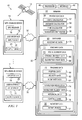
- FIGURE 1 is a diagram illustrating an embodiment of a navigation routing system 10 in accordance with the present invention.
- system 10 enables a user to input or select a plurality of desired travel stops or destinations for a particular travel itinerary.
- System 10 provides travel or navigation instructions to the user to enable the user to travel to the corresponding desired destinations.
- portable or mobile global positioning system (GPS)-enabled devices are used to analyze movement or flow rates of traffic for various routes associated with the desired travel destinations such that a time-optimized navigation route segment sequence for each leg or segment of the itinerary may be determined for traveling to each of the desired destinations.
- GPS global positioning system
- historical traffic and/or flow patterns may be evaluated to determine a time-optimized navigation route segment sequence for each segment of the travel itinerary.
- a user of a portable or mobile GPS-enabled electronic device may request travel directions and/or a navigation route segment sequence from a current location to a desired quantity of selected or identified destinations.
- the desired destinations may be associated with destinations for product delivery, tour destinations, shopping or errand destinations, or any other points of interest.
- a time-optimized navigation route segment sequence through the desired destinations may be provided for the request.
- a time-optimized origination time for beginning travel of the travel itinerary may also be provided.
- system 10 automatically determines a time-optimized order in which the destinations should be visited and determines a time-optimized navigation route to each of the destinations by evaluating various conditions affecting, or that may affect, travel along a desired travel itinerary.
- system 10 comprises a satellite network or system 12 for transmitting global positioning signals to GPS-enabled units or devices 14.
- Devices 14 may comprise a portable telephone, laptop computer, pager, personal digital assistant, or any other type of portable or mobile unit or device having a GPS receiver 16 for receiving the global positioning signals from satellite system 12.
- the term "portable” relates to any movable object such that global positioning information may be acquired relating to movement of GPS receiver 16 of such object.
- device 14 may comprise a motorized object (e.g., a car, truck, motorcycle, motorized scooter, etc.), a non-motorized object (e.g., a bicycle, inline skates, skateboard, etc.), or any other type of movable object equipped with a GPS receiver 16.
- each device 14 may also comprise a user interface 20 for communicating information to and from device 14.
- each user interface 20 may comprise an input device 22 and an output device 24.
- Input device 22 may comprise any device or object for enabling information to be input into device 14 including, but not limited to, a keypad, touch-based liquid crystal display screen, or microphone.
- Output device 24 may comprise any type of device or object for receiving the output of information from device 14 including, but not limited to, any device for providing audible and/or visual information to a user of device 14. However, it should be understood that device 14 may also comprise only receiver 16 to accommodate tracking of device 14 without accommodating input and/or output functionality via input device 22 or output device 24, respectively.
- system 10 also comprises a navigation controller 30 for receiving global positioning system information from devices 14 and providing to a requesting device 14 navigation instructions corresponding to requested or desired destinations.
- each device 14 is communicatively linked to navigation controller 30 via a wireless communication network 32 to accommodate information transfer between devices 14 and navigation controller 30.
- navigation controller 30 comprises a processor 40, an interface 42, and a memory 44.
- Interface 42 provides a platform for the communication of information between devices 14 and navigation controller 30.
- a user of device 14 may use input device 22 to input or select a desired travel itinerary comprising a plurality of destinations or travel stops. The request is transmitted via communication network 32 to navigation controller 30.
- GPS information corresponding to the requesting device 14 and other devices 14 is received by navigation controller 30 via communication networks 32.
- the determined navigation route segment sequence and navigation travel instructions are transmitted to the requesting device 14 via communication network 32.
- navigation controller 30 comprises a navigation guide 50 executable by processor 40.
- Navigation guide 50 may comprise software, hardware, or a combination of software and hardware.
- navigation guide 50 is illustrated as being stored in memory 44 so as to be executable by processor 40; however, it should be understood that navigation guide 50 may be otherwise stored, even remotely, so as to be accessible and executable by processor 40.
- navigation guide 50 comprises a route calculator 52, a distance calculator 54, a time calculator 56, and a navigation comparator 58.
- Route calculator 52, distance calculator 54, time calculator 56, and navigation comparator 58 may comprise software, hardware, or a combination of software and hardware.
- route calculator 52 identifies various available routes corresponding to the destinations designated by the user of one of devices 14 from a current location of the requesting device 14 to each of the designated destinations and available navigation routes between the designated destinations.
- Distance calculator 54 determines a travel distance corresponding to each available route identified by route calculator 52.
- Time calculator 56 determines a travel time for each available route identified by route calculator 52 using GPS-based tracking information for devices 14 traveling along the identified available routes.
- Navigation comparator 58 compares the available navigation routes and corresponding travel time information and selects a time-optimized navigation route segment sequence and associated navigation travel instructions for the request.
- navigation controller 30 also comprises a database 60 stored in memory 44.
- database 60 comprises geographic data 70, itinerary data 71, tracking data 72, navigation route data 74, navigation request data 76, historical data 77, schedule data 78, and inventory data 90.
- Geographic data 70 comprises information associated with the geographic characteristics of a particular region corresponding to the locations of devices 14.
- geographic data 70 may comprise information associated with street locations, street intersections, building or point-of-interest locations, traffic signal location information, and any other type of information corresponding to a particular geographic region corresponding to a location of devices 14.
- Geographic data 70 may be partitioned into various regions based on a regional location of a requesting device 14.
- corresponding regional geographic data 70 is acquired or accessed for determining the time-optimized navigation route segment sequence and navigation travel instructions for the user.
- Itinerary data 71 comprises information associated with a desired travel itinerary such as various travel destinations or locations designated or selected by the user.
- itinerary data 71 may comprise a listing of destinations associated with product deliveries, tour destinations, shopping destinations, or other points of interest.
- itinerary data 71 comprises route segment data 85 having information associated with each leg or segment of a desired travel itinerary 71.
- route segment data 85 comprises origination point data 86 and destination point data 88.
- Origination point data 86 comprises information associated with a current location of device 14 or a desired originating point of travel.
- Destination point data 88 comprises information associated with designated or selected travel destinations.
- the desired travel itinerary 71 may begin at origination point 86 and include a plurality of destination points 88 or, alternatively, the desired travel itinerary 71 may begin at origination point 86, include at least one destination point 88, and return to origination point 86.
- each route segment 85 of travel itinerary 71 may comprise travel between two destination points 88 or between a destination point 88 and an origination point 86.
- an interface associated with input device 22 may be configured to receive a plurality of points 86,88 selected or identified by a user and, upon completion of the selection or identification of points 86,88 by a user, input the points 86,88 to navigation controller 30 as a desired itinerary 71.
- Tracking data 72 comprises information associated with the location and movement of a particular device 14.
- tracking data 72 comprises position data 80, velocity data 82, and flow rate data 84.
- Position data 80 comprises information associated with a current position of a particular device 14 based on GPS information received from that device 14.
- Velocity data 82 comprises information associated with a traveling velocity of a particular device 14 based on multiple position locations of the particular device 14 measured over time.
- Flow rate data 84 comprises information associated with traffic flow for a particular navigation route based on velocity data 82 for each of a plurality of devices 14 traveling along a particular navigation route.
- Navigation route data 74 comprises information associated with each available navigation route identified by route calculator 52 in response to a request by a particular device 14.
- Navigation route data 74 may also comprise information associated with a time-optimized navigation route segment sequence for the travel itinerary 71 determined by navigation guide 50.
- Navigation route data 74 may also comprise time-optimized travel information for each route segment 85 of the travel itinerary 71.
- Navigation request data 76 comprises information associated with the particular travel itinerary 71 input or selected by a particular device 14. For example, navigation request data 76 may comprise information associated with a current position of device 14, origination point 86 of travel, and/or requested or desired destination points 88 for the particular device 14 travel.
- Historical data 77 comprises information associated with historical flow rates and/or traffic patterns for various navigation routes such that navigation guide 50 may predict flow rates and/or traffic patterns for various routes corresponding to the request. For example, navigation guide 50 may forecast or predict traffic flow rates and patterns for various navigation routes between destination points 88 and/or between origination point 86 and each destination point 88 for various time periods throughout the day to determine an optimal time-based route segment sequence for travel to the desired destination points 88.
- historical flow rate and/or traffic patterns may indicate that the particular destination point 88 should be visited early in the route segment sequence to avoid adverse traffic patterns and flow rates at a later time.
- historical data 77 may also indicate that traffic patterns and flow rates for particular navigation routes are less adverse at particular time periods throughout the day, thereby enabling navigation guide 50 to select a particular time period in the navigation route segment sequence for placing certain destination points 88.
- Schedule data 78 comprises information associated with known or scheduled travel conditions affecting traffic flow rates or patterns for the various available navigation routes.
- schedule data 78 may comprise information associated with scheduled road construction or lane closures along the available navigation routes.
- Inventory data 90 comprises information associated with active devices 92.
- active relates to devices 14 currently in use by a user such as any device being in a power "on” mode or other state capable of acting on a request made by a user.
- navigation guide 50 may select a time-optimized navigation route segment sequence based on tracking data 72 corresponding only to active devices 92.
- system 10 is configured to determine the time-optimized navigation route segment sequence based on the presumption that inactive devices 14 are not currently in transit along available navigation routes, thereby reducing the quantity of devices 14 that are tracked to determine the time-optimized navigation route.
- system 10 is configured such that GPS information may be acquired for any device 14, whether active or inactive, such that GPS information may be readily acquired by navigation controller 30 from any device 14 of interest along a particular navigation route in order to select a time-optimized navigation route segment sequence for the request.
- navigation controller 30 receives a request from a particular device 14 designating or selecting a particular travel itinerary 71.
- navigation controller 30 may request or automatically receive GPS information from the requesting device 14 or, in some embodiments, GPS information may be automatically transmitted by device 14 in connection with the travel request.
- system 10 may also be configured to automatically monitor and acquire GPS information corresponding to each GPS-enabled device 14 within a particular operating region.
- the GPS information corresponding to the requesting device 14 and other devices 14 in a particular operating region may be stored as tracking data 72 in database 60. From tracking data 72, navigation guide 50 may determine position data 80 corresponding to the requesting device 14. Additionally, information associated with the travel request received from a particular device 14 may be stored as navigation request data 76 in database 60.
- route calculator 52 accesses geographic data 70 and position data 80 to determine information corresponding to a current location of device 14 or, alternatively, an origination point 86 for travel, and the desired or designated destination points 88. Additionally, route calculator 52 uses geographic data 70 to identify available navigation routes from the origination point 86 to the desired destination point(s) 88, available navigation routes between destination points 88, and, in some circumstances, available navigation routes from destination point(s) 88 returning to origination point 86. The available navigation routes corresponding to the request may be stored as navigation route data 74 in database 60.
- Navigation controller 30 also obtains GPS information associated with other devices 14 in the operating region of the available navigation routes and stores the GPS information as tracking data 72. Using tracking data 72, position data 80 may be determined for each device 14 within the operating region. Additionally, monitoring of position data 80 for each device 14 over time may be used to determine velocity data 82 corresponding to each device 14.
- navigation guide 50 determines flow rate data 84 for each available navigation route identified by route calculator 52.
- navigation comparator 58 may access position data 80 for each device 14 to locate each device 14 corresponding to geographic data 70 for the operating region.
- Navigation comparator 58 identifies particular devices 14 traveling along available navigation routes identified by route calculator 52.
- navigation comparator 58 may access velocity data 82 to determine flow rate data 84 for each available navigation route.
- Navigation comparator 58 may also access geographic data 70 to identify traffic signal locations and other geographic information to correlate movement of particular devices 14 along available navigation routes.
- Navigation comparator 58 may also acquire information associated with traffic flow rates and patterns from other sources via wired or wireless networks such as, but not limited to, autonomous devices, including traffic monitoring cameras and other types of microelectromechanical system devices, and reporting information from broadcast sources.
- Route calculator 52 and navigation comparator 58 may also dynamically cooperate with each other to automatically determine time-optimized navigation routes between origination point 86 and destination point(s) 88 and/or between destination points 88. For example, various types of navigation-solving algorithms may be used to evaluate route patterns from a diverse set of navigation starting points.
- route calculator 52 may access geographic data 70 to identify a most direct navigation route from origination point 86 to one of destination points 88 or a most direct navigation route between two destination points 88. For the identified most direct navigation route, navigation comparator 58 determines flow rate data 84.
- route calculator 52 may make a series of "indirect turns” away from the most direct route and recompute or revise the navigation route from each "indirect turn.” For each recomputed navigation route based on an "indirect turn,” navigation comparator 58 recalculates flow rate data 84. This "indirect turn” process may be reiterated until a time-optimized navigation route is determined or until travel time for the navigation route exceeds a particular threshold, such as double the time computed for the most direct route or double the shortest computed travel time for any identified navigation route.
- a particular threshold such as double the time computed for the most direct route or double the shortest computed travel time for any identified navigation route.
- other methods may be used to dynamically determine time-optimized navigation routes.
- navigation comparator 58 compares travel times corresponding to each available navigation route. For example, distance calculator 54 may be used to determine the travel distance for each available navigation route. Using flow rate data 84, time calculator 56 may determine a travel time corresponding to the identified distance for each available navigation route. Navigation comparator 58 analyzes the travel times associated with each available navigation route and automatically determines time-optimized routing for each route segment 85 of the requested travel itinerary 71. Navigation comparator 58 also identifies a time-optimized navigation route segment sequence to transmit to the requesting device 14 for the requested travel itinerary 71. The time-optimized navigation route segment sequence and associated travel routes may also be stored as navigation route data 74.
- navigation comparator 58 may access historical data 77 corresponding to the navigation routes identified by route calculator 52 to determine whether route segment sequence modifications may be advantageous based on historical traffic and flow rate patterns for the various navigation routes. For example, historical data 77 may indicate that particular navigation routes corresponding to the request may become adverse at particular times of the day. Thus, navigation comparator 58 may modify or select a navigation route segment sequence to avoid historically-based adverse traffic conditions. Navigation comparator 58 may also access schedule data 78 to identify scheduled travel conditions affecting any of the available navigation routes to predict travel conditions for the associated navigation routes and select or modify the determined navigation route segment sequence based on schedule data 78.
- Historical data 77 may also comprise information associated with "recent" traffic trends or patterns. For example, in some embodiments, only active devices 92 may be monitored such that GPS information for active devices 92 is used to generate tracking data 72. Navigation guide may monitor historical data 77 and/or inventory data 90 to determine whether a sudden increase in a quantity of active devices 92 indicates an adverse traffic condition based on, for example, an increase in call volume from telephone devices 14 located in particular geographic region.
- Navigation controller 30 may also be configured to continually monitor the requesting device 14 travel over the identified navigation routes and automatically provide updates to the navigation travel based on changes to tracking data 72 or any other condition associated with the travel itinerary 71 that may adversely affect travel. For example, navigation controller 30 may continue to monitor tracking data 72 for devices 14 traveling along each available navigation route corresponding to the request and, as adverse tracking data 72 conditions arise, update the time-optimized navigation route segment sequence and/or particular navigation route travel directions for a particular route segment 85 provided to the requesting device 14.
- navigation controller 30 may automatically update or change the navigation route between particular points 86 and/or 88 and update or change the route segment sequence for the requested travel itinerary and transmit a new time-optimized navigation route segment sequence and travel instructions to the requesting device 14.
- System 10 may also be configured to provide an optimum time period for beginning and/or completing the desired travel itinerary 71.
- the user may have the option of requesting an immediate departure or specifying a particular time of day for beginning the travel itinerary 71. If the user selects an immediate departure, navigation guide 50 evaluates present and predicted traffic conditions via tracking data 72 and historical data 77 and determines navigation routing instructions and a navigation route segment sequence for the request. If the user selects a future time period for beginning travel, navigation guide 50 may be configured to determine navigation instructions and a navigation route segment sequence based on historical data 77 to predict traffic conditions for the specified time period and update the navigation instructions and route segment sequence using tracking data 72 as the designated time period approaches.
- the user may also have the option of requesting navigation guide 50 to identify an optimum origination time for beginning travel for the itinerary 71.
- navigation guide 50 may determine a particular time of day for originating or completing the travel itinerary 71 such that travel time is minimized. For example, present traffic conditions as determined from tracking data 72 and/or predicted traffic conditions as determined from historical data 77 may indicate that travel time may be reduced if travel originates at a particular time.
- navigation guide 50 may be configured to automatically predict an optimum time for departure for the desired travel itinerary 71 and an optimum navigation route segment sequence and navigation instructions for each route segment 85 for the desired travel itinerary 71.
- FIGURE 2 is a flow chart illustrating an embodiment of a navigation routing method in accordance with the present invention.
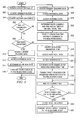
- the method begins at block 200, where navigation controller 30 receives a request from a particular user of device 14 identifying a travel itinerary 71.
- the itinerary 71 may identify travel from an origination point 86 to a plurality of destination points 88, or the itinerary may identify travel from an origination point 86 to one or more destination points 88 and returning to origination point 86.
- navigation guide 50 determines origination point 86 corresponding to the requesting device 14 using GPS information received from the requesting device 14 or a desired origination point 86 as input by the user via input device 22.
- navigation guide 50 identifies the requested or desired destination points 88.
- route calculator 52 determines available navigation routes corresponding to the request. For example, as described above, route calculator 52 may access geographic data 70 corresponding to the current location of the requesting device 14 and/or an origination point 86 specified by the request. Route calculator 52 may also access geographic data 70 to determine available navigation routes between destination points 88 and between origination point 86 and each destination point 88.
- navigation guide 50 obtains tracking data 72 for other GPS-enabled devices 14 traveling along the identified available navigation routes using GPS information acquired from each of the other devices 14. For example, as described above, using GPS information acquired for each device 14, position data 80 and velocity data 82 may be determined and correlated to each available navigation route.
- navigation comparator 58 determines flow rate data 84 for each of the available navigation routes. For example, as described above, navigation comparator 58 may access velocity data 82 for devices 14 and correlate each device 14 to a particular available navigation route such that a travel flow rate may be determined for each available navigation route.
- navigation comparator 58 compares or analyzes the available navigation routes using flow rate data 84.
- navigation comparator 58 accesses historical data 77 to determine historical traffic and/or flow rate patterns for the available navigation routes determined at block 206.
- navigation comparator 58 accesses schedule data 78 to determined scheduled events corresponding to available navigation routes to predict adverse traffic conditions associated with any of the available navigation routes.
- navigation comparator 58 determines a time-optimized navigation route segment sequence and associated travel directions for each route segment 85 of the itinerary 71.
- navigation controller 30 communicates the time-optimized navigation route segment sequence and travel directions for each route segment 85 to the requesting device 14.
- navigation controller 30 continues to monitor tracking data 72 during navigation route travel by the requesting device 14.
- FIGURE 3 is a flow chart illustrating another embodiment of a navigation routing method in accordance with the present invention.
- the method begins at block 300, where navigation guide 50 receives a navigation request from a user for navigation information for a desired travel itinerary via one of devices 14.
- navigation guide 50 identifies an origination point 86 for the travel itinerary.
- navigation guide 50 identifies the desired or selected destination points 88 for the travel itinerary.
- navigation guide 50 accesses historical data 77 corresponding to the available navigation routes for the desired travel itinerary 71.
- navigation guide 50 determines a time-optimized route segment sequence for the desired travel itinerary 71.
- the navigation guide 50 transmits the time-optimized route segment sequence to the requesting device 14.
- navigation guide 50 identifies a requested origination time for the travel itinerary 71. For example, the user may have the option of inputting or selecting a desired origination time for beginning travel of the travel itinerary 71.
- navigation guide 50 accesses historical data 77 corresponding to the requested origination time.
- navigation guide 50 accesses schedule data 78 corresponding to the desired origination time.
- navigation guide 50 determines a time-optimized route segment sequence for the travel itinerary 71 for the requested origination time.
- navigation guide 50 transmits the time-optimized route segment sequence for the travel itinerary 71 corresponding to the requested origination time to the requesting device 14. The method then proceeds to block 334.
- navigation guide 50 accesses tracking data 72 corresponding to current traffic conditions for the travel itinerary 71.
- navigation guide 50 accesses historical data 77 for the desired travel itinerary 71.
- navigation guide 50 accesses schedule data 78 to identify any scheduled conditions that may adversely affect traffic or travel conditions associated with the travel itinerary 71.
- navigation guide 50 determines a time-optimized route segment sequence and origination time for the desired travel itinerary 71.
- navigation guide 50 may be configured to compare present traffic conditions as indicated or reflected by tracking data 72 with predicted traffic flow conditions based on historical data 77 and/or schedule data 78 to identify a time-optimized route segment sequence and corresponding origination time for the desired travel itinerary 71.
- navigation guide 50 transmits the time-optimized route segment sequence and origination time for the desired travel itinerary 71 to the requesting device 14.
- navigation guide 50 monitors the current time to provide updates to the determined time-optimized route-segment sequence and/or origination time.
- decisional block 336 a determination is made whether the current time is within a predetermined time period or range relative to an origination time for the travel itinerary 71. If the current time is not within a predetermined time range relative to the origination time, the method returns to block 334. If the current time is within a predetermined time range relative to the origination time for the travel itinerary 71, the method proceeds from decisional block 336 to block 338, where navigation guide 50 updates the time-optimized route segment sequence for the travel itinerary 71.
- navigation guide 50 may access tracking data 72, historical data 77, and/or scheduled data 78 to determine and update the time-optimized route segment sequence for the travel itinerary 71.
- navigation guide 50 transmits the updated time-optimized route segment sequence to the requesting device 14.
- embodiments of the present invention provide a time-optimized navigation route segment sequence for a desired travel itinerary 71 and time-optimized travel directions for each route segment 85 of the itinerary 71.
- the route segment sequence and associated travel directions are determined by analyzing traffic flow rates and patterns via GPS-enabled devices 14 traveling along various navigation routes, evaluating historical traffic conditions along various navigation routes corresponding to a desired itinerary 71, and/or evaluating scheduled conditions affecting a particular travel itinerary 71.
- the traffic patterns and flow rates may be monitored during travel over a particular itinerary 71 such that real-time updates to the navigation route segment sequence or route segment 85 travel directions may be provided to a user.
- Embodiments of the present invention may also be configured to provide a time-optimized origination time for a desired travel itinerary and/or provide time-optimized travel instructions for a user-specified origination time. Additionally, it should be understood that in the methods described in FIGURES 2 and 3, certain functions may be omitted, combined, or accomplished in a sequence different than depicted in FIGURES 2 and 3. Also, it should be understood that the methods depicted in FIGURES 2 and 3 may be altered to encompass any of the other features or aspects described elsewhere in the specification.
Abstract
A navigation routing system (10) comprises a navigation guide (50) adapted to
receive a travel itinerary (71) from a requesting device (14). The travel itinerary (71)
comprises at least two route segments (85). The navigation guide (50) is also adapted to
automatically determine a time-optimized route segment sequence for the travel itinerary
(71).
Description
- The present invention relates generally to the field of navigation systems and, more particularly, to a navigation routing system and method.
- Several types of systems or methods for providing traffic and/or routing information to motorists exist. For example, most motorists are familiar with radio broadcasts that provide traffic information during peak traffic periods throughout the day. These radio broadcasts generally use aerial observation techniques or remote camera monitoring to obtain the traffic-related information. However, the traffic-related information is only periodically broadcast to listeners--for example, every ten or fifteen minutes--such that a motorist may encounter adverse traffic conditions before hearing a broadcast of the traffic conditions. Additionally, even after hearing about adverse traffic conditions, the motorist may not be familiar with alternate routes for avoiding the adverse traffic condition.
- Various types of navigation systems may also be used by motorists to plan a route from a current location to a selected destination. For example, vehicles may be equipped with a global positioning system (GPS) receiver which may be used to determine routing information from the motorist's current location to the selected destination. Briefly, a global positioning system generally includes multiple orbiting satellites that transmit radio signals of a known format. A GPS receiver located on or near the earth's surface receives the signals from multiple GPS satellites (i.e., three geosynchronous satellites orbiting the earth) and computes the position of the receiver in three-dimensional space. Thus, vehicles equipped with a GPS receiver may input a selected destination to an onboard computer system to automatically determine routing information from a current location to a selected destination. GPS navigation systems do not accommodate multiple-stop or multiple-segment route determination.
- In accordance with one embodiment of the present invention, a navigation routing system comprises a navigation guide adapted to receive a travel itinerary from a requesting device. The travel itinerary comprises at least two route segments. The navigation guide is also adapted to automatically determine a time-optimized route segment sequence for the travel itinerary.
- In accordance with another embodiment of the present invention, a navigation routing method comprises receiving a navigation request for a travel itinerary from a requesting device where the travel itinerary comprises at least two route segments. The method also comprises automatically determining a time-optimized route segment sequence for the travel itinerary.
- In accordance with yet another embodiment of the present invention, a navigation routing system comprises a navigation guide adapted to receive a travel itinerary request from a user. The navigation guide is adapted to automatically determine a time-optimized origination time for the travel itinerary.
- For a more complete understanding of the present invention and the advantages thereof, reference is now made to the following descriptions taken in connection with the accompanying drawings in which:
- FIGURE 1 is a diagram illustrating an embodiment of a navigation routing system in accordance with the present invention;
- FIGURE 2 is a flow chart illustrating an embodiment of a navigation routing method in accordance with the present invention; and
- FIGURE 3 is a flow chart illustrating another embodiment of a navigation routing method in accordance with the present invention.
- The preferred embodiments of the present invention and the advantages thereof are best understood by referring to FIGURES 1-3 of the drawings, like numerals being used for like and corresponding parts of the various drawings.
- FIGURE 1 is a diagram illustrating an embodiment of a
navigation routing system 10 in accordance with the present invention. Briefly,system 10 enables a user to input or select a plurality of desired travel stops or destinations for a particular travel itinerary.System 10 provides travel or navigation instructions to the user to enable the user to travel to the corresponding desired destinations. For example, in some embodiments, portable or mobile global positioning system (GPS)-enabled devices are used to analyze movement or flow rates of traffic for various routes associated with the desired travel destinations such that a time-optimized navigation route segment sequence for each leg or segment of the itinerary may be determined for traveling to each of the desired destinations. In some embodiments, historical traffic and/or flow patterns may be evaluated to determine a time-optimized navigation route segment sequence for each segment of the travel itinerary. For example, in one embodiment, a user of a portable or mobile GPS-enabled electronic device, such as a portable phone or other device, may request travel directions and/or a navigation route segment sequence from a current location to a desired quantity of selected or identified destinations. The desired destinations may be associated with destinations for product delivery, tour destinations, shopping or errand destinations, or any other points of interest. Based on GPS tracking information obtained from other GPS-enabled devices along various available navigation routes to the desired destinations, evaluating historical traffic flow patterns for various navigation routes corresponding to the desired destinations, and/or evaluating scheduled conditions affecting travel, a time-optimized navigation route segment sequence through the desired destinations may be provided for the request. Additionally, a time-optimized origination time for beginning travel of the travel itinerary may also be provided. Thus,system 10 automatically determines a time-optimized order in which the destinations should be visited and determines a time-optimized navigation route to each of the destinations by evaluating various conditions affecting, or that may affect, travel along a desired travel itinerary. - In the embodiment illustrated in FIGURE 1,
system 10 comprises a satellite network orsystem 12 for transmitting global positioning signals to GPS-enabled units ordevices 14.Devices 14 may comprise a portable telephone, laptop computer, pager, personal digital assistant, or any other type of portable or mobile unit or device having aGPS receiver 16 for receiving the global positioning signals fromsatellite system 12. As used herein, the term "portable" relates to any movable object such that global positioning information may be acquired relating to movement ofGPS receiver 16 of such object. Thus, it should be understood thatdevice 14 may comprise a motorized object (e.g., a car, truck, motorcycle, motorized scooter, etc.), a non-motorized object (e.g., a bicycle, inline skates, skateboard, etc.), or any other type of movable object equipped with aGPS receiver 16. In the embodiment illustrated in FIGURE 1, eachdevice 14 may also comprise auser interface 20 for communicating information to and fromdevice 14. For example, eachuser interface 20 may comprise aninput device 22 and anoutput device 24.Input device 22 may comprise any device or object for enabling information to be input intodevice 14 including, but not limited to, a keypad, touch-based liquid crystal display screen, or microphone.Output device 24 may comprise any type of device or object for receiving the output of information fromdevice 14 including, but not limited to, any device for providing audible and/or visual information to a user ofdevice 14. However, it should be understood thatdevice 14 may also comprise onlyreceiver 16 to accommodate tracking ofdevice 14 without accommodating input and/or output functionality viainput device 22 oroutput device 24, respectively. - In FIGURE 1,
system 10 also comprises anavigation controller 30 for receiving global positioning system information fromdevices 14 and providing to a requestingdevice 14 navigation instructions corresponding to requested or desired destinations. As illustrated in FIGURE 1, eachdevice 14 is communicatively linked tonavigation controller 30 via awireless communication network 32 to accommodate information transfer betweendevices 14 andnavigation controller 30. In the embodiment illustrated in FIGURE 1,navigation controller 30 comprises aprocessor 40, aninterface 42, and amemory 44.Interface 42 provides a platform for the communication of information betweendevices 14 andnavigation controller 30. For example, in operation, a user ofdevice 14 may useinput device 22 to input or select a desired travel itinerary comprising a plurality of destinations or travel stops. The request is transmitted viacommunication network 32 tonavigation controller 30. Additionally, GPS information corresponding to the requestingdevice 14 andother devices 14 is received bynavigation controller 30 viacommunication networks 32. After determining a time-optimized navigation route segment sequence for the desired destinations and/or determining time-optimized navigation routes between the desired destinations, the determined navigation route segment sequence and navigation travel instructions are transmitted to the requestingdevice 14 viacommunication network 32. - In the embodiment illustrated in FIGURE 1,
navigation controller 30 comprises anavigation guide 50 executable byprocessor 40.Navigation guide 50 may comprise software, hardware, or a combination of software and hardware. In FIGURE 1,navigation guide 50 is illustrated as being stored inmemory 44 so as to be executable byprocessor 40; however, it should be understood thatnavigation guide 50 may be otherwise stored, even remotely, so as to be accessible and executable byprocessor 40. In the embodiment illustrated in FIGURE 1,navigation guide 50 comprises aroute calculator 52, adistance calculator 54, atime calculator 56, and anavigation comparator 58.Route calculator 52,distance calculator 54,time calculator 56, andnavigation comparator 58 may comprise software, hardware, or a combination of software and hardware. Briefly,route calculator 52 identifies various available routes corresponding to the destinations designated by the user of one ofdevices 14 from a current location of the requestingdevice 14 to each of the designated destinations and available navigation routes between the designated destinations.Distance calculator 54 determines a travel distance corresponding to each available route identified byroute calculator 52.Time calculator 56 determines a travel time for each available route identified byroute calculator 52 using GPS-based tracking information fordevices 14 traveling along the identified available routes.Navigation comparator 58 compares the available navigation routes and corresponding travel time information and selects a time-optimized navigation route segment sequence and associated navigation travel instructions for the request. - As illustrated in FIGURE 1,
navigation controller 30 also comprises adatabase 60 stored inmemory 44. In the embodiment illustrated in FIGURE 1,database 60 comprisesgeographic data 70,itinerary data 71, trackingdata 72,navigation route data 74,navigation request data 76,historical data 77,schedule data 78, andinventory data 90.Geographic data 70 comprises information associated with the geographic characteristics of a particular region corresponding to the locations ofdevices 14. For example,geographic data 70 may comprise information associated with street locations, street intersections, building or point-of-interest locations, traffic signal location information, and any other type of information corresponding to a particular geographic region corresponding to a location ofdevices 14.Geographic data 70 may be partitioned into various regions based on a regional location of a requestingdevice 14. Thus, in response to a navigation request by a user, corresponding regionalgeographic data 70 is acquired or accessed for determining the time-optimized navigation route segment sequence and navigation travel instructions for the user. -
Itinerary data 71 comprises information associated with a desired travel itinerary such as various travel destinations or locations designated or selected by the user. For example,itinerary data 71 may comprise a listing of destinations associated with product deliveries, tour destinations, shopping destinations, or other points of interest. In the illustrated embodiment,itinerary data 71 comprisesroute segment data 85 having information associated with each leg or segment of a desiredtravel itinerary 71. In the embodiment illustrated in FIGURE 1,route segment data 85 comprisesorigination point data 86 anddestination point data 88.Origination point data 86 comprises information associated with a current location ofdevice 14 or a desired originating point of travel.Destination point data 88 comprises information associated with designated or selected travel destinations. Thus, the desiredtravel itinerary 71 may begin atorigination point 86 and include a plurality of destination points 88 or, alternatively, the desiredtravel itinerary 71 may begin atorigination point 86, include at least onedestination point 88, and return toorigination point 86. Thus, eachroute segment 85 oftravel itinerary 71 may comprise travel between twodestination points 88 or between adestination point 88 and anorigination point 86. Thus, in some embodiments, an interface associated withinput device 22 may be configured to receive a plurality ofpoints points points navigation controller 30 as a desireditinerary 71. -
Tracking data 72 comprises information associated with the location and movement of aparticular device 14. For example, in the embodiment illustrated in FIGURE 1, trackingdata 72 comprisesposition data 80,velocity data 82, and flowrate data 84.Position data 80 comprises information associated with a current position of aparticular device 14 based on GPS information received from thatdevice 14.Velocity data 82 comprises information associated with a traveling velocity of aparticular device 14 based on multiple position locations of theparticular device 14 measured over time.Flow rate data 84 comprises information associated with traffic flow for a particular navigation route based onvelocity data 82 for each of a plurality ofdevices 14 traveling along a particular navigation route. -
Navigation route data 74 comprises information associated with each available navigation route identified byroute calculator 52 in response to a request by aparticular device 14.Navigation route data 74 may also comprise information associated with a time-optimized navigation route segment sequence for thetravel itinerary 71 determined bynavigation guide 50.Navigation route data 74 may also comprise time-optimized travel information for eachroute segment 85 of thetravel itinerary 71.Navigation request data 76 comprises information associated with theparticular travel itinerary 71 input or selected by aparticular device 14. For example,navigation request data 76 may comprise information associated with a current position ofdevice 14,origination point 86 of travel, and/or requested or desired destination points 88 for theparticular device 14 travel. -
Historical data 77 comprises information associated with historical flow rates and/or traffic patterns for various navigation routes such thatnavigation guide 50 may predict flow rates and/or traffic patterns for various routes corresponding to the request. For example,navigation guide 50 may forecast or predict traffic flow rates and patterns for various navigation routes between destination points 88 and/or betweenorigination point 86 and eachdestination point 88 for various time periods throughout the day to determine an optimal time-based route segment sequence for travel to the desired destination points 88. Thus, for example, even though a particular navigation route to or between particular destination points 88 may be the furthest distance (among all destination points 88 identified or selected by the user) fromorigination point 86, historical flow rate and/or traffic patterns may indicate that theparticular destination point 88 should be visited early in the route segment sequence to avoid adverse traffic patterns and flow rates at a later time. Correspondingly,historical data 77 may also indicate that traffic patterns and flow rates for particular navigation routes are less adverse at particular time periods throughout the day, thereby enablingnavigation guide 50 to select a particular time period in the navigation route segment sequence for placing certain destination points 88. -
Schedule data 78 comprises information associated with known or scheduled travel conditions affecting traffic flow rates or patterns for the various available navigation routes. For example,schedule data 78 may comprise information associated with scheduled road construction or lane closures along the available navigation routes. -
Inventory data 90 comprises information associated withactive devices 92. As used herein, the term "active" relates todevices 14 currently in use by a user such as any device being in a power "on" mode or other state capable of acting on a request made by a user. For example, in one embodiment,navigation guide 50 may select a time-optimized navigation route segment sequence based on trackingdata 72 corresponding only toactive devices 92. In this embodiment,system 10 is configured to determine the time-optimized navigation route segment sequence based on the presumption thatinactive devices 14 are not currently in transit along available navigation routes, thereby reducing the quantity ofdevices 14 that are tracked to determine the time-optimized navigation route. Preferably,system 10 is configured such that GPS information may be acquired for anydevice 14, whether active or inactive, such that GPS information may be readily acquired bynavigation controller 30 from anydevice 14 of interest along a particular navigation route in order to select a time-optimized navigation route segment sequence for the request. - In operation,
navigation controller 30 receives a request from aparticular device 14 designating or selecting aparticular travel itinerary 71. In response to the request,navigation controller 30 may request or automatically receive GPS information from the requestingdevice 14 or, in some embodiments, GPS information may be automatically transmitted bydevice 14 in connection with the travel request. Additionally,system 10 may also be configured to automatically monitor and acquire GPS information corresponding to each GPS-enableddevice 14 within a particular operating region. The GPS information corresponding to the requestingdevice 14 andother devices 14 in a particular operating region may be stored as trackingdata 72 indatabase 60. From trackingdata 72,navigation guide 50 may determineposition data 80 corresponding to the requestingdevice 14. Additionally, information associated with the travel request received from aparticular device 14 may be stored asnavigation request data 76 indatabase 60. - Based on
navigation request data 76,route calculator 52 accessesgeographic data 70 andposition data 80 to determine information corresponding to a current location ofdevice 14 or, alternatively, anorigination point 86 for travel, and the desired or designated destination points 88. Additionally,route calculator 52 usesgeographic data 70 to identify available navigation routes from theorigination point 86 to the desired destination point(s) 88, available navigation routes between destination points 88, and, in some circumstances, available navigation routes from destination point(s) 88 returning toorigination point 86. The available navigation routes corresponding to the request may be stored asnavigation route data 74 indatabase 60. -
Navigation controller 30 also obtains GPS information associated withother devices 14 in the operating region of the available navigation routes and stores the GPS information as trackingdata 72. Using trackingdata 72,position data 80 may be determined for eachdevice 14 within the operating region. Additionally, monitoring ofposition data 80 for eachdevice 14 over time may be used to determinevelocity data 82 corresponding to eachdevice 14. - Using tracking
data 72 andgeographic data 70,navigation guide 50 determinesflow rate data 84 for each available navigation route identified byroute calculator 52. For example,navigation comparator 58 may accessposition data 80 for eachdevice 14 to locate eachdevice 14 corresponding togeographic data 70 for the operating region.Navigation comparator 58 identifiesparticular devices 14 traveling along available navigation routes identified byroute calculator 52. For thedevices 14 associated with a particular available navigation route,navigation comparator 58 may accessvelocity data 82 to determineflow rate data 84 for each available navigation route.Navigation comparator 58 may also accessgeographic data 70 to identify traffic signal locations and other geographic information to correlate movement ofparticular devices 14 along available navigation routes.Navigation comparator 58 may also acquire information associated with traffic flow rates and patterns from other sources via wired or wireless networks such as, but not limited to, autonomous devices, including traffic monitoring cameras and other types of microelectromechanical system devices, and reporting information from broadcast sources. -
Route calculator 52 andnavigation comparator 58 may also dynamically cooperate with each other to automatically determine time-optimized navigation routes betweenorigination point 86 and destination point(s) 88 and/or between destination points 88. For example, various types of navigation-solving algorithms may be used to evaluate route patterns from a diverse set of navigation starting points. In some embodiments,route calculator 52 may accessgeographic data 70 to identify a most direct navigation route fromorigination point 86 to one of destination points 88 or a most direct navigation route between two destination points 88. For the identified most direct navigation route,navigation comparator 58 determinesflow rate data 84. From the most direct navigation route,route calculator 52 may make a series of "indirect turns" away from the most direct route and recompute or revise the navigation route from each "indirect turn." For each recomputed navigation route based on an "indirect turn,"navigation comparator 58 recalculates flowrate data 84. This "indirect turn" process may be reiterated until a time-optimized navigation route is determined or until travel time for the navigation route exceeds a particular threshold, such as double the time computed for the most direct route or double the shortest computed travel time for any identified navigation route. However, it should be understood that other methods may be used to dynamically determine time-optimized navigation routes. - Using
flow rate data 84 determined for each available navigation route,navigation comparator 58 compares travel times corresponding to each available navigation route. For example,distance calculator 54 may be used to determine the travel distance for each available navigation route. Usingflow rate data 84,time calculator 56 may determine a travel time corresponding to the identified distance for each available navigation route.Navigation comparator 58 analyzes the travel times associated with each available navigation route and automatically determines time-optimized routing for eachroute segment 85 of the requestedtravel itinerary 71.Navigation comparator 58 also identifies a time-optimized navigation route segment sequence to transmit to the requestingdevice 14 for the requestedtravel itinerary 71. The time-optimized navigation route segment sequence and associated travel routes may also be stored asnavigation route data 74. Further,navigation comparator 58 may accesshistorical data 77 corresponding to the navigation routes identified byroute calculator 52 to determine whether route segment sequence modifications may be advantageous based on historical traffic and flow rate patterns for the various navigation routes. For example,historical data 77 may indicate that particular navigation routes corresponding to the request may become adverse at particular times of the day. Thus,navigation comparator 58 may modify or select a navigation route segment sequence to avoid historically-based adverse traffic conditions.Navigation comparator 58 may also accessschedule data 78 to identify scheduled travel conditions affecting any of the available navigation routes to predict travel conditions for the associated navigation routes and select or modify the determined navigation route segment sequence based onschedule data 78. -
Historical data 77 may also comprise information associated with "recent" traffic trends or patterns. For example, in some embodiments, onlyactive devices 92 may be monitored such that GPS information foractive devices 92 is used to generate trackingdata 72. Navigation guide may monitorhistorical data 77 and/orinventory data 90 to determine whether a sudden increase in a quantity ofactive devices 92 indicates an adverse traffic condition based on, for example, an increase in call volume fromtelephone devices 14 located in particular geographic region. -
Navigation controller 30 may also be configured to continually monitor the requestingdevice 14 travel over the identified navigation routes and automatically provide updates to the navigation travel based on changes to trackingdata 72 or any other condition associated with thetravel itinerary 71 that may adversely affect travel. For example,navigation controller 30 may continue to monitor trackingdata 72 fordevices 14 traveling along each available navigation route corresponding to the request and, asadverse tracking data 72 conditions arise, update the time-optimized navigation route segment sequence and/or particular navigation route travel directions for aparticular route segment 85 provided to the requestingdevice 14. Thus, asflow rate data 84 changes for a particular navigation route due to adverse travel or traffic conditions,navigation controller 30 may automatically update or change the navigation route betweenparticular points 86 and/or 88 and update or change the route segment sequence for the requested travel itinerary and transmit a new time-optimized navigation route segment sequence and travel instructions to the requestingdevice 14. -
System 10 may also be configured to provide an optimum time period for beginning and/or completing the desiredtravel itinerary 71. For example, the user may have the option of requesting an immediate departure or specifying a particular time of day for beginning thetravel itinerary 71. If the user selects an immediate departure,navigation guide 50 evaluates present and predicted traffic conditions via trackingdata 72 andhistorical data 77 and determines navigation routing instructions and a navigation route segment sequence for the request. If the user selects a future time period for beginning travel,navigation guide 50 may be configured to determine navigation instructions and a navigation route segment sequence based onhistorical data 77 to predict traffic conditions for the specified time period and update the navigation instructions and route segment sequence using trackingdata 72 as the designated time period approaches. The user may also have the option of requestingnavigation guide 50 to identify an optimum origination time for beginning travel for theitinerary 71. Based onhistorical data 77 and/or trackingdata 72,navigation guide 50 may determine a particular time of day for originating or completing thetravel itinerary 71 such that travel time is minimized. For example, present traffic conditions as determined from trackingdata 72 and/or predicted traffic conditions as determined fromhistorical data 77 may indicate that travel time may be reduced if travel originates at a particular time. Thus,navigation guide 50 may be configured to automatically predict an optimum time for departure for the desiredtravel itinerary 71 and an optimum navigation route segment sequence and navigation instructions for eachroute segment 85 for the desiredtravel itinerary 71. - FIGURE 2 is a flow chart illustrating an embodiment of a navigation routing method in accordance with the present invention. The method begins at
block 200, wherenavigation controller 30 receives a request from a particular user ofdevice 14 identifying atravel itinerary 71. As described above, theitinerary 71 may identify travel from anorigination point 86 to a plurality of destination points 88, or the itinerary may identify travel from anorigination point 86 to one or more destination points 88 and returning toorigination point 86. Atblock 202,navigation guide 50 determinesorigination point 86 corresponding to the requestingdevice 14 using GPS information received from the requestingdevice 14 or a desiredorigination point 86 as input by the user viainput device 22. Atblock 204,navigation guide 50 identifies the requested or desired destination points 88. - At
block 206,route calculator 52 determines available navigation routes corresponding to the request. For example, as described above,route calculator 52 may accessgeographic data 70 corresponding to the current location of the requestingdevice 14 and/or anorigination point 86 specified by the request.Route calculator 52 may also accessgeographic data 70 to determine available navigation routes between destination points 88 and betweenorigination point 86 and eachdestination point 88. Atblock 208,navigation guide 50 obtains trackingdata 72 for other GPS-enableddevices 14 traveling along the identified available navigation routes using GPS information acquired from each of theother devices 14. For example, as described above, using GPS information acquired for eachdevice 14,position data 80 andvelocity data 82 may be determined and correlated to each available navigation route. - At
block 216,navigation comparator 58 determinesflow rate data 84 for each of the available navigation routes. For example, as described above,navigation comparator 58 may accessvelocity data 82 fordevices 14 and correlate eachdevice 14 to a particular available navigation route such that a travel flow rate may be determined for each available navigation route. - At
block 218,navigation comparator 58 compares or analyzes the available navigation routes usingflow rate data 84. Atblock 219,navigation comparator 58 accesseshistorical data 77 to determine historical traffic and/or flow rate patterns for the available navigation routes determined atblock 206. Atblock 220,navigation comparator 58accesses schedule data 78 to determined scheduled events corresponding to available navigation routes to predict adverse traffic conditions associated with any of the available navigation routes. Atblock 221,navigation comparator 58 determines a time-optimized navigation route segment sequence and associated travel directions for eachroute segment 85 of theitinerary 71. Atblock 222,navigation controller 30 communicates the time-optimized navigation route segment sequence and travel directions for eachroute segment 85 to the requestingdevice 14. - At
block 224,navigation controller 30 continues to monitor trackingdata 72 during navigation route travel by the requestingdevice 14. Atblock 226, a determination is made whether trackingdata 72 changes exceed a predetermined threshold such that a different navigation route segment sequence orroute segment 85 directions may be optimal for the request. If changes to trackingdata 72 exceed the predetermined threshold, the method returns to block 216, where navigation guide 50 may automatically re-compute and identify an alternative time-optimized navigation route segment sequence and/orroute segment 85 travel directions. If trackingdata 72 changes have not exceeded a predetermined threshold, the method proceeds fromblock 226 todecisional block 228, where a determination is made whether travel for theitinerary 71 is complete. If travel for theitinerary 71 is not complete, the method returns to block 224, wherenavigation controller 30 continues monitoring trackingdata 72. - FIGURE 3 is a flow chart illustrating another embodiment of a navigation routing method in accordance with the present invention. The method begins at
block 300, where navigation guide 50 receives a navigation request from a user for navigation information for a desired travel itinerary via one ofdevices 14. Atblock 302,navigation guide 50 identifies anorigination point 86 for the travel itinerary. Atblock 304,navigation guide 50 identifies the desired or selected destination points 88 for the travel itinerary. - At
decisional block 306, a determination is made whether the user of requestingdevice 14 identified an origination time for beginning the desired travel itinerary. For example, the user may be prompted or have the option of selecting or indicating an immediate departure for the travel itinerary or selecting a desired origination time for beginning the travel itinerary. If the user of the requestingdevice 14 has identified a desired origination time, the method proceeds fromdecisional block 306 todecisional block 308, where a determination is made whether the desired origination time corresponds to an immediate departure for the travel itinerary. If an immediate departure for the travel itinerary is desired, the method proceeds fromdecisional block 308 to block 310, where navigation guide 50accesses tracking data 72 for current traffic flow conditions corresponding to available navigation routes for thetravel itinerary 71. Atblock 312,navigation guide 50 accesseshistorical data 77 corresponding to the available navigation routes for the desiredtravel itinerary 71. Atblock 314,navigation guide 50 determines a time-optimized route segment sequence for the desiredtravel itinerary 71. Atblock 316, thenavigation guide 50 transmits the time-optimized route segment sequence to the requestingdevice 14. - If an immediate departure for the travel itinerary is not desired or designated, the method proceeds from
decisional block 308 to block 318, where navigation guide 50 identifies a requested origination time for thetravel itinerary 71. For example, the user may have the option of inputting or selecting a desired origination time for beginning travel of thetravel itinerary 71. Atblock 320,navigation guide 50 accesseshistorical data 77 corresponding to the requested origination time. Atblock 321,navigation guide 50accesses schedule data 78 corresponding to the desired origination time. Atblock 322,navigation guide 50 determines a time-optimized route segment sequence for thetravel itinerary 71 for the requested origination time. Atblock 324,navigation guide 50 transmits the time-optimized route segment sequence for thetravel itinerary 71 corresponding to the requested origination time to the requestingdevice 14. The method then proceeds to block 334. - If the user of the requesting
device 14 did not specify or select a particular origination time for beginning thetravel itinerary 71 atdecisional block 306, the method proceeds fromdecisional block 306 to block 326, where navigation guide 50accesses tracking data 72 corresponding to current traffic conditions for thetravel itinerary 71. Atblock 328,navigation guide 50 accesseshistorical data 77 for the desiredtravel itinerary 71. Atblock 329,navigation guide 50accesses schedule data 78 to identify any scheduled conditions that may adversely affect traffic or travel conditions associated with thetravel itinerary 71. Atblock 330,navigation guide 50 determines a time-optimized route segment sequence and origination time for the desiredtravel itinerary 71. For example,navigation guide 50 may be configured to compare present traffic conditions as indicated or reflected by trackingdata 72 with predicted traffic flow conditions based onhistorical data 77 and/orschedule data 78 to identify a time-optimized route segment sequence and corresponding origination time for the desiredtravel itinerary 71. Atblock 332,navigation guide 50 transmits the time-optimized route segment sequence and origination time for the desiredtravel itinerary 71 to the requestingdevice 14. - At
block 334,navigation guide 50 monitors the current time to provide updates to the determined time-optimized route-segment sequence and/or origination time. Atdecisional block 336, a determination is made whether the current time is within a predetermined time period or range relative to an origination time for thetravel itinerary 71. If the current time is not within a predetermined time range relative to the origination time, the method returns to block 334. If the current time is within a predetermined time range relative to the origination time for thetravel itinerary 71, the method proceeds fromdecisional block 336 to block 338, where navigation guide 50 updates the time-optimized route segment sequence for thetravel itinerary 71. For example, as described above,navigation guide 50 may access trackingdata 72,historical data 77, and/or scheduleddata 78 to determine and update the time-optimized route segment sequence for thetravel itinerary 71. Atblock 340,navigation guide 50 transmits the updated time-optimized route segment sequence to the requestingdevice 14. - Thus, embodiments of the present invention provide a time-optimized navigation route segment sequence for a desired
travel itinerary 71 and time-optimized travel directions for eachroute segment 85 of theitinerary 71. The route segment sequence and associated travel directions are determined by analyzing traffic flow rates and patterns via GPS-enableddevices 14 traveling along various navigation routes, evaluating historical traffic conditions along various navigation routes corresponding to a desireditinerary 71, and/or evaluating scheduled conditions affecting aparticular travel itinerary 71. The traffic patterns and flow rates may be monitored during travel over aparticular itinerary 71 such that real-time updates to the navigation route segment sequence orroute segment 85 travel directions may be provided to a user. Embodiments of the present invention may also be configured to provide a time-optimized origination time for a desired travel itinerary and/or provide time-optimized travel instructions for a user-specified origination time. Additionally, it should be understood that in the methods described in FIGURES 2 and 3, certain functions may be omitted, combined, or accomplished in a sequence different than depicted in FIGURES 2 and 3. Also, it should be understood that the methods depicted in FIGURES 2 and 3 may be altered to encompass any of the other features or aspects described elsewhere in the specification.
Claims (10)
- A navigation routing system (10), comprising:a navigation guide (50) adapted to receive a travel itinerary (71) from a requesting device (14), the travel itinerary (71) having at least two route segments (85), the navigation guide (50) adapted to automatically determine a time-optimized route segment sequence for the travel itinerary (71).
- The system (10) of Claim 1, wherein the navigation guide (50) determines a time-optimized navigation route for at least one of the route segments (85).
- The system (10) of Claim 1, wherein the navigation guide (50) determines the time-optimized route segment sequence using tracking data (72) associated with at least one global positioning system (GPS)-enabled device (14) located along at least one route (85) of the travel itinerary (71).
- The system (10) of Claim 1, wherein the navigation guide (50) determines the time-optimized route segment sequence using historical data (77) associated with the travel itinerary (71).
- The system (10) of Claim 1, wherein the navigation guide (50) is adapted to determine a time-optimized origination time for the travel itinerary (71).
- The system (10) of Claim 1, wherein the navigation guide (50) is adapted to receive a user-desired origination time for the travel itinerary (71).
- The system (10) of Claim 1, wherein the navigation guide (50) is adapted to obtain inventory data (90) corresponding to active GPS-enabled mobile devices (14) located along at least one route of the travel itinerary (71).
- The system (10) of Claim 1, wherein the navigation guide (50) determines the time-optimized route segment sequence using schedule data (78) associated with at least one route of the travel itinerary (71).
- The system (10) of Claim 1, wherein the requesting device (14) comprises at least one of a telephone, a personal digital assistant, a pager, and a portable computer.
- The system (10) of Claim 1, wherein the navigation guide (50) is adapted to update the route segment sequence when an origination time for the travel itinerary (71) falls within a predetermined time range.
Priority Applications (1)
| Application Number | Priority Date | Filing Date | Title |
|---|---|---|---|
| EP05012793A EP1571419A3 (en) | 2003-11-03 | 2004-05-19 | Navigation routing system and method |
Applications Claiming Priority (2)
| Application Number | Priority Date | Filing Date | Title |
|---|---|---|---|
| US700243 | 2003-11-03 | ||
| US10/700,243 US20050096840A1 (en) | 2003-11-03 | 2003-11-03 | Navigation routing system and method |
Related Child Applications (1)
| Application Number | Title | Priority Date | Filing Date |
|---|---|---|---|
| EP05012793A Division EP1571419A3 (en) | 2003-11-03 | 2004-05-19 | Navigation routing system and method |
Publications (1)
| Publication Number | Publication Date |
|---|---|
| EP1528361A1 true EP1528361A1 (en) | 2005-05-04 |
Family
ID=34423466
Family Applications (2)
| Application Number | Title | Priority Date | Filing Date |
|---|---|---|---|
| EP04011922A Withdrawn EP1528361A1 (en) | 2003-11-03 | 2004-05-19 | Navigation routing system and method |
| EP05012793A Withdrawn EP1571419A3 (en) | 2003-11-03 | 2004-05-19 | Navigation routing system and method |
Family Applications After (1)
| Application Number | Title | Priority Date | Filing Date |
|---|---|---|---|
| EP05012793A Withdrawn EP1571419A3 (en) | 2003-11-03 | 2004-05-19 | Navigation routing system and method |
Country Status (2)
| Country | Link |
|---|---|
| US (1) | US20050096840A1 (en) |
| EP (2) | EP1528361A1 (en) |
Cited By (5)
| Publication number | Priority date | Publication date | Assignee | Title |
|---|---|---|---|---|
| EP1726917A1 (en) * | 2005-05-27 | 2006-11-29 | C.R.F. Società Consortile per Azioni | An off-board navigation system for vehicles |
| EP1726916A1 (en) * | 2005-05-27 | 2006-11-29 | C.R.F. Società Consortile per Azioni | An off-board navigation system for vehicles |
| EP1986171A1 (en) * | 2007-04-25 | 2008-10-29 | Aisin AW Co., Ltd. | Apparatus, method, and program for generating road information |
| US8068981B2 (en) | 2006-05-26 | 2011-11-29 | C.R.F. Societa Consortile Per Azioni | Off-board navigation system for vehicles |
| CN103218240A (en) * | 2013-04-18 | 2013-07-24 | 武汉光庭信息技术有限公司 | Abandoned road recognition method based on floating vehicle trajectories |
Families Citing this family (60)
| Publication number | Priority date | Publication date | Assignee | Title |
|---|---|---|---|---|
| US8452526B2 (en) * | 2003-12-15 | 2013-05-28 | Gary Ignatin | Estimation of roadway travel information based on historical travel data |
| US7522995B2 (en) | 2004-02-05 | 2009-04-21 | Nortrup Edward H | Method and system for providing travel time information |
| US7319931B2 (en) * | 2004-04-06 | 2008-01-15 | Honda Motor Co., Ltd. | Methods for filtering and providing traffic information |
| US7366606B2 (en) * | 2004-04-06 | 2008-04-29 | Honda Motor Co., Ltd. | Method for refining traffic flow data |
| US8453065B2 (en) | 2004-06-25 | 2013-05-28 | Apple Inc. | Preview and installation of user interface elements in a display environment |
| US7908080B2 (en) | 2004-12-31 | 2011-03-15 | Google Inc. | Transportation routing |
| US7353034B2 (en) | 2005-04-04 | 2008-04-01 | X One, Inc. | Location sharing and tracking using mobile phones or other wireless devices |
| US7698061B2 (en) | 2005-09-23 | 2010-04-13 | Scenera Technologies, Llc | System and method for selecting and presenting a route to a user |
| US7580792B1 (en) * | 2005-10-28 | 2009-08-25 | At&T Corp. | Method and apparatus for providing traffic information associated with map requests |
| ATE464902T1 (en) * | 2006-02-09 | 2010-05-15 | Teva Pharma | STABLE PHARMACEUTICAL PREPARATIONS OF MONTELUKAST SODIUM |
| US7702456B2 (en) * | 2006-04-14 | 2010-04-20 | Scenera Technologies, Llc | System and method for presenting a computed route |
| US7761350B1 (en) * | 2006-04-26 | 2010-07-20 | Aol Inc. | Biasing of search result clustering to ensure more effective point of interest (POI) targeting |
| US7812717B1 (en) | 2007-02-02 | 2010-10-12 | Resource Consortium Limited | Situational network |
| WO2008134595A1 (en) * | 2007-04-27 | 2008-11-06 | Pelago, Inc. | Determining locations of interest based on user visits |
| US7668653B2 (en) | 2007-05-31 | 2010-02-23 | Honda Motor Co., Ltd. | System and method for selectively filtering and providing event program information |
| US8108144B2 (en) | 2007-06-28 | 2012-01-31 | Apple Inc. | Location based tracking |
| US8275352B2 (en) | 2007-06-28 | 2012-09-25 | Apple Inc. | Location-based emergency information |
| US8311526B2 (en) | 2007-06-28 | 2012-11-13 | Apple Inc. | Location-based categorical information services |
| US8385946B2 (en) | 2007-06-28 | 2013-02-26 | Apple Inc. | Disfavored route progressions or locations |
| US8290513B2 (en) | 2007-06-28 | 2012-10-16 | Apple Inc. | Location-based services |
| US8180379B2 (en) | 2007-06-28 | 2012-05-15 | Apple Inc. | Synchronizing mobile and vehicle devices |
| US9066199B2 (en) | 2007-06-28 | 2015-06-23 | Apple Inc. | Location-aware mobile device |
| US9109904B2 (en) | 2007-06-28 | 2015-08-18 | Apple Inc. | Integration of map services and user applications in a mobile device |
| US8332402B2 (en) | 2007-06-28 | 2012-12-11 | Apple Inc. | Location based media items |
| US8762056B2 (en) | 2007-06-28 | 2014-06-24 | Apple Inc. | Route reference |
| US8774825B2 (en) | 2007-06-28 | 2014-07-08 | Apple Inc. | Integration of map services with user applications in a mobile device |
| US8204684B2 (en) | 2007-06-28 | 2012-06-19 | Apple Inc. | Adaptive mobile device navigation |
| US8175802B2 (en) | 2007-06-28 | 2012-05-08 | Apple Inc. | Adaptive route guidance based on preferences |
| US8463238B2 (en) | 2007-06-28 | 2013-06-11 | Apple Inc. | Mobile device base station |
| US8127246B2 (en) | 2007-10-01 | 2012-02-28 | Apple Inc. | Varying user interface element based on movement |
| US8977294B2 (en) | 2007-10-10 | 2015-03-10 | Apple Inc. | Securely locating a device |
| DE102007057715A1 (en) * | 2007-11-30 | 2009-06-04 | Robert Bosch Gmbh | Method for route determination and arrangement |
| US8355862B2 (en) | 2008-01-06 | 2013-01-15 | Apple Inc. | Graphical user interface for presenting location information |
| US8452529B2 (en) | 2008-01-10 | 2013-05-28 | Apple Inc. | Adaptive navigation system for estimating travel times |
| US9250092B2 (en) | 2008-05-12 | 2016-02-02 | Apple Inc. | Map service with network-based query for search |
| US8644843B2 (en) | 2008-05-16 | 2014-02-04 | Apple Inc. | Location determination |
| US8369867B2 (en) | 2008-06-30 | 2013-02-05 | Apple Inc. | Location sharing |
| US8359643B2 (en) | 2008-09-18 | 2013-01-22 | Apple Inc. | Group formation using anonymous broadcast information |
| US8798916B2 (en) * | 2008-09-19 | 2014-08-05 | Microsoft Corporation | Location based services with combinatorial data sources |
| US20100222996A1 (en) * | 2009-02-27 | 2010-09-02 | Navteq North America, Llc | Dual Representation of an Address in a Database |
| US20120047087A1 (en) | 2009-03-25 | 2012-02-23 | Waldeck Technology Llc | Smart encounters |
| US8660530B2 (en) | 2009-05-01 | 2014-02-25 | Apple Inc. | Remotely receiving and communicating commands to a mobile device for execution by the mobile device |
| US8670748B2 (en) | 2009-05-01 | 2014-03-11 | Apple Inc. | Remotely locating and commanding a mobile device |
| US8666367B2 (en) | 2009-05-01 | 2014-03-04 | Apple Inc. | Remotely locating and commanding a mobile device |
| US20110246067A1 (en) * | 2010-03-30 | 2011-10-06 | General Electric Company | System and method for dynamic routing |
| TW201307807A (en) * | 2011-08-01 | 2013-02-16 | Hon Hai Prec Ind Co Ltd | System and method for planning a traveling route |
| US20130197797A1 (en) * | 2012-01-27 | 2013-08-01 | Adventium Enterprises | Systems and methods for route planning |
| CN103366222A (en) * | 2012-04-05 | 2013-10-23 | 创炎资讯科技有限公司 | Journey planning system and journey planning, evaluating and automatic generating method |
| US8868340B1 (en) | 2012-06-15 | 2014-10-21 | Google Inc. | Proposing transit points by analyzing travel patterns |
| US9222788B2 (en) | 2012-06-27 | 2015-12-29 | Microsoft Technology Licensing, Llc | Proactive delivery of navigation options |
| US9230236B2 (en) * | 2012-08-07 | 2016-01-05 | Daniel Judge Villamar | Automated delivery vehicle, systems and methods for automated delivery |
| US9304007B2 (en) * | 2013-08-13 | 2016-04-05 | Mapquest, Inc. | Systems and methods for providing mapping services including route break point recommendations |
| US9134135B2 (en) * | 2013-10-03 | 2015-09-15 | Telenav, Inc. | Navigation system with mode based mechanism and method of operation thereof |
| CN103955534B (en) * | 2014-05-13 | 2017-08-04 | 百度在线网络技术(北京)有限公司 | Map inquiry method and device |
| US10916137B2 (en) | 2018-08-22 | 2021-02-09 | Ford Global Technologies, Llc | Traffic mitigation system |
| CN109583677B (en) * | 2018-09-28 | 2023-06-09 | 创新先进技术有限公司 | Stroke information release method, device and system |
| US11294394B2 (en) * | 2019-09-05 | 2022-04-05 | GM Global Technology Operations LLC | Method and apparatus for gig economy transportation of delivery pods |
| DE102019130806A1 (en) * | 2019-11-14 | 2021-05-20 | Albert Lechner | Device and software for a computer-implemented method for optimizing a travel route |
| US20220026222A1 (en) * | 2020-07-24 | 2022-01-27 | Bayerische Motoren Werke Aktiengesellschaft | Method, Machine Readable Medium, Device, and Vehicle For Determining a Route Connecting a Plurality of Destinations in a Road Network, Method, Machine Readable Medium, and Device For Training a Machine Learning Module |
| CN112101682B (en) * | 2020-09-25 | 2024-04-09 | 北京百度网讯科技有限公司 | Traffic pattern prediction method, traffic pattern prediction device, server and readable medium |
Citations (7)
| Publication number | Priority date | Publication date | Assignee | Title |
|---|---|---|---|---|
| US5272638A (en) * | 1991-05-31 | 1993-12-21 | Texas Instruments Incorporated | Systems and methods for planning the scheduling travel routes |
| US5845227A (en) * | 1991-02-01 | 1998-12-01 | Peterson; Thomas D. | Method and apparatus for providing shortest elapsed time route and tracking information to users |
| US5933100A (en) * | 1995-12-27 | 1999-08-03 | Mitsubishi Electric Information Technology Center America, Inc. | Automobile navigation system with dynamic traffic data |
| US20020082771A1 (en) * | 2000-12-26 | 2002-06-27 | Anderson Andrew V. | Method and apparatus for deriving travel profiles |
| US20020120390A1 (en) * | 2001-02-26 | 2002-08-29 | Bullock James Blake | Method of optimizing traffic content |
| US6480783B1 (en) * | 2000-03-17 | 2002-11-12 | Makor Issues And Rights Ltd. | Real time vehicle guidance and forecasting system under traffic jam conditions |
| US20030009277A1 (en) * | 2001-07-03 | 2003-01-09 | Fan Rodric C. | Using location data to determine traffic information |
Family Cites Families (26)
| Publication number | Priority date | Publication date | Assignee | Title |
|---|---|---|---|---|
| JPH082029B2 (en) * | 1989-10-27 | 1996-01-10 | 日産自動車株式会社 | In-vehicle GPS receiver |
| AU1530192A (en) * | 1991-02-01 | 1992-09-07 | Thomas D. Peterson | Method and apparatus for providing shortest elapsed time route information to users |
| US5608635A (en) * | 1992-04-14 | 1997-03-04 | Zexel Corporation | Navigation system for a vehicle with route recalculation between multiple locations |
| JP2658842B2 (en) * | 1993-11-22 | 1997-09-30 | 日本電気株式会社 | Semiconductor device |
| US5543789A (en) * | 1994-06-24 | 1996-08-06 | Shields Enterprises, Inc. | Computerized navigation system |
| GB9417600D0 (en) * | 1994-09-01 | 1994-10-19 | British Telecomm | Navigation information system |
| US5724243A (en) * | 1995-02-10 | 1998-03-03 | Highwaymaster Communications, Inc. | Method and apparatus for determining expected time of arrival |
| US5926113A (en) * | 1995-05-05 | 1999-07-20 | L & H Company, Inc. | Automatic determination of traffic signal preemption using differential GPS |
| US5945944A (en) * | 1996-03-08 | 1999-08-31 | Snaptrack, Inc. | Method and apparatus for determining time for GPS receivers |
| JPH10281790A (en) * | 1997-04-08 | 1998-10-23 | Aisin Aw Co Ltd | Route search device, navigation apparatus and medium on which computer program for navigation processing is stored |
| US6091956A (en) * | 1997-06-12 | 2000-07-18 | Hollenberg; Dennis D. | Situation information system |
| US6148261A (en) * | 1997-06-20 | 2000-11-14 | American Calcar, Inc. | Personal communication system to send and receive voice data positioning information |
| US6199013B1 (en) * | 1997-07-15 | 2001-03-06 | Navigation Technologies Corp. | Maneuver generation program and method |
| US6266614B1 (en) * | 1997-12-24 | 2001-07-24 | Wendell Alumbaugh | Travel guide |
| US6122506A (en) * | 1998-05-04 | 2000-09-19 | Trimble Navigation Limited | GSM cellular telephone and GPS receiver combination |
| US6208934B1 (en) * | 1999-01-19 | 2001-03-27 | Navigation Technologies Corp. | Method and system for providing walking instructions with route guidance in a navigation program |
| DE19904909C2 (en) * | 1999-02-06 | 2003-10-30 | Daimler Chrysler Ag | Method and device for providing traffic information |
| US6473713B1 (en) * | 1999-09-20 | 2002-10-29 | American Gnc Corporation | Processing method for motion measurement |
| US6341255B1 (en) * | 1999-09-27 | 2002-01-22 | Decell, Inc. | Apparatus and methods for providing route guidance to vehicles |
| US6490519B1 (en) * | 1999-09-27 | 2002-12-03 | Decell, Inc. | Traffic monitoring system and methods for traffic monitoring and route guidance useful therewith |
| GB0011797D0 (en) * | 2000-05-16 | 2000-07-05 | Yeoman Group Plc | Improved vehicle routeing |
| US6587780B2 (en) * | 2001-04-09 | 2003-07-01 | Koninklijke Philips Electronics N.V. | System and method for disseminating traffic information |
| US6662106B2 (en) * | 2001-04-13 | 2003-12-09 | Hewlett-Packard Development Company, L.P. | Navigation system that takes into account dynamic road conditions |
| US6526349B2 (en) * | 2001-04-23 | 2003-02-25 | Motorola, Inc. | Method of compiling navigation route content |
| JP2003050136A (en) * | 2001-08-07 | 2003-02-21 | Denso Corp | System and program for informing traffic trouble |
| US7895065B2 (en) * | 2003-02-26 | 2011-02-22 | Sony Corporation | Method and apparatus for an itinerary planner |
-
2003
- 2003-11-03 US US10/700,243 patent/US20050096840A1/en not_active Abandoned
-
2004
- 2004-05-19 EP EP04011922A patent/EP1528361A1/en not_active Withdrawn
- 2004-05-19 EP EP05012793A patent/EP1571419A3/en not_active Withdrawn
Patent Citations (7)
| Publication number | Priority date | Publication date | Assignee | Title |
|---|---|---|---|---|
| US5845227A (en) * | 1991-02-01 | 1998-12-01 | Peterson; Thomas D. | Method and apparatus for providing shortest elapsed time route and tracking information to users |
| US5272638A (en) * | 1991-05-31 | 1993-12-21 | Texas Instruments Incorporated | Systems and methods for planning the scheduling travel routes |
| US5933100A (en) * | 1995-12-27 | 1999-08-03 | Mitsubishi Electric Information Technology Center America, Inc. | Automobile navigation system with dynamic traffic data |
| US6480783B1 (en) * | 2000-03-17 | 2002-11-12 | Makor Issues And Rights Ltd. | Real time vehicle guidance and forecasting system under traffic jam conditions |
| US20020082771A1 (en) * | 2000-12-26 | 2002-06-27 | Anderson Andrew V. | Method and apparatus for deriving travel profiles |
| US20020120390A1 (en) * | 2001-02-26 | 2002-08-29 | Bullock James Blake | Method of optimizing traffic content |
| US20030009277A1 (en) * | 2001-07-03 | 2003-01-09 | Fan Rodric C. | Using location data to determine traffic information |
Cited By (7)
| Publication number | Priority date | Publication date | Assignee | Title |
|---|---|---|---|---|
| EP1726917A1 (en) * | 2005-05-27 | 2006-11-29 | C.R.F. Società Consortile per Azioni | An off-board navigation system for vehicles |
| EP1726916A1 (en) * | 2005-05-27 | 2006-11-29 | C.R.F. Società Consortile per Azioni | An off-board navigation system for vehicles |
| US8068981B2 (en) | 2006-05-26 | 2011-11-29 | C.R.F. Societa Consortile Per Azioni | Off-board navigation system for vehicles |
| EP1986171A1 (en) * | 2007-04-25 | 2008-10-29 | Aisin AW Co., Ltd. | Apparatus, method, and program for generating road information |
| CN101295437B (en) * | 2007-04-25 | 2012-11-14 | 爱信艾达株式会社 | Apparatus, and method for generating road information |
| CN103218240A (en) * | 2013-04-18 | 2013-07-24 | 武汉光庭信息技术有限公司 | Abandoned road recognition method based on floating vehicle trajectories |
| CN103218240B (en) * | 2013-04-18 | 2016-08-10 | 武汉光庭信息技术有限公司 | A kind of unmade road recognition methods based on Floating Car track |
Also Published As
| Publication number | Publication date |
|---|---|
| EP1571419A3 (en) | 2006-07-26 |
| US20050096840A1 (en) | 2005-05-05 |
| EP1571419A2 (en) | 2005-09-07 |
Similar Documents
| Publication | Publication Date | Title |
|---|---|---|
| EP1528361A1 (en) | Navigation routing system and method | |
| US9026150B2 (en) | Mobile Tracking | |
| US7671764B2 (en) | Method and system for using traffic flow data to navigate a vehicle to a destination | |
| US6871139B2 (en) | Dual map system for navigation and wireless communication | |
| US7289904B2 (en) | Vehicle navigation system and methods for incorporating user preferences into same | |
| US6590507B2 (en) | Method and system for providing personalized traffic alerts | |
| EP0899703B1 (en) | A navigational system | |
| US7406382B2 (en) | System for determining weather information and providing ambient parameter data | |
| US8204688B2 (en) | Display method and system for a vehicle navigation system | |
| US6847889B2 (en) | Navigation system using wireless communication network and route guidance method thereof | |
| EP2068120B1 (en) | Mobile tracking | |
| US8099236B2 (en) | GPS navigator | |
| US7142979B1 (en) | Method of triggering the transmission of data from a mobile asset | |
| US8315784B2 (en) | Navigation device traffic information reception method | |
| US20050222751A1 (en) | Method for refining traffic flow data | |
| US20030158660A1 (en) | Systems and methods for a navigational device with improved route calculation capabilities | |
| US20030065442A1 (en) | Navigation system and travel coordinator with dynamic traffic data | |
| US20090143964A1 (en) | Vehicle dynamic navigation system and method | |
| US20060247848A1 (en) | Driving route planning system and method | |
| KR20060090289A (en) | System and method for estimating time of arrival | |
| US20090105933A1 (en) | System for providing visual information of a remote location to a user of a vehicle | |
| US6240363B1 (en) | Navigation method, in particular for vehicles | |
| KR101027149B1 (en) | Car Navigation System and Method for Updating Map-Data of that | |
| US6324468B1 (en) | Process for transmitting route information which concerns a route of a vehicle in a road network between a traffic information center and a terminal in a vehicle, traffic information center and terminal | |
| US20070005239A1 (en) | Method and system for initialization in distributed navigation |
Legal Events
| Date | Code | Title | Description |
|---|---|---|---|
| PUAI | Public reference made under article 153(3) epc to a published international application that has entered the european phase |
Free format text: ORIGINAL CODE: 0009012 |
|
| AK | Designated contracting states |
Kind code of ref document: A1 Designated state(s): AT BE BG CH CY CZ DE DK EE ES FI FR GB GR HU IE IT LI LU MC NL PL PT RO SE SI SK TR |
|
| AX | Request for extension of the european patent |
Extension state: AL HR LT LV MK |
|
| STAA | Information on the status of an ep patent application or granted ep patent |
Free format text: STATUS: THE APPLICATION HAS BEEN WITHDRAWN |
|
| 17P | Request for examination filed |
Effective date: 20050630 |
|
| 18W | Application withdrawn |
Effective date: 20050707 |