US8072382B2 - Method and apparatus for ADS-B validation, active and passive multilateration, and elliptical surveillance - Google Patents
Method and apparatus for ADS-B validation, active and passive multilateration, and elliptical surveillance Download PDFInfo
- Publication number
- US8072382B2 US8072382B2 US12/471,384 US47138409A US8072382B2 US 8072382 B2 US8072382 B2 US 8072382B2 US 47138409 A US47138409 A US 47138409A US 8072382 B2 US8072382 B2 US 8072382B2
- Authority
- US
- United States
- Prior art keywords
- aircraft
- time
- receivers
- multilateration
- surveillance
- Prior art date
- Legal status (The legal status is an assumption and is not a legal conclusion. Google has not performed a legal analysis and makes no representation as to the accuracy of the status listed.)
- Expired - Lifetime, expires
Links
- 238000000034 method Methods 0.000 title claims abstract description 24
- 238000010200 validation analysis Methods 0.000 title abstract description 10
- 238000013459 approach Methods 0.000 abstract description 6
- 230000008901 benefit Effects 0.000 abstract description 2
- 230000005540 biological transmission Effects 0.000 description 10
- 238000010586 diagram Methods 0.000 description 9
- 230000004044 response Effects 0.000 description 6
- 238000004891 communication Methods 0.000 description 4
- 238000005516 engineering process Methods 0.000 description 4
- 238000009434 installation Methods 0.000 description 4
- 230000001419 dependent effect Effects 0.000 description 3
- 229910052741 iridium Inorganic materials 0.000 description 3
- 101100536250 Homo sapiens TMEM120A gene Proteins 0.000 description 2
- 102100028548 Ion channel TACAN Human genes 0.000 description 2
- 238000004364 calculation method Methods 0.000 description 2
- GKOZUEZYRPOHIO-UHFFFAOYSA-N iridium atom Chemical compound [Ir] GKOZUEZYRPOHIO-UHFFFAOYSA-N 0.000 description 2
- 238000007726 management method Methods 0.000 description 2
- 238000005259 measurement Methods 0.000 description 2
- WBWWGRHZICKQGZ-HZAMXZRMSA-M taurocholate Chemical compound C([C@H]1C[C@H]2O)[C@H](O)CC[C@]1(C)[C@@H]1[C@@H]2[C@@H]2CC[C@H]([C@@H](CCC(=O)NCCS([O-])(=O)=O)C)[C@@]2(C)[C@@H](O)C1 WBWWGRHZICKQGZ-HZAMXZRMSA-M 0.000 description 2
- 238000012795 verification Methods 0.000 description 2
- 206010000369 Accident Diseases 0.000 description 1
- 230000001154 acute effect Effects 0.000 description 1
- 230000001413 cellular effect Effects 0.000 description 1
- 238000011161 development Methods 0.000 description 1
- 230000007246 mechanism Effects 0.000 description 1
- 238000012544 monitoring process Methods 0.000 description 1
- 230000008520 organization Effects 0.000 description 1
- 230000007704 transition Effects 0.000 description 1
Images


Classifications
-
- G—PHYSICS
- G01—MEASURING; TESTING
- G01S—RADIO DIRECTION-FINDING; RADIO NAVIGATION; DETERMINING DISTANCE OR VELOCITY BY USE OF RADIO WAVES; LOCATING OR PRESENCE-DETECTING BY USE OF THE REFLECTION OR RERADIATION OF RADIO WAVES; ANALOGOUS ARRANGEMENTS USING OTHER WAVES
- G01S11/00—Systems for determining distance or velocity not using reflection or reradiation
- G01S11/02—Systems for determining distance or velocity not using reflection or reradiation using radio waves
-
- G—PHYSICS
- G01—MEASURING; TESTING
- G01S—RADIO DIRECTION-FINDING; RADIO NAVIGATION; DETERMINING DISTANCE OR VELOCITY BY USE OF RADIO WAVES; LOCATING OR PRESENCE-DETECTING BY USE OF THE REFLECTION OR RERADIATION OF RADIO WAVES; ANALOGOUS ARRANGEMENTS USING OTHER WAVES
- G01S13/00—Systems using the reflection or reradiation of radio waves, e.g. radar systems; Analogous systems using reflection or reradiation of waves whose nature or wavelength is irrelevant or unspecified
- G01S13/74—Systems using reradiation of radio waves, e.g. secondary radar systems; Analogous systems
- G01S13/76—Systems using reradiation of radio waves, e.g. secondary radar systems; Analogous systems wherein pulse-type signals are transmitted
- G01S13/78—Systems using reradiation of radio waves, e.g. secondary radar systems; Analogous systems wherein pulse-type signals are transmitted discriminating between different kinds of targets, e.g. IFF-radar, i.e. identification of friend or foe
-
- G—PHYSICS
- G01—MEASURING; TESTING
- G01S—RADIO DIRECTION-FINDING; RADIO NAVIGATION; DETERMINING DISTANCE OR VELOCITY BY USE OF RADIO WAVES; LOCATING OR PRESENCE-DETECTING BY USE OF THE REFLECTION OR RERADIATION OF RADIO WAVES; ANALOGOUS ARRANGEMENTS USING OTHER WAVES
- G01S13/00—Systems using the reflection or reradiation of radio waves, e.g. radar systems; Analogous systems using reflection or reradiation of waves whose nature or wavelength is irrelevant or unspecified
- G01S13/87—Combinations of radar systems, e.g. primary radar and secondary radar
- G01S13/878—Combination of several spaced transmitters or receivers of known location for determining the position of a transponder or a reflector
-
- G—PHYSICS
- G01—MEASURING; TESTING
- G01S—RADIO DIRECTION-FINDING; RADIO NAVIGATION; DETERMINING DISTANCE OR VELOCITY BY USE OF RADIO WAVES; LOCATING OR PRESENCE-DETECTING BY USE OF THE REFLECTION OR RERADIATION OF RADIO WAVES; ANALOGOUS ARRANGEMENTS USING OTHER WAVES
- G01S13/00—Systems using the reflection or reradiation of radio waves, e.g. radar systems; Analogous systems using reflection or reradiation of waves whose nature or wavelength is irrelevant or unspecified
- G01S13/88—Radar or analogous systems specially adapted for specific applications
- G01S13/91—Radar or analogous systems specially adapted for specific applications for traffic control
-
- G—PHYSICS
- G01—MEASURING; TESTING
- G01S—RADIO DIRECTION-FINDING; RADIO NAVIGATION; DETERMINING DISTANCE OR VELOCITY BY USE OF RADIO WAVES; LOCATING OR PRESENCE-DETECTING BY USE OF THE REFLECTION OR RERADIATION OF RADIO WAVES; ANALOGOUS ARRANGEMENTS USING OTHER WAVES
- G01S13/00—Systems using the reflection or reradiation of radio waves, e.g. radar systems; Analogous systems using reflection or reradiation of waves whose nature or wavelength is irrelevant or unspecified
- G01S13/88—Radar or analogous systems specially adapted for specific applications
- G01S13/93—Radar or analogous systems specially adapted for specific applications for anti-collision purposes
-
- G—PHYSICS
- G01—MEASURING; TESTING
- G01S—RADIO DIRECTION-FINDING; RADIO NAVIGATION; DETERMINING DISTANCE OR VELOCITY BY USE OF RADIO WAVES; LOCATING OR PRESENCE-DETECTING BY USE OF THE REFLECTION OR RERADIATION OF RADIO WAVES; ANALOGOUS ARRANGEMENTS USING OTHER WAVES
- G01S5/00—Position-fixing by co-ordinating two or more direction or position line determinations; Position-fixing by co-ordinating two or more distance determinations
- G01S5/0009—Transmission of position information to remote stations
- G01S5/0018—Transmission from mobile station to base station
- G01S5/0027—Transmission from mobile station to base station of actual mobile position, i.e. position determined on mobile
Abstract
Description
-
- Iridium satellite is used for voice and data, including aircraft position self-reports. (http://www.iridium.com/corp/iri_corp-news.asp?newsid=111).
- The International Civil Aviation Organization (ICAO), the International Air Transport Association (IATA), and other air traffic service providers developed the concept of FANS to transition the current air traffic control system to an advanced air traffic management system utilizing satellite based communications, navigation and surveillance for all regions of the world for the twenty-first century. For more information on FANS refer to: www.simlabs.arc.nasa.gov/library/technical_papers/aiaa96.html and http://www.icao.int/icao/en/ro/apac/2003/cnsatmgmtf/CnsAtmGM_TFReport.pdf#search=‘FANS %20ICAO
- The Aircraft Addressing and Reporting System (ACARS) is a widely used commercial service that includes aircraft self-position reports. A good description of ACARS is available from: www.ARINC.com.
- Controller Pilot Data Link (CPDLC) and VDLM2 offer higher data rates for aircraft messaging that include self position reports. An excellent description and comparison of ACARS, CPDLC, and VDLM2 was presented by John Burke of ARINC at the ICNS conference in Annapolis in May, 2003. (http://spacecom.grc.nasa.gov/icnsconf/docs/2003/04_B1/B1-04-Burks.pdf#search=‘cpdlc’).
-
- Practicality
- Performance
- Independence
- Cost
- Business case
-
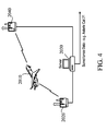
- Where three receivers are able to receive the signal, the ADS-B self-reports can be validated by traditional multilateration systems, which can derive an independent position report for the aircraft.
- Where two receivers are able to receive the signal, the ADS-B self-reports can be validated by the TDOA validation method described in the present invention.
- Where only a single receiver is in range, there is no independent validation of ADS-B reports, although a surveillance system may assess the self-reported position based on tracking the aircraft from its last validated position. Based upon reported position and speed, a subsequent time-stamp can be predicted, and then compared to an actual subsequent time-stamp received at the same location.
Claims (5)
Priority Applications (1)
| Application Number | Priority Date | Filing Date | Title |
|---|---|---|---|
| US12/471,384 US8072382B2 (en) | 1999-03-05 | 2009-06-06 | Method and apparatus for ADS-B validation, active and passive multilateration, and elliptical surveillance |
Applications Claiming Priority (16)
| Application Number | Priority Date | Filing Date | Title |
|---|---|---|---|
| US12317099P | 1999-03-05 | 1999-03-05 | |
| US09/516,215 US6633259B1 (en) | 1999-03-05 | 2000-02-29 | Method and apparatus for improving utility of automatic dependent surveillance |
| US10/319,725 US6812890B2 (en) | 2000-02-29 | 2002-12-16 | Voice recognition landing fee billing system |
| US44061803P | 2003-01-17 | 2003-01-17 | |
| US10/638,524 US6806829B2 (en) | 1999-03-05 | 2003-08-12 | Method and apparatus for improving the utility of a automatic dependent surveillance |
| US10/743,042 US7132982B2 (en) | 1999-03-05 | 2003-12-23 | Method and apparatus for accurate aircraft and vehicle tracking |
| US11/145,170 US7437250B2 (en) | 1999-03-05 | 2005-06-06 | Airport pavement management system |
| US11/203,823 US7739167B2 (en) | 1999-03-05 | 2005-08-15 | Automated management of airport revenues |
| US11/209,030 US7248219B2 (en) | 2000-02-29 | 2005-08-22 | Correlation of flight track data with other data sources |
| US11/257,416 US7495612B2 (en) | 1999-03-05 | 2005-10-24 | Method and apparatus to improve ADS-B security |
| US11/342,289 US7576695B2 (en) | 1999-03-05 | 2006-01-28 | Multilateration enhancements for noise and operations management |
| US11/343,079 US7375683B2 (en) | 1999-03-05 | 2006-01-30 | Use of geo-stationary satellites to augment wide— area multilateration synchronization |
| US11/429,926 US7477193B2 (en) | 1999-03-05 | 2006-05-08 | Method and system for elliptical-based surveillance |
| US11/492,711 US7429950B2 (en) | 1999-03-05 | 2006-07-25 | Method and apparatus to extend ADS performance metrics |
| US11/541,480 US7570214B2 (en) | 1999-03-05 | 2006-09-29 | Method and apparatus for ADS-B validation, active and passive multilateration, and elliptical surviellance |
| US12/471,384 US8072382B2 (en) | 1999-03-05 | 2009-06-06 | Method and apparatus for ADS-B validation, active and passive multilateration, and elliptical surveillance |
Related Parent Applications (1)
| Application Number | Title | Priority Date | Filing Date |
|---|---|---|---|
| US11/541,480 Division US7570214B2 (en) | 1999-03-05 | 2006-09-29 | Method and apparatus for ADS-B validation, active and passive multilateration, and elliptical surviellance |
Publications (2)
| Publication Number | Publication Date |
|---|---|
| US20100149019A1 US20100149019A1 (en) | 2010-06-17 |
| US8072382B2 true US8072382B2 (en) | 2011-12-06 |
Family
ID=38891633
Family Applications (2)
| Application Number | Title | Priority Date | Filing Date |
|---|---|---|---|
| US11/541,480 Expired - Fee Related US7570214B2 (en) | 1999-03-05 | 2006-09-29 | Method and apparatus for ADS-B validation, active and passive multilateration, and elliptical surviellance |
| US12/471,384 Expired - Lifetime US8072382B2 (en) | 1999-03-05 | 2009-06-06 | Method and apparatus for ADS-B validation, active and passive multilateration, and elliptical surveillance |
Family Applications Before (1)
| Application Number | Title | Priority Date | Filing Date |
|---|---|---|---|
| US11/541,480 Expired - Fee Related US7570214B2 (en) | 1999-03-05 | 2006-09-29 | Method and apparatus for ADS-B validation, active and passive multilateration, and elliptical surviellance |
Country Status (3)
| Country | Link |
|---|---|
| US (2) | US7570214B2 (en) |
| EP (1) | EP1906204B1 (en) |
| DE (1) | DE602007004050D1 (en) |
Cited By (19)
| Publication number | Priority date | Publication date | Assignee | Title |
|---|---|---|---|---|
| US20120214420A1 (en) * | 2009-10-22 | 2012-08-23 | O'connor Daniel | Aircraft Communication System |
| US20140002293A1 (en) * | 2011-03-11 | 2014-01-02 | Jorg Behrens | Satellite communication network |
| US20140070979A1 (en) * | 2008-06-18 | 2014-03-13 | Saab Ab | Validity check of vehicle position information |
| US8890744B1 (en) | 1999-04-07 | 2014-11-18 | James L. Geer | Method and apparatus for the detection of objects using electromagnetic wave attenuation patterns |
| US9116240B2 (en) | 2012-04-04 | 2015-08-25 | Mosaic Atm, Inc. | System and method for ensuring ADS-B integrity of departing aircraft |
| US9310477B1 (en) | 2013-01-29 | 2016-04-12 | The Boeing Company | Systems and methods for monitoring airborne objects |
| US9476962B2 (en) | 2013-05-02 | 2016-10-25 | The Boeing Company | Device, system and methods using angle of arrival measurements for ADS-B authentication and navigation |
| US9824591B1 (en) * | 2014-10-28 | 2017-11-21 | Rockwell Collins, Inc. | Multi-media analysis for implementing advanced flight following and generating of projected tracks |
| CN107771291A (en) * | 2015-04-27 | 2018-03-06 | 祖迪雅克数据系统公司 | For handling the signal from transmitter with the system and correlation reception website of timing signal and location transmitters |
| US10001546B2 (en) * | 2014-12-02 | 2018-06-19 | Sita Information Networking Computing Uk Limited | Apparatus for monitoring aircraft position |
| US10185031B2 (en) * | 2015-11-24 | 2019-01-22 | The Boeing Company | Passive radar weather detection systems and methods |
| US10234303B1 (en) | 2018-02-28 | 2019-03-19 | Honeywell International Inc. | Methods and systems for providing visually automated in-cockpit aircraft docking guidance with use of airport moving map applications |
| US10410530B1 (en) | 2018-02-27 | 2019-09-10 | Honeywell International Inc. | Systems and methods for detecting potential surface collisions and providing warnings onboard an aircraft or airport vehicle |
| WO2020095195A1 (en) * | 2018-11-05 | 2020-05-14 | Iatas (Automatic Air Traffic Control) Ltd | Systems and methods for autonomous global atfm/acdm synchronization with ansp clearance, inflight dispatch and deviation alerts |
| US10733894B1 (en) | 2015-08-24 | 2020-08-04 | uAvionix Corporation | Direct-broadcast remote identification (RID) device for unmanned aircraft systems (UAS) |
| US10743141B2 (en) | 2018-06-05 | 2020-08-11 | Kenmar Corporation | Systems and methods for determining a location of an electronic device using bilateration |
| US10991260B2 (en) | 2015-08-24 | 2021-04-27 | uAvionix Corporation | Intelligent non-disruptive automatic dependent surveillance-broadcast (ADS-B) integration for unmanned aircraft systems (UAS) |
| US20210181355A1 (en) * | 2019-12-17 | 2021-06-17 | Aireon Llc | Decoding position information |
| US11222547B2 (en) | 2015-08-24 | 2022-01-11 | Uavionics Corporation | Intelligent non-disruptive automatic dependent surveillance-broadcast (ADS-B) integration for unmanned aircraft systems (UAS) |
Families Citing this family (57)
| Publication number | Priority date | Publication date | Assignee | Title |
|---|---|---|---|---|
| US8446321B2 (en) | 1999-03-05 | 2013-05-21 | Omnipol A.S. | Deployable intelligence and tracking system for homeland security and search and rescue |
| US7777675B2 (en) | 1999-03-05 | 2010-08-17 | Era Systems Corporation | Deployable passive broadband aircraft tracking |
| US8203486B1 (en) | 1999-03-05 | 2012-06-19 | Omnipol A.S. | Transmitter independent techniques to extend the performance of passive coherent location |
| US7667647B2 (en) | 1999-03-05 | 2010-02-23 | Era Systems Corporation | Extension of aircraft tracking and positive identification from movement areas into non-movement areas |
| US7570214B2 (en) | 1999-03-05 | 2009-08-04 | Era Systems, Inc. | Method and apparatus for ADS-B validation, active and passive multilateration, and elliptical surviellance |
| US7889133B2 (en) | 1999-03-05 | 2011-02-15 | Itt Manufacturing Enterprises, Inc. | Multilateration enhancements for noise and operations management |
| US7782256B2 (en) | 1999-03-05 | 2010-08-24 | Era Systems Corporation | Enhanced passive coherent location techniques to track and identify UAVs, UCAVs, MAVs, and other objects |
| US7739167B2 (en) | 1999-03-05 | 2010-06-15 | Era Systems Corporation | Automated management of airport revenues |
| US7908077B2 (en) | 2003-06-10 | 2011-03-15 | Itt Manufacturing Enterprises, Inc. | Land use compatibility planning software |
| US7826839B1 (en) * | 2006-01-30 | 2010-11-02 | Rockwell Collins, Inc. | Communication system to facilitate airborne electronic attack |
| US7965227B2 (en) | 2006-05-08 | 2011-06-21 | Era Systems, Inc. | Aircraft tracking using low cost tagging as a discriminator |
| US20070282492A1 (en) * | 2006-05-31 | 2007-12-06 | Sensis Corporation | Method and system of managing data transmissions from broadcast-equipped targets |
| FR2903499B1 (en) * | 2006-07-05 | 2008-08-22 | Alcatel Sa | INTEGRITY MESSAGE GENERATING DEVICE SIGNALING NOMINAL, DEGRADED OR INACCURATE SURVEILLANCE STATIONS OF SATELLITE NAVIGATION SYSTEMS |
| US9037317B2 (en) * | 2006-12-21 | 2015-05-19 | The Boeing Company | System and method for automatic dependent surveillance collection and analysis |
| US8386175B2 (en) * | 2008-02-15 | 2013-02-26 | Kutta Technologies, Inc. | Unmanned aerial system position reporting system |
| US9595198B2 (en) * | 2008-02-15 | 2017-03-14 | Kutta Technologies, Inc. | Unmanned aerial system position reporting system |
| DE102008013357B4 (en) * | 2008-03-10 | 2019-03-07 | Thales Alenia Space Deutschland Gmbh | Arrangement and method for air traffic control and / or flight guidance of aircraft |
| US10338210B2 (en) * | 2008-04-17 | 2019-07-02 | Aviation Communication & Surveillance Systems Llc | Systems and methods for providing GPS alternatives on 1090 MHz |
| GB0807586D0 (en) | 2008-04-26 | 2008-06-04 | Roke Manor Research | A multilateration system and method |
| EP2136221B1 (en) * | 2008-06-18 | 2013-10-09 | Saab Ab | Validity check of vehicle position information transmitted over a time-synchronized data link |
| WO2010045299A1 (en) * | 2008-10-14 | 2010-04-22 | Raytheon Company | Bi-static radar processing for ads-b sensors |
| WO2011009109A2 (en) * | 2009-07-17 | 2011-01-20 | Sensis Corporation | System and method for aircraft navigation using signals transmitted in the dme transponder frequency range |
| WO2011011360A1 (en) * | 2009-07-20 | 2011-01-27 | Sensis Corporation | System and method for providing timing services and dme aided multilateration for ground surveillance |
| WO2011019978A1 (en) * | 2009-08-14 | 2011-02-17 | Sensis Corporation | System and method for gnss in-band authenticated position determination |
| FR2949867B1 (en) * | 2009-09-04 | 2012-04-27 | Thales Sa | MULTIFUNCTION AIRBORNE RADAR DEVICE WITH BROADBAND LARGE ANGULAR COVERAGE FOR DETECTION AND TRACKING, IN PARTICULAR FOR A DETECTION AND EVACUATION FUNCTION |
| US9052375B2 (en) * | 2009-09-10 | 2015-06-09 | The Boeing Company | Method for validating aircraft traffic control data |
| PL2296128T3 (en) * | 2009-09-10 | 2013-12-31 | Thales Alenia Space Deutschland Gmbh | ADS-B monitoring and broadcasting services for global air traffic management using satellites |
| EP2548041B1 (en) * | 2010-03-17 | 2016-07-27 | Honeywell International Inc. | Systems and methods for short baseline, low cost determination of airborne aircraft location |
| US20120299763A1 (en) * | 2011-05-27 | 2012-11-29 | Avidyne Corporation | Position determining method and system using surveillance ground stations |
| US9285472B2 (en) | 2011-12-06 | 2016-03-15 | L-3 Communications Avionics Systems, Inc. | Multi-link transponder for aircraft and method of providing multi-link transponder capability to an aircraft having an existing transponder |
| US9024817B2 (en) | 2011-12-09 | 2015-05-05 | Honeywell International Inc. | Systems and methods for receiving aircraft position reports |
| US9696407B1 (en) * | 2012-08-07 | 2017-07-04 | Rockwell Collins, Inc. | Backup navigation position determination using surveillance information |
| US9383429B2 (en) * | 2012-10-17 | 2016-07-05 | Raytheon Applied Signal Technology, Inc. | System and method for determining geo location of a target using locus of emitter positions (LEP) |
| US9182484B2 (en) * | 2013-01-11 | 2015-11-10 | Garmin International, Inc. | Traffic information services-broadcast (TIS-B) automatic address detection and coverage indication |
| US20140303929A1 (en) * | 2013-04-03 | 2014-10-09 | Umm Al-Qura University | Method to obtain accurate vertical component estimates in 3d positioning |
| CN103413463B (en) * | 2013-08-07 | 2015-08-26 | 四川九洲空管科技有限责任公司 | The data of a kind of ADS-B target and radar target hold fusion implementation method |
| CN104155654A (en) * | 2014-08-13 | 2014-11-19 | 芜湖航飞科技股份有限公司 | Airborne radar |
| EP3088911B1 (en) | 2015-04-20 | 2019-03-13 | The Boeing Company | A method of communicating airborne multilateration information |
| EP3154046B1 (en) * | 2015-10-05 | 2021-12-08 | The Boeing Company | System and method for verifying ads-b messages |
| US10901093B2 (en) * | 2017-01-11 | 2021-01-26 | Aireon Llc | Position validation |
| SG10201702321PA (en) * | 2017-03-22 | 2018-10-30 | Hian Lim Chan | Global integrity check system and associated method |
| US10137863B2 (en) | 2017-03-23 | 2018-11-27 | Honeywell International Inc. | Detecting false positioning signals based on surveillance signals |
| US10554412B2 (en) | 2018-03-06 | 2020-02-04 | Robust Analytics, Inc. | Method and network to implement decentralized validation and authentication mechanisms to prevent ADS-B cyber-attacks |
| WO2019218114A1 (en) * | 2018-05-14 | 2019-11-21 | Lenovo (Beijing) Limited | Method and apparatus for flight path information reporting |
| US10650687B2 (en) * | 2018-05-18 | 2020-05-12 | Aireon Llc | Decoding position information in space-based systems |
| US11167836B2 (en) | 2018-06-21 | 2021-11-09 | Sierra Nevada Corporation | Devices and methods to attach composite core to a surrounding structure |
| EP3654060B1 (en) | 2018-11-13 | 2022-05-11 | Thales Management & Services Deutschland GmbH | A system and a method for determining the position of an aircraft |
| WO2020110040A1 (en) * | 2018-11-27 | 2020-06-04 | Leonardo S.P.A. | Suborbital space traffic control system with radar system and ads-b receiver |
| CN110071784B (en) * | 2019-04-25 | 2020-08-18 | 电子科技大学 | Aircraft positioning method in ADS-B aviation monitoring system |
| CN110224743B (en) * | 2019-06-24 | 2021-04-13 | 中国电子科技集团公司第五十四研究所 | Dynamic scene-based forming method of satellite-borne ADS-B test signal |
| CN111212059B (en) * | 2019-12-31 | 2022-04-08 | 北航(四川)西部国际创新港科技有限公司 | Distributed information processing method and system based on ADS-B |
| CN112147574B (en) * | 2020-09-25 | 2022-02-01 | 四川九洲电器集团有限责任公司 | Multi-station positioning algorithm verification method and simulation system |
| US11585942B2 (en) | 2020-10-26 | 2023-02-21 | Honeywell International Inc. | Detection of GNSS interference using surveillance messages |
| CN113163335A (en) * | 2021-03-12 | 2021-07-23 | 中航空管系统装备有限公司 | Fusion and forwarding system for ADS-B data |
| CN113759403A (en) * | 2021-09-03 | 2021-12-07 | 四川九洲空管科技有限责任公司 | Target verification method of satellite-based ADS-B |
| WO2024028342A1 (en) * | 2022-08-01 | 2024-02-08 | European Space Agency | Methods and apparatus for positioning of a mobile terminal |
| GB2621890A (en) * | 2022-08-26 | 2024-02-28 | Zekavica Dorde | A system and method for providing reliable aircraft information from air band data |
Citations (622)
| Publication number | Priority date | Publication date | Assignee | Title |
|---|---|---|---|---|
| US1738571A (en) | 1927-08-19 | 1929-12-10 | Gare Thomas | Wearing surface of pavements, roads, treads, and the like |
| US3668403A (en) | 1969-05-05 | 1972-06-06 | Goodyear Aerospace Corp | Method and apparatus for vehicle traffic control |
| US3705404A (en) | 1969-11-17 | 1972-12-05 | John P Chisholm | Aircraft clock monitoring and time propagating |
| US3792472A (en) | 1972-08-14 | 1974-02-12 | Bendix Corp | Warning indicator to alert aircraft pilot to presence and bearing of other aircraft |
| US4079414A (en) | 1970-04-21 | 1978-03-14 | Skiatron Electronics & Television Corporation | Interrogated transponder system |
| US4115771A (en) | 1976-05-11 | 1978-09-19 | Litchstreet Co. | Passive ATCRBS using signals of remote SSR |
| US4122522A (en) | 1974-05-20 | 1978-10-24 | Smith Gerald R | Aircraft ground monitoring system |
| US4167006A (en) | 1976-10-22 | 1979-09-04 | Toyo Tsushinki Kabushiki Kaisha | Collision avoidance system of aircraft |
| US4196474A (en) | 1974-02-11 | 1980-04-01 | The Johns Hopkins University | Information display method and apparatus for air traffic control |
| US4224669A (en) | 1977-12-22 | 1980-09-23 | The Boeing Company | Minimum safe altitude monitoring, indication and warning system |
| US4229737A (en) | 1978-02-06 | 1980-10-21 | Cubic Western Data | Ranging system and method for determining the range of a vehicle from a plurality of reference points |
| US4293857A (en) | 1979-08-10 | 1981-10-06 | Baldwin Edwin L | Collision avoidance warning system |
| US4315609A (en) | 1971-06-16 | 1982-02-16 | The United States Of America As Represented By The Secretary Of The Navy | Target locating and missile guidance system |
| US4327437A (en) | 1980-07-30 | 1982-04-27 | Nasa | Reconfiguring redundancy management |
| US4359733A (en) | 1980-09-23 | 1982-11-16 | Neill Gerard K O | Satellite-based vehicle position determining system |
| US4454510A (en) | 1978-12-18 | 1984-06-12 | Crow Robert P | Discrete address beacon, navigation and landing system (DABNLS) |
| US4524931A (en) | 1980-11-12 | 1985-06-25 | Ingeniorsfirma N.D.C. Netzler & Dahlgren Co Aktiebolag | Device for indicating a certain proximity between movable units |
| US4646244A (en) | 1984-02-02 | 1987-02-24 | Sundstrand Data Control, Inc. | Terrain advisory system |
| US4688046A (en) | 1982-09-13 | 1987-08-18 | Isc Cardion Electronics, Inc. | ADF bearing and location for use with ASR and ASDE displays |
| EP0265902A2 (en) | 1986-10-31 | 1988-05-04 | Deutsches Zentrum für Luft- und Raumfahrt e.V. | Method of determining the position of an aircraft in a three-way DME system |
| US4782450A (en) | 1985-08-27 | 1988-11-01 | Bennett Flax | Method and apparatus for passive airborne collision avoidance and navigation |
| US4811308A (en) | 1986-10-29 | 1989-03-07 | Michel Howard E | Seismo-acoustic detection, identification, and tracking of stealth aircraft |
| US4843397A (en) | 1987-03-26 | 1989-06-27 | Selenia Spazio Spa | Distributed-array radar system comprising an array of interconnected elementary satellites |
| US4853700A (en) | 1984-10-29 | 1989-08-01 | Toyo Communication Equipment Co., Ltd. | Indicating system for warning airspace or threatening aircraft in aircraft collision avoidance system |
| EP0346461A1 (en) | 1987-10-23 | 1989-12-20 | Hughes Aircraft Company | Vehicle location system accuracy enhancement for airborne vehicles |
| US4897661A (en) | 1987-04-10 | 1990-01-30 | Sony Corporation | Method and apparatus for determining the position of a vehicle |
| US4899296A (en) | 1987-11-13 | 1990-02-06 | Khattak Anwar S | Pavement distress survey system |
| US4910526A (en) | 1987-05-18 | 1990-03-20 | Avion Systems, Inc. | Airborne surveillance method and system |
| US4914733A (en) | 1987-10-30 | 1990-04-03 | Allied-Signal, Inc. | Traffic advisory-instantaneous vertical speed display |
| US4958306A (en) | 1988-01-06 | 1990-09-18 | Pacific Northwest Research & Development, Inc. | Pavement inspection apparatus |
| US5001650A (en) | 1989-04-10 | 1991-03-19 | Hughes Aircraft Company | Method and apparatus for search and tracking |
| US5001490A (en) | 1989-08-08 | 1991-03-19 | Siemens Aktiengesellschaft | Multifunction radar techniques |
| US5017930A (en) | 1990-01-25 | 1991-05-21 | John R. Stoltz | Precision landing system |
| US5025382A (en) | 1989-12-12 | 1991-06-18 | The Mitre Corporation | Datalink controller interface |
| US5027114A (en) | 1987-06-09 | 1991-06-25 | Kiroshi Kawashima | Ground guidance system for airplanes |
| US5045861A (en) | 1987-08-10 | 1991-09-03 | The Lynxvale - Cril Partnership | Navigation and tracking system |
| US5075694A (en) | 1987-05-18 | 1991-12-24 | Avion Systems, Inc. | Airborne surveillance method and system |
| US5075680A (en) | 1990-09-14 | 1991-12-24 | Dabbs John W T | Method and apparatus for monitoring vehicular traffic |
| US5081457A (en) | 1989-11-30 | 1992-01-14 | Honeywell Inc. | Apparatus for reducing synchronous fruit in tcas surveillance systems |
| US5089822A (en) | 1990-02-13 | 1992-02-18 | Avion Systems, Inc. | Interrogation signal processor for air traffic control communications |
| WO1992005456A1 (en) | 1990-09-26 | 1992-04-02 | Rowe, Deines Instruments Incorporated | Acoustic doppler current profiler |
| US5113193A (en) | 1985-11-12 | 1992-05-12 | The United States Of America As Represented By The Secretary Of The Air Force | Autonomous synchronization of a bistatic synthetic aperture radar (SAR) system |
| US5119102A (en) | 1990-02-28 | 1992-06-02 | U.S. Philips Corporation | Vehicle location system |
| US5132695A (en) | 1988-02-01 | 1992-07-21 | Thomson Csf | Radio navigation system |
| US5138321A (en) | 1991-10-15 | 1992-08-11 | International Business Machines Corporation | Method for distributed data association and multi-target tracking |
| US5144315A (en) | 1989-02-10 | 1992-09-01 | Cardion, Inc. | System for accurately monitoring aircraft position during training exercises |
| US5153836A (en) | 1990-08-22 | 1992-10-06 | Edward J. Fraughton | Universal dynamic navigation, surveillance, emergency location, and collision avoidance system and method |
| EP0514826A1 (en) | 1991-05-22 | 1992-11-25 | NFS Navigations- und Flugführungs-Systeme GmbH | Traffic conditions detection method and arrangement |
| US5179384A (en) | 1990-07-13 | 1993-01-12 | Haan Frans H De | Device for identifying and localizing transponders |
| US5191342A (en) | 1981-08-06 | 1993-03-02 | The United States Of America As Represented By The Secretary Of The Navy | Fix-tracking system |
| US5200902A (en) | 1990-10-09 | 1993-04-06 | Pilley Harold R | Airport control/management system |
| US5225842A (en) | 1991-05-09 | 1993-07-06 | Navsys Corporation | Vehicle tracking system employing global positioning system (gps) satellites |
| EP0550073A2 (en) | 1991-12-30 | 1993-07-07 | Deutsches Zentrum für Luft- und Raumfahrt e.V. | System for locating multiple objects and obstacles and for detecting and determining the rolling state of moving objects, such as aircraft, ground vehicles, etc. |
| DE4204164A1 (en) | 1992-02-13 | 1993-08-19 | Deutsche Aerospace | Position and mission data unit for GPS flight navigation and flight data processing - has display for aeroplanes and helicopters used in general air traffic supported by global positioning satellite system and data unit of modular design |
| US5260702A (en) | 1989-12-27 | 1993-11-09 | Thompson Keith P | Aircraft information system |
| US5262784A (en) | 1992-06-15 | 1993-11-16 | Cardion, Inc. | System for monitoring aircraft position |
| US5265023A (en) | 1990-07-27 | 1993-11-23 | Mitre Corporation | Method for issuing adaptive ground delays to air traffic |
| US5268698A (en) | 1992-07-31 | 1993-12-07 | Smith Sr Louis P | Target acquisition, locating and tracking system |
| US5283574A (en) | 1985-02-22 | 1994-02-01 | Sundstrand Data Control, Inc. | Altitude loss after take-off warning system utilizing time and altitude |
| US5311194A (en) | 1992-09-15 | 1994-05-10 | Navsys Corporation | GPS precision approach and landing system for aircraft |
| US5317316A (en) | 1992-12-22 | 1994-05-31 | Honeywell Inc. | Method of altitude track initialization in an aircraft tracking system |
| US5317317A (en) | 1992-03-10 | 1994-05-31 | Thomson-Csf | Method and device to detect the garbling of pulses received by a secondary radar by phase analysis |
| EP0574009A3 (en) | 1992-06-12 | 1994-06-22 | Tokyo Cosmos Co Ltd | Dgps positioning method, dgps reference station and dgps positioning apparatus for moving object |
| US5339281A (en) | 1993-08-05 | 1994-08-16 | Alliant Techsystems Inc. | Compact deployable acoustic sensor |
| US5341139A (en) | 1992-03-31 | 1994-08-23 | Thomson-Csf | Method and device to detect the garbling of pulses received by a secondary radar |
| EP0613110A1 (en) | 1993-02-26 | 1994-08-31 | Raytheon Company | Airport incursion avoidance system |
| EP0613111A1 (en) | 1993-02-26 | 1994-08-31 | Raytheon Company | Airport surveillance system |
| EP0614092A1 (en) | 1993-03-03 | 1994-09-07 | Hollandse Signaalapparaten B.V. | Radar apparatus |
| DE4306660A1 (en) | 1993-03-03 | 1994-09-08 | Siemens Ag | System for locating and identifying vehicles on an airfield |
| US5365516A (en) | 1991-08-16 | 1994-11-15 | Pinpoint Communications, Inc. | Communication system and method for determining the location of a transponder unit |
| WO1994027161A1 (en) | 1993-05-07 | 1994-11-24 | Associated Rt, Inc. | System for locating a source of bursty transmissions |
| WO1994028437A1 (en) | 1993-05-27 | 1994-12-08 | Westinghouse Electric Corporation | Airport surface vehicule identification |
| US5374932A (en) | 1993-08-02 | 1994-12-20 | Massachusetts Institute Of Technology | Airport surface surveillance system |
| EP0629877A1 (en) | 1993-06-21 | 1994-12-21 | State Of Israel Ministry Of Defence Rafael Armament Development Authority | GPS-aided dead reckoning navigation |
| US5379224A (en) | 1991-11-29 | 1995-01-03 | Navsys Corporation | GPS tracking system |
| US5381140A (en) | 1992-02-18 | 1995-01-10 | Kabushiki Kaisha Toshiba | Aircraft position monitoring system |
| WO1995003598A1 (en) | 1993-07-20 | 1995-02-02 | Philip Bernard Wesby | Locating/map dissemination system |
| FR2708349A1 (en) | 1993-07-26 | 1995-02-03 | Sextant Avionique | Method of locating an aircraft in flight with the aid of a satellite positioning system |
| US5402116A (en) | 1992-04-28 | 1995-03-28 | Hazeltine Corp. | Atmospheric pressure calibration systems and methods |
| US5406288A (en) | 1992-06-30 | 1995-04-11 | Thomson-Csf | Method and device to improve the probability of validity of the codes of secondary radar responses |
| US5424746A (en) | 1993-11-16 | 1995-06-13 | Cardion, Inc. | Method and system for monitoring vehicles |
| US5424748A (en) | 1992-11-06 | 1995-06-13 | Thomson-Csf | Radar antenna suitable for designation and trajectography radar |
| US5438337A (en) | 1993-09-24 | 1995-08-01 | Northrop Grumman Corporation | Navigation system using re-transmitted GPS |
| WO1995021388A1 (en) | 1994-02-04 | 1995-08-10 | Stanford Telecommunications, Inc. | Air traffic surveillance and communication system |
| EP0355336B1 (en) | 1988-08-04 | 1995-08-16 | Siemens-Albis Aktiengesellschaft | Radar system for position determination of two or more objects |
| US5448233A (en) | 1993-01-28 | 1995-09-05 | State Of Israel, Rafael Armament Development Authority | Airborne obstacle collision avoidance apparatus |
| EP0670566A2 (en) | 1994-02-04 | 1995-09-06 | Avco Corporation | Hybrid synthetic aircraft landing system |
| US5450329A (en) | 1993-12-22 | 1995-09-12 | Tanner; Jesse H. | Vehicle location method and system |
| US5454720A (en) | 1994-05-31 | 1995-10-03 | Motorola, Inc. | Method for elimination of ambiguous solutions in a hyperbolic positioning system |
| US5455586A (en) | 1992-06-30 | 1995-10-03 | Thomson-Csf | Pulse recognition method and device, and use thereof for the filtering of the S mode responses of a secondary radar |
| EP0682332A1 (en) | 1994-05-11 | 1995-11-15 | Alcatel Air Navigation Systems S.r.l. | System for the precision approach of mobile vehicles to points equipped for such a purpose |
| US5471657A (en) | 1992-12-04 | 1995-11-28 | Hughes Aircraft Company | Frequency tuning for satellite ground stations |
| US5486829A (en) | 1993-07-09 | 1996-01-23 | Thomson-Csf | Method of communicating information between an S-mode secondary radar and a target |
| US5493309A (en) | 1993-09-24 | 1996-02-20 | Motorola, Inc. | Collison avoidance communication system and method |
| WO1996005562A1 (en) | 1994-08-16 | 1996-02-22 | Worldwide Notification Systems, Inc. | Satellite based collision avoidance system |
| US5506590A (en) | 1990-08-13 | 1996-04-09 | Minter; Jerry B. | Pilot warning system |
| US5515286A (en) | 1994-03-24 | 1996-05-07 | Sextant Avionique | Method and device for preventing aerodynes from colliding with relief obstacles |
| EP0505827B1 (en) | 1991-03-27 | 1996-06-12 | Alcatel SEL Aktiengesellschaft | Secondary radar system |
| US5528244A (en) | 1995-03-31 | 1996-06-18 | Cardion, Inc. | Processing for mode S signals suffering multipath distortion |
| US5534871A (en) | 1994-04-22 | 1996-07-09 | Mitsubishi Precision Co., Ltd. | Apparatus for measuring physical quantity related to relative movement between two objects |
| EP0385600B1 (en) | 1989-02-10 | 1996-07-24 | Cardion, Inc. | System for tracking an aircraft over an area |
| US5541608A (en) | 1995-03-29 | 1996-07-30 | Itt Corporation | Hybrid amplitude/phase comparison direction finding system |
| EP0732596A2 (en) | 1995-03-13 | 1996-09-18 | Vaisala Oy | Codeless GPS positioning method and apparatus for such codeless positioning |
| US5570099A (en) | 1993-10-15 | 1996-10-29 | Loral Federal Systems Company | TDOA/FDOA technique for locating a transmitter |
| US5570095A (en) | 1994-04-01 | 1996-10-29 | Massachusetts Institute Of Technology | Automatic dependent surveillance air navigation system |
| WO1996035961A1 (en) | 1995-05-09 | 1996-11-14 | Helfgott & Karas, P.C. | Airport surface detection radar |
| US5583775A (en) | 1994-04-28 | 1996-12-10 | Pioneer Electronic Corporation | Navigation apparatus and navigation method |
| US5590044A (en) | 1994-02-02 | 1996-12-31 | Deutsche Forschungsanstalt Fur Luft- Und Raumfahrt E.V. | Method and apparatus for finding aircraft position by integrating accelerations less time averages |
| US5596326A (en) | 1995-07-17 | 1997-01-21 | Northrop Grumman Corporation | Secondary surveillance radar interrogation system using dual frequencies |
| US5596332A (en) | 1994-04-19 | 1997-01-21 | Northrop Corporation | Aircraft location and identification system |
| EP0487940B1 (en) | 1990-11-28 | 1997-01-22 | Siemens Aktiengesellschaft | Pulse doppler radar |
| US5608412A (en) | 1995-06-07 | 1997-03-04 | General Electric Company | Protocol and mechanism for mutter mode communication for stationary master tracking unit |
| US5614912A (en) | 1991-09-09 | 1997-03-25 | The Mitre Corporation | Radar processing method and apparatus |
| US5617101A (en) | 1994-12-27 | 1997-04-01 | Motorola, Inc. | Satellite-based geolocation calibration system and method |
| US5627546A (en) | 1995-09-05 | 1997-05-06 | Crow; Robert P. | Combined ground and satellite system for global aircraft surveillance guidance and navigation |
| US5629691A (en) | 1995-05-26 | 1997-05-13 | Hughes Electronics | Airport surface monitoring and runway incursion warning system |
| EP0774148A1 (en) | 1994-07-15 | 1997-05-21 | Worldwide Notification Systems, Inc. | Satellite based aircraft traffic control system |
| US5635693A (en) | 1995-02-02 | 1997-06-03 | International Business Machines Corporation | System and method for tracking vehicles in vehicle lots |
| WO1997026552A2 (en) | 1996-01-20 | 1997-07-24 | Klaschka Ruediger | Device for monitoring the distance between two objects |
| US5659319A (en) | 1995-12-21 | 1997-08-19 | Cardion, Inc. | Method and apparatus for operating a surface detection surveillance radar using frequency agile pulse transmissions |
| US5666110A (en) | 1995-03-09 | 1997-09-09 | Paterson; Noel S. | Helicopter enhanced descent after take-off warning for GPWS |
| US5670960A (en) | 1994-12-07 | 1997-09-23 | Dassault Electronique | Device for the detection and location of objects on the ground |
| US5670961A (en) | 1994-11-24 | 1997-09-23 | Mitsubishi Denki Kabushiki Kaisha | Airport surface traffic control system |
| US5677841A (en) | 1994-03-11 | 1997-10-14 | Kabushiki Kaisha Toshiba | Control target surveillance system |
| US5680140A (en) | 1994-07-19 | 1997-10-21 | Trimble Navigation Limited | Post-processing of inverse differential corrections for SATPS mobile stations |
| US5686921A (en) | 1994-12-20 | 1997-11-11 | Honda Giken Kogyo Kabushiki Kaisha | Radar system |
| US5694322A (en) | 1995-05-09 | 1997-12-02 | Highwaymaster Communications, Inc. | Method and apparatus for determining tax of a vehicle |
| WO1997047173A2 (en) | 1996-06-03 | 1997-12-18 | Mcdonnell Douglas Helicopter Company | Portable flight guidance and tracking system |
| US5714948A (en) | 1993-05-14 | 1998-02-03 | Worldwide Notifications Systems, Inc. | Satellite based aircraft traffic control system |
| WO1998004965A2 (en) | 1996-07-16 | 1998-02-05 | Colorado State University Research Foundation | Method and system for tracking multiple regional objects by multi-dimensional relaxation |
| WO1998005977A1 (en) | 1996-08-01 | 1998-02-12 | Era A.S. | A process for location of objects, mainly aircraft, and a system for carrying out this process |
| US5732384A (en) | 1995-09-08 | 1998-03-24 | Hughes Aircraft | Graphical user interface for air traffic control flight data management |
| WO1998014926A1 (en) | 1996-10-04 | 1998-04-09 | Global Research Systems, Inc. | Advance notification system for use with vehicular transportation |
| EP0578316B1 (en) | 1992-07-06 | 1998-04-29 | Societe Francaise De Production Et De Creation Audiovisuelles S.F.P. | Method and system for pointing one antenna in the direction of the other |
| US5752216A (en) | 1994-07-06 | 1998-05-12 | Dimensions International, Inc. | Non-intrusive data interface system for air traffic control |
| US5757314A (en) | 1995-06-06 | 1998-05-26 | Dassault Sercel Navigation-Positionnement | Method and apparatus for accurately determining the position of a masked point by satellite |
| WO1998022923A1 (en) | 1996-11-15 | 1998-05-28 | Siemens Aktiengesellschaft | Terminal co-ordination system for airports |
| WO1998022834A1 (en) | 1996-11-22 | 1998-05-28 | Itt Manufacturing Enterprises, Inc. | Integrated precision approach radar display |
| US5774829A (en) | 1995-12-12 | 1998-06-30 | Pinterra Corporation | Navigation and positioning system and method using uncoordinated beacon signals in conjunction with an absolute positioning system |
| US5781150A (en) | 1995-01-25 | 1998-07-14 | American Technology Corporation | GPS relative position detection system |
| US5784022A (en) | 1995-12-19 | 1998-07-21 | Siemens Switzerland Ag | Process and amplitude or phase monopulse radar device for locating flying objects |
| US5793329A (en) | 1995-07-17 | 1998-08-11 | The Nippon Signal Co., Ltd. | Object detection apparatus |
| WO1998035311A1 (en) | 1997-02-06 | 1998-08-13 | Delorme Publishing Company, Inc. | Travel reservation and information planning system |
| US5798712A (en) | 1994-12-15 | 1998-08-25 | Aerospatiale Societe Nationale Industrielle | Method and device for supplying information, an alert or alarm for an aircraft in proximity to the ground |
| US5802542A (en) | 1994-03-24 | 1998-09-01 | Hewlett-Packard Laboratories | Information management system for a dynamic system and method thereof |
| WO1998043107A1 (en) | 1997-03-27 | 1998-10-01 | Hedrick Geoffrey S M | Satellite-based collision avoidance system and method therefor |
| US5825021A (en) | 1996-02-28 | 1998-10-20 | Nec Corporation | Apparatus for detecting that a flying object has passed a monitoring space |
| US5828333A (en) | 1997-01-21 | 1998-10-27 | Northrop Grumman Corporation | Multiple access diplex doppler radar |
| WO1998049654A1 (en) | 1997-04-25 | 1998-11-05 | Erel D | A system for invoicing cars parking |
| US5839080A (en) | 1995-07-31 | 1998-11-17 | Alliedsignal, Inc. | Terrain awareness system |
| US5841391A (en) | 1997-06-11 | 1998-11-24 | Itt Manufacturing Enterprises, Inc. | Combined air surveillance and precision approach radar system |
| US5841398A (en) | 1996-11-20 | 1998-11-24 | Space Systems/Loral, Inc. | Integrated navigation and communication satellite system |
| US5850420A (en) | 1995-10-06 | 1998-12-15 | Sextant Avionique | Wideband receiver for the measurement of distance by pseudo-random code signals |
| US5867804A (en) | 1993-09-07 | 1999-02-02 | Harold R. Pilley | Method and system for the control and management of a three dimensional space envelope |
| US5872526A (en) | 1996-05-23 | 1999-02-16 | Sun Microsystems, Inc. | GPS collision avoidance system |
| WO1999008251A1 (en) | 1997-08-11 | 1999-02-18 | The United States Of America As Represented By The Administrator Of The National Aeronautics And Space Administration (Nasa) | Real-time surface traffic adviser |
| US5884222A (en) | 1995-03-17 | 1999-03-16 | Sextant Avionique | Collision avoidance device for aircraft, especially for avoiding collisions with the ground |
| US5890068A (en) | 1996-10-03 | 1999-03-30 | Cell-Loc Inc. | Wireless location system |
| US5892462A (en) | 1995-06-20 | 1999-04-06 | Honeywell Inc. | Adaptive ground collision avoidance system |
| EP0915349A1 (en) | 1997-11-10 | 1999-05-12 | Deutsches Zentrum für Luft- und Raumfahrt e.V. | Radarsystem for imaging of sectors |
| DE19751092A1 (en) | 1997-11-18 | 1999-06-02 | Siemens Ag | Communications system for transmitting navigational information for road vehicles |
| US5913912A (en) | 1995-11-17 | 1999-06-22 | Fujitsu Limited | Flight strips management method and system |
| US5920277A (en) | 1995-05-11 | 1999-07-06 | Fernau Avionics Ltd | Secondary surveillance radar |
| US5920318A (en) | 1997-03-26 | 1999-07-06 | Northrop Grumman Corporation | Method and apparatus for localizing an object within a sector of a physical surface |
| US5923293A (en) | 1997-09-30 | 1999-07-13 | Honeywell Inc. | Method and apparatus for accomplishing extended range TCAS using a dual bandwidth receiver |
| WO1999035630A1 (en) | 1998-01-09 | 1999-07-15 | Orincon Technologies, Inc. | System and method for classifying and tracking aircraft and vehicles on the grounds of an airport |
| WO1999042855A1 (en) | 1998-02-17 | 1999-08-26 | Deutsches Zentrum für Luft- und Raumfahrt e.V. | Method for representing radar images of an area of action under surveillance |
| US5949375A (en) | 1996-05-02 | 1999-09-07 | Pioneer Electronic Corporation | Method of and apparatus for calculating position of movable body in navigation system, method of and apparatus for correcting the position, and program storage device readable by the apparatus |
| WO1999045519A2 (en) | 1998-03-06 | 1999-09-10 | Mobile Information System, Inc. | Fleet management system and method |
| US5969674A (en) | 1997-02-21 | 1999-10-19 | Von Der Embse; Urban A. | Method and system for determining a position of a target vehicle utilizing two-way ranging |
| US5977905A (en) | 1996-07-09 | 1999-11-02 | Thomson-Csf | Target detection method and device for wideband unambiguous pulse Doppler radar |
| WO1999056144A1 (en) | 1998-04-28 | 1999-11-04 | Snaptrack, Inc. | Method and apparatus for providing location-based information via a computer network |
| US5979234A (en) | 1994-11-18 | 1999-11-09 | Karlsen; Lasse | Method and a device for determining wind velocity or velocity of a fluid and use thereof |
| US5991687A (en) | 1997-07-02 | 1999-11-23 | Case Corporation | System and method for communicating information related to a geographical area |
| US5990833A (en) | 1996-11-15 | 1999-11-23 | Telefonaktiebolaget Lm Ericsson | System for direction determination |
| US5995040A (en) | 1995-11-14 | 1999-11-30 | Centre National D'etudes Spatiales | Global space radiopositioning and radionavigation system, beacon and receiver used in this system |
| US5999116A (en) | 1998-07-14 | 1999-12-07 | Rannoch Corporation | Method and apparatus for improving the surveillance coverage and target identification in a radar based surveillance system |
| US6044322A (en) | 1996-05-10 | 2000-03-28 | Deutsche Forschungsantalt Fur Luftund Raumfahrt E.V. | Method and arrangement for traffic monitoring |
| US6043777A (en) | 1997-06-10 | 2000-03-28 | Raytheon Aircraft Company | Method and apparatus for global positioning system based cooperative location system |
| US6049754A (en) | 1998-03-31 | 2000-04-11 | The Mitre Corporation | Method for displaying vehicle arrival management information |
| US6049304A (en) | 1997-07-10 | 2000-04-11 | Rannoch Corporation | Method and apparatus for improving the accuracy of relative position estimates in a satellite-based navigation system |
| WO2000023816A1 (en) | 1998-10-21 | 2000-04-27 | Thomson Csf Detexis | On-board beacon in particular for managing vehicle fleets |
| US6075479A (en) | 1998-02-16 | 2000-06-13 | Honda Giken Kogyo Kabushiki Kaisha | Radar apparatus installed on vehicle for producing correct detecting result |
| US6081764A (en) | 1997-12-15 | 2000-06-27 | Raytheon Company | Air traffic control system |
| US6081222A (en) | 1998-05-26 | 2000-06-27 | Northrop Grumman Corporation | Joint surveillance target attack system combat transponder |
| US6085150A (en) | 1997-07-22 | 2000-07-04 | Rockwell Collins, Inc. | Traffic collision avoidance system |
| WO2000039775A2 (en) | 1998-12-23 | 2000-07-06 | Thomson-Csf Sextant | Assistance system for avoiding terrain collision for an aircraft |
| US6092009A (en) | 1995-07-31 | 2000-07-18 | Alliedsignal | Aircraft terrain information system |
| US6094169A (en) | 1998-12-11 | 2000-07-25 | Rannoch Corporation | Multilateration auto-calibration and position error correction |
| US6127944A (en) | 1996-04-23 | 2000-10-03 | Allied Signal Inc. | Integrated hazard avoidance system |
| FR2791778A1 (en) | 1999-12-23 | 2000-10-06 | Cit Alcatel | Position determination system for an aircraft, utilizes real time correlation with navigation satellites and global positioning (GPS) systems, combines with internal Ethernet switching and server unit |
| US6133867A (en) | 1998-01-02 | 2000-10-17 | Eberwine; David Brent | Integrated air traffic management and collision avoidance system |
| US6138060A (en) | 1995-07-31 | 2000-10-24 | Alliedsignal Inc. | Terrain awareness system |
| US6147748A (en) | 1997-10-17 | 2000-11-14 | The Secretary Of State For Trade And Industry In Her Britannic Majesty's Government Of The United Kingdom Of Great Britain And Northern Ireland | Tracking system |
| US6178363B1 (en) | 1998-12-22 | 2001-01-23 | The Boeing Company | Inertially augmented GPS landing system |
| US6188937B1 (en) | 1998-09-30 | 2001-02-13 | Honeywell International Inc. | Methods and apparatus for annunciation of vehicle operational modes |
| WO2001011389A1 (en) | 1999-08-06 | 2001-02-15 | Honeywell International Inc. | Transponder having directional antennas |
| US6195040B1 (en) | 1996-06-07 | 2001-02-27 | Sextant Avionique | Satellite signal receiver with position extrapolation filter |
| US6195609B1 (en) | 1993-09-07 | 2001-02-27 | Harold Robert Pilley | Method and system for the control and management of an airport |
| EP1022580A3 (en) | 1999-01-21 | 2001-02-28 | Associazione Vito Volterra | Landing assistance system |
| US6201499B1 (en) | 1998-02-03 | 2001-03-13 | Consair Communications | Time difference of arrival measurement system |
| US6208284B1 (en) | 1998-06-16 | 2001-03-27 | Rockwell Science Center, Inc. | Radar augmented TCAS |
| US6208937B1 (en) | 1998-07-29 | 2001-03-27 | Litton Systems Inc. | Method and apparatus for generating navigation data |
| US6222480B1 (en) | 1999-03-24 | 2001-04-24 | Alliedsignal | Multifunction aircraft transponder |
| US6225942B1 (en) | 1999-07-30 | 2001-05-01 | Litton Systems, Inc. | Registration method for multiple sensor radar |
| US6230018B1 (en) | 1998-05-14 | 2001-05-08 | Nortel Networks Limited | Devices and processing in a mobile radio communication network having calibration terminals |
| WO2001033302A2 (en) | 1999-10-29 | 2001-05-10 | Qualcomm Incorporated | Method and apparatus for position determination using reduced number of gps satellites and synchronized and unsynchronized base stations |
| US6233522B1 (en) | 1998-07-06 | 2001-05-15 | Alliedsignal Inc. | Aircraft position validation using radar and digital terrain elevation database |
| US6240345B1 (en) | 1993-04-15 | 2001-05-29 | Alliedsignal Inc. | Integrity monitor for TCAS mutual suppression |
| US6239739B1 (en) | 1997-09-26 | 2001-05-29 | Telefonaktiebolaget Lm Ericsson (Publ) | Method for association |
| US6246342B1 (en) | 1996-09-03 | 2001-06-12 | Siemens Aktiengesellschaft | Man-machine interface for airport traffic control purposes |
| US6253147B1 (en) | 2000-10-04 | 2001-06-26 | Caleb Technologies Corp. | Real time tertiary operation for resolving irregularities in aircraft operations |
| WO2001048652A1 (en) | 1999-12-23 | 2001-07-05 | Encos Ltd | System and method for computerised monitoring of information |
| EP1118871A2 (en) | 1995-09-19 | 2001-07-25 | Cambridge Positioning Systems Limited | Method of estimating time offsets in a position determining system |
| US6271768B1 (en) | 1998-12-30 | 2001-08-07 | Honeywell Inc. | Vertical speed indicator/traffic resolution advisory display for TCAS |
| WO2001057550A1 (en) | 2000-02-03 | 2001-08-09 | Sang Gyu Ju | Passive sound telemetry system and method and operating toy using the same |
| US6275767B1 (en) | 1998-12-11 | 2001-08-14 | Aerospatiale Matra | Method for implementing an air traffic service unit |
| US6275172B1 (en) | 1996-02-29 | 2001-08-14 | L-3 Communications Corporation | Method and apparatus for improving performance of aircraft display utilizing TCAS computer and mode S transponder |
| WO2001059601A1 (en) | 2000-02-11 | 2001-08-16 | Grounds Thomas L | Device and method for transmitting vehicle position |
| US20010014847A1 (en) | 2000-01-27 | 2001-08-16 | Keenan Roger Henry | Apparatus and method monitoring traffic |
| US6282487B1 (en) | 1997-06-09 | 2001-08-28 | Director-General, Ship Research Institute, Ministry Of Trans | Runway reservation system |
| US6282488B1 (en) | 1996-02-29 | 2001-08-28 | Siemens Aktiengesellschaft | Airport surface movement guidance and control system |
| WO2001063239A1 (en) | 2000-02-23 | 2001-08-30 | Nexterna, Inc. | Collecting and reporting information concerning mobile assets |
| WO2001065276A1 (en) | 2000-03-01 | 2001-09-07 | Saab Ab | A transponder device |
| US6289280B1 (en) | 1999-12-10 | 2001-09-11 | Qualcomm Incorporated | Method and apparatus for determining an algebraic solution to GPS terrestrial hybrid location system equations |
| US6292721B1 (en) | 1995-07-31 | 2001-09-18 | Allied Signal Inc. | Premature descent into terrain visual awareness enhancement to EGPWS |
| US20010026240A1 (en) | 2000-03-26 | 2001-10-04 | Neher Timothy J. | Personal location detection system |
| US6311127B1 (en) | 1999-09-02 | 2001-10-30 | Rockwell Collins | Satellite navigation system having redundant signal processing and matched filtering |
| US6314361B1 (en) | 1999-07-30 | 2001-11-06 | Caleb Technologies Corp. | Optimization engine for flight assignment, scheduling and routing of aircraft in response to irregular operations |
| US6317663B1 (en) | 1998-09-24 | 2001-11-13 | Thomson Csf Detexis | Landing aid device, especially for anti-ground-collision alert vetoing |
| US6321091B1 (en) | 1999-07-29 | 2001-11-20 | Bryan Holland | Portable locator system and method |
| US6327471B1 (en) | 1998-02-19 | 2001-12-04 | Conexant Systems, Inc. | Method and an apparatus for positioning system assisted cellular radiotelephone handoff and dropoff |
| US6329947B2 (en) | 1999-10-12 | 2001-12-11 | Mark D. Smith | System for processing directional signals |
| EP0877997B1 (en) | 1996-11-13 | 2001-12-12 | DeTeMobil Deutsche Telekom MobilNet GmbH | Process and device for controlling a fleet of land and/or water vehicles |
| WO2001094969A2 (en) | 2000-06-06 | 2001-12-13 | Hughes Electronics Corporation | A user positioning technique for multi-platform communication system |
| US6337652B1 (en) | 1998-10-30 | 2002-01-08 | Electronic Navigation Research Institute | SSR station and aircraft secondary surveillance network |
| US6338011B1 (en) | 2000-01-11 | 2002-01-08 | Solipsys Corporation | Method and apparatus for sharing vehicle telemetry data among a plurality of users over a communications network |
| US6339745B1 (en) | 1998-10-13 | 2002-01-15 | Integrated Systems Research Corporation | System and method for fleet tracking |
| WO2002005245A2 (en) | 2000-07-10 | 2002-01-17 | United Parcel Service Of America, Inc. | Method and system for displaying target icons correlated to target data integrity |
| US6340935B1 (en) | 1999-02-05 | 2002-01-22 | Brett O. Hall | Computerized parking facility management system |
| US6340947B1 (en) | 1997-02-21 | 2002-01-22 | Hughes Electronics Corporation | Method and system for determining a position of a transceiver unit utilizing two-way ranging in a polystatic satellite configuration including a ground radar |
| WO2002008784A1 (en) | 2000-07-20 | 2002-01-31 | Adsi, Inc. | Hybrid surveillance device and method |
| US6344820B1 (en) | 1998-10-30 | 2002-02-05 | Electronic Navigation Research Institute | Passive SSR system |
| US6348856B1 (en) | 1997-12-04 | 2002-02-19 | At&T Laboratories - Cambridge Limited | Detection system for determining positional and other information about objects |
| WO2002015151A1 (en) | 2000-08-17 | 2002-02-21 | New Flyer Industries | Bus diagnostic and control system and method |
| US6366240B1 (en) | 2000-06-14 | 2002-04-02 | L-3 Communications Corporation | Location of aircraft with time difference of arrival |
| WO2002027275A2 (en) | 2000-09-27 | 2002-04-04 | Hrl Laboratories, Llc | Distributed sensing apparatus and method of use therefor |
| US6377208B2 (en) | 1997-02-21 | 2002-04-23 | Hughes Electronics Corporation | Method and system for determining a position of a transceiver unit utilizing two-way ranging in a polystatic satellite configuration |
| US6380870B1 (en) | 1999-02-01 | 2002-04-30 | Honeywell International, Inc. | Apparatus, methods, and computer program products for determining a look ahead distance value for high speed flight |
| US6380869B1 (en) | 1999-05-19 | 2002-04-30 | Potomac Aviation Technology Corporation | Automated air-traffic advisory system and method |
| EP1202233A1 (en) | 2000-10-31 | 2002-05-02 | Arcadis Bouw/Infra B.V. | Traffic control system |
| US6384783B1 (en) | 1998-07-14 | 2002-05-07 | Rannoch Corporation | Method and apparatus for correlating flight identification data with secondary surveillance |
| US6393359B1 (en) | 1999-12-22 | 2002-05-21 | Rlm Software, Inc. | System and method for estimating aircraft flight delay |
| EP0778470B1 (en) | 1995-12-05 | 2002-05-22 | Thales | Device and method for regulating the number of plots which are to be treated in a radar system |
| US6396435B1 (en) | 1997-03-20 | 2002-05-28 | Mannesmann Vdo Ag | Method for determining the vertical distance between an object and a device with a variable position |
| US6408233B1 (en) | 2000-09-18 | 2002-06-18 | Axiom Navigation, Inc. | GPS data logger with automatic wireless download |
| US6415219B1 (en) | 1999-12-21 | 2002-07-02 | Zakrytoye East Line-Handling | Technique of real-time tracking and management of land-based vehicles of the airport |
| US6414629B1 (en) | 2001-04-19 | 2002-07-02 | Tektrack, Llc | Tracking device |
| WO2002054103A2 (en) | 2001-01-05 | 2002-07-11 | Netstar (Proprietary) Limited | Object tracking system |
| US20020089433A1 (en) | 1999-02-01 | 2002-07-11 | Bateman C. Don | Apparatus, method, computer program products for generating a runway field clearance floor envelope about a selected runway |
| US6420993B1 (en) | 1999-08-24 | 2002-07-16 | Raytheon Company | Air traffic control system |
| EP0865004B1 (en) | 1997-03-13 | 2002-07-17 | Thales | Transponder tracking system for road toll installation |
| WO2002059838A2 (en) | 2001-01-26 | 2002-08-01 | Raytheon Company | Vehicle trip determination system and method |
| WO2002066288A1 (en) | 2001-02-15 | 2002-08-29 | Yoram Katz | Parking status control system and method |
| US6445927B1 (en) | 2000-09-18 | 2002-09-03 | Motorola, Inc. | Method and apparatus for calibrating base station locations and perceived time bias offsets in an assisted GPS transceiver |
| WO2002069300A1 (en) | 2001-02-22 | 2002-09-06 | Koyo Musen America, Inc. | Collecting, analyzing, consolidating, delivering and utilizing data relating to a current event |
| US6448929B1 (en) | 1998-07-14 | 2002-09-10 | Rannoch Corporation | Method and apparatus for correlating flight identification data with secondary surveillance radar data |
| WO2002075667A1 (en) | 2001-03-19 | 2002-09-26 | Micrologic Inc. | A system for remote vehicle tracking |
| US6459411B2 (en) | 1998-12-30 | 2002-10-01 | L-3 Communications Corporation | Close/intra-formation positioning collision avoidance system and method |
| US6463383B1 (en) | 1999-04-16 | 2002-10-08 | R. Michael Baiada | Method and system for aircraft flow management by airlines/aviation authorities |
| US6462674B2 (en) | 2000-04-18 | 2002-10-08 | Mazda Motor Corporation | Communication apparatus and its current position communication method, navigation apparatus for a vehicle and its information communication method, computer program product, and computer-readable storage medium |
| US20020152029A1 (en) | 2000-06-09 | 2002-10-17 | Gerard Sainthuile | Method for working out an avoidance path in the horizontal plane for an aircraft to resolve a traffic conflict |
| US6469654B1 (en) | 2000-05-09 | 2002-10-22 | Advanced Navigation & Positioning Corp. | Transponder landing system |
| US6469655B1 (en) | 1999-02-08 | 2002-10-22 | Airsys Navigation Systems Gmbh | Surveillance system for terrestrial navigational and airport landing systems |
| US6469664B1 (en) | 1999-10-05 | 2002-10-22 | Honeywell International Inc. | Method, apparatus, and computer program products for alerting surface vessels to hazardous conditions |
| US6473694B1 (en) | 2001-04-06 | 2002-10-29 | Nokia Corporation | Method, apparatus and system for estimating user position with a satellite positioning system in poor signal conditions |
| US6473027B1 (en) | 2001-05-15 | 2002-10-29 | Northrop Grumman Corporation | False reflected target elimination and automatic reflector mapping in secondary surveillance radar |
| US6477449B1 (en) | 1999-02-01 | 2002-11-05 | Honeywell International Inc. | Methods, apparatus and computer program products for determining a corrected distance between an aircraft and a selected runway |
| WO2002091312A2 (en) | 2001-05-08 | 2002-11-14 | Bruno Ricco' | System and method for electronic purchase of authorization permitting use of a service |
| WO2002095709A2 (en) | 2001-05-18 | 2002-11-28 | Technology Planning Incorporated | Surface traffic movement system and method |
| US6492932B1 (en) | 2001-06-13 | 2002-12-10 | Raytheon Company | System and method for processing squint mapped synthetic aperture radar data |
| US6493610B1 (en) | 2001-05-15 | 2002-12-10 | Ntt Docomo, Inc. | Flight information providing apparatus, flight information providing method, flight information providing program, and computer-readable recording medium |
| US6504490B2 (en) | 2000-06-22 | 2003-01-07 | Matsushita Electric Industrial Co., Ltd. | Vehicle detection apparatus and vehicle detection method |
| US6518916B1 (en) | 1999-10-19 | 2003-02-11 | Honda Giken Kogyo Kabushiki Kaisha | Object recognition apparatus |
| WO2003013010A1 (en) | 2001-07-28 | 2003-02-13 | Taesun Kim | Target location system |
| US6522295B2 (en) | 2000-04-24 | 2003-02-18 | Lockheed Martin Mission Systems | Passive coherent location system and method |
| WO2003016937A1 (en) | 2001-08-13 | 2003-02-27 | Quiktrak Networks Ltd | Improvements to tracking systems |
| EP1109032B1 (en) | 1998-06-16 | 2003-03-05 | Jens Rainer Schüssler | Method and system for warning against collisions between aircraft |
| US6531978B2 (en) | 1999-04-08 | 2003-03-11 | L-3 Communications Corporation | Midair collision avoidance system |
| WO2003023439A2 (en) | 2001-09-10 | 2003-03-20 | Digital Angel Corporation | Container having integral localization and/or sensing device |
| US20030060941A1 (en) | 2001-09-21 | 2003-03-27 | United Parcel Service Of America, Inc. | Uninterruptable ADS-B system for aircraft tracking |
| US6542809B2 (en) | 2001-02-26 | 2003-04-01 | Honeywell International Inc. | Method and system for displaying target vehicle position information |
| US6542810B2 (en) | 2000-07-10 | 2003-04-01 | United Parcel Service Of America, Inc. | Multisource target correlation |
| WO2003027934A1 (en) | 2001-09-26 | 2003-04-03 | Hodge Philip T | Method and apparatus for controlling the use of airspace and assessment of use fees and penalties |
| US6545631B2 (en) | 2000-10-17 | 2003-04-08 | United Parcel Service Of America, Inc. | Integrated datalinks in a surveillance receiver |
| EP1300689A2 (en) | 2001-10-04 | 2003-04-09 | Telecom Italia Lab S.p.A. | A method and a system for determining the geographic coordinates within mobile communications networks and related terminal |
| US6549829B1 (en) | 2001-10-31 | 2003-04-15 | The Boeing Company | Skipping filter for inertially augmented landing system |
| DE10149006A1 (en) | 2001-10-04 | 2003-04-30 | Geiger Automation Gmbh | Collision avoidance system for aircraft, uses GPS data to avoid collision with stationary object |
| US6563432B1 (en) | 2001-01-12 | 2003-05-13 | Safegate International Ab | Aircraft docking system and method with automatic checking of apron and detection of fog or snow |
| US6567043B2 (en) | 1999-03-05 | 2003-05-20 | Rannoch Corporation | Method and apparatus for improving utility of automatic dependent surveillance |
| US20030097216A1 (en) | 2001-11-20 | 2003-05-22 | United Parcel Service | Systems and methods for correlation in an air traffic control system of interrogation-based target positional data and GPS-based intruder positional data |
| US6571155B2 (en) | 2001-07-02 | 2003-05-27 | The Boeing Company | Assembly, computer program product and method for displaying navigation performance based flight path deviation information |
| US6584400B2 (en) | 2001-04-09 | 2003-06-24 | Louis J C Beardsworth | Schedule activated management system for optimizing aircraft arrivals at congested airports |
| US6584414B1 (en) | 1998-08-28 | 2003-06-24 | Harold C. Green | Parking lot pavement analysis system |
| US6587079B1 (en) | 1999-05-14 | 2003-07-01 | Roke Manor Research Limited | Object location |
| WO2003054830A2 (en) | 2001-12-20 | 2003-07-03 | Rlm Software, Inc. | System and method for estimating aircraft flight delay |
| WO2003056495A1 (en) | 2001-10-31 | 2003-07-10 | Stratton Richard L | Airport ground-control system and method |
| WO2003060855A1 (en) | 2002-01-11 | 2003-07-24 | Aviation Communication & Surveillance Systems Llc | On-board air traffic surveillance display distinguishing between formation and non-formation aircraft |
| EP1331620A1 (en) | 2002-01-29 | 2003-07-30 | Extel S.r.l. | Automated car-park management system |
| US6606034B1 (en) | 1995-07-31 | 2003-08-12 | Honeywell International Inc. | Terrain awareness system |
| US6606563B2 (en) | 2001-03-06 | 2003-08-12 | Honeywell International Inc. | Incursion alerting system |
| WO2003067281A1 (en) | 2002-02-27 | 2003-08-14 | Her Majesty The Queen In Right Of Canada As Represented By The Minister Of National Defence | Identification and location of an object via passive acoustic detection |
| US20030152248A1 (en) | 2000-04-11 | 2003-08-14 | Spark Peter Edmunds | Self calibration of an array of imaging sensors |
| US20030158799A1 (en) | 2000-09-29 | 2003-08-21 | Masaki Kakihara | Position recognizind device and position recognizing method, and accounting device and accounting method |
| US6618008B1 (en) | 1999-02-18 | 2003-09-09 | Nederlandse Organisatie Voor Toegepast-Natuurwetenschappelijk Pnderzoek Tno | Monopulse phased array system |
| US6617997B2 (en) | 2002-01-03 | 2003-09-09 | Aviation Communication & Surveillance Systems, Llc | Method of determining radio frequency link reliability in an aircraft tracking system |
| US6615648B1 (en) | 1997-12-22 | 2003-09-09 | The Roads And Traffic Authority On New South Wales | Road pavement deterioration inspection system |
| EP1345044A1 (en) | 2000-02-08 | 2003-09-17 | Cambridge Consultants Limited | Methods and apparatus for obtaining positional information |
| WO2003079136A2 (en) | 2001-10-10 | 2003-09-25 | Mcloughlin Pacific Corporation | Method and apparatus for tracking aircraft and securing against unauthorized access |
| WO2003081560A1 (en) | 2002-03-21 | 2003-10-02 | United Parcel Service Of America, Inc. | Telematic programming logic control unit and methods of use |
| WO2003093775A2 (en) | 2002-05-03 | 2003-11-13 | Harman International Industries, Incorporated | Sound detection and localization system |
| WO2003096282A1 (en) | 2002-05-13 | 2003-11-20 | Lyngso Industri A/S | Aviation handling quality measurement |
| WO2003098576A1 (en) | 2002-05-15 | 2003-11-27 | Honeywell International Inc. | System for landing runway selection |
| US6657578B2 (en) | 2001-07-20 | 2003-12-02 | Aviation Communication & Surveillance Systems, Llc | Formation surveillance and collision avoidance |
| EP1369704A1 (en) | 2002-06-03 | 2003-12-10 | Centre National D'etudes Spatiales | Formations oriented along the path of SAR satellites |
| WO2003107299A2 (en) | 2002-04-01 | 2003-12-24 | Ryan International Corporation | Method and device for protection against runway incursions |
| US20040002886A1 (en) | 2002-06-27 | 2004-01-01 | Dickerson William M. | System and method for processing a service order |
| US20040004554A1 (en) | 2000-12-08 | 2004-01-08 | Regaswamy Srinivasan | Wireless multi-funtional sensor platform, system containing same and method for its use |
| US6680687B2 (en) | 2001-09-07 | 2004-01-20 | Thales | Method to determine the azimuth of a target by means of a radar, especially of the ASR type |
| US6690296B2 (en) | 1998-12-31 | 2004-02-10 | Honeywell Inc. | Airborne alerting system |
| US6690618B2 (en) | 2001-04-03 | 2004-02-10 | Canesta, Inc. | Method and apparatus for approximating a source position of a sound-causing event for determining an input used in operating an electronic device |
| US6691004B2 (en) | 1995-07-31 | 2004-02-10 | Honeywell International, Inc. | Method for determining a currently obtainable climb gradient of an aircraft |
| US6690295B1 (en) | 1999-07-26 | 2004-02-10 | De Boer Development B.V. | System for determining the position of vehicles at an airport |
| EP1302920B1 (en) | 2001-10-11 | 2004-02-25 | Enterprise S.a.s di C. Carnevali | A system for managing a plurality of vehicles |
| US20040039806A1 (en) | 2001-10-26 | 2004-02-26 | Miras Bertrand | Methods and systems for the synchronized recording and reading of data coming from a plurality of terminal devices |
| US20040044463A1 (en) | 2002-09-04 | 2004-03-04 | Industrial Technology Research Institute | Surface surveillance system for an airport and method |
| EP1396832A1 (en) | 1996-10-04 | 2004-03-10 | Arrivalstar, Inc. | Notification method and system for use with vehicular transport |
| US6707394B2 (en) | 1999-02-01 | 2004-03-16 | Honeywell, Inc. | Apparatus, method, and computer program product for generating terrain clearance floor envelopes about a selected runway |
| US6710719B1 (en) | 1997-12-04 | 2004-03-23 | At&T Corp. | Detection system for determining orientation information about objects |
| US6714782B1 (en) | 1999-02-23 | 2004-03-30 | Thomson-Csf | Method for the localizing of terrestrial mobile radio from an aircraft |
| EP1406228A2 (en) | 1996-10-04 | 2004-04-07 | Arrivalstar, Inc. | Method and system for a notification system for use with vehicular transport |
| US6721652B1 (en) | 2002-11-22 | 2004-04-13 | Electronic Data Systems Corporation (EDS) | Implementing geo-fencing on mobile devices |
| US20040086121A1 (en) | 2002-10-31 | 2004-05-06 | Sensis Corporation | Secure automatic dependant surveillance |
| US20040094622A1 (en) | 2001-06-13 | 2004-05-20 | Walter Vismara | Apparatus and method for evaluating a charge for the use of a vehicle |
| WO2004042418A1 (en) | 2002-10-30 | 2004-05-21 | Neale Gerald T | System and method for monitoring position of an airplane from a land base |
| EP1070968B1 (en) | 1995-10-06 | 2004-05-26 | Cambridge Consultants Limited | Apparatus for and method of determining positional information for an object |
| US6744396B2 (en) | 2001-07-20 | 2004-06-01 | Aviation Communication & Surveillance Systems Llc | Surveillance and collision avoidance system with compound symbols |
| US6751545B2 (en) | 2001-12-04 | 2004-06-15 | Smiths Aerospace, Inc. | Aircraft taxi planning system and method |
| EP1431946A1 (en) | 2002-12-19 | 2004-06-23 | Octo Telematics S.r.l. | Communications device for motor vehicles for receiving selective information transmitted by a service center |
| US6760387B2 (en) | 2001-09-21 | 2004-07-06 | Time Domain Corp. | Impulse radio receiver and method for finding angular offset of an impulse radio transmitter |
| US6765533B2 (en) | 2000-03-23 | 2004-07-20 | Qinetiq Limited | Localization of a signal emitting source |
| WO2004068162A2 (en) | 2003-01-24 | 2004-08-12 | Patterson Frank Jr | System and method for identifying and location an acoustic event (sniper) |
| US6789016B2 (en) | 2002-06-12 | 2004-09-07 | Bae Systems Information And Electronic Systems Integration Inc. | Integrated airborne transponder and collision avoidance system |
| US6789011B2 (en) | 1999-04-16 | 2004-09-07 | R. Michael Baiada | Method and system for allocating aircraft arrival/departure slot times |
| US6792340B2 (en) | 2001-05-01 | 2004-09-14 | Ronald Dunsky | Apparatus and method for providing live display of aircraft flight information |
| US6792058B1 (en) | 2000-07-12 | 2004-09-14 | Lockheed Martin Corporation | Digital receiving system for dense environment of aircraft |
| DE202004007747U1 (en) | 2004-05-06 | 2004-09-23 | Kalinka, Holger | Aircraft monitoring system e.g. for air traffic control of aircraft, has on board computer for data storage and or data processing with measuring module |
| US6798381B2 (en) | 2001-05-04 | 2004-09-28 | Lockheed Martin Corporation | System and method for measurement domain data association in passive coherent location applications |
| US6801152B1 (en) | 2003-04-21 | 2004-10-05 | Northrop Grumman Corporation | Method for determining the optimum observer heading change in bearings-only passive emitter tracking |
| US6801155B2 (en) | 2000-07-24 | 2004-10-05 | Qinetiq Limited | Method and apparatus for recognising a radar target |
| EP1467575A1 (en) | 2003-04-11 | 2004-10-13 | Generic AB | Localization system |
| US20040210371A1 (en) | 2001-07-12 | 2004-10-21 | Hiroyuki Adachi | Location confirmation method and location display system of construction machine and such construction machine |
| US6810329B2 (en) | 2002-04-12 | 2004-10-26 | Pioneer Corporation | Navigation guide device and navigation guide system, method thereof, program therefor, and medium for storing the program |
| US6809679B2 (en) | 2002-09-05 | 2004-10-26 | Massachusetts Institute Of Technology | Surveillance system and method for aircraft approach and landing |
| US6812890B2 (en) | 2000-02-29 | 2004-11-02 | Rannoch Corporation | Voice recognition landing fee billing system |
| US6816105B2 (en) | 2000-05-09 | 2004-11-09 | Karl Winner | Vehicle surveillance system |
| US6819282B1 (en) | 2001-04-03 | 2004-11-16 | Universta' Degli Studi Di Roma “Tor Vergata” | Super-resolution processor/receiver to discriminate superimposed secondary surveillance radar (SSR) replies and squitter |
| US6823188B1 (en) | 2000-07-26 | 2004-11-23 | International Business Machines Corporation | Automated proximity notification |
| EP0903589B1 (en) | 1997-08-22 | 2004-11-24 | Trimble Navigation, Ltd | Integrated position determination system with radio relay |
| US6828921B2 (en) | 2001-12-05 | 2004-12-07 | The Boeing Company | Data link clearance monitoring and pilot alert sub-system (compass) |
| WO2004109317A2 (en) | 2003-06-03 | 2004-12-16 | Brian Boling | Asset location tracking system |
| WO2004114252A1 (en) | 2003-06-23 | 2004-12-29 | Roberto Gentile | Airfield vehicle monitoring system and respective vehicle |
| US20040266341A1 (en) | 2001-05-31 | 2004-12-30 | Iain Teunon | Method of transmitting postion data from a mobile unit |
| US20050007272A1 (en) | 2000-02-29 | 2005-01-13 | Smith Alexander E. | Correlation of flight track data with other data sources |
| US6845362B2 (en) | 1999-04-28 | 2005-01-18 | Toyota Jidosha Kabushiki Kaisha | Charging system which carries out data processing for fee payment |
| US20050021283A1 (en) | 2001-09-11 | 2005-01-27 | Zonar Compliance Systems, Llc | System and process to ensure performance of mandated inspections |
| WO2005017555A2 (en) | 2003-08-14 | 2005-02-24 | Sensis Corporation | Target localization using tdoa distributed antenna |
| US6862541B2 (en) | 1999-12-14 | 2005-03-01 | Matsushita Electric Industrial Co., Ltd. | Method and apparatus for concurrently estimating respective directions of a plurality of sound sources and for monitoring individual sound levels of respective moving sound sources |
| US6861982B2 (en) | 2001-08-16 | 2005-03-01 | Itt Manufacturing Enterprises, Inc. | System for determining position of an emitter |
| US6862519B2 (en) | 2001-12-04 | 2005-03-01 | Smiths Aerospace, Inc. | Airport map system with compact feature data storage |
| US6865484B2 (en) | 2001-04-11 | 2005-03-08 | Mitsui & Co., Ltd. | Satellite position measurement system |
| US20050057395A1 (en) | 2001-08-03 | 2005-03-17 | Atkinson Simon John | Method of determining the position of a target using transmitters of opportunity |
| EP1517281A2 (en) | 2003-09-16 | 2005-03-23 | COMSOFT GmbH | Safety nets for alerting of hazardous situations in air traffic |
| US6873269B2 (en) | 2003-05-27 | 2005-03-29 | Honeywell International Inc. | Embedded free flight obstacle avoidance system |
| US6873903B2 (en) | 2001-09-07 | 2005-03-29 | R. Michael Baiada | Method and system for tracking and prediction of aircraft trajectories |
| US6876859B2 (en) | 2001-07-18 | 2005-04-05 | Trueposition, Inc. | Method for estimating TDOA and FDOA in a wireless location system |
| US6882930B2 (en) | 2000-06-26 | 2005-04-19 | Stratech Systems Limited | Method and system for providing traffic and related information |
| WO2005038478A2 (en) | 2003-10-08 | 2005-04-28 | Bae Systems Information And Electronic Systems Integration Inc. | Constrained tracking of ground objects using regional measurements |
| US6900760B2 (en) | 2000-06-07 | 2005-05-31 | Qinetiq Limited | Adaptive GPS and INS integration system |
| WO2005052887A1 (en) | 2003-11-25 | 2005-06-09 | Thales Italia S.P.A. | Onboard device on a vehicle for traffic surveillance systems in an airport area |
| US6912461B2 (en) | 2002-04-23 | 2005-06-28 | Raytheon Company | Multiple approach time domain spacing aid display system and related techniques |
| US20050159170A1 (en) | 2004-01-16 | 2005-07-21 | Gagan Puranik | Method and system for transmitting assistance location data for fleet and asset management |
| US20050166672A1 (en) | 2004-01-30 | 2005-08-04 | Smiths Group Plc | Acoustic devices and fluid gauging |
| US6927701B2 (en) | 2003-01-29 | 2005-08-09 | Architecture Technology Corporation | Runway occupancy monitoring and warning |
| US6930638B2 (en) | 2001-08-01 | 2005-08-16 | Roke Manor Research Limited | Passive moving object detection system and method using signals transmitted by a mobile telephone station |
| EP0926510B1 (en) | 1997-12-23 | 2005-08-31 | Thales | Method of position determination of mobiles in an urban environment |
| US20050192717A1 (en) | 2004-02-26 | 2005-09-01 | Tafs William D. | Methods and systems for automatically tracking information during flight |
| WO2005081012A1 (en) | 2004-02-17 | 2005-09-01 | Jadi, Inc. | Ultra wide band navigation system with mobile base stations |
| EP1405286B1 (en) | 2001-07-06 | 2005-09-07 | Goodrich Avionics Systems, Inc. | System and method for producing flight pathway |
| EP1485730B1 (en) | 2002-03-13 | 2005-09-07 | Raytheon Canada Limited | An adaptive system and method for radar detection |
| WO2005081630A2 (en) | 2004-03-01 | 2005-09-09 | Chaim Ash | A system and a method for performing wireless measurements by means of a portable coordinate system |
| US20050228715A1 (en) | 2002-05-21 | 2005-10-13 | Michael Hartig | Management system for a parking site for vehicles |
| US6963304B2 (en) | 2001-10-05 | 2005-11-08 | The Boeing Company | Method and apparatus for providing an integrated communications, navigation and surveillance satellite system |
| WO2005114613A1 (en) | 2004-05-19 | 2005-12-01 | Honeywell International Inc. | Ground operations and advanced runway awareness and advisory system |
| EP1603098A1 (en) | 2001-07-06 | 2005-12-07 | L-3 Communications Avionics Systems, Inc. | System and method for producing flight pathway |
| US6977612B1 (en) | 2004-06-29 | 2005-12-20 | Electronic Data Systems Corporation | System and method for wireless asset tracking |
| WO2005121701A2 (en) | 2004-06-03 | 2005-12-22 | Bae Systems | Method and system for providing a covert warning notification of a hazard to an aircraft |
| US6985103B2 (en) | 2003-07-29 | 2006-01-10 | Navaero Ab | Passive airborne collision warning device and method |
| US6985743B2 (en) | 2000-12-27 | 2006-01-10 | Intel Corporation | Method and apparatus for an independent positioning system and augmentation of GPS |
| EP1125415B1 (en) | 1998-11-02 | 2006-01-25 | Airbiquity Inc. | Geospacial internet protocol addressing |
| US6992626B2 (en) | 1999-03-05 | 2006-01-31 | Rannoch Corporation | Method and apparatus to correlate aircraft flight tracks and events with relevant airport operations information |
| US20060023655A1 (en) | 2004-05-17 | 2006-02-02 | Engel Glenn R | System and method for detection of signal tampering |
| US7006032B2 (en) | 2004-01-15 | 2006-02-28 | Honeywell International, Inc. | Integrated traffic surveillance apparatus |
| US20060044184A1 (en) | 2004-09-02 | 2006-03-02 | Seiko Epson Corporation | Positioning system, terminal apparatus, control program for terminal apparatus, and computer readable recording medium having recorded therein control program for terminal apparatus |
| EP1632787A1 (en) | 2004-09-02 | 2006-03-08 | International Microtech Corporation | Virtual fence |
| EP1632892A2 (en) | 1999-12-22 | 2006-03-08 | Rlm Software, Inc. | System and method for estimating aircraft flight delay |
| US20060052933A1 (en) | 2003-01-14 | 2006-03-09 | Hiroki Ota | Navigation device and approach information display method |
| US7012552B2 (en) | 2000-10-20 | 2006-03-14 | Lockheed Martin Corporation | Civil aviation passive coherent location system and method |
| EP1205732B1 (en) | 2000-11-10 | 2006-03-29 | Thales | Inertial navigation unit comprising an integrated GPS receiver |
| US7026987B2 (en) | 2004-02-10 | 2006-04-11 | Thales Navigation, Inc. | Asynchronous assisted GPS position determination |
| US7030780B2 (en) | 2001-10-24 | 2006-04-18 | Electronic Navigation Research Institute | Method for displaying position of an aircraft in a display for air traffic control |
| US7043355B2 (en) | 2000-07-10 | 2006-05-09 | Garmin At, Inc. | Multisource target correlation |
| US7050909B2 (en) | 2004-01-29 | 2006-05-23 | Northrop Grumman Corporation | Automatic taxi manager |
| US7053792B2 (en) | 2000-09-29 | 2006-05-30 | Aisin Seiki Kabushiki Kaisha | Monitoring system for automatic charging apparatus for vehicle |
| US7058506B2 (en) | 2003-06-20 | 2006-06-06 | Matsushita Electric Industrial Co., Ltd. | Place guidance system |
| EP1275975B1 (en) | 2001-07-09 | 2006-06-07 | Itt Manufacturing Enterprises, Inc. | Quadrature multi-frequency ranging (QMFR) applied to GPS multipath mitigation |
| US20060119515A1 (en) | 1999-03-05 | 2006-06-08 | E Smith Alexander | Method and apparatus to improve ADS-B security |
| US7062381B1 (en) | 2005-08-30 | 2006-06-13 | Deere & Company | Method and system for determining relative position of mobile vehicles |
| EP1285232B1 (en) | 2000-04-28 | 2006-06-14 | Sirf Technology, Inc. | Global positioning system tag system |
| US20060129310A1 (en) | 2002-05-21 | 2006-06-15 | Tarrant David R | Method and apparatus for providing travel related information to a user |
| EP0953261B1 (en) | 1996-03-14 | 2006-06-21 | T-Mobile Deutschland GmbH | Telematics endsystem for road traffic applications |
| EP1672384A2 (en) | 2003-07-03 | 2006-06-21 | NavCom Technology, Inc. | Two-way RF ranging system and method for local positioning |
| DE202006005089U1 (en) | 2006-03-28 | 2006-06-29 | Moving Terrain Air Navigation Systems Ag | Generation and checking of flight path data in order to obtain approval uses electronic generation of flight path data |
| US7071843B2 (en) | 2002-04-26 | 2006-07-04 | Pioneer Corporation | Navigation system and navigation equipment |
| US7071867B2 (en) | 2004-06-25 | 2006-07-04 | The Boeing Company | Method, apparatus, and computer program product for radar detection of moving target |
| WO2006070207A1 (en) | 2004-12-30 | 2006-07-06 | Nigel Corrigan | Airport safety system |
| EP0987562B1 (en) | 1996-04-23 | 2006-07-12 | Honeywell International Inc. | Integrated hazard avoidance system |
| US7079925B2 (en) | 2001-09-28 | 2006-07-18 | Kabushikikaisha Equos Research | Agent apparatus |
| US20060161340A1 (en) | 2005-01-14 | 2006-07-20 | Lee Don S | Multifunctional OBE for its |
| US20060167598A1 (en) | 2002-07-10 | 2006-07-27 | Marconi Selenia Communications S.P.A. | Avionic system and ground station for aircraft out of route management and alarm communications |
| WO2006079165A1 (en) | 2005-01-25 | 2006-08-03 | Alert Systems Pty Ltd | Proximity warning system |
| FR2881841A1 (en) | 1989-02-02 | 2006-08-11 | Thales Sa | Integrated optoelectronic and radar system for combat aircraft, has sensor with radar subassembly and optronic transceiver integrated to subassembly, where transceiver and subassembly are fixed to end of horizontal spars at opening plane |
| US20060181447A1 (en) | 2004-09-15 | 2006-08-17 | Yoshinori Kuji | Secondary surveillance radar system, and ground system for use therein |
| US7095360B2 (en) | 2003-09-05 | 2006-08-22 | Kabushiki Kaisha Toshiba | Secondary surveillance radar system, ground equipment for use therein, and response signal checking method applied thereto |
| WO2006088554A1 (en) | 2005-01-13 | 2006-08-24 | Sensis Corporation | Method and system for tracking position of an object using imaging and non-imaging surveillance devices |
| US20060191326A1 (en) | 1999-03-05 | 2006-08-31 | Smith Alexander E | Multilateration enhancements for noise and operations management |
| US7102570B2 (en) | 2002-03-28 | 2006-09-05 | Motorola, Inc. | Mobile communications stations methods and systems |
| WO2006093682A2 (en) | 2005-02-25 | 2006-09-08 | Mci, Inc. | Method and apparatus for data filtering in a tracking system |
| US7106212B2 (en) | 2000-03-15 | 2006-09-12 | Denso Corporation | Mobile radio communication for automatic toll collection system |
| US7109889B2 (en) | 2004-03-01 | 2006-09-19 | Honeywell International Inc. | Methods and apparatus for surface movement situation awareness |
| US20060208924A1 (en) | 2003-08-24 | 2006-09-21 | Aron Matalon | Apparatus and method for controlling moving vehicles |
| US7117089B2 (en) | 2001-03-06 | 2006-10-03 | Honeywell International Inc. | Ground runway awareness and advisory system |
| US7123169B2 (en) | 2004-11-16 | 2006-10-17 | Northrop Grumman Corporation | Method and apparatus for collaborative aggregate situation awareness |
| WO2006108275A1 (en) | 2005-04-11 | 2006-10-19 | Raytheon Canada Limited | A classification system for radar and sonar applications |
| US7126534B2 (en) | 1999-03-05 | 2006-10-24 | Rannoch Corporation | Minimum safe altitude warning |
| WO2006110973A1 (en) | 2005-04-20 | 2006-10-26 | Sicom Systems, Ltd. | Low-cost, high-performance radar networks |
| US7136059B2 (en) | 2001-05-23 | 2006-11-14 | Rafael-Armament Development Authority Ltd. | Method and system for improving situational awareness of command and control units |
| EP1218694B1 (en) | 1999-09-16 | 2006-11-15 | Sirf Technology, Inc. | Navigation system and method for tracking the position of an object |
| US20060262014A1 (en) | 2005-05-17 | 2006-11-23 | Yaron Shemesh | Radio beacon, mobile station, processor, system and method for determining location |
| US20060265664A1 (en) | 2005-05-17 | 2006-11-23 | Hitachi, Ltd. | System, method and computer program product for user interface operations for ad-hoc sensor node tracking |
| US7142154B2 (en) | 2002-01-10 | 2006-11-28 | Roke Manor Research Limited | Time and frequency synchronizations of equipment at different locations |
| US20060276201A1 (en) | 1996-09-09 | 2006-12-07 | Tracbeam Llc | Wireless location routing applications and archectiture therefor |
| US7148816B1 (en) | 2004-08-30 | 2006-12-12 | Rockwell Collins, Inc. | Aircraft traffic source selection and display system and method |
| WO2006135923A2 (en) | 2005-06-10 | 2006-12-21 | Aviation Communication & Surveillance Systems Llc | System and method for enhancing situational awareness of an aircraft on the ground |
| WO2006135916A1 (en) | 2005-06-13 | 2006-12-21 | Aviation Communication & Surveillance Systems Llc | Spacing control system and method for aircraft |
| US20070001903A1 (en) | 1999-03-05 | 2007-01-04 | Smith Alexander E | Use of geo-stationary satellites to augment wide_area multilateration synchronization |
| WO2007001660A2 (en) | 2005-06-28 | 2007-01-04 | Microsoft Corporation | Positioning service utilizing existing radio base stations |
| EP1742170A1 (en) | 2005-06-23 | 2007-01-10 | Telematix Services, a.s. | Method for recognising mobile objects |
| US7164986B2 (en) | 2004-01-16 | 2007-01-16 | Mci, Llc | Method and system for tracked device location and route adherence via geofencing |
| WO2007010116A1 (en) | 2005-07-18 | 2007-01-25 | Airbus France | Method and device for determining the ground position of a mobile object, in particular an aircraft on an airport |
| US7170820B2 (en) | 2003-04-03 | 2007-01-30 | Mitsubishi Denki Kabushiki Kaisha | Determination of time difference of arrival in distributed sensor networks |
| WO2007013069A1 (en) | 2005-07-25 | 2007-02-01 | Elta Systems Ltd. | A system and method for positioning a transponder |
| WO2007012888A1 (en) | 2005-07-27 | 2007-02-01 | Selex Sensors And Airborne Systems Limited | System and method for determining the time difference between two platforms |
| EP1188137B1 (en) | 1999-04-08 | 2007-02-14 | Air Services Australia | Air traffic management system |
| EP1755356A1 (en) | 1998-07-27 | 2007-02-21 | Telefonaktiebolaget LM Ericsson (publ) | Improvements in making time of arrival measurements |
| US20070040734A1 (en) | 1999-03-05 | 2007-02-22 | Evers Carl A | Method and system for elliptical-based surveillance |
| US7187327B2 (en) | 2004-04-01 | 2007-03-06 | Itt Manufacturing Enterprises, Inc. | Method and system for determining the position of an object |
| US7190303B2 (en) | 2004-03-30 | 2007-03-13 | Aviation Communication & Surveillance Systems, Llc | Systems and methods employing a collision avoidance system to enhance pilot awareness |
| US20070060079A1 (en) | 2005-09-09 | 2007-03-15 | Tatsuo Nakagawa | Receiver, frequency deviation measuring unit and positioning and ranging system |
| US7196621B2 (en) | 2002-05-07 | 2007-03-27 | Argo-Tech Corporation | Tracking system and associated method |
| US7206698B2 (en) | 2002-05-15 | 2007-04-17 | Honeywell International Inc. | Ground operations and imminent landing runway selection |
| US20070090295A1 (en) | 2003-06-20 | 2007-04-26 | Qinetiq Limited | Image processing system |
| WO2007048237A1 (en) | 2005-10-27 | 2007-05-03 | Marcia Consulting Ltd. | System and method for use in air traffic management |
| US20070106436A1 (en) | 2005-11-07 | 2007-05-10 | Saab Ab | Error control in a traffic management system |
| US7218276B2 (en) | 2003-06-03 | 2007-05-15 | Sony Corporation | Positional information determining apparatus |
| US7218278B1 (en) | 2003-10-17 | 2007-05-15 | Thales | Procedure for guiding an aircraft in the approach phase and corresponding ground beacon |
| EP1361555B1 (en) | 2002-05-10 | 2007-05-16 | Siemens Aktiengesellschaft | System for managing parking space and/or for registration of vehicles in indoor and outdoor areas |
| US20070109184A1 (en) | 2005-11-15 | 2007-05-17 | Shyr You-Yuh J | Novas hybrid positioning technology using terrestrial digital broadcasting signal (DBS) and global positioning system (GPS) satellite signal |
| US7221308B2 (en) | 2005-04-19 | 2007-05-22 | Northrop Grumman Corporation | Joint stars embedded data link |
| US7228207B2 (en) | 2002-02-28 | 2007-06-05 | Sabre Inc. | Methods and systems for routing mobile vehicles |
| US7233545B2 (en) | 2004-09-08 | 2007-06-19 | Mcginn-Harvey Holdings, Llc | System and method for determining the location of an acoustic event |
| EP1798572A1 (en) | 2005-12-17 | 2007-06-20 | Honeywell International Inc. | Traffic alert collision avoidance system (TCAS) devices and methods |
| US20070159378A1 (en) | 2005-09-28 | 2007-07-12 | Powers Stanley J | Methods and apparatus for radar time sensor |
| US20070159356A1 (en) | 2004-02-06 | 2007-07-12 | Matthieu Borel | Device for monitoring the integrity of information delivered by a hybrid ins/gnss system |
| US7248963B2 (en) | 2003-03-25 | 2007-07-24 | Baiada R Michael | Method and system for aircraft flow management |
| US7250901B2 (en) | 2003-07-03 | 2007-07-31 | Navcom Technology Inc. | Synthetic aperture radar system and method for local positioning |
| US7250849B2 (en) | 2001-11-21 | 2007-07-31 | Roke Manor Research Limited | Detection of undesired objects on surfaces |
| WO2007086899A2 (en) | 2005-03-29 | 2007-08-02 | Advanced Navigation And Positioning Corporation | Transponder landing system augmentation of the global positioning system |
| US20070182589A1 (en) | 2003-05-27 | 2007-08-09 | Honeywell International Inc. | Obstacle Avoidance Situation Display Generator |
| US7257469B1 (en) | 2003-11-25 | 2007-08-14 | Garmin International, Inc. | Delivering data updates to an avionics device |
| DE102006009121A1 (en) | 2006-02-24 | 2007-08-30 | Deutsches Zentrum für Luft- und Raumfahrt e.V. | Ground image processing and representation method for e.g. collection of traffic data involves placing first and second focusing parameters in matrix to coordinate synthetic aperture radar (SAR) focusing with moving object |
| US20070213887A1 (en) | 2005-12-06 | 2007-09-13 | Cypress Semiconductor Corp. | Wireless locating and monitoring system |
| US7272495B2 (en) | 2004-04-01 | 2007-09-18 | Itt Manufacturing Enterprises, Inc. | System and method for inverse multilateration |
| US20070222665A1 (en) | 2006-03-07 | 2007-09-27 | Koeneman Robert L | Airborne Situational Awareness System |
| US7277052B2 (en) | 2003-07-25 | 2007-10-02 | Thales | Method for the multistatic detection and locating of a mobile craft through the use of digital broadcasting transmitters |
| EP1410364B1 (en) | 1999-12-19 | 2007-10-03 | Trimble Navigation, Ltd | Vehicle tracking, communication and fleet management system |
| WO2007115246A1 (en) | 2006-04-04 | 2007-10-11 | Sensis Corporation | Secure ads-b authentication system and method |
| WO2007113469A1 (en) | 2006-03-31 | 2007-10-11 | Qinetiq Limited | System and method for processing imagery from synthetic aperture systems |
| WO2007120588A2 (en) | 2006-04-10 | 2007-10-25 | Aviation Communication & Surveillance Systems Llc | Method and apparatus to increase ads-b squitter reception sensitivity |
| US20070250259A1 (en) | 2004-10-27 | 2007-10-25 | Dare Peter R | Method and System for Gathering and Processing Data for Road Use Charging |
| US20070252750A1 (en) | 2003-10-10 | 2007-11-01 | Thales | Method and Device for Filtering Responses in a Secondary Radar Extractor |
| WO2007124300A2 (en) | 2006-04-21 | 2007-11-01 | Sensis Corporation | A system and method for multilaterating a position of a target using mobile remote receiving units |
| EP1860456A1 (en) | 2006-05-22 | 2007-11-28 | Honeywell International Inc. | Methods and systems for radar aided aircraft positioning for approaches and landings |
| US7307578B2 (en) | 2005-03-31 | 2007-12-11 | Honeywell International Inc. | Declutter of graphical TCAS targets to improve situational awareness |
| US7308343B1 (en) | 2003-10-21 | 2007-12-11 | Garmin At, Inc. | Navigational instrument, method and computer program product for displaying ground traffic information |
| US20070298786A1 (en) | 2005-11-02 | 2007-12-27 | Comtech Mobile Datacom Corporation | In-flight transceiver and locator system |
| WO2008001117A1 (en) | 2006-06-30 | 2008-01-03 | Nats (En Route) Public Limited Company | Air traffic control |
| WO2008005012A1 (en) | 2006-07-03 | 2008-01-10 | Axonn Llc | Asset management device and method using simplex satellite transmitter augmented with local area transceiver |
| US7321813B2 (en) | 2002-12-13 | 2008-01-22 | Thales | Anticollision equipment on board an aeroplane with normal flight reversion aid |
| US20080027596A1 (en) | 2006-07-25 | 2008-01-31 | Honeywell International Inc. | Airborne advisory for inadvertent approach to taxiway |
| WO2008012377A1 (en) | 2006-07-28 | 2008-01-31 | Indra Sistemas, S.A | Locating system that uses personal radiobeacons |
| EP1884462A1 (en) | 2006-08-02 | 2008-02-06 | The Boeing Company | The communication of landing conditions |
| WO2008018088A1 (en) | 2006-08-08 | 2008-02-14 | Shailendra Bansal | A device for automatic vehicle location in real time and improved security and a method thereof |
| US7333052B2 (en) | 2003-07-01 | 2008-02-19 | Qinetiq Limited | Signal processing with reduced combinational complexity |
| US7333887B2 (en) | 2003-08-08 | 2008-02-19 | Baiada R Michael | Method and system for tactical gate management by aviation entities |
| US20080042880A1 (en) | 2006-08-11 | 2008-02-21 | Honeywell International, Inc. | Taxiway awareness and advisory system |
| US20080042902A1 (en) | 2006-07-03 | 2008-02-21 | Roke Manor Research Limited | Apparatus for multilateration and method |
| US20080063123A1 (en) | 2006-09-12 | 2008-03-13 | U-Blox Ag | GNSS receiver package |
| US20080062011A1 (en) | 2004-09-07 | 2008-03-13 | Butler William M | Collision Avoidance Warning And Taxi Guidance Device |
| EP1101385B1 (en) | 1998-07-27 | 2008-03-19 | Telefonaktiebolaget LM Ericsson (publ) | Method for measuring the time of arrival of a radio signal, and apparatus therefor. |
| EP1901090A1 (en) | 2006-09-14 | 2008-03-19 | Kabushiki Kaisha Toshiba | Mode S secondary surveillance radar system |
| US20080068250A1 (en) | 2006-09-18 | 2008-03-20 | Honeywell International Inc. | Distributed and cable reduced tcas |
| US7352318B2 (en) | 2005-10-31 | 2008-04-01 | Honeywell International Inc. | Method and system for real time pulse processing in ATCRBS/Mode-S transponders |
| EP1906204A2 (en) | 2006-09-29 | 2008-04-02 | Era Systems Corporation | Method and apparatus for ADS-B validation, active and passive multilateration and elliptical suveillance |
| EP0964268B1 (en) | 1998-06-12 | 2008-04-09 | Thales | Method for increasing the angular coverage of a beam-forming radar, and radar therefor |
| EP1483755B1 (en) | 2002-02-14 | 2008-04-09 | Everyday Wireless, Inc. | Wireless mobile vehicle real-time tracking and notification systems and methods related thereto |
| US7358854B2 (en) | 2002-04-19 | 2008-04-15 | Koninklijke Philips Electronics N.V. | Method and device to identify a periodic light source |
| EP1912077A2 (en) | 2006-10-12 | 2008-04-16 | Era Systems Corporation | Deployable passive broadband aircraft tracking |
| US20080088508A1 (en) | 1999-03-05 | 2008-04-17 | Smith Alexander E | Enhanced Passive Coherent Location Techniques to Track and Identify UAVs, UCAVs, MAVs, and Other Objects |
| WO2008051292A2 (en) | 2006-04-10 | 2008-05-02 | Aviation Communication & Surveillance Systems Llc | Systems and methods of providing whisper shout surveillance with a tcas |
| US20080106438A1 (en) | 2006-11-02 | 2008-05-08 | The Boeing Company | Runway Status Indication and Traffic Information Display and Filtering |
| WO2008053173A1 (en) | 2006-10-28 | 2008-05-08 | Integral Systems, Inc. | Method and apparatus for locating the source of an unknown signal |
| US20080106457A1 (en) | 2004-10-14 | 2008-05-08 | Universita Degli Studi Di Rooma "Tor Vergata" | High-Capacity Location and Identification System for Cooperating Mobiles With Frequency Agile and Time Division Transponder Device on Board |
| US20080109343A1 (en) | 2004-09-08 | 2008-05-08 | Qinetiq Limited | Shared Resource Management |
| US20080120032A1 (en) | 2004-10-01 | 2008-05-22 | Honeywell International Inc. | Methods and systems of determining bearing when ads-b data is unavailable |
| US20080117106A1 (en) | 2004-12-03 | 2008-05-22 | Bae Systems Plc | Emitter Geolocation |
| US7379165B2 (en) | 2004-09-30 | 2008-05-27 | The Boeing Company | Ground vehicle collision prevention systems and methods |
| US7382286B2 (en) | 2003-06-09 | 2008-06-03 | Megadata Corp. | System and method for the correlation of multiple data feeds |
| US7383124B1 (en) | 2004-06-09 | 2008-06-03 | Rockwell Collins, Inc. | ADS-B broadcast monitoring system and method |
| US7383104B2 (en) | 2004-08-06 | 2008-06-03 | Japan Aerospace Exploration Agency | Low-noise flight support system |
| EP1331490B1 (en) | 2000-10-02 | 2008-06-04 | Chubu Electric Power Co., Inc. | Sound source probing system |
| US20080132270A1 (en) | 2006-12-01 | 2008-06-05 | Basir Otman A | Vehicle communication device |
| WO2008065658A1 (en) | 2006-11-28 | 2008-06-05 | Israel Aerospace Industries Ltd. | Aircraft anti-collision system and method |
| WO2008065328A2 (en) | 2006-10-12 | 2008-06-05 | Qinetiq Limited | Method and apparatus for determining dme reply efficiency |
| US20080129601A1 (en) | 2006-12-01 | 2008-06-05 | Roke Manor Research Limited | Method for use in a multilateration system and a multilateration system |
| US7385527B1 (en) | 2003-05-06 | 2008-06-10 | Sensis Corporation | Smart airport automation system |
| US20080137524A1 (en) | 2006-12-12 | 2008-06-12 | Trueposition, Inc. | Location of Wideband OFDM Transmitters With Limited Receiver Bandwidth |
| WO2008068679A1 (en) | 2006-12-04 | 2008-06-12 | Nxp B.V. | Road toll system |
| US7391359B2 (en) | 2004-12-03 | 2008-06-24 | Kabushiki Kaisha Toshiba | Mode S transponder transmission signal decoder and Mode S transponder transmission signal decoding method |
| US20080150784A1 (en) | 2006-12-22 | 2008-06-26 | Intelligent Automation, Inc. | Ads-b radar system |
| US20080158059A1 (en) | 2006-12-27 | 2008-07-03 | Trueposition, Inc. | Portable, iterative geolocation of RF emitters |
| US20080158040A1 (en) | 2006-11-27 | 2008-07-03 | Stayton Gregory T | Systems and methods employing active tcas to enhance situational awareness |
| US7398157B2 (en) | 2002-03-14 | 2008-07-08 | Nd A Islandi Ehf. | Method and system for determining a track record of a moving object |
| EP1942351A1 (en) | 2007-01-03 | 2008-07-09 | ERA Systems Corporation | Deployable intelligence and tracking system for homeland security and search and rescue |
| US7400297B2 (en) | 2004-03-30 | 2008-07-15 | Thales | Method for the blind wideband localization of one or more transmitters from a carrier that is passing by |
| US20080174472A1 (en) | 2006-04-10 | 2008-07-24 | Stone Cyro A | Integrated avionics system |
| US20080183344A1 (en) | 2007-01-30 | 2008-07-31 | Arinc Inc. | Systems and methods for communicating restricted area alerts |
| US7408497B2 (en) | 2003-10-24 | 2008-08-05 | Thales | Method and device for determining a reference value of a response, in particular of a mode S response received by a secondary radar |
| US7408498B2 (en) | 2004-09-14 | 2008-08-05 | Kabushiki Kaisha Toshiba | Secondary surveillance radar and its interrogation transmission method |
| EP1953565A1 (en) | 2007-01-24 | 2008-08-06 | Kabushiki Kaisha Toshiba | Secondary surveillance radar and method of analyzing replies for secondary surveillance radar |
| EP1436641B1 (en) | 2001-10-17 | 2008-08-06 | Thales | Method and device for tracking a transponder signal in the presence of an interference frequency modulation of the transposition pilot |
| US20080186231A1 (en) | 2007-02-05 | 2008-08-07 | Daniel Aljadeff | Dual bandwidth time difference of arrival (tdoa) system |
| US20080186224A1 (en) | 2007-02-02 | 2008-08-07 | Omron Corporation | Apparatus and method for ranging |
| WO2008093036A2 (en) | 2007-01-31 | 2008-08-07 | Cambridge Consultants Limited | Adaptive radar |
| US20080195309A1 (en) | 2006-04-13 | 2008-08-14 | United States Of America As Represented By The Administrator Of The National Aeronautics | System And Method For Aiding Pilot Preview, Rehearsal, Review, and Real-Time Visual Acquisition Of Flight Mission Progress |
| EP1327159B1 (en) | 2000-10-20 | 2008-08-27 | Thales | System for tracking a moving object |
| US7420501B2 (en) | 2006-03-24 | 2008-09-02 | Sensis Corporation | Method and system for correlating radar position data with target identification data, and determining target position using round trip delay data |
| EP1965219A1 (en) | 2007-03-01 | 2008-09-03 | Selex Communications S.P.A. | Method and system for predicting the performance of satellite navigation systems |
| EP1483902B1 (en) | 2002-03-12 | 2008-09-24 | Menache, LLC | Motion tracking system and method |
| EP1972962A2 (en) | 2007-03-20 | 2008-09-24 | ERA Systems Corporation | Transmitter independent techniques to extend the performance of passive coherent location |
| US20080231494A1 (en) | 2004-05-17 | 2008-09-25 | Universitá Degli Studi Di Roma "Tor Vergata" | High Precision Surveillance System by Means of Multilateration of Secondary Surveillance Radar (SSR) Signals |
| US7430218B2 (en) | 2003-06-18 | 2008-09-30 | Samsung Electronics Co., Ltd. | Apparatus and method for providing users with road traffic information using ad-hoc network |
| EP1975884A1 (en) | 2006-01-05 | 2008-10-01 | Mitsubishi Heavy Industries, Ltd. | Mobile object charging system and mobile object charging method by mobile object charging system |
| WO2008116580A1 (en) | 2007-03-23 | 2008-10-02 | Deutsches Zentrum für Luft- und Raumfahrt e.V. | Method for monitoring a ground traffic management system for airports |
| US7437225B1 (en) | 2005-07-29 | 2008-10-14 | Rockwell Collins, Inc. | Flight management system |
| US20080252528A1 (en) | 2007-04-13 | 2008-10-16 | Ntt Docomo, Inc. | Positioning system, positioning ic chip, positioning method and positioning program |
| US7440846B2 (en) | 2004-01-30 | 2008-10-21 | Nec Corporation | Vehicle information collection system having point issuing device |
| WO2008126126A2 (en) | 2007-04-17 | 2008-10-23 | Biofly S.R.L. | Electronic apparatus for the surveillance of air traffic with high protection for inhibiting non-authorized use of aircraft |
| US20080266166A1 (en) | 2006-11-06 | 2008-10-30 | Leonard Schuchman | Automatic dependent surveillance system secure ADS-S |
| EP1118011B1 (en) | 1998-09-03 | 2008-11-05 | Wherenet, Inc. | Network for multi-lateration with circularly polarized antenna |
| US20080272227A1 (en) | 2007-03-08 | 2008-11-06 | Selex Sensors & Airborne Systems Limited | Target tracking device and method |
| US20080275642A1 (en) | 2007-05-04 | 2008-11-06 | Clark Samuel T | Methods and systems for displaying airport moving map information |
| US7457690B2 (en) | 2005-12-14 | 2008-11-25 | Boeing Co | Systems and methods for representation of a flight vehicle in a controlled environment |
| EP1995708A1 (en) | 2007-05-23 | 2008-11-26 | Honeywell International Inc. | Methods and systems for detecting a potential conflict between aircraft on an airport surface |
| US20080294306A1 (en) | 2007-05-23 | 2008-11-27 | Airbus France | Method and device for monitoring a position indication of an aircraft |
| US7460866B2 (en) | 2005-08-18 | 2008-12-02 | Tecore, Inc. | Position location for airborne networks |
| US7460871B2 (en) | 2004-01-16 | 2008-12-02 | Skyguard, Llc | Method and system for tracking mobile telemetry devices |
| US20080297398A1 (en) | 2007-05-31 | 2008-12-04 | Kabushiki Kaisha Toshiba | Dme ground apparatus |
| WO2008145986A2 (en) | 2007-05-26 | 2008-12-04 | Tann Limited | Global positioning system error correction, vehicle tracking and object location |
| WO2008144784A1 (en) | 2007-06-01 | 2008-12-04 | Technische Universität Graz | Joint position-pitch estimation of acoustic sources for their tracking and separation |
| EP2000778A2 (en) | 2002-02-19 | 2008-12-10 | Jeppesen Sanderson, Inc. | Airport taxiway navigation system |
| EP2001004A2 (en) | 2007-05-29 | 2008-12-10 | Honeywell International Inc. | Method and system for alerting an aircraft crew member of a potential conflict between aircraft on a taxiway |
| WO2009001294A2 (en) | 2007-06-26 | 2008-12-31 | Nxp B.V. | Processing of satellite navigation system signals |
| US20090005960A1 (en) | 2005-12-23 | 2009-01-01 | Alison Laura Udal Roberts | Air Traffic Control |
| US20090012660A1 (en) | 2005-12-23 | 2009-01-08 | Nats (En Route) Public Limited Company | Air Traffic Control |
| US20090009357A1 (en) | 2006-09-19 | 2009-01-08 | Unified Messaging Systems As | Method and system for preventing accidents |
| WO2009004381A1 (en) | 2007-07-05 | 2009-01-08 | Airbus Uk Limited | A method, apparatus or software for determining the location of an acoustic emission emitter in a structure |
| US20090012661A1 (en) | 2005-12-02 | 2009-01-08 | Thales | Device and method for changing the zones prohibited to an aircraft |
| US7477145B2 (en) | 2006-01-04 | 2009-01-13 | John Bean Technologies Corporation | Airport operations monitoring system |
| US20090015471A1 (en) | 2007-07-13 | 2009-01-15 | Ntt Docomo, Inc. | Positioning system, ic chip for positioning, positioning method, and positioning program |
| US7479922B2 (en) | 2005-03-31 | 2009-01-20 | Deere & Company | Method and system for determining the location of a vehicle |
| US7479923B2 (en) | 2004-11-05 | 2009-01-20 | Qinetiq Limited | Airspace separation control and collision avoidance |
| US7479919B2 (en) | 2007-02-07 | 2009-01-20 | Honeywell International Inc. | Surface vehicle transponder |
| US7479925B2 (en) | 2005-03-23 | 2009-01-20 | Honeywell International Inc. | Airport runway collision avoidance system and method |
| US20090027270A1 (en) | 2005-07-01 | 2009-01-29 | Roke Manor Research Limited | Apparatus and Method for Determining Receiver Performance in a Multilateration System |
| US7487108B2 (en) | 2000-09-29 | 2009-02-03 | Aisin Seiki Kabushiki Kaisha | Vehicle collected fee distributing system |
| EP2023155A1 (en) | 2007-07-25 | 2009-02-11 | Aneva S.r.l. | GPS receiver comprising a data link via GPRS and/or UMTS |
| US20090051570A1 (en) | 2007-08-20 | 2009-02-26 | Clark Samuel T | Traffic display system, aircraft including the display system and method of displaying off-scale traffic in the display system |
| US20090055038A1 (en) | 2005-12-02 | 2009-02-26 | Thales | Autonomous and automatic landing system for drones |
| US7501977B2 (en) | 2006-06-23 | 2009-03-10 | Kabushiki Kaisha Toshiba | Mode S radar |
| US7504996B2 (en) | 2005-01-20 | 2009-03-17 | Thales | Satellite-based positioning receiver with improved integrity and continuity |
| US7515715B2 (en) | 2004-07-08 | 2009-04-07 | Honeywell International Inc. | Information security for aeronautical surveillance systems |
Family Cites Families (2)
| Publication number | Priority date | Publication date | Assignee | Title |
|---|---|---|---|---|
| US6879886B2 (en) * | 2001-10-11 | 2005-04-12 | The Boeing Company | Flight guidance system providing perspective flight guidance symbology |
| US20080030375A1 (en) * | 2006-06-29 | 2008-02-07 | Flight Safety Technologies, Inc. | Aircraft wake safety management system |
-
2006
- 2006-09-29 US US11/541,480 patent/US7570214B2/en not_active Expired - Fee Related
-
2007
- 2007-07-20 EP EP07014246A patent/EP1906204B1/en active Active
- 2007-07-20 DE DE602007004050T patent/DE602007004050D1/en active Active
-
2009
- 2009-06-06 US US12/471,384 patent/US8072382B2/en not_active Expired - Lifetime
Patent Citations (652)
| Publication number | Priority date | Publication date | Assignee | Title |
|---|---|---|---|---|
| US1738571A (en) | 1927-08-19 | 1929-12-10 | Gare Thomas | Wearing surface of pavements, roads, treads, and the like |
| US3668403A (en) | 1969-05-05 | 1972-06-06 | Goodyear Aerospace Corp | Method and apparatus for vehicle traffic control |
| US3705404A (en) | 1969-11-17 | 1972-12-05 | John P Chisholm | Aircraft clock monitoring and time propagating |
| US4079414A (en) | 1970-04-21 | 1978-03-14 | Skiatron Electronics & Television Corporation | Interrogated transponder system |
| US4315609A (en) | 1971-06-16 | 1982-02-16 | The United States Of America As Represented By The Secretary Of The Navy | Target locating and missile guidance system |
| US3792472A (en) | 1972-08-14 | 1974-02-12 | Bendix Corp | Warning indicator to alert aircraft pilot to presence and bearing of other aircraft |
| US4196474A (en) | 1974-02-11 | 1980-04-01 | The Johns Hopkins University | Information display method and apparatus for air traffic control |
| US4122522A (en) | 1974-05-20 | 1978-10-24 | Smith Gerald R | Aircraft ground monitoring system |
| US4115771A (en) | 1976-05-11 | 1978-09-19 | Litchstreet Co. | Passive ATCRBS using signals of remote SSR |
| US4167006A (en) | 1976-10-22 | 1979-09-04 | Toyo Tsushinki Kabushiki Kaisha | Collision avoidance system of aircraft |
| US4224669A (en) | 1977-12-22 | 1980-09-23 | The Boeing Company | Minimum safe altitude monitoring, indication and warning system |
| US4229737A (en) | 1978-02-06 | 1980-10-21 | Cubic Western Data | Ranging system and method for determining the range of a vehicle from a plurality of reference points |
| US4454510A (en) | 1978-12-18 | 1984-06-12 | Crow Robert P | Discrete address beacon, navigation and landing system (DABNLS) |
| US4293857A (en) | 1979-08-10 | 1981-10-06 | Baldwin Edwin L | Collision avoidance warning system |
| US4327437A (en) | 1980-07-30 | 1982-04-27 | Nasa | Reconfiguring redundancy management |
| US4359733A (en) | 1980-09-23 | 1982-11-16 | Neill Gerard K O | Satellite-based vehicle position determining system |
| US4524931A (en) | 1980-11-12 | 1985-06-25 | Ingeniorsfirma N.D.C. Netzler & Dahlgren Co Aktiebolag | Device for indicating a certain proximity between movable units |
| US5191342A (en) | 1981-08-06 | 1993-03-02 | The United States Of America As Represented By The Secretary Of The Navy | Fix-tracking system |
| US4688046A (en) | 1982-09-13 | 1987-08-18 | Isc Cardion Electronics, Inc. | ADF bearing and location for use with ASR and ASDE displays |
| US4646244A (en) | 1984-02-02 | 1987-02-24 | Sundstrand Data Control, Inc. | Terrain advisory system |
| US4853700A (en) | 1984-10-29 | 1989-08-01 | Toyo Communication Equipment Co., Ltd. | Indicating system for warning airspace or threatening aircraft in aircraft collision avoidance system |
| US5283574A (en) | 1985-02-22 | 1994-02-01 | Sundstrand Data Control, Inc. | Altitude loss after take-off warning system utilizing time and altitude |
| US4782450A (en) | 1985-08-27 | 1988-11-01 | Bennett Flax | Method and apparatus for passive airborne collision avoidance and navigation |
| US5113193A (en) | 1985-11-12 | 1992-05-12 | The United States Of America As Represented By The Secretary Of The Air Force | Autonomous synchronization of a bistatic synthetic aperture radar (SAR) system |
| US4811308A (en) | 1986-10-29 | 1989-03-07 | Michel Howard E | Seismo-acoustic detection, identification, and tracking of stealth aircraft |
| EP0265902A2 (en) | 1986-10-31 | 1988-05-04 | Deutsches Zentrum für Luft- und Raumfahrt e.V. | Method of determining the position of an aircraft in a three-way DME system |
| US4843397A (en) | 1987-03-26 | 1989-06-27 | Selenia Spazio Spa | Distributed-array radar system comprising an array of interconnected elementary satellites |
| US4897661A (en) | 1987-04-10 | 1990-01-30 | Sony Corporation | Method and apparatus for determining the position of a vehicle |
| US4910526A (en) | 1987-05-18 | 1990-03-20 | Avion Systems, Inc. | Airborne surveillance method and system |
| US5075694A (en) | 1987-05-18 | 1991-12-24 | Avion Systems, Inc. | Airborne surveillance method and system |
| US5027114A (en) | 1987-06-09 | 1991-06-25 | Kiroshi Kawashima | Ground guidance system for airplanes |
| US5045861A (en) | 1987-08-10 | 1991-09-03 | The Lynxvale - Cril Partnership | Navigation and tracking system |
| EP0346461A1 (en) | 1987-10-23 | 1989-12-20 | Hughes Aircraft Company | Vehicle location system accuracy enhancement for airborne vehicles |
| US4914733A (en) | 1987-10-30 | 1990-04-03 | Allied-Signal, Inc. | Traffic advisory-instantaneous vertical speed display |
| US4899296A (en) | 1987-11-13 | 1990-02-06 | Khattak Anwar S | Pavement distress survey system |
| US4958306A (en) | 1988-01-06 | 1990-09-18 | Pacific Northwest Research & Development, Inc. | Pavement inspection apparatus |
| US5132695A (en) | 1988-02-01 | 1992-07-21 | Thomson Csf | Radio navigation system |
| EP0355336B1 (en) | 1988-08-04 | 1995-08-16 | Siemens-Albis Aktiengesellschaft | Radar system for position determination of two or more objects |
| FR2881841A1 (en) | 1989-02-02 | 2006-08-11 | Thales Sa | Integrated optoelectronic and radar system for combat aircraft, has sensor with radar subassembly and optronic transceiver integrated to subassembly, where transceiver and subassembly are fixed to end of horizontal spars at opening plane |
| EP0385600B1 (en) | 1989-02-10 | 1996-07-24 | Cardion, Inc. | System for tracking an aircraft over an area |
| US5144315A (en) | 1989-02-10 | 1992-09-01 | Cardion, Inc. | System for accurately monitoring aircraft position during training exercises |
| US5001650A (en) | 1989-04-10 | 1991-03-19 | Hughes Aircraft Company | Method and apparatus for search and tracking |
| US5001490A (en) | 1989-08-08 | 1991-03-19 | Siemens Aktiengesellschaft | Multifunction radar techniques |
| US5081457A (en) | 1989-11-30 | 1992-01-14 | Honeywell Inc. | Apparatus for reducing synchronous fruit in tcas surveillance systems |
| US5025382A (en) | 1989-12-12 | 1991-06-18 | The Mitre Corporation | Datalink controller interface |
| US5260702A (en) | 1989-12-27 | 1993-11-09 | Thompson Keith P | Aircraft information system |
| US5017930A (en) | 1990-01-25 | 1991-05-21 | John R. Stoltz | Precision landing system |
| US5089822A (en) | 1990-02-13 | 1992-02-18 | Avion Systems, Inc. | Interrogation signal processor for air traffic control communications |
| US5119102A (en) | 1990-02-28 | 1992-06-02 | U.S. Philips Corporation | Vehicle location system |
| US5179384A (en) | 1990-07-13 | 1993-01-12 | Haan Frans H De | Device for identifying and localizing transponders |
| US5265023A (en) | 1990-07-27 | 1993-11-23 | Mitre Corporation | Method for issuing adaptive ground delays to air traffic |
| US5506590A (en) | 1990-08-13 | 1996-04-09 | Minter; Jerry B. | Pilot warning system |
| US5153836A (en) | 1990-08-22 | 1992-10-06 | Edward J. Fraughton | Universal dynamic navigation, surveillance, emergency location, and collision avoidance system and method |
| US5075680A (en) | 1990-09-14 | 1991-12-24 | Dabbs John W T | Method and apparatus for monitoring vehicular traffic |
| WO1992005456A1 (en) | 1990-09-26 | 1992-04-02 | Rowe, Deines Instruments Incorporated | Acoustic doppler current profiler |
| US5200902A (en) | 1990-10-09 | 1993-04-06 | Pilley Harold R | Airport control/management system |
| EP0487940B1 (en) | 1990-11-28 | 1997-01-22 | Siemens Aktiengesellschaft | Pulse doppler radar |
| US20040225432A1 (en) | 1991-02-25 | 2004-11-11 | H. Robert Pilley | Method and system for the navigation and control of vehicles at an airport and in the surrounding airspace |
| EP0505827B1 (en) | 1991-03-27 | 1996-06-12 | Alcatel SEL Aktiengesellschaft | Secondary radar system |
| US5225842A (en) | 1991-05-09 | 1993-07-06 | Navsys Corporation | Vehicle tracking system employing global positioning system (gps) satellites |
| EP0514826A1 (en) | 1991-05-22 | 1992-11-25 | NFS Navigations- und Flugführungs-Systeme GmbH | Traffic conditions detection method and arrangement |
| US5365516A (en) | 1991-08-16 | 1994-11-15 | Pinpoint Communications, Inc. | Communication system and method for determining the location of a transponder unit |
| US5614912A (en) | 1991-09-09 | 1997-03-25 | The Mitre Corporation | Radar processing method and apparatus |
| US5138321A (en) | 1991-10-15 | 1992-08-11 | International Business Machines Corporation | Method for distributed data association and multi-target tracking |
| US5379224A (en) | 1991-11-29 | 1995-01-03 | Navsys Corporation | GPS tracking system |
| EP0550073A2 (en) | 1991-12-30 | 1993-07-07 | Deutsches Zentrum für Luft- und Raumfahrt e.V. | System for locating multiple objects and obstacles and for detecting and determining the rolling state of moving objects, such as aircraft, ground vehicles, etc. |
| DE4204164A1 (en) | 1992-02-13 | 1993-08-19 | Deutsche Aerospace | Position and mission data unit for GPS flight navigation and flight data processing - has display for aeroplanes and helicopters used in general air traffic supported by global positioning satellite system and data unit of modular design |
| US5381140A (en) | 1992-02-18 | 1995-01-10 | Kabushiki Kaisha Toshiba | Aircraft position monitoring system |
| US5317317A (en) | 1992-03-10 | 1994-05-31 | Thomson-Csf | Method and device to detect the garbling of pulses received by a secondary radar by phase analysis |
| US5341139A (en) | 1992-03-31 | 1994-08-23 | Thomson-Csf | Method and device to detect the garbling of pulses received by a secondary radar |
| US5402116A (en) | 1992-04-28 | 1995-03-28 | Hazeltine Corp. | Atmospheric pressure calibration systems and methods |
| EP0574009A3 (en) | 1992-06-12 | 1994-06-22 | Tokyo Cosmos Co Ltd | Dgps positioning method, dgps reference station and dgps positioning apparatus for moving object |
| US5262784A (en) | 1992-06-15 | 1993-11-16 | Cardion, Inc. | System for monitoring aircraft position |
| US5406288A (en) | 1992-06-30 | 1995-04-11 | Thomson-Csf | Method and device to improve the probability of validity of the codes of secondary radar responses |
| US5455586A (en) | 1992-06-30 | 1995-10-03 | Thomson-Csf | Pulse recognition method and device, and use thereof for the filtering of the S mode responses of a secondary radar |
| EP0578316B1 (en) | 1992-07-06 | 1998-04-29 | Societe Francaise De Production Et De Creation Audiovisuelles S.F.P. | Method and system for pointing one antenna in the direction of the other |
| US5268698A (en) | 1992-07-31 | 1993-12-07 | Smith Sr Louis P | Target acquisition, locating and tracking system |
| US5311194A (en) | 1992-09-15 | 1994-05-10 | Navsys Corporation | GPS precision approach and landing system for aircraft |
| US5424748A (en) | 1992-11-06 | 1995-06-13 | Thomson-Csf | Radar antenna suitable for designation and trajectography radar |
| US5471657A (en) | 1992-12-04 | 1995-11-28 | Hughes Aircraft Company | Frequency tuning for satellite ground stations |
| US5317316A (en) | 1992-12-22 | 1994-05-31 | Honeywell Inc. | Method of altitude track initialization in an aircraft tracking system |
| US5448233A (en) | 1993-01-28 | 1995-09-05 | State Of Israel, Rafael Armament Development Authority | Airborne obstacle collision avoidance apparatus |
| EP0613111A1 (en) | 1993-02-26 | 1994-08-31 | Raytheon Company | Airport surveillance system |
| EP0613110A1 (en) | 1993-02-26 | 1994-08-31 | Raytheon Company | Airport incursion avoidance system |
| DE4306660A1 (en) | 1993-03-03 | 1994-09-08 | Siemens Ag | System for locating and identifying vehicles on an airfield |
| EP0614092A1 (en) | 1993-03-03 | 1994-09-07 | Hollandse Signaalapparaten B.V. | Radar apparatus |
| US6240345B1 (en) | 1993-04-15 | 2001-05-29 | Alliedsignal Inc. | Integrity monitor for TCAS mutual suppression |
| WO1994027161A1 (en) | 1993-05-07 | 1994-11-24 | Associated Rt, Inc. | System for locating a source of bursty transmissions |
| US5714948A (en) | 1993-05-14 | 1998-02-03 | Worldwide Notifications Systems, Inc. | Satellite based aircraft traffic control system |
| WO1994028437A1 (en) | 1993-05-27 | 1994-12-08 | Westinghouse Electric Corporation | Airport surface vehicule identification |
| EP0629877A1 (en) | 1993-06-21 | 1994-12-21 | State Of Israel Ministry Of Defence Rafael Armament Development Authority | GPS-aided dead reckoning navigation |
| US5486829A (en) | 1993-07-09 | 1996-01-23 | Thomson-Csf | Method of communicating information between an S-mode secondary radar and a target |
| WO1995003598A1 (en) | 1993-07-20 | 1995-02-02 | Philip Bernard Wesby | Locating/map dissemination system |
| FR2708349A1 (en) | 1993-07-26 | 1995-02-03 | Sextant Avionique | Method of locating an aircraft in flight with the aid of a satellite positioning system |
| US5374932A (en) | 1993-08-02 | 1994-12-20 | Massachusetts Institute Of Technology | Airport surface surveillance system |
| US5339281A (en) | 1993-08-05 | 1994-08-16 | Alliant Techsystems Inc. | Compact deployable acoustic sensor |
| US6195609B1 (en) | 1993-09-07 | 2001-02-27 | Harold Robert Pilley | Method and system for the control and management of an airport |
| US6314363B1 (en) | 1993-09-07 | 2001-11-06 | Harold Robert Pilley | Computer human method and system for the control and management of an airport |
| US5867804A (en) | 1993-09-07 | 1999-02-02 | Harold R. Pilley | Method and system for the control and management of a three dimensional space envelope |
| US5493309A (en) | 1993-09-24 | 1996-02-20 | Motorola, Inc. | Collison avoidance communication system and method |
| US5438337A (en) | 1993-09-24 | 1995-08-01 | Northrop Grumman Corporation | Navigation system using re-transmitted GPS |
| US5570099A (en) | 1993-10-15 | 1996-10-29 | Loral Federal Systems Company | TDOA/FDOA technique for locating a transmitter |
| US5424746A (en) | 1993-11-16 | 1995-06-13 | Cardion, Inc. | Method and system for monitoring vehicles |
| US5450329A (en) | 1993-12-22 | 1995-09-12 | Tanner; Jesse H. | Vehicle location method and system |
| US5590044A (en) | 1994-02-02 | 1996-12-31 | Deutsche Forschungsanstalt Fur Luft- Und Raumfahrt E.V. | Method and apparatus for finding aircraft position by integrating accelerations less time averages |
| WO1995021388A1 (en) | 1994-02-04 | 1995-08-10 | Stanford Telecommunications, Inc. | Air traffic surveillance and communication system |
| EP0670566A2 (en) | 1994-02-04 | 1995-09-06 | Avco Corporation | Hybrid synthetic aircraft landing system |
| US5677841A (en) | 1994-03-11 | 1997-10-14 | Kabushiki Kaisha Toshiba | Control target surveillance system |
| US5515286A (en) | 1994-03-24 | 1996-05-07 | Sextant Avionique | Method and device for preventing aerodynes from colliding with relief obstacles |
| US5802542A (en) | 1994-03-24 | 1998-09-01 | Hewlett-Packard Laboratories | Information management system for a dynamic system and method thereof |
| US5570095A (en) | 1994-04-01 | 1996-10-29 | Massachusetts Institute Of Technology | Automatic dependent surveillance air navigation system |
| US5596332A (en) | 1994-04-19 | 1997-01-21 | Northrop Corporation | Aircraft location and identification system |
| US5534871A (en) | 1994-04-22 | 1996-07-09 | Mitsubishi Precision Co., Ltd. | Apparatus for measuring physical quantity related to relative movement between two objects |
| US5583775A (en) | 1994-04-28 | 1996-12-10 | Pioneer Electronic Corporation | Navigation apparatus and navigation method |
| EP0682332A1 (en) | 1994-05-11 | 1995-11-15 | Alcatel Air Navigation Systems S.r.l. | System for the precision approach of mobile vehicles to points equipped for such a purpose |
| US5454720A (en) | 1994-05-31 | 1995-10-03 | Motorola, Inc. | Method for elimination of ambiguous solutions in a hyperbolic positioning system |
| US5752216A (en) | 1994-07-06 | 1998-05-12 | Dimensions International, Inc. | Non-intrusive data interface system for air traffic control |
| EP0774148A1 (en) | 1994-07-15 | 1997-05-21 | Worldwide Notification Systems, Inc. | Satellite based aircraft traffic control system |
| US5680140A (en) | 1994-07-19 | 1997-10-21 | Trimble Navigation Limited | Post-processing of inverse differential corrections for SATPS mobile stations |
| WO1996005562A1 (en) | 1994-08-16 | 1996-02-22 | Worldwide Notification Systems, Inc. | Satellite based collision avoidance system |
| US5979234A (en) | 1994-11-18 | 1999-11-09 | Karlsen; Lasse | Method and a device for determining wind velocity or velocity of a fluid and use thereof |
| US5670961A (en) | 1994-11-24 | 1997-09-23 | Mitsubishi Denki Kabushiki Kaisha | Airport surface traffic control system |
| US5670960A (en) | 1994-12-07 | 1997-09-23 | Dassault Electronique | Device for the detection and location of objects on the ground |
| US5798712A (en) | 1994-12-15 | 1998-08-25 | Aerospatiale Societe Nationale Industrielle | Method and device for supplying information, an alert or alarm for an aircraft in proximity to the ground |
| US5686921A (en) | 1994-12-20 | 1997-11-11 | Honda Giken Kogyo Kabushiki Kaisha | Radar system |
| US5617101A (en) | 1994-12-27 | 1997-04-01 | Motorola, Inc. | Satellite-based geolocation calibration system and method |
| US5781150A (en) | 1995-01-25 | 1998-07-14 | American Technology Corporation | GPS relative position detection system |
| US5635693A (en) | 1995-02-02 | 1997-06-03 | International Business Machines Corporation | System and method for tracking vehicles in vehicle lots |
| US5666110A (en) | 1995-03-09 | 1997-09-09 | Paterson; Noel S. | Helicopter enhanced descent after take-off warning for GPWS |
| EP0732596A2 (en) | 1995-03-13 | 1996-09-18 | Vaisala Oy | Codeless GPS positioning method and apparatus for such codeless positioning |
| US5884222A (en) | 1995-03-17 | 1999-03-16 | Sextant Avionique | Collision avoidance device for aircraft, especially for avoiding collisions with the ground |
| US5541608A (en) | 1995-03-29 | 1996-07-30 | Itt Corporation | Hybrid amplitude/phase comparison direction finding system |
| US5528244A (en) | 1995-03-31 | 1996-06-18 | Cardion, Inc. | Processing for mode S signals suffering multipath distortion |
| EP1727094A2 (en) | 1995-05-09 | 2006-11-29 | Vehicle IP, LLC | Method and apparatus for determining tax of a vehicle |
| US5694322A (en) | 1995-05-09 | 1997-12-02 | Highwaymaster Communications, Inc. | Method and apparatus for determining tax of a vehicle |
| WO1996035961A1 (en) | 1995-05-09 | 1996-11-14 | Helfgott & Karas, P.C. | Airport surface detection radar |
| US5920277A (en) | 1995-05-11 | 1999-07-06 | Fernau Avionics Ltd | Secondary surveillance radar |
| US5629691A (en) | 1995-05-26 | 1997-05-13 | Hughes Electronics | Airport surface monitoring and runway incursion warning system |
| US5757314A (en) | 1995-06-06 | 1998-05-26 | Dassault Sercel Navigation-Positionnement | Method and apparatus for accurately determining the position of a masked point by satellite |
| US5608412A (en) | 1995-06-07 | 1997-03-04 | General Electric Company | Protocol and mechanism for mutter mode communication for stationary master tracking unit |
| US5892462A (en) | 1995-06-20 | 1999-04-06 | Honeywell Inc. | Adaptive ground collision avoidance system |
| US5596326A (en) | 1995-07-17 | 1997-01-21 | Northrop Grumman Corporation | Secondary surveillance radar interrogation system using dual frequencies |
| US5793329A (en) | 1995-07-17 | 1998-08-11 | The Nippon Signal Co., Ltd. | Object detection apparatus |
| US6347263B1 (en) | 1995-07-31 | 2002-02-12 | Alliedsignal Inc. | Aircraft terrain information system |
| US6219592B1 (en) | 1995-07-31 | 2001-04-17 | Alliedsignal Inc. | Method and apparatus for terrain awareness |
| US6122570A (en) | 1995-07-31 | 2000-09-19 | Alliedsignal Inc. | System and method for assisting the prevention of controlled flight into terrain accidents |
| US6606034B1 (en) | 1995-07-31 | 2003-08-12 | Honeywell International Inc. | Terrain awareness system |
| US6138060A (en) | 1995-07-31 | 2000-10-24 | Alliedsignal Inc. | Terrain awareness system |
| US6292721B1 (en) | 1995-07-31 | 2001-09-18 | Allied Signal Inc. | Premature descent into terrain visual awareness enhancement to EGPWS |
| US5839080A (en) | 1995-07-31 | 1998-11-17 | Alliedsignal, Inc. | Terrain awareness system |
| US6691004B2 (en) | 1995-07-31 | 2004-02-10 | Honeywell International, Inc. | Method for determining a currently obtainable climb gradient of an aircraft |
| US6092009A (en) | 1995-07-31 | 2000-07-18 | Alliedsignal | Aircraft terrain information system |
| US6710723B2 (en) | 1995-07-31 | 2004-03-23 | Honeywell International Inc. | Terrain data retrieval system |
| US5839080B1 (en) | 1995-07-31 | 2000-10-17 | Allied Signal Inc | Terrain awareness system |
| US6088634A (en) | 1995-07-31 | 2000-07-11 | Alliedsignal Inc. | Method and apparatus for alerting a pilot to a hazardous condition during approach to land |
| US5627546A (en) | 1995-09-05 | 1997-05-06 | Crow; Robert P. | Combined ground and satellite system for global aircraft surveillance guidance and navigation |
| US5732384A (en) | 1995-09-08 | 1998-03-24 | Hughes Aircraft | Graphical user interface for air traffic control flight data management |
| EP1118871A2 (en) | 1995-09-19 | 2001-07-25 | Cambridge Positioning Systems Limited | Method of estimating time offsets in a position determining system |
| EP1070968B1 (en) | 1995-10-06 | 2004-05-26 | Cambridge Consultants Limited | Apparatus for and method of determining positional information for an object |
| US5850420A (en) | 1995-10-06 | 1998-12-15 | Sextant Avionique | Wideband receiver for the measurement of distance by pseudo-random code signals |
| US5995040A (en) | 1995-11-14 | 1999-11-30 | Centre National D'etudes Spatiales | Global space radiopositioning and radionavigation system, beacon and receiver used in this system |
| US5913912A (en) | 1995-11-17 | 1999-06-22 | Fujitsu Limited | Flight strips management method and system |
| EP0778470B1 (en) | 1995-12-05 | 2002-05-22 | Thales | Device and method for regulating the number of plots which are to be treated in a radar system |
| US5774829A (en) | 1995-12-12 | 1998-06-30 | Pinterra Corporation | Navigation and positioning system and method using uncoordinated beacon signals in conjunction with an absolute positioning system |
| US5784022A (en) | 1995-12-19 | 1998-07-21 | Siemens Switzerland Ag | Process and amplitude or phase monopulse radar device for locating flying objects |
| US5659319A (en) | 1995-12-21 | 1997-08-19 | Cardion, Inc. | Method and apparatus for operating a surface detection surveillance radar using frequency agile pulse transmissions |
| WO1997026552A2 (en) | 1996-01-20 | 1997-07-24 | Klaschka Ruediger | Device for monitoring the distance between two objects |
| US5825021A (en) | 1996-02-28 | 1998-10-20 | Nec Corporation | Apparatus for detecting that a flying object has passed a monitoring space |
| US6275172B1 (en) | 1996-02-29 | 2001-08-14 | L-3 Communications Corporation | Method and apparatus for improving performance of aircraft display utilizing TCAS computer and mode S transponder |
| US6282488B1 (en) | 1996-02-29 | 2001-08-28 | Siemens Aktiengesellschaft | Airport surface movement guidance and control system |
| EP0953261B1 (en) | 1996-03-14 | 2006-06-21 | T-Mobile Deutschland GmbH | Telematics endsystem for road traffic applications |
| EP0987562B1 (en) | 1996-04-23 | 2006-07-12 | Honeywell International Inc. | Integrated hazard avoidance system |
| US6127944A (en) | 1996-04-23 | 2000-10-03 | Allied Signal Inc. | Integrated hazard avoidance system |
| US5949375A (en) | 1996-05-02 | 1999-09-07 | Pioneer Electronic Corporation | Method of and apparatus for calculating position of movable body in navigation system, method of and apparatus for correcting the position, and program storage device readable by the apparatus |
| US6044322A (en) | 1996-05-10 | 2000-03-28 | Deutsche Forschungsantalt Fur Luftund Raumfahrt E.V. | Method and arrangement for traffic monitoring |
| US5872526A (en) | 1996-05-23 | 1999-02-16 | Sun Microsystems, Inc. | GPS collision avoidance system |
| WO1997047173A2 (en) | 1996-06-03 | 1997-12-18 | Mcdonnell Douglas Helicopter Company | Portable flight guidance and tracking system |
| US6195040B1 (en) | 1996-06-07 | 2001-02-27 | Sextant Avionique | Satellite signal receiver with position extrapolation filter |
| US5977905A (en) | 1996-07-09 | 1999-11-02 | Thomson-Csf | Target detection method and device for wideband unambiguous pulse Doppler radar |
| WO1998004965A2 (en) | 1996-07-16 | 1998-02-05 | Colorado State University Research Foundation | Method and system for tracking multiple regional objects by multi-dimensional relaxation |
| WO1998005977A1 (en) | 1996-08-01 | 1998-02-12 | Era A.S. | A process for location of objects, mainly aircraft, and a system for carrying out this process |
| US6246342B1 (en) | 1996-09-03 | 2001-06-12 | Siemens Aktiengesellschaft | Man-machine interface for airport traffic control purposes |
| US20060276201A1 (en) | 1996-09-09 | 2006-12-07 | Tracbeam Llc | Wireless location routing applications and archectiture therefor |
| US5890068A (en) | 1996-10-03 | 1999-03-30 | Cell-Loc Inc. | Wireless location system |
| WO1998014926A1 (en) | 1996-10-04 | 1998-04-09 | Global Research Systems, Inc. | Advance notification system for use with vehicular transportation |
| EP1406228A2 (en) | 1996-10-04 | 2004-04-07 | Arrivalstar, Inc. | Method and system for a notification system for use with vehicular transport |
| EP1396832A1 (en) | 1996-10-04 | 2004-03-10 | Arrivalstar, Inc. | Notification method and system for use with vehicular transport |
| EP0877997B1 (en) | 1996-11-13 | 2001-12-12 | DeTeMobil Deutsche Telekom MobilNet GmbH | Process and device for controlling a fleet of land and/or water vehicles |
| US5990833A (en) | 1996-11-15 | 1999-11-23 | Telefonaktiebolaget Lm Ericsson | System for direction determination |
| WO1998022923A1 (en) | 1996-11-15 | 1998-05-28 | Siemens Aktiengesellschaft | Terminal co-ordination system for airports |
| US5841398A (en) | 1996-11-20 | 1998-11-24 | Space Systems/Loral, Inc. | Integrated navigation and communication satellite system |
| WO1998022834A1 (en) | 1996-11-22 | 1998-05-28 | Itt Manufacturing Enterprises, Inc. | Integrated precision approach radar display |
| US5828333A (en) | 1997-01-21 | 1998-10-27 | Northrop Grumman Corporation | Multiple access diplex doppler radar |
| WO1998035311A1 (en) | 1997-02-06 | 1998-08-13 | Delorme Publishing Company, Inc. | Travel reservation and information planning system |
| US6340947B1 (en) | 1997-02-21 | 2002-01-22 | Hughes Electronics Corporation | Method and system for determining a position of a transceiver unit utilizing two-way ranging in a polystatic satellite configuration including a ground radar |
| US6377208B2 (en) | 1997-02-21 | 2002-04-23 | Hughes Electronics Corporation | Method and system for determining a position of a transceiver unit utilizing two-way ranging in a polystatic satellite configuration |
| US5969674A (en) | 1997-02-21 | 1999-10-19 | Von Der Embse; Urban A. | Method and system for determining a position of a target vehicle utilizing two-way ranging |
| EP0865004B1 (en) | 1997-03-13 | 2002-07-17 | Thales | Transponder tracking system for road toll installation |
| US6396435B1 (en) | 1997-03-20 | 2002-05-28 | Mannesmann Vdo Ag | Method for determining the vertical distance between an object and a device with a variable position |
| US5920318A (en) | 1997-03-26 | 1999-07-06 | Northrop Grumman Corporation | Method and apparatus for localizing an object within a sector of a physical surface |
| WO1998043107A1 (en) | 1997-03-27 | 1998-10-01 | Hedrick Geoffrey S M | Satellite-based collision avoidance system and method therefor |
| WO1998049654A1 (en) | 1997-04-25 | 1998-11-05 | Erel D | A system for invoicing cars parking |
| US6282487B1 (en) | 1997-06-09 | 2001-08-28 | Director-General, Ship Research Institute, Ministry Of Trans | Runway reservation system |
| US6043777A (en) | 1997-06-10 | 2000-03-28 | Raytheon Aircraft Company | Method and apparatus for global positioning system based cooperative location system |
| US5841391A (en) | 1997-06-11 | 1998-11-24 | Itt Manufacturing Enterprises, Inc. | Combined air surveillance and precision approach radar system |
| US5991687A (en) | 1997-07-02 | 1999-11-23 | Case Corporation | System and method for communicating information related to a geographical area |
| US6049304A (en) | 1997-07-10 | 2000-04-11 | Rannoch Corporation | Method and apparatus for improving the accuracy of relative position estimates in a satellite-based navigation system |
| US6085150A (en) | 1997-07-22 | 2000-07-04 | Rockwell Collins, Inc. | Traffic collision avoidance system |
| US6161097A (en) | 1997-08-11 | 2000-12-12 | The United Sates Of America As Represented By The Administrator Of The National Aeronautics And Space Administration | Automated traffic management system and method |
| WO1999008251A1 (en) | 1997-08-11 | 1999-02-18 | The United States Of America As Represented By The Administrator Of The National Aeronautics And Space Administration (Nasa) | Real-time surface traffic adviser |
| EP0903589B1 (en) | 1997-08-22 | 2004-11-24 | Trimble Navigation, Ltd | Integrated position determination system with radio relay |
| US6239739B1 (en) | 1997-09-26 | 2001-05-29 | Telefonaktiebolaget Lm Ericsson (Publ) | Method for association |
| US5923293A (en) | 1997-09-30 | 1999-07-13 | Honeywell Inc. | Method and apparatus for accomplishing extended range TCAS using a dual bandwidth receiver |
| US6147748A (en) | 1997-10-17 | 2000-11-14 | The Secretary Of State For Trade And Industry In Her Britannic Majesty's Government Of The United Kingdom Of Great Britain And Northern Ireland | Tracking system |
| EP0915349A1 (en) | 1997-11-10 | 1999-05-12 | Deutsches Zentrum für Luft- und Raumfahrt e.V. | Radarsystem for imaging of sectors |
| DE19751092A1 (en) | 1997-11-18 | 1999-06-02 | Siemens Ag | Communications system for transmitting navigational information for road vehicles |
| US6348856B1 (en) | 1997-12-04 | 2002-02-19 | At&T Laboratories - Cambridge Limited | Detection system for determining positional and other information about objects |
| US6710719B1 (en) | 1997-12-04 | 2004-03-23 | At&T Corp. | Detection system for determining orientation information about objects |
| US6081764A (en) | 1997-12-15 | 2000-06-27 | Raytheon Company | Air traffic control system |
| US6615648B1 (en) | 1997-12-22 | 2003-09-09 | The Roads And Traffic Authority On New South Wales | Road pavement deterioration inspection system |
| EP0926510B1 (en) | 1997-12-23 | 2005-08-31 | Thales | Method of position determination of mobiles in an urban environment |
| US6133867A (en) | 1998-01-02 | 2000-10-17 | Eberwine; David Brent | Integrated air traffic management and collision avoidance system |
| WO1999035630A1 (en) | 1998-01-09 | 1999-07-15 | Orincon Technologies, Inc. | System and method for classifying and tracking aircraft and vehicles on the grounds of an airport |
| US6201499B1 (en) | 1998-02-03 | 2001-03-13 | Consair Communications | Time difference of arrival measurement system |
| US6075479A (en) | 1998-02-16 | 2000-06-13 | Honda Giken Kogyo Kabushiki Kaisha | Radar apparatus installed on vehicle for producing correct detecting result |
| WO1999042855A1 (en) | 1998-02-17 | 1999-08-26 | Deutsches Zentrum für Luft- und Raumfahrt e.V. | Method for representing radar images of an area of action under surveillance |
| US6327471B1 (en) | 1998-02-19 | 2001-12-04 | Conexant Systems, Inc. | Method and an apparatus for positioning system assisted cellular radiotelephone handoff and dropoff |
| WO1999045519A2 (en) | 1998-03-06 | 1999-09-10 | Mobile Information System, Inc. | Fleet management system and method |
| US6049754A (en) | 1998-03-31 | 2000-04-11 | The Mitre Corporation | Method for displaying vehicle arrival management information |
| WO1999056144A1 (en) | 1998-04-28 | 1999-11-04 | Snaptrack, Inc. | Method and apparatus for providing location-based information via a computer network |
| US6230018B1 (en) | 1998-05-14 | 2001-05-08 | Nortel Networks Limited | Devices and processing in a mobile radio communication network having calibration terminals |
| US6081222A (en) | 1998-05-26 | 2000-06-27 | Northrop Grumman Corporation | Joint surveillance target attack system combat transponder |
| EP0964268B1 (en) | 1998-06-12 | 2008-04-09 | Thales | Method for increasing the angular coverage of a beam-forming radar, and radar therefor |
| US6208284B1 (en) | 1998-06-16 | 2001-03-27 | Rockwell Science Center, Inc. | Radar augmented TCAS |
| EP1109032B1 (en) | 1998-06-16 | 2003-03-05 | Jens Rainer Schüssler | Method and system for warning against collisions between aircraft |
| US6233522B1 (en) | 1998-07-06 | 2001-05-15 | Alliedsignal Inc. | Aircraft position validation using radar and digital terrain elevation database |
| EP1093564B1 (en) | 1998-07-06 | 2006-11-08 | Honeywell International Inc. | Aircraft position validation using radar and digital terrain elevation database |
| US5999116A (en) | 1998-07-14 | 1999-12-07 | Rannoch Corporation | Method and apparatus for improving the surveillance coverage and target identification in a radar based surveillance system |
| US6211811B1 (en) | 1998-07-14 | 2001-04-03 | Rannoch Corporation | Method and apparatus for improving the surveillance coverage and target identification in a radar based surveillance system |
| US6448929B1 (en) | 1998-07-14 | 2002-09-10 | Rannoch Corporation | Method and apparatus for correlating flight identification data with secondary surveillance radar data |
| US6384783B1 (en) | 1998-07-14 | 2002-05-07 | Rannoch Corporation | Method and apparatus for correlating flight identification data with secondary surveillance |
| EP1755356A1 (en) | 1998-07-27 | 2007-02-21 | Telefonaktiebolaget LM Ericsson (publ) | Improvements in making time of arrival measurements |
| EP1101385B1 (en) | 1998-07-27 | 2008-03-19 | Telefonaktiebolaget LM Ericsson (publ) | Method for measuring the time of arrival of a radio signal, and apparatus therefor. |
| US6208937B1 (en) | 1998-07-29 | 2001-03-27 | Litton Systems Inc. | Method and apparatus for generating navigation data |
| US6584414B1 (en) | 1998-08-28 | 2003-06-24 | Harold C. Green | Parking lot pavement analysis system |
| EP1118011B1 (en) | 1998-09-03 | 2008-11-05 | Wherenet, Inc. | Network for multi-lateration with circularly polarized antenna |
| US6317663B1 (en) | 1998-09-24 | 2001-11-13 | Thomson Csf Detexis | Landing aid device, especially for anti-ground-collision alert vetoing |
| US6188937B1 (en) | 1998-09-30 | 2001-02-13 | Honeywell International Inc. | Methods and apparatus for annunciation of vehicle operational modes |
| US6339745B1 (en) | 1998-10-13 | 2002-01-15 | Integrated Systems Research Corporation | System and method for fleet tracking |
| WO2000023816A1 (en) | 1998-10-21 | 2000-04-27 | Thomson Csf Detexis | On-board beacon in particular for managing vehicle fleets |
| US6337652B1 (en) | 1998-10-30 | 2002-01-08 | Electronic Navigation Research Institute | SSR station and aircraft secondary surveillance network |
| US6344820B1 (en) | 1998-10-30 | 2002-02-05 | Electronic Navigation Research Institute | Passive SSR system |
| EP1125415B1 (en) | 1998-11-02 | 2006-01-25 | Airbiquity Inc. | Geospacial internet protocol addressing |
| US6094169A (en) | 1998-12-11 | 2000-07-25 | Rannoch Corporation | Multilateration auto-calibration and position error correction |
| US6275767B1 (en) | 1998-12-11 | 2001-08-14 | Aerospatiale Matra | Method for implementing an air traffic service unit |
| US6178363B1 (en) | 1998-12-22 | 2001-01-23 | The Boeing Company | Inertially augmented GPS landing system |
| WO2000039775A2 (en) | 1998-12-23 | 2000-07-06 | Thomson-Csf Sextant | Assistance system for avoiding terrain collision for an aircraft |
| US6271768B1 (en) | 1998-12-30 | 2001-08-07 | Honeywell Inc. | Vertical speed indicator/traffic resolution advisory display for TCAS |
| EP1531340A1 (en) | 1998-12-30 | 2005-05-18 | L-3 Communications Corporation | Close/intra-formation positioning collision avoidance system and method |
| US6459411B2 (en) | 1998-12-30 | 2002-10-01 | L-3 Communications Corporation | Close/intra-formation positioning collision avoidance system and method |
| US6690296B2 (en) | 1998-12-31 | 2004-02-10 | Honeywell Inc. | Airborne alerting system |
| EP1022580A3 (en) | 1999-01-21 | 2001-02-28 | Associazione Vito Volterra | Landing assistance system |
| US6445310B1 (en) | 1999-02-01 | 2002-09-03 | Honeywell International, Inc. | Apparatus, methods, computer program products for generating a runway field clearance floor envelope about a selected runway |
| US6707394B2 (en) | 1999-02-01 | 2004-03-16 | Honeywell, Inc. | Apparatus, method, and computer program product for generating terrain clearance floor envelopes about a selected runway |
| US6477449B1 (en) | 1999-02-01 | 2002-11-05 | Honeywell International Inc. | Methods, apparatus and computer program products for determining a corrected distance between an aircraft and a selected runway |
| US20020089433A1 (en) | 1999-02-01 | 2002-07-11 | Bateman C. Don | Apparatus, method, computer program products for generating a runway field clearance floor envelope about a selected runway |
| US6380870B1 (en) | 1999-02-01 | 2002-04-30 | Honeywell International, Inc. | Apparatus, methods, and computer program products for determining a look ahead distance value for high speed flight |
| US6340935B1 (en) | 1999-02-05 | 2002-01-22 | Brett O. Hall | Computerized parking facility management system |
| US6469655B1 (en) | 1999-02-08 | 2002-10-22 | Airsys Navigation Systems Gmbh | Surveillance system for terrestrial navigational and airport landing systems |
| US6618008B1 (en) | 1999-02-18 | 2003-09-09 | Nederlandse Organisatie Voor Toegepast-Natuurwetenschappelijk Pnderzoek Tno | Monopulse phased array system |
| US6714782B1 (en) | 1999-02-23 | 2004-03-30 | Thomson-Csf | Method for the localizing of terrestrial mobile radio from an aircraft |
| US20060191326A1 (en) | 1999-03-05 | 2006-08-31 | Smith Alexander E | Multilateration enhancements for noise and operations management |
| US6992626B2 (en) | 1999-03-05 | 2006-01-31 | Rannoch Corporation | Method and apparatus to correlate aircraft flight tracks and events with relevant airport operations information |
| US20060119515A1 (en) | 1999-03-05 | 2006-06-08 | E Smith Alexander | Method and apparatus to improve ADS-B security |
| US6633259B1 (en) | 1999-03-05 | 2003-10-14 | Rannuch Corporation | Method and apparatus for improving utility of automatic dependent surveillance |
| US20070001903A1 (en) | 1999-03-05 | 2007-01-04 | Smith Alexander E | Use of geo-stationary satellites to augment wide_area multilateration synchronization |
| US6567043B2 (en) | 1999-03-05 | 2003-05-20 | Rannoch Corporation | Method and apparatus for improving utility of automatic dependent surveillance |
| US7126534B2 (en) | 1999-03-05 | 2006-10-24 | Rannoch Corporation | Minimum safe altitude warning |
| US20070040734A1 (en) | 1999-03-05 | 2007-02-22 | Evers Carl A | Method and system for elliptical-based surveillance |
| US20080088508A1 (en) | 1999-03-05 | 2008-04-17 | Smith Alexander E | Enhanced Passive Coherent Location Techniques to Track and Identify UAVs, UCAVs, MAVs, and Other Objects |
| US6222480B1 (en) | 1999-03-24 | 2001-04-24 | Alliedsignal | Multifunction aircraft transponder |
| EP1188137B1 (en) | 1999-04-08 | 2007-02-14 | Air Services Australia | Air traffic management system |
| US6531978B2 (en) | 1999-04-08 | 2003-03-11 | L-3 Communications Corporation | Midair collision avoidance system |
| US6463383B1 (en) | 1999-04-16 | 2002-10-08 | R. Michael Baiada | Method and system for aircraft flow management by airlines/aviation authorities |
| US6789011B2 (en) | 1999-04-16 | 2004-09-07 | R. Michael Baiada | Method and system for allocating aircraft arrival/departure slot times |
| US6845362B2 (en) | 1999-04-28 | 2005-01-18 | Toyota Jidosha Kabushiki Kaisha | Charging system which carries out data processing for fee payment |
| US6587079B1 (en) | 1999-05-14 | 2003-07-01 | Roke Manor Research Limited | Object location |
| US6380869B1 (en) | 1999-05-19 | 2002-04-30 | Potomac Aviation Technology Corporation | Automated air-traffic advisory system and method |
| US6690295B1 (en) | 1999-07-26 | 2004-02-10 | De Boer Development B.V. | System for determining the position of vehicles at an airport |
| US6321091B1 (en) | 1999-07-29 | 2001-11-20 | Bryan Holland | Portable locator system and method |
| US6225942B1 (en) | 1999-07-30 | 2001-05-01 | Litton Systems, Inc. | Registration method for multiple sensor radar |
| US6314361B1 (en) | 1999-07-30 | 2001-11-06 | Caleb Technologies Corp. | Optimization engine for flight assignment, scheduling and routing of aircraft in response to irregular operations |
| WO2001011389A1 (en) | 1999-08-06 | 2001-02-15 | Honeywell International Inc. | Transponder having directional antennas |
| US6420993B1 (en) | 1999-08-24 | 2002-07-16 | Raytheon Company | Air traffic control system |
| US6311127B1 (en) | 1999-09-02 | 2001-10-30 | Rockwell Collins | Satellite navigation system having redundant signal processing and matched filtering |
| EP1218694B1 (en) | 1999-09-16 | 2006-11-15 | Sirf Technology, Inc. | Navigation system and method for tracking the position of an object |
| US6469664B1 (en) | 1999-10-05 | 2002-10-22 | Honeywell International Inc. | Method, apparatus, and computer program products for alerting surface vessels to hazardous conditions |
| US6750815B2 (en) | 1999-10-05 | 2004-06-15 | Honeywell International Inc. | Method, apparatus, and computer program products for alerting surface vessels to hazardous conditions |
| US6329947B2 (en) | 1999-10-12 | 2001-12-11 | Mark D. Smith | System for processing directional signals |
| US6518916B1 (en) | 1999-10-19 | 2003-02-11 | Honda Giken Kogyo Kabushiki Kaisha | Object recognition apparatus |
| WO2001033302A2 (en) | 1999-10-29 | 2001-05-10 | Qualcomm Incorporated | Method and apparatus for position determination using reduced number of gps satellites and synchronized and unsynchronized base stations |
| US6289280B1 (en) | 1999-12-10 | 2001-09-11 | Qualcomm Incorporated | Method and apparatus for determining an algebraic solution to GPS terrestrial hybrid location system equations |
| US6862541B2 (en) | 1999-12-14 | 2005-03-01 | Matsushita Electric Industrial Co., Ltd. | Method and apparatus for concurrently estimating respective directions of a plurality of sound sources and for monitoring individual sound levels of respective moving sound sources |
| EP1843161A2 (en) | 1999-12-19 | 2007-10-10 | Trimble Navigation, Ltd | Sensor apparatus for ready mix truck |
| EP1410364B1 (en) | 1999-12-19 | 2007-10-03 | Trimble Navigation, Ltd | Vehicle tracking, communication and fleet management system |
| US6415219B1 (en) | 1999-12-21 | 2002-07-02 | Zakrytoye East Line-Handling | Technique of real-time tracking and management of land-based vehicles of the airport |
| US7120537B2 (en) | 1999-12-22 | 2006-10-10 | Rlm Software, Inc. | System and method for characterizing traffic behavior at an airport |
| US6393359B1 (en) | 1999-12-22 | 2002-05-21 | Rlm Software, Inc. | System and method for estimating aircraft flight delay |
| US7065443B2 (en) | 1999-12-22 | 2006-06-20 | Rlm Software, Inc. | System and method for estimating aircraft flight delay |
| EP1632892A2 (en) | 1999-12-22 | 2006-03-08 | Rlm Software, Inc. | System and method for estimating aircraft flight delay |
| FR2791778A1 (en) | 1999-12-23 | 2000-10-06 | Cit Alcatel | Position determination system for an aircraft, utilizes real time correlation with navigation satellites and global positioning (GPS) systems, combines with internal Ethernet switching and server unit |
| WO2001048652A1 (en) | 1999-12-23 | 2001-07-05 | Encos Ltd | System and method for computerised monitoring of information |
| US6338011B1 (en) | 2000-01-11 | 2002-01-08 | Solipsys Corporation | Method and apparatus for sharing vehicle telemetry data among a plurality of users over a communications network |
| US20010014847A1 (en) | 2000-01-27 | 2001-08-16 | Keenan Roger Henry | Apparatus and method monitoring traffic |
| WO2001057550A1 (en) | 2000-02-03 | 2001-08-09 | Sang Gyu Ju | Passive sound telemetry system and method and operating toy using the same |
| EP1345044A1 (en) | 2000-02-08 | 2003-09-17 | Cambridge Consultants Limited | Methods and apparatus for obtaining positional information |
| WO2001059601A1 (en) | 2000-02-11 | 2001-08-16 | Grounds Thomas L | Device and method for transmitting vehicle position |
| WO2001063239A1 (en) | 2000-02-23 | 2001-08-30 | Nexterna, Inc. | Collecting and reporting information concerning mobile assets |
| US6885340B2 (en) | 2000-02-29 | 2005-04-26 | Rannoch Corporation | Correlation of flight track data with other data sources |
| US6812890B2 (en) | 2000-02-29 | 2004-11-02 | Rannoch Corporation | Voice recognition landing fee billing system |
| US20050007272A1 (en) | 2000-02-29 | 2005-01-13 | Smith Alexander E. | Correlation of flight track data with other data sources |
| US7123192B2 (en) | 2000-02-29 | 2006-10-17 | Rannoch Corporation | Correlation of flight track data with other data sources |
| WO2001065276A1 (en) | 2000-03-01 | 2001-09-07 | Saab Ab | A transponder device |
| US7106212B2 (en) | 2000-03-15 | 2006-09-12 | Denso Corporation | Mobile radio communication for automatic toll collection system |
| US6765533B2 (en) | 2000-03-23 | 2004-07-20 | Qinetiq Limited | Localization of a signal emitting source |
| US20010026240A1 (en) | 2000-03-26 | 2001-10-04 | Neher Timothy J. | Personal location detection system |
| US20030152248A1 (en) | 2000-04-11 | 2003-08-14 | Spark Peter Edmunds | Self calibration of an array of imaging sensors |
| US6462674B2 (en) | 2000-04-18 | 2002-10-08 | Mazda Motor Corporation | Communication apparatus and its current position communication method, navigation apparatus for a vehicle and its information communication method, computer program product, and computer-readable storage medium |
| US6522295B2 (en) | 2000-04-24 | 2003-02-18 | Lockheed Martin Mission Systems | Passive coherent location system and method |
| EP1285232B1 (en) | 2000-04-28 | 2006-06-14 | Sirf Technology, Inc. | Global positioning system tag system |
| US6469654B1 (en) | 2000-05-09 | 2002-10-22 | Advanced Navigation & Positioning Corp. | Transponder landing system |
| US6816105B2 (en) | 2000-05-09 | 2004-11-09 | Karl Winner | Vehicle surveillance system |
| WO2001094969A2 (en) | 2000-06-06 | 2001-12-13 | Hughes Electronics Corporation | A user positioning technique for multi-platform communication system |
| US6900760B2 (en) | 2000-06-07 | 2005-05-31 | Qinetiq Limited | Adaptive GPS and INS integration system |
| US20020152029A1 (en) | 2000-06-09 | 2002-10-17 | Gerard Sainthuile | Method for working out an avoidance path in the horizontal plane for an aircraft to resolve a traffic conflict |
| US6366240B1 (en) | 2000-06-14 | 2002-04-02 | L-3 Communications Corporation | Location of aircraft with time difference of arrival |
| US6504490B2 (en) | 2000-06-22 | 2003-01-07 | Matsushita Electric Industrial Co., Ltd. | Vehicle detection apparatus and vehicle detection method |
| US6882930B2 (en) | 2000-06-26 | 2005-04-19 | Stratech Systems Limited | Method and system for providing traffic and related information |
| US7043355B2 (en) | 2000-07-10 | 2006-05-09 | Garmin At, Inc. | Multisource target correlation |
| US6542810B2 (en) | 2000-07-10 | 2003-04-01 | United Parcel Service Of America, Inc. | Multisource target correlation |
| WO2002005245A2 (en) | 2000-07-10 | 2002-01-17 | United Parcel Service Of America, Inc. | Method and system for displaying target icons correlated to target data integrity |
| US6792058B1 (en) | 2000-07-12 | 2004-09-14 | Lockheed Martin Corporation | Digital receiving system for dense environment of aircraft |
| WO2002008784A1 (en) | 2000-07-20 | 2002-01-31 | Adsi, Inc. | Hybrid surveillance device and method |
| US6801155B2 (en) | 2000-07-24 | 2004-10-05 | Qinetiq Limited | Method and apparatus for recognising a radar target |
| US6823188B1 (en) | 2000-07-26 | 2004-11-23 | International Business Machines Corporation | Automated proximity notification |
| WO2002015151A1 (en) | 2000-08-17 | 2002-02-21 | New Flyer Industries | Bus diagnostic and control system and method |
| US6408233B1 (en) | 2000-09-18 | 2002-06-18 | Axiom Navigation, Inc. | GPS data logger with automatic wireless download |
| US6445927B1 (en) | 2000-09-18 | 2002-09-03 | Motorola, Inc. | Method and apparatus for calibrating base station locations and perceived time bias offsets in an assisted GPS transceiver |
| WO2002027275A2 (en) | 2000-09-27 | 2002-04-04 | Hrl Laboratories, Llc | Distributed sensing apparatus and method of use therefor |
| US20030158799A1 (en) | 2000-09-29 | 2003-08-21 | Masaki Kakihara | Position recognizind device and position recognizing method, and accounting device and accounting method |
| US7053792B2 (en) | 2000-09-29 | 2006-05-30 | Aisin Seiki Kabushiki Kaisha | Monitoring system for automatic charging apparatus for vehicle |
| US7487108B2 (en) | 2000-09-29 | 2009-02-03 | Aisin Seiki Kabushiki Kaisha | Vehicle collected fee distributing system |
| EP1331490B1 (en) | 2000-10-02 | 2008-06-04 | Chubu Electric Power Co., Inc. | Sound source probing system |
| US6253147B1 (en) | 2000-10-04 | 2001-06-26 | Caleb Technologies Corp. | Real time tertiary operation for resolving irregularities in aircraft operations |
| US6545631B2 (en) | 2000-10-17 | 2003-04-08 | United Parcel Service Of America, Inc. | Integrated datalinks in a surveillance receiver |
| US7012552B2 (en) | 2000-10-20 | 2006-03-14 | Lockheed Martin Corporation | Civil aviation passive coherent location system and method |
| EP1327159B1 (en) | 2000-10-20 | 2008-08-27 | Thales | System for tracking a moving object |
| EP1202233A1 (en) | 2000-10-31 | 2002-05-02 | Arcadis Bouw/Infra B.V. | Traffic control system |
| EP1205732B1 (en) | 2000-11-10 | 2006-03-29 | Thales | Inertial navigation unit comprising an integrated GPS receiver |
| US20040004554A1 (en) | 2000-12-08 | 2004-01-08 | Regaswamy Srinivasan | Wireless multi-funtional sensor platform, system containing same and method for its use |
| US6985743B2 (en) | 2000-12-27 | 2006-01-10 | Intel Corporation | Method and apparatus for an independent positioning system and augmentation of GPS |
| WO2002054103A2 (en) | 2001-01-05 | 2002-07-11 | Netstar (Proprietary) Limited | Object tracking system |
| US6563432B1 (en) | 2001-01-12 | 2003-05-13 | Safegate International Ab | Aircraft docking system and method with automatic checking of apron and detection of fog or snow |
| WO2002059838A2 (en) | 2001-01-26 | 2002-08-01 | Raytheon Company | Vehicle trip determination system and method |
| WO2002066288A1 (en) | 2001-02-15 | 2002-08-29 | Yoram Katz | Parking status control system and method |
| WO2002069300A1 (en) | 2001-02-22 | 2002-09-06 | Koyo Musen America, Inc. | Collecting, analyzing, consolidating, delivering and utilizing data relating to a current event |
| US6542809B2 (en) | 2001-02-26 | 2003-04-01 | Honeywell International Inc. | Method and system for displaying target vehicle position information |
| US6606563B2 (en) | 2001-03-06 | 2003-08-12 | Honeywell International Inc. | Incursion alerting system |
| US7117089B2 (en) | 2001-03-06 | 2006-10-03 | Honeywell International Inc. | Ground runway awareness and advisory system |
| WO2002075667A1 (en) | 2001-03-19 | 2002-09-26 | Micrologic Inc. | A system for remote vehicle tracking |
| US6819282B1 (en) | 2001-04-03 | 2004-11-16 | Universta' Degli Studi Di Roma “Tor Vergata” | Super-resolution processor/receiver to discriminate superimposed secondary surveillance radar (SSR) replies and squitter |
| US6690618B2 (en) | 2001-04-03 | 2004-02-10 | Canesta, Inc. | Method and apparatus for approximating a source position of a sound-causing event for determining an input used in operating an electronic device |
| US6473694B1 (en) | 2001-04-06 | 2002-10-29 | Nokia Corporation | Method, apparatus and system for estimating user position with a satellite positioning system in poor signal conditions |
| US6584400B2 (en) | 2001-04-09 | 2003-06-24 | Louis J C Beardsworth | Schedule activated management system for optimizing aircraft arrivals at congested airports |
| US6865484B2 (en) | 2001-04-11 | 2005-03-08 | Mitsui & Co., Ltd. | Satellite position measurement system |
| US6414629B1 (en) | 2001-04-19 | 2002-07-02 | Tektrack, Llc | Tracking device |
| US6792340B2 (en) | 2001-05-01 | 2004-09-14 | Ronald Dunsky | Apparatus and method for providing live display of aircraft flight information |
| US6798381B2 (en) | 2001-05-04 | 2004-09-28 | Lockheed Martin Corporation | System and method for measurement domain data association in passive coherent location applications |
| WO2002091312A2 (en) | 2001-05-08 | 2002-11-14 | Bruno Ricco' | System and method for electronic purchase of authorization permitting use of a service |
| US6473027B1 (en) | 2001-05-15 | 2002-10-29 | Northrop Grumman Corporation | False reflected target elimination and automatic reflector mapping in secondary surveillance radar |
| US6493610B1 (en) | 2001-05-15 | 2002-12-10 | Ntt Docomo, Inc. | Flight information providing apparatus, flight information providing method, flight information providing program, and computer-readable recording medium |
| WO2002095709A2 (en) | 2001-05-18 | 2002-11-28 | Technology Planning Incorporated | Surface traffic movement system and method |
| EP1428195B1 (en) | 2001-05-18 | 2005-10-19 | R. Michael Baiada | Aircraft flow management method and system |
| US7136059B2 (en) | 2001-05-23 | 2006-11-14 | Rafael-Armament Development Authority Ltd. | Method and system for improving situational awareness of command and control units |
| US20040266341A1 (en) | 2001-05-31 | 2004-12-30 | Iain Teunon | Method of transmitting postion data from a mobile unit |
| US20040094622A1 (en) | 2001-06-13 | 2004-05-20 | Walter Vismara | Apparatus and method for evaluating a charge for the use of a vehicle |
| US6492932B1 (en) | 2001-06-13 | 2002-12-10 | Raytheon Company | System and method for processing squint mapped synthetic aperture radar data |
| EP1463002B1 (en) | 2001-06-13 | 2007-04-11 | Loop S.p.A | Apparatus and method for evaluating a charge for the use of a vehicle |
| US6571155B2 (en) | 2001-07-02 | 2003-05-27 | The Boeing Company | Assembly, computer program product and method for displaying navigation performance based flight path deviation information |
| EP1405286B1 (en) | 2001-07-06 | 2005-09-07 | Goodrich Avionics Systems, Inc. | System and method for producing flight pathway |
| EP1603098A1 (en) | 2001-07-06 | 2005-12-07 | L-3 Communications Avionics Systems, Inc. | System and method for producing flight pathway |
| EP1275975B1 (en) | 2001-07-09 | 2006-06-07 | Itt Manufacturing Enterprises, Inc. | Quadrature multi-frequency ranging (QMFR) applied to GPS multipath mitigation |
| US20040210371A1 (en) | 2001-07-12 | 2004-10-21 | Hiroyuki Adachi | Location confirmation method and location display system of construction machine and such construction machine |
| US6876859B2 (en) | 2001-07-18 | 2005-04-05 | Trueposition, Inc. | Method for estimating TDOA and FDOA in a wireless location system |
| US6657578B2 (en) | 2001-07-20 | 2003-12-02 | Aviation Communication & Surveillance Systems, Llc | Formation surveillance and collision avoidance |
| US6744396B2 (en) | 2001-07-20 | 2004-06-01 | Aviation Communication & Surveillance Systems Llc | Surveillance and collision avoidance system with compound symbols |
| WO2003013010A1 (en) | 2001-07-28 | 2003-02-13 | Taesun Kim | Target location system |
| US6930638B2 (en) | 2001-08-01 | 2005-08-16 | Roke Manor Research Limited | Passive moving object detection system and method using signals transmitted by a mobile telephone station |
| US7155240B2 (en) | 2001-08-03 | 2006-12-26 | Roke Manor Research Limited | Method of determining the position of a target using transmitters of opportunity |
| US20050057395A1 (en) | 2001-08-03 | 2005-03-17 | Atkinson Simon John | Method of determining the position of a target using transmitters of opportunity |
| WO2003016937A1 (en) | 2001-08-13 | 2003-02-27 | Quiktrak Networks Ltd | Improvements to tracking systems |
| US6861982B2 (en) | 2001-08-16 | 2005-03-01 | Itt Manufacturing Enterprises, Inc. | System for determining position of an emitter |
| US6680687B2 (en) | 2001-09-07 | 2004-01-20 | Thales | Method to determine the azimuth of a target by means of a radar, especially of the ASR type |
| US6873903B2 (en) | 2001-09-07 | 2005-03-29 | R. Michael Baiada | Method and system for tracking and prediction of aircraft trajectories |
| WO2003023439A2 (en) | 2001-09-10 | 2003-03-20 | Digital Angel Corporation | Container having integral localization and/or sensing device |
| US20050021283A1 (en) | 2001-09-11 | 2005-01-27 | Zonar Compliance Systems, Llc | System and process to ensure performance of mandated inspections |
| US20030060941A1 (en) | 2001-09-21 | 2003-03-27 | United Parcel Service Of America, Inc. | Uninterruptable ADS-B system for aircraft tracking |
| US6760387B2 (en) | 2001-09-21 | 2004-07-06 | Time Domain Corp. | Impulse radio receiver and method for finding angular offset of an impulse radio transmitter |
| US6952631B2 (en) | 2001-09-21 | 2005-10-04 | Garmin At, Inc. | Uninterruptable ADS-B system for aircraft tracking |
| WO2003027934A1 (en) | 2001-09-26 | 2003-04-03 | Hodge Philip T | Method and apparatus for controlling the use of airspace and assessment of use fees and penalties |
| US7079925B2 (en) | 2001-09-28 | 2006-07-18 | Kabushikikaisha Equos Research | Agent apparatus |
| EP1300689A2 (en) | 2001-10-04 | 2003-04-09 | Telecom Italia Lab S.p.A. | A method and a system for determining the geographic coordinates within mobile communications networks and related terminal |
| DE10149006A1 (en) | 2001-10-04 | 2003-04-30 | Geiger Automation Gmbh | Collision avoidance system for aircraft, uses GPS data to avoid collision with stationary object |
| US6963304B2 (en) | 2001-10-05 | 2005-11-08 | The Boeing Company | Method and apparatus for providing an integrated communications, navigation and surveillance satellite system |
| WO2003079136A2 (en) | 2001-10-10 | 2003-09-25 | Mcloughlin Pacific Corporation | Method and apparatus for tracking aircraft and securing against unauthorized access |
| EP1302920B1 (en) | 2001-10-11 | 2004-02-25 | Enterprise S.a.s di C. Carnevali | A system for managing a plurality of vehicles |
| EP1436641B1 (en) | 2001-10-17 | 2008-08-06 | Thales | Method and device for tracking a transponder signal in the presence of an interference frequency modulation of the transposition pilot |
| US7030780B2 (en) | 2001-10-24 | 2006-04-18 | Electronic Navigation Research Institute | Method for displaying position of an aircraft in a display for air traffic control |
| US20040039806A1 (en) | 2001-10-26 | 2004-02-26 | Miras Bertrand | Methods and systems for the synchronized recording and reading of data coming from a plurality of terminal devices |
| US6549829B1 (en) | 2001-10-31 | 2003-04-15 | The Boeing Company | Skipping filter for inertially augmented landing system |
| WO2003056495A1 (en) | 2001-10-31 | 2003-07-10 | Stratton Richard L | Airport ground-control system and method |
| US20050231422A1 (en) | 2001-11-20 | 2005-10-20 | Garmin At, Inc., An Oregon Corporation | Systems and methods for correlation in an air traffic control system of interrogation-based target positional data and gps-based intruder positional data |
| US6967616B2 (en) | 2001-11-20 | 2005-11-22 | Garmin At, Inc | Systems and methods for correlation in an air traffic control system of interrogation-based target positional data and GPS-based intruder positional data |
| US20030097216A1 (en) | 2001-11-20 | 2003-05-22 | United Parcel Service | Systems and methods for correlation in an air traffic control system of interrogation-based target positional data and GPS-based intruder positional data |
| US6799114B2 (en) | 2001-11-20 | 2004-09-28 | Garmin At, Inc. | Systems and methods for correlation in an air traffic control system of interrogation-based target positional data and GPS-based intruder positional data |
| US7250849B2 (en) | 2001-11-21 | 2007-07-31 | Roke Manor Research Limited | Detection of undesired objects on surfaces |
| US6751545B2 (en) | 2001-12-04 | 2004-06-15 | Smiths Aerospace, Inc. | Aircraft taxi planning system and method |
| US6862519B2 (en) | 2001-12-04 | 2005-03-01 | Smiths Aerospace, Inc. | Airport map system with compact feature data storage |
| US6828921B2 (en) | 2001-12-05 | 2004-12-07 | The Boeing Company | Data link clearance monitoring and pilot alert sub-system (compass) |
| WO2003054830A2 (en) | 2001-12-20 | 2003-07-03 | Rlm Software, Inc. | System and method for estimating aircraft flight delay |
| US6617997B2 (en) | 2002-01-03 | 2003-09-09 | Aviation Communication & Surveillance Systems, Llc | Method of determining radio frequency link reliability in an aircraft tracking system |
| US7142154B2 (en) | 2002-01-10 | 2006-11-28 | Roke Manor Research Limited | Time and frequency synchronizations of equipment at different locations |
| WO2003060855A1 (en) | 2002-01-11 | 2003-07-24 | Aviation Communication & Surveillance Systems Llc | On-board air traffic surveillance display distinguishing between formation and non-formation aircraft |
| EP1331620A1 (en) | 2002-01-29 | 2003-07-30 | Extel S.r.l. | Automated car-park management system |
| EP1483755B1 (en) | 2002-02-14 | 2008-04-09 | Everyday Wireless, Inc. | Wireless mobile vehicle real-time tracking and notification systems and methods related thereto |
| EP2000778A2 (en) | 2002-02-19 | 2008-12-10 | Jeppesen Sanderson, Inc. | Airport taxiway navigation system |
| WO2003067281A1 (en) | 2002-02-27 | 2003-08-14 | Her Majesty The Queen In Right Of Canada As Represented By The Minister Of National Defence | Identification and location of an object via passive acoustic detection |
| US7228207B2 (en) | 2002-02-28 | 2007-06-05 | Sabre Inc. | Methods and systems for routing mobile vehicles |
| EP1483902B1 (en) | 2002-03-12 | 2008-09-24 | Menache, LLC | Motion tracking system and method |
| EP1485730B1 (en) | 2002-03-13 | 2005-09-07 | Raytheon Canada Limited | An adaptive system and method for radar detection |
| US7398157B2 (en) | 2002-03-14 | 2008-07-08 | Nd A Islandi Ehf. | Method and system for determining a track record of a moving object |
| WO2003081560A1 (en) | 2002-03-21 | 2003-10-02 | United Parcel Service Of America, Inc. | Telematic programming logic control unit and methods of use |
| US7102570B2 (en) | 2002-03-28 | 2006-09-05 | Motorola, Inc. | Mobile communications stations methods and systems |
| WO2003107299A2 (en) | 2002-04-01 | 2003-12-24 | Ryan International Corporation | Method and device for protection against runway incursions |
| US6810329B2 (en) | 2002-04-12 | 2004-10-26 | Pioneer Corporation | Navigation guide device and navigation guide system, method thereof, program therefor, and medium for storing the program |
| US7358854B2 (en) | 2002-04-19 | 2008-04-15 | Koninklijke Philips Electronics N.V. | Method and device to identify a periodic light source |
| US6912461B2 (en) | 2002-04-23 | 2005-06-28 | Raytheon Company | Multiple approach time domain spacing aid display system and related techniques |
| US7071843B2 (en) | 2002-04-26 | 2006-07-04 | Pioneer Corporation | Navigation system and navigation equipment |
| WO2003093775A2 (en) | 2002-05-03 | 2003-11-13 | Harman International Industries, Incorporated | Sound detection and localization system |
| US7196621B2 (en) | 2002-05-07 | 2007-03-27 | Argo-Tech Corporation | Tracking system and associated method |
| EP1361555B1 (en) | 2002-05-10 | 2007-05-16 | Siemens Aktiengesellschaft | System for managing parking space and/or for registration of vehicles in indoor and outdoor areas |
| WO2003096282A1 (en) | 2002-05-13 | 2003-11-20 | Lyngso Industri A/S | Aviation handling quality measurement |
| WO2003098576A1 (en) | 2002-05-15 | 2003-11-27 | Honeywell International Inc. | System for landing runway selection |
| US7206698B2 (en) | 2002-05-15 | 2007-04-17 | Honeywell International Inc. | Ground operations and imminent landing runway selection |
| US20060129310A1 (en) | 2002-05-21 | 2006-06-15 | Tarrant David R | Method and apparatus for providing travel related information to a user |
| US20050228715A1 (en) | 2002-05-21 | 2005-10-13 | Michael Hartig | Management system for a parking site for vehicles |
| EP1369704A1 (en) | 2002-06-03 | 2003-12-10 | Centre National D'etudes Spatiales | Formations oriented along the path of SAR satellites |
| US6789016B2 (en) | 2002-06-12 | 2004-09-07 | Bae Systems Information And Electronic Systems Integration Inc. | Integrated airborne transponder and collision avoidance system |
| US20040002886A1 (en) | 2002-06-27 | 2004-01-01 | Dickerson William M. | System and method for processing a service order |
| US20060167598A1 (en) | 2002-07-10 | 2006-07-27 | Marconi Selenia Communications S.P.A. | Avionic system and ground station for aircraft out of route management and alarm communications |
| US20040044463A1 (en) | 2002-09-04 | 2004-03-04 | Industrial Technology Research Institute | Surface surveillance system for an airport and method |
| US6809679B2 (en) | 2002-09-05 | 2004-10-26 | Massachusetts Institute Of Technology | Surveillance system and method for aircraft approach and landing |
| WO2004042418A1 (en) | 2002-10-30 | 2004-05-21 | Neale Gerald T | System and method for monitoring position of an airplane from a land base |
| US20040086121A1 (en) | 2002-10-31 | 2004-05-06 | Sensis Corporation | Secure automatic dependant surveillance |
| US6721652B1 (en) | 2002-11-22 | 2004-04-13 | Electronic Data Systems Corporation (EDS) | Implementing geo-fencing on mobile devices |
| US7321813B2 (en) | 2002-12-13 | 2008-01-22 | Thales | Anticollision equipment on board an aeroplane with normal flight reversion aid |
| EP1431946A1 (en) | 2002-12-19 | 2004-06-23 | Octo Telematics S.r.l. | Communications device for motor vehicles for receiving selective information transmitted by a service center |
| US20060052933A1 (en) | 2003-01-14 | 2006-03-09 | Hiroki Ota | Navigation device and approach information display method |
| WO2004068162A2 (en) | 2003-01-24 | 2004-08-12 | Patterson Frank Jr | System and method for identifying and location an acoustic event (sniper) |
| US6927701B2 (en) | 2003-01-29 | 2005-08-09 | Architecture Technology Corporation | Runway occupancy monitoring and warning |
| US7248963B2 (en) | 2003-03-25 | 2007-07-24 | Baiada R Michael | Method and system for aircraft flow management |
| US7170820B2 (en) | 2003-04-03 | 2007-01-30 | Mitsubishi Denki Kabushiki Kaisha | Determination of time difference of arrival in distributed sensor networks |
| EP1467575A1 (en) | 2003-04-11 | 2004-10-13 | Generic AB | Localization system |
| US6801152B1 (en) | 2003-04-21 | 2004-10-05 | Northrop Grumman Corporation | Method for determining the optimum observer heading change in bearings-only passive emitter tracking |
| US7385527B1 (en) | 2003-05-06 | 2008-06-10 | Sensis Corporation | Smart airport automation system |
| US6873269B2 (en) | 2003-05-27 | 2005-03-29 | Honeywell International Inc. | Embedded free flight obstacle avoidance system |
| US20070182589A1 (en) | 2003-05-27 | 2007-08-09 | Honeywell International Inc. | Obstacle Avoidance Situation Display Generator |
| US7218276B2 (en) | 2003-06-03 | 2007-05-15 | Sony Corporation | Positional information determining apparatus |
| WO2004109317A2 (en) | 2003-06-03 | 2004-12-16 | Brian Boling | Asset location tracking system |
| US7382286B2 (en) | 2003-06-09 | 2008-06-03 | Megadata Corp. | System and method for the correlation of multiple data feeds |
| US7430218B2 (en) | 2003-06-18 | 2008-09-30 | Samsung Electronics Co., Ltd. | Apparatus and method for providing users with road traffic information using ad-hoc network |
| US7058506B2 (en) | 2003-06-20 | 2006-06-06 | Matsushita Electric Industrial Co., Ltd. | Place guidance system |
| US20070090295A1 (en) | 2003-06-20 | 2007-04-26 | Qinetiq Limited | Image processing system |
| WO2004114252A1 (en) | 2003-06-23 | 2004-12-29 | Roberto Gentile | Airfield vehicle monitoring system and respective vehicle |
| US7333052B2 (en) | 2003-07-01 | 2008-02-19 | Qinetiq Limited | Signal processing with reduced combinational complexity |
| EP1672384A2 (en) | 2003-07-03 | 2006-06-21 | NavCom Technology, Inc. | Two-way RF ranging system and method for local positioning |
| US7250901B2 (en) | 2003-07-03 | 2007-07-31 | Navcom Technology Inc. | Synthetic aperture radar system and method for local positioning |
| US7286624B2 (en) | 2003-07-03 | 2007-10-23 | Navcom Technology Inc. | Two-way RF ranging system and method for local positioning |
| US7277052B2 (en) | 2003-07-25 | 2007-10-02 | Thales | Method for the multistatic detection and locating of a mobile craft through the use of digital broadcasting transmitters |
| US6985103B2 (en) | 2003-07-29 | 2006-01-10 | Navaero Ab | Passive airborne collision warning device and method |
| US7333887B2 (en) | 2003-08-08 | 2008-02-19 | Baiada R Michael | Method and system for tactical gate management by aviation entities |
| US7170441B2 (en) | 2003-08-14 | 2007-01-30 | Sensis Corporation | Target localization using TDOA distributed antenna |
| WO2005017555A2 (en) | 2003-08-14 | 2005-02-24 | Sensis Corporation | Target localization using tdoa distributed antenna |
| US20060208924A1 (en) | 2003-08-24 | 2006-09-21 | Aron Matalon | Apparatus and method for controlling moving vehicles |
| US7095360B2 (en) | 2003-09-05 | 2006-08-22 | Kabushiki Kaisha Toshiba | Secondary surveillance radar system, ground equipment for use therein, and response signal checking method applied thereto |
| EP1517281A2 (en) | 2003-09-16 | 2005-03-23 | COMSOFT GmbH | Safety nets for alerting of hazardous situations in air traffic |
| WO2005038478A2 (en) | 2003-10-08 | 2005-04-28 | Bae Systems Information And Electronic Systems Integration Inc. | Constrained tracking of ground objects using regional measurements |
| US20070252750A1 (en) | 2003-10-10 | 2007-11-01 | Thales | Method and Device for Filtering Responses in a Secondary Radar Extractor |
| US7218278B1 (en) | 2003-10-17 | 2007-05-15 | Thales | Procedure for guiding an aircraft in the approach phase and corresponding ground beacon |
| US7308343B1 (en) | 2003-10-21 | 2007-12-11 | Garmin At, Inc. | Navigational instrument, method and computer program product for displaying ground traffic information |
| US7408497B2 (en) | 2003-10-24 | 2008-08-05 | Thales | Method and device for determining a reference value of a response, in particular of a mode S response received by a secondary radar |
| US7257469B1 (en) | 2003-11-25 | 2007-08-14 | Garmin International, Inc. | Delivering data updates to an avionics device |
| WO2005052887A1 (en) | 2003-11-25 | 2005-06-09 | Thales Italia S.P.A. | Onboard device on a vehicle for traffic surveillance systems in an airport area |
| US7006032B2 (en) | 2004-01-15 | 2006-02-28 | Honeywell International, Inc. | Integrated traffic surveillance apparatus |
| US7164986B2 (en) | 2004-01-16 | 2007-01-16 | Mci, Llc | Method and system for tracked device location and route adherence via geofencing |
| US20050159170A1 (en) | 2004-01-16 | 2005-07-21 | Gagan Puranik | Method and system for transmitting assistance location data for fleet and asset management |
| US7460871B2 (en) | 2004-01-16 | 2008-12-02 | Skyguard, Llc | Method and system for tracking mobile telemetry devices |
| US7050909B2 (en) | 2004-01-29 | 2006-05-23 | Northrop Grumman Corporation | Automatic taxi manager |
| US20050166672A1 (en) | 2004-01-30 | 2005-08-04 | Smiths Group Plc | Acoustic devices and fluid gauging |
| US7440846B2 (en) | 2004-01-30 | 2008-10-21 | Nec Corporation | Vehicle information collection system having point issuing device |
| US20070159356A1 (en) | 2004-02-06 | 2007-07-12 | Matthieu Borel | Device for monitoring the integrity of information delivered by a hybrid ins/gnss system |
| US7026987B2 (en) | 2004-02-10 | 2006-04-11 | Thales Navigation, Inc. | Asynchronous assisted GPS position determination |
| WO2005081012A1 (en) | 2004-02-17 | 2005-09-01 | Jadi, Inc. | Ultra wide band navigation system with mobile base stations |
| US20050192717A1 (en) | 2004-02-26 | 2005-09-01 | Tafs William D. | Methods and systems for automatically tracking information during flight |
| US7109889B2 (en) | 2004-03-01 | 2006-09-19 | Honeywell International Inc. | Methods and apparatus for surface movement situation awareness |
| WO2005081630A2 (en) | 2004-03-01 | 2005-09-09 | Chaim Ash | A system and a method for performing wireless measurements by means of a portable coordinate system |
| US7190303B2 (en) | 2004-03-30 | 2007-03-13 | Aviation Communication & Surveillance Systems, Llc | Systems and methods employing a collision avoidance system to enhance pilot awareness |
| US7400297B2 (en) | 2004-03-30 | 2008-07-15 | Thales | Method for the blind wideband localization of one or more transmitters from a carrier that is passing by |
| US7187327B2 (en) | 2004-04-01 | 2007-03-06 | Itt Manufacturing Enterprises, Inc. | Method and system for determining the position of an object |
| US7272495B2 (en) | 2004-04-01 | 2007-09-18 | Itt Manufacturing Enterprises, Inc. | System and method for inverse multilateration |
| DE202004007747U1 (en) | 2004-05-06 | 2004-09-23 | Kalinka, Holger | Aircraft monitoring system e.g. for air traffic control of aircraft, has on board computer for data storage and or data processing with measuring module |
| US20060023655A1 (en) | 2004-05-17 | 2006-02-02 | Engel Glenn R | System and method for detection of signal tampering |
| US20080231494A1 (en) | 2004-05-17 | 2008-09-25 | Universitá Degli Studi Di Roma "Tor Vergata" | High Precision Surveillance System by Means of Multilateration of Secondary Surveillance Radar (SSR) Signals |
| WO2005114613A1 (en) | 2004-05-19 | 2005-12-01 | Honeywell International Inc. | Ground operations and advanced runway awareness and advisory system |
| WO2005121701A2 (en) | 2004-06-03 | 2005-12-22 | Bae Systems | Method and system for providing a covert warning notification of a hazard to an aircraft |
| US7383124B1 (en) | 2004-06-09 | 2008-06-03 | Rockwell Collins, Inc. | ADS-B broadcast monitoring system and method |
| US7071867B2 (en) | 2004-06-25 | 2006-07-04 | The Boeing Company | Method, apparatus, and computer program product for radar detection of moving target |
| US6977612B1 (en) | 2004-06-29 | 2005-12-20 | Electronic Data Systems Corporation | System and method for wireless asset tracking |
| US7515715B2 (en) | 2004-07-08 | 2009-04-07 | Honeywell International Inc. | Information security for aeronautical surveillance systems |
| US7383104B2 (en) | 2004-08-06 | 2008-06-03 | Japan Aerospace Exploration Agency | Low-noise flight support system |
| US7148816B1 (en) | 2004-08-30 | 2006-12-12 | Rockwell Collins, Inc. | Aircraft traffic source selection and display system and method |
| EP1632787A1 (en) | 2004-09-02 | 2006-03-08 | International Microtech Corporation | Virtual fence |
| US20060044184A1 (en) | 2004-09-02 | 2006-03-02 | Seiko Epson Corporation | Positioning system, terminal apparatus, control program for terminal apparatus, and computer readable recording medium having recorded therein control program for terminal apparatus |
| US20080062011A1 (en) | 2004-09-07 | 2008-03-13 | Butler William M | Collision Avoidance Warning And Taxi Guidance Device |
| US20080109343A1 (en) | 2004-09-08 | 2008-05-08 | Qinetiq Limited | Shared Resource Management |
| US7233545B2 (en) | 2004-09-08 | 2007-06-19 | Mcginn-Harvey Holdings, Llc | System and method for determining the location of an acoustic event |
| US7408498B2 (en) | 2004-09-14 | 2008-08-05 | Kabushiki Kaisha Toshiba | Secondary surveillance radar and its interrogation transmission method |
| US20060181447A1 (en) | 2004-09-15 | 2006-08-17 | Yoshinori Kuji | Secondary surveillance radar system, and ground system for use therein |
| US7379165B2 (en) | 2004-09-30 | 2008-05-27 | The Boeing Company | Ground vehicle collision prevention systems and methods |
| US20080120032A1 (en) | 2004-10-01 | 2008-05-22 | Honeywell International Inc. | Methods and systems of determining bearing when ads-b data is unavailable |
| US20080106457A1 (en) | 2004-10-14 | 2008-05-08 | Universita Degli Studi Di Rooma "Tor Vergata" | High-Capacity Location and Identification System for Cooperating Mobiles With Frequency Agile and Time Division Transponder Device on Board |
| US20070250259A1 (en) | 2004-10-27 | 2007-10-25 | Dare Peter R | Method and System for Gathering and Processing Data for Road Use Charging |
| US7479923B2 (en) | 2004-11-05 | 2009-01-20 | Qinetiq Limited | Airspace separation control and collision avoidance |
| US7123169B2 (en) | 2004-11-16 | 2006-10-17 | Northrop Grumman Corporation | Method and apparatus for collaborative aggregate situation awareness |
| US20080117106A1 (en) | 2004-12-03 | 2008-05-22 | Bae Systems Plc | Emitter Geolocation |
| US7391359B2 (en) | 2004-12-03 | 2008-06-24 | Kabushiki Kaisha Toshiba | Mode S transponder transmission signal decoder and Mode S transponder transmission signal decoding method |
| WO2006070207A1 (en) | 2004-12-30 | 2006-07-06 | Nigel Corrigan | Airport safety system |
| WO2006088554A1 (en) | 2005-01-13 | 2006-08-24 | Sensis Corporation | Method and system for tracking position of an object using imaging and non-imaging surveillance devices |
| US20060161340A1 (en) | 2005-01-14 | 2006-07-20 | Lee Don S | Multifunctional OBE for its |
| US7504996B2 (en) | 2005-01-20 | 2009-03-17 | Thales | Satellite-based positioning receiver with improved integrity and continuity |
| WO2006079165A1 (en) | 2005-01-25 | 2006-08-03 | Alert Systems Pty Ltd | Proximity warning system |
| WO2006093682A2 (en) | 2005-02-25 | 2006-09-08 | Mci, Inc. | Method and apparatus for data filtering in a tracking system |
| US7479925B2 (en) | 2005-03-23 | 2009-01-20 | Honeywell International Inc. | Airport runway collision avoidance system and method |
| WO2007086899A2 (en) | 2005-03-29 | 2007-08-02 | Advanced Navigation And Positioning Corporation | Transponder landing system augmentation of the global positioning system |
| US7479922B2 (en) | 2005-03-31 | 2009-01-20 | Deere & Company | Method and system for determining the location of a vehicle |
| US7307578B2 (en) | 2005-03-31 | 2007-12-11 | Honeywell International Inc. | Declutter of graphical TCAS targets to improve situational awareness |
| WO2006108275A1 (en) | 2005-04-11 | 2006-10-19 | Raytheon Canada Limited | A classification system for radar and sonar applications |
| US7221308B2 (en) | 2005-04-19 | 2007-05-22 | Northrop Grumman Corporation | Joint stars embedded data link |
| WO2006110973A1 (en) | 2005-04-20 | 2006-10-26 | Sicom Systems, Ltd. | Low-cost, high-performance radar networks |
| US20060265664A1 (en) | 2005-05-17 | 2006-11-23 | Hitachi, Ltd. | System, method and computer program product for user interface operations for ad-hoc sensor node tracking |
| US20060262014A1 (en) | 2005-05-17 | 2006-11-23 | Yaron Shemesh | Radio beacon, mobile station, processor, system and method for determining location |
| WO2006135923A2 (en) | 2005-06-10 | 2006-12-21 | Aviation Communication & Surveillance Systems Llc | System and method for enhancing situational awareness of an aircraft on the ground |
| WO2006135916A1 (en) | 2005-06-13 | 2006-12-21 | Aviation Communication & Surveillance Systems Llc | Spacing control system and method for aircraft |
| EP1742170A1 (en) | 2005-06-23 | 2007-01-10 | Telematix Services, a.s. | Method for recognising mobile objects |
| WO2007001660A2 (en) | 2005-06-28 | 2007-01-04 | Microsoft Corporation | Positioning service utilizing existing radio base stations |
| US20090027270A1 (en) | 2005-07-01 | 2009-01-29 | Roke Manor Research Limited | Apparatus and Method for Determining Receiver Performance in a Multilateration System |
| WO2007010116A1 (en) | 2005-07-18 | 2007-01-25 | Airbus France | Method and device for determining the ground position of a mobile object, in particular an aircraft on an airport |
| WO2007013069A1 (en) | 2005-07-25 | 2007-02-01 | Elta Systems Ltd. | A system and method for positioning a transponder |
| WO2007012888A1 (en) | 2005-07-27 | 2007-02-01 | Selex Sensors And Airborne Systems Limited | System and method for determining the time difference between two platforms |
| US7437225B1 (en) | 2005-07-29 | 2008-10-14 | Rockwell Collins, Inc. | Flight management system |
| US7460866B2 (en) | 2005-08-18 | 2008-12-02 | Tecore, Inc. | Position location for airborne networks |
| US7062381B1 (en) | 2005-08-30 | 2006-06-13 | Deere & Company | Method and system for determining relative position of mobile vehicles |
| US20070060079A1 (en) | 2005-09-09 | 2007-03-15 | Tatsuo Nakagawa | Receiver, frequency deviation measuring unit and positioning and ranging system |
| US20070159378A1 (en) | 2005-09-28 | 2007-07-12 | Powers Stanley J | Methods and apparatus for radar time sensor |
| WO2007048237A1 (en) | 2005-10-27 | 2007-05-03 | Marcia Consulting Ltd. | System and method for use in air traffic management |
| US7352318B2 (en) | 2005-10-31 | 2008-04-01 | Honeywell International Inc. | Method and system for real time pulse processing in ATCRBS/Mode-S transponders |
| US20070298786A1 (en) | 2005-11-02 | 2007-12-27 | Comtech Mobile Datacom Corporation | In-flight transceiver and locator system |
| US20070106436A1 (en) | 2005-11-07 | 2007-05-10 | Saab Ab | Error control in a traffic management system |
| US20070109184A1 (en) | 2005-11-15 | 2007-05-17 | Shyr You-Yuh J | Novas hybrid positioning technology using terrestrial digital broadcasting signal (DBS) and global positioning system (GPS) satellite signal |
| US20090012661A1 (en) | 2005-12-02 | 2009-01-08 | Thales | Device and method for changing the zones prohibited to an aircraft |
| US20090055038A1 (en) | 2005-12-02 | 2009-02-26 | Thales | Autonomous and automatic landing system for drones |
| US20070213887A1 (en) | 2005-12-06 | 2007-09-13 | Cypress Semiconductor Corp. | Wireless locating and monitoring system |
| US7457690B2 (en) | 2005-12-14 | 2008-11-25 | Boeing Co | Systems and methods for representation of a flight vehicle in a controlled environment |
| EP1798572A1 (en) | 2005-12-17 | 2007-06-20 | Honeywell International Inc. | Traffic alert collision avoidance system (TCAS) devices and methods |
| US20090012660A1 (en) | 2005-12-23 | 2009-01-08 | Nats (En Route) Public Limited Company | Air Traffic Control |
| US20090005960A1 (en) | 2005-12-23 | 2009-01-01 | Alison Laura Udal Roberts | Air Traffic Control |
| US7477145B2 (en) | 2006-01-04 | 2009-01-13 | John Bean Technologies Corporation | Airport operations monitoring system |
| EP1975884A1 (en) | 2006-01-05 | 2008-10-01 | Mitsubishi Heavy Industries, Ltd. | Mobile object charging system and mobile object charging method by mobile object charging system |
| DE102006009121A1 (en) | 2006-02-24 | 2007-08-30 | Deutsches Zentrum für Luft- und Raumfahrt e.V. | Ground image processing and representation method for e.g. collection of traffic data involves placing first and second focusing parameters in matrix to coordinate synthetic aperture radar (SAR) focusing with moving object |
| US20070222665A1 (en) | 2006-03-07 | 2007-09-27 | Koeneman Robert L | Airborne Situational Awareness System |
| US7420501B2 (en) | 2006-03-24 | 2008-09-02 | Sensis Corporation | Method and system for correlating radar position data with target identification data, and determining target position using round trip delay data |
| DE202006005089U1 (en) | 2006-03-28 | 2006-06-29 | Moving Terrain Air Navigation Systems Ag | Generation and checking of flight path data in order to obtain approval uses electronic generation of flight path data |
| WO2007113469A1 (en) | 2006-03-31 | 2007-10-11 | Qinetiq Limited | System and method for processing imagery from synthetic aperture systems |
| WO2007115246A1 (en) | 2006-04-04 | 2007-10-11 | Sensis Corporation | Secure ads-b authentication system and method |
| US20080174472A1 (en) | 2006-04-10 | 2008-07-24 | Stone Cyro A | Integrated avionics system |
| WO2008051292A2 (en) | 2006-04-10 | 2008-05-02 | Aviation Communication & Surveillance Systems Llc | Systems and methods of providing whisper shout surveillance with a tcas |
| WO2007120588A2 (en) | 2006-04-10 | 2007-10-25 | Aviation Communication & Surveillance Systems Llc | Method and apparatus to increase ads-b squitter reception sensitivity |
| US20080195309A1 (en) | 2006-04-13 | 2008-08-14 | United States Of America As Represented By The Administrator Of The National Aeronautics | System And Method For Aiding Pilot Preview, Rehearsal, Review, and Real-Time Visual Acquisition Of Flight Mission Progress |
| WO2007124300A2 (en) | 2006-04-21 | 2007-11-01 | Sensis Corporation | A system and method for multilaterating a position of a target using mobile remote receiving units |
| EP1860456A1 (en) | 2006-05-22 | 2007-11-28 | Honeywell International Inc. | Methods and systems for radar aided aircraft positioning for approaches and landings |
| US7501977B2 (en) | 2006-06-23 | 2009-03-10 | Kabushiki Kaisha Toshiba | Mode S radar |
| WO2008001117A1 (en) | 2006-06-30 | 2008-01-03 | Nats (En Route) Public Limited Company | Air traffic control |
| WO2008005012A1 (en) | 2006-07-03 | 2008-01-10 | Axonn Llc | Asset management device and method using simplex satellite transmitter augmented with local area transceiver |
| US20080042902A1 (en) | 2006-07-03 | 2008-02-21 | Roke Manor Research Limited | Apparatus for multilateration and method |
| US20080027596A1 (en) | 2006-07-25 | 2008-01-31 | Honeywell International Inc. | Airborne advisory for inadvertent approach to taxiway |
| WO2008012377A1 (en) | 2006-07-28 | 2008-01-31 | Indra Sistemas, S.A | Locating system that uses personal radiobeacons |
| EP1884462A1 (en) | 2006-08-02 | 2008-02-06 | The Boeing Company | The communication of landing conditions |
| WO2008018088A1 (en) | 2006-08-08 | 2008-02-14 | Shailendra Bansal | A device for automatic vehicle location in real time and improved security and a method thereof |
| US20080042880A1 (en) | 2006-08-11 | 2008-02-21 | Honeywell International, Inc. | Taxiway awareness and advisory system |
| US20080063123A1 (en) | 2006-09-12 | 2008-03-13 | U-Blox Ag | GNSS receiver package |
| EP1901090A1 (en) | 2006-09-14 | 2008-03-19 | Kabushiki Kaisha Toshiba | Mode S secondary surveillance radar system |
| US20080068250A1 (en) | 2006-09-18 | 2008-03-20 | Honeywell International Inc. | Distributed and cable reduced tcas |
| US20090009357A1 (en) | 2006-09-19 | 2009-01-08 | Unified Messaging Systems As | Method and system for preventing accidents |
| EP1906204A2 (en) | 2006-09-29 | 2008-04-02 | Era Systems Corporation | Method and apparatus for ADS-B validation, active and passive multilateration and elliptical suveillance |
| WO2008065328A2 (en) | 2006-10-12 | 2008-06-05 | Qinetiq Limited | Method and apparatus for determining dme reply efficiency |
| EP1912077A2 (en) | 2006-10-12 | 2008-04-16 | Era Systems Corporation | Deployable passive broadband aircraft tracking |
| WO2008053173A1 (en) | 2006-10-28 | 2008-05-08 | Integral Systems, Inc. | Method and apparatus for locating the source of an unknown signal |
| US20080106438A1 (en) | 2006-11-02 | 2008-05-08 | The Boeing Company | Runway Status Indication and Traffic Information Display and Filtering |
| US20080266166A1 (en) | 2006-11-06 | 2008-10-30 | Leonard Schuchman | Automatic dependent surveillance system secure ADS-S |
| US20080158040A1 (en) | 2006-11-27 | 2008-07-03 | Stayton Gregory T | Systems and methods employing active tcas to enhance situational awareness |
| WO2008065658A1 (en) | 2006-11-28 | 2008-06-05 | Israel Aerospace Industries Ltd. | Aircraft anti-collision system and method |
| US20080132270A1 (en) | 2006-12-01 | 2008-06-05 | Basir Otman A | Vehicle communication device |
| US20080129601A1 (en) | 2006-12-01 | 2008-06-05 | Roke Manor Research Limited | Method for use in a multilateration system and a multilateration system |
| WO2008068679A1 (en) | 2006-12-04 | 2008-06-12 | Nxp B.V. | Road toll system |
| US20080137524A1 (en) | 2006-12-12 | 2008-06-12 | Trueposition, Inc. | Location of Wideband OFDM Transmitters With Limited Receiver Bandwidth |
| US20080150784A1 (en) | 2006-12-22 | 2008-06-26 | Intelligent Automation, Inc. | Ads-b radar system |
| US20080158059A1 (en) | 2006-12-27 | 2008-07-03 | Trueposition, Inc. | Portable, iterative geolocation of RF emitters |
| EP1942351A1 (en) | 2007-01-03 | 2008-07-09 | ERA Systems Corporation | Deployable intelligence and tracking system for homeland security and search and rescue |
| EP1953565A1 (en) | 2007-01-24 | 2008-08-06 | Kabushiki Kaisha Toshiba | Secondary surveillance radar and method of analyzing replies for secondary surveillance radar |
| US20080183344A1 (en) | 2007-01-30 | 2008-07-31 | Arinc Inc. | Systems and methods for communicating restricted area alerts |
| WO2008093036A2 (en) | 2007-01-31 | 2008-08-07 | Cambridge Consultants Limited | Adaptive radar |
| US20080186224A1 (en) | 2007-02-02 | 2008-08-07 | Omron Corporation | Apparatus and method for ranging |
| US20080186231A1 (en) | 2007-02-05 | 2008-08-07 | Daniel Aljadeff | Dual bandwidth time difference of arrival (tdoa) system |
| US7479919B2 (en) | 2007-02-07 | 2009-01-20 | Honeywell International Inc. | Surface vehicle transponder |
| EP1965219A1 (en) | 2007-03-01 | 2008-09-03 | Selex Communications S.P.A. | Method and system for predicting the performance of satellite navigation systems |
| US20080272227A1 (en) | 2007-03-08 | 2008-11-06 | Selex Sensors & Airborne Systems Limited | Target tracking device and method |
| EP1972962A2 (en) | 2007-03-20 | 2008-09-24 | ERA Systems Corporation | Transmitter independent techniques to extend the performance of passive coherent location |
| WO2008116580A1 (en) | 2007-03-23 | 2008-10-02 | Deutsches Zentrum für Luft- und Raumfahrt e.V. | Method for monitoring a ground traffic management system for airports |
| US20080252528A1 (en) | 2007-04-13 | 2008-10-16 | Ntt Docomo, Inc. | Positioning system, positioning ic chip, positioning method and positioning program |
| WO2008126126A2 (en) | 2007-04-17 | 2008-10-23 | Biofly S.R.L. | Electronic apparatus for the surveillance of air traffic with high protection for inhibiting non-authorized use of aircraft |
| US20080275642A1 (en) | 2007-05-04 | 2008-11-06 | Clark Samuel T | Methods and systems for displaying airport moving map information |
| US20080294306A1 (en) | 2007-05-23 | 2008-11-27 | Airbus France | Method and device for monitoring a position indication of an aircraft |
| EP1995708A1 (en) | 2007-05-23 | 2008-11-26 | Honeywell International Inc. | Methods and systems for detecting a potential conflict between aircraft on an airport surface |
| WO2008145986A2 (en) | 2007-05-26 | 2008-12-04 | Tann Limited | Global positioning system error correction, vehicle tracking and object location |
| EP2001004A2 (en) | 2007-05-29 | 2008-12-10 | Honeywell International Inc. | Method and system for alerting an aircraft crew member of a potential conflict between aircraft on a taxiway |
| US20080297398A1 (en) | 2007-05-31 | 2008-12-04 | Kabushiki Kaisha Toshiba | Dme ground apparatus |
| WO2008144784A1 (en) | 2007-06-01 | 2008-12-04 | Technische Universität Graz | Joint position-pitch estimation of acoustic sources for their tracking and separation |
| WO2009001294A2 (en) | 2007-06-26 | 2008-12-31 | Nxp B.V. | Processing of satellite navigation system signals |
| WO2009004381A1 (en) | 2007-07-05 | 2009-01-08 | Airbus Uk Limited | A method, apparatus or software for determining the location of an acoustic emission emitter in a structure |
| US20090015471A1 (en) | 2007-07-13 | 2009-01-15 | Ntt Docomo, Inc. | Positioning system, ic chip for positioning, positioning method, and positioning program |
| EP2023155A1 (en) | 2007-07-25 | 2009-02-11 | Aneva S.r.l. | GPS receiver comprising a data link via GPRS and/or UMTS |
| US20090051570A1 (en) | 2007-08-20 | 2009-02-26 | Clark Samuel T | Traffic display system, aircraft including the display system and method of displaying off-scale traffic in the display system |
Non-Patent Citations (123)
| Title |
|---|
| "A Prototype Transceiver for Evaluating an Integrated Broadcast Data Link Architecture", Chris Moody & Warrent Wilson, RCTA SC-186, Aug. 17, 1995, RTCA Paper No. 449-95/SC186-033. |
| "A Routine that converts an American Mode S address into its corresponding 'N' number string", Ken Banis, Feb. 17, 1992. |
| "ADSE and Multilateration Mode-S Data Fusion for Location and Identification on Airport Surface", J.G. Herraro J.A. Portas, F.J. Rodriguez,(IEEE 1999 Radar Conference Proceedings, pp. 315-320, Apr. 20-22, 1999). |
| "Airborne Information Initiatives: Capitalizing on a Multi-Purpose Broadcast Communications Architecture", R.C. Strain, J.C. Moody, E.C. Hahn, B.E. Dunbar, S. Kavoussi, J.P. Mittelman, Digital Avionics Systems Conference, Oct. 1995. |
| "Capstone Program Plan Version 1.0", Federal Aviation Administration, Mar. 10, 1999. |
| "Comparison of Claims in U.S. Appl. No. 09/971,672 with Prior Art", May 16, 2002, Otto M. Wildensteiner, Department of Transportation, Washington, DC. |
| "Description of the U.S. Algorithm for Assigning Mode A Addresses", Robert D. Grappel, M.I.T. Lincoln Laboratory, Nov. 1991. |
| "Flight Explorer News: Flight Explorer and Lochard Team to Provide Enhanced Flight Tracking for Cutomers Worldwide", Apr. 28, 2003, http://www.flightexplorer/com/News/press%20releases/pr042803.asp. |
| "Ground-Based Transceiver (GBT) for Broadcast Services Using the Universal Access Transceiver (UAT) Data Link", FAA-E-2973, Department of Transportation, Federal Aviation Administration, Jan. 15, 2004. |
| "Minimum Aviation System Performance Standards for Automatic Dependent Surveillance Broadcast (ADS-B)", RCTA, Inc. Washington, DC, 81998. |
| "Minutes of SC-186 WG-2 (TIS-B) Meeting", Jun. 13-14, 2000. |
| "Overview of the FAA ADS-B Link Decision", John Scardina, Director, Office of System Architecture and Investment Analysis, Federal Aviation Administration, Jun. 7, 2002. |
| "Phase I—Operational Evaluation Final Report Cargo Airline Association ADS-B Program, FAA SafeFlight 21 Program" Apr. 10, 2000. |
| "Program to convert Mode S address to U.S. Tail Number", R.D. Grappel, M.I.T. Lincoln Laboratory, 1991. |
| "Program to convert U.S. aircraft tail numbers to Mode S code", R.D. Grappel, M.I.T. Lincoln Laboratory, 1991. |
| "RTCA Special Committee 186, Working Group 5 ADS-B UAT MOPS Meeting #2, Proposed Contents and Transmission Rates for ADS-B Messages" Chris Moody, MITRE Corp., Feb. 20, 2001. |
| "Runway Incursion Reduction Program Dallas-Ft. Worth Formal Evaluation Report, Final Report", Trios Associates, Inc. Dec. 21, 2000. |
| "Terminal Area Productivity (TAP) Study Low Visibility Landing and Surface Operations (LVLASO) Demonstration Report" Surface Surveillance Products Team (AND-410) Sep. 4, 1998. |
| "The Universal Access Transceiver (UAT)", Warren Wilson & Chris Moody, May 10, 1995. |
| "TIS-B Concept and Approach", MITRE, Chris Moody, Feb. 29, 2000. |
| "TIS-B DFW Application for Airport Surface Situational Awareness", Trios Associates, Inc., Sep. 6, 2000. |
| "UK ADS-B in radar environment" (Mark Watson) http://www.eurocontrol.innt/cascade/gallery/content/public/documents/Presentations/Session%20%202%20-%20Trials%20and%20Implementations/Watson%20-%20UK%20ADS-B%20in%20a%20radar%20environment.pdf (2006). |
| "Wide Area Multilateration Report on EATMP TRS 131/04 Version 1.1", NLR-CR-2004-472, Roke Manor, Nov. 2004. |
| A Radar Substitute-David Hughes, Aviation Week & Space Technology, Mar. 7, 2005. |
| Acoustic System for Aircraft Detection and Tracking, based on Passive Microphone Arrays. Caronna, Rosello, Testa, 148th Meeting of the Acoustical Society of America, http://pcfite.ing.uniroma1.it/upload/research/4psp71107948 2021710.pdf Nov. 2004. |
| ADS-B, Automatic Dependent Surveillance-Broadcast Will ADS-B Increase Safety and Security for Aviation?, Mar. 1999, revised Jul. 2000, Darryl H. Phillips AirSport Corporation, 1100 West Cherokee Sallisaw OK 74955. |
| ADS-X—Next Generation Surveillance Solutions, Alex Smith, Russell Hulstron, Rannoch Corporation, ATCA Oct. 2006. |
| AERMOD: Description of Model Formulation (Version 02222) EPA 454/R-02-002d, Oct. 21, 2002. |
| Aircraft Noise Report, vol. 17, No. 1, Jan. 31, 200. |
| Airfield Pavement Computer Software, Mar. 23, 2005, Transport Canada https://www.tc.gc.ca/CivilAviation/International/Technical/Pavement/software.htm. |
| Airfield Pavement: Keeping Nations Runways in Good Condition Could Require Substantially higher Spending, GAO/RCED-98-226, Jul. 1998. |
| Airport Pavement Management Systems: An Appraisal of Erxisting Methodologies, Michel Gendreau and Patrrick Soriano;Pergamon Transn Res. A, vol. 32, No. 3, pp. 187-214, 1998. |
| Albany International Airport Pavement Management System, Albany, New York, Albany International Airport GIS-Based Pavement and Facilities Management , Fall, 2002. |
| Albany International Airport, New York, Uses GIS for Pavement Management, Lena Weber, Ph.D., GIS Manager, and Pat Rooney, GIS/GPS Technician, C.T. Male Associates, Summer, 2002, http://www.esri.com/news/arcnews/summer02articles/albany-airport.html. |
| Analysis of ADS-B, ASDE-3 and Multilateration Surveillance Performance-NASA Atlanta Demonstration Presented at the AIAA 17th Annual Digital Avionics Systems Conference in Oct. 1998. |
| Application of ADS-B for Airport Surface Surveillance, Daniel Hicok, Derrick Lee IEEE AIAA 17th Annual Digital Avionics Conference, 1998. |
| Application of Markov Process to Pavement Management Systems at the Network Level, Abbas Ahmad Butt, University of Iillinois at Urbana-Champaign (1991). |
| ARA Transportation, © 2004, http://www.araworldwide.com/expertise/industry/transportation.htm. |
| ASA MASPS-Change Issue, Bob Smith, Sep. 1, 2004. |
| ASA MASPS-Change Issue, Greg Stayton, Aug. 1, 2002. |
| ASA MASPS-Change Issue, Heleberg and Kaliardos, Oct. 15, 2004. |
| ASA MASPS-Change Issue, J. Stuart Searight, Jan. 23, 2003. |
| ASA MASPS-Change Issue, J. Stuart Searight, Nov. 18, 2002. |
| ASA MASPS-Change Issue, James Maynard, Apr. 23, 2003. |
| ASA MASPS-Change Issue, James Maynard, Oct. 21, 2002. |
| ASA MASPS-Change Issue, Jonathan Hammer et al., Jan. 13, 2004. |
| ASA MASPS-Change Issue, Michael Petri, Dec. 16, 2002. |
| ASA MASPS-Change Issue, Michael Petri, Oct. 23, 2002. |
| ASA MASPS-Change Issue, Mike Castle, Feb. 13, 2004. |
| ASA MASPS-Change Issue, Mike Castle, Sep. 10, 2004. |
| ASA MASPS-Change Issue, Steve George, Apr. 23, 2003. |
| ASA MASPS-Change Issue, Stuart Searight, Nov. 3, 2004. |
| ASA MASPS-Change Issue, T.E. Foster, Jun. 11, 2003. |
| ASA MASPS-Change Issue, Taji Shafaat, Sep. 19, 2004. |
| ASA MASPS-Change Issue, Tom Mosher, Jan. 13, 2004. |
| ASA MASPS-Change Issue, Tony Warren, Feb. 3, 2003. |
| ASA MASPS-Change Issue, Tony Warren, Sep. 10, 2004. |
| Atlanta Hartsfield International Airport-Results of FAA Trials to Accurately Locate/Identify Aircraft on the Airport Movement Area, IEEE PLANS, Atlanta, GA, Apr. 1996. |
| ATO Advanced Technology Development and Prototyping Group, http://222.faa.gov/about/office—org/headquarters—offices/ato/service—units/operations/td/.. Jan. 16, 2008. |
| Aviation Infrastructure: Challenges Associated with Building and Maintaining Runways, General Accounting Office, GAO-01-90-T, Oct. 5, 2000. |
| Boeing Subsidiary and Megadata Announce Joint Marketing Agreement, Press Release, Aug. 7, 2003. |
| Cassell, R., Smith A., Cohen, B., Yang, E., Sleep, B., A Prototype Aircraft Performance Risk Assessment Model, Final Report, Rannoch Corporation, Feb. 28, 2002. |
| Cassell, R., Smith A., Cohen, B., Yang, E., Sleep, B., Esche, J., Aircraft Performance Risk Assessment Model (APRAM), Rannoch Corporation, Nov. 30, 2002. |
| Cel-Loc How We Do it, Technology Overview, http://www.cell-loc.com/how-tech.html, Oct. 2, 2006 (original date unknown). |
| Components of a Pavement Maintenance Management System, Mohamed Y. Shahin, U.S. Army Construction Engineering Research Laboratory, Transportaiton Research Record 791, pp. 31-39, 1980. |
| Conflict Detection and Resolution for Future Air Transport Management, Jimmy Krozel, Ph.D, Mark E. Peters, and George Hunter, TR 97138-01, NASA Ames Research Center, Contract NAS2-14285, Apr. 1997. |
| Cox, E., A., Fuzzy Logic for Business and Industry, Charles River Media, 1995, Chapter 5. |
| D. E. Manolakis and C. C. Lefas, "Aircraft geometric height computation using secondary surveillance radar range differences," IEE Proceedings-F, Radar, Sonar, Navigation, vol. 141, No. 2, pp. 139-148, 1994. |
| D. E. Manolakis and C. C. Lefas, Aircraft geometric height computation using secondary surveillance radar range differences, IEE Proceedings-F, Radar, Sonar, Navigation, vol. 141, No. 2, pp. 139-148, 1994. |
| D.C. Rickard, D.J. Sherry, S.J. Taylor, The development of a prototype aircraft-height monitoring unit utilizing an SSR-based difference in time of arrival technique, Int'l Conference Radar 92 (Conf. Publ. No. 365), 1992, p. 250-3. |
| D.C. Rickard, D.J.Sherry, S.J.Taylor, "The development of a prototype aircraft-height monitoring unit utilising an SSR-based difference in time of arrival technique", International Conference Radar 92 (Conf. Publ. No. 365), 1992, p. 250-3. |
| Damarel Systems International, LTD, Travel Automation Specialists, © 2004, www.dameral.com. |
| Denial of bistatic hosting by spatial-temporal waveform design; H.D. Griffiths, M.C. Wicks, D. Weinder, R. Adve, P.A. Antonik, and I. Fotinopoulos, IEE Proc. Radar Sonar Navig., vol. 152, No. 2, Apr. 2005. |
| Draft Proposal for the Amendment of the Sub-Cap on Off-Peak Takeoff and Landing Charges At Dublin Airport, Commission for Aviation Regulation, Nov. 23, 2003. |
| Eurocontrol Standard Document for Surveillance Interchange Part 14: Category 020, Multilateration Target Reports, SUR.ET1.ST05.2000-STD-14-02, Apr. 2008. |
| Evaluation of Airport Surface Surveillance Technologies, IEEE Radar 96 conference, Beijing, China, Oct. 1996. |
| FAA Integrated Noise Model, www.faa.gov, current release INM 6.1 (Mar. 4, 2003). |
| Federal Airways & Airspace, Inc. Because Accuracy Matters, Feb. 2003, Jan. 2002. |
| Form 9B—Project Summary, NASA SBIR 00-1 Soliciation http://sbir.nasa.gov/SBIR/abstracts/00/sbir/phase1/SBIR-00-1-04.01-9704.html Feb. 12, 2009. |
| Form B—Proposal Summary, NASA SBIR 02-1 Solicitation, http://sbir.nasa.gov/SBIR/abstracts/02/sbir/phase1/SBIR-02-1-A3.01-9714.html Sep. 5, 2002. |
| GPS Relative Accuracy for Collision Avoidance, Institute of Navigation Technical Meeting, Jan. 1997 (Rudel et al.). |
| GPS Risk Assessment Study, Final Report, T.M. Corrigan et al., Johns Hopkins Univ., Applied Physics Laboratory, Jan. 1999. |
| Griffiths H D et al., Denial of Bistatic Hosting By Spatial-Temporal Waveform Design IEE Proceedings: Radar, Sonar & Navigation, Institution of Electrical Engineers, GB, vol. 152, No. 2, Apr. 8, 2005. |
| Ground Vehicle Operations on Airports, FAA Advisory Circular AC No. 150/5210-20 Jun. 21, 2002. |
| High Accurate Multiple Target Detection in PCL Radar Systems; Jafargholi, A. Mousavi, M. R. Nayebi, M. M. K. N. Toosi University of Technology Department of Electrical Engineering, Tehran, Iran; Radar, 2006. CIE '06. International Conference on, Oct. 2006, Shanghai, China; ISBN: 0-7803-9583-2. |
| Huaiying Tan et al. PCL System With Illuminator of Opportunity Proceedings of 2006 CIE International Conference on Radar, vol. 1,0ct. 16, 2006. |
| Improved Location/Identification of Aircraft/Ground Vehicles on Airport Movement Areas-Results of FAA Trials, Institute of Navigation in Santa Monica, CA, Jan. 1996. |
| J.G. Herrero, J. A. B. Portas, F.J.J. Rodriguez, J.R.C. Corredera, ASDE and Multilateration Mode-S Data Fusion for Location and Identification on Airport Surface, (IEEE 1999 Radar Conf. Proc., pp. 315-320, Apr. 20-22, 1999). |
| Jafargholi et al, High Accurate Multiple Target Detection in PCL Radar Systems, RADAR, 2006, CIE '06. International Conference on, IEEE, PI, Oct. 1, 2006. |
| Letter from Marc Morgan, SIEMENS, Feb. 10, 2006. |
| M.L. Wood and R. W. Bush, "Multilateration on Mode S and ATCRBS Signals at Atlanta's Hartsfield Airport", Lincoln Laboratory, M.I.T., Jan. 8, 1998. |
| Method to Provide System-Wide ADS-B Back-Up, Validation, and Security, A. Smith et al. 25th AIAA/IEEE Digital Avionics Systems Conference, Oct. 15, 2006. |
| Methods to Provide System-Wide ADS-B Back-Up, Validation and Security, A. Smith, R. Cassell, T. Breen, R. Hulstrom, C. Evers, 25th AIAA/IEEE Digital Avionics Systems Conference, Oct. 15, 2006. |
| Micropaver, Dr. M.Y. Shahin, CECER-CFF Champaign, IL May 2, 2005. |
| NASA 1998 SBIR Phase 1, Proposal No. 91-1 01.02-9780B (1998) http://sbir.nasa.gov/SBIR/abstracts/98/sbir/phase1/SBIR-98-1-01.02-9780B.html. |
| Need for Accurate Traffic Data in Pavement Management, John F. Kennedy International Airport Case Studt, Keegan, Handojo, Rada, MACTEX Engineering and Consulting, Inc, 2004 FAA Worldwide Airport Technology Transfer Conference, Apr. 2004. |
| Passive coherent location FPGA implementation of the cross ambiguity function; Kvasnicka, M. Hermanek, A. Kunes, M. Pelant, M. Plsek, R., Proceedings-SPIE The International Society for Optical Engineering; 2006, vol. 6159; Part 1, pp. 615918; International Society for Optical Engineering. |
| Passive coherent location system simulation and evaluation, Proc. SPIE, vol. 6159, 615917 (2006); DOI:10.1117/12.675065 , Apr. 26, 2006 ; Conference Title: Photonics Applications in Astronomy, Communications, Industry, and High-Energy Physics Experiments IV Libor Slezák, Michael Kvasnicka, Martin Pelant, and Jit Vavra ERA a.s. (Czech Republic) Radek Plsek Technical Univ. of Pardubice (Czech Republic). |
| Passive Surveillance Using Multilateration, Roke Manor Research website (2003). |
| PCL system with illuminator of opportunity, Huaiying tan, Min ren, Bo lie, Jinning Song, Beijing Radar Instiitute, IEEE 0-7803-9582-4/06, Apr. 2006. |
| Positive Identification of Aircraft on Surface Movement Area-Results of FAA Trials, 10th Annual International AeroSense Symposium, Orlando, Florida, Apr. 1996. |
| Protest Letter dated May 16, 2002 from Otto M. Wildensteiner, U.S. Department of Transportation, Washington, DC. |
| Raytheon Systems Limited Launches a Unique Solution for ADS-B,. Jan. 19, 2005, Raytheon Corp. http://www.raytheon.co.uk/highlights/ATMS.html. |
| Raytheon Systems Limited's ADS-B Solution Prized by International Air Traffic Authorities, Feb. 2, 2005, http://www.raytheon.co.uk/news-room/news/press-02022005.pdf. |
| Request for Proposal for Acquisition of Airport Noise and Operations Monitoring System (NOMS), Indianapolis Airport Authority, Oct. 21, 2003. |
| Required Navigation Performance (RNP) and Area Navigation (RNAV), Boeing, Aug. 2000. |
| Required Navigation Performance (RNP) Another step towards global implementation of CNS/ATM, Anita Trotter-Cox, Assessment Compliance Group, Inc. Published in Professional Pilot Magazine, Jun. 1999. |
| Roke RADAR, Design and development of miniature radars and fuze sensors through to major radar programme builds, http://www.roke.co.uk/skills/radar/, © 2006. |
| Safety, Performance, and Interoperability Requirements Document for ADS-B NRA Application, European Organisation for Civil Avaiation Equipment, Dec. 2005. |
| Sensis News, http://www.sensis.com/docs/128/ © 1999-2006. |
| Smith, A., Cassell, R., Cohen, B., An approach to Aircraft Performance Risk Assessment Modeling, Final Report, Rannoch Corporation, Mar. 1999. |
| Source Code received by Rannoch Corp. from FAA, circa 1998. |
| Statement of ACI-NA and AAAE on Airport Improvement Program Reauthorization before the Senate Aviation Subcommittee on Feb. 12, 1998. David Plavin. |
| Super-Radar, Done Dirt Cheap, http://www.businessweek.com/magazine/content/03-42/b3854113.htm BusinessWeek Online, Oct. 20, 2003. |
| Surveillance Monitoring of Parallel Precision Approaches in a Free Flight Environment, AIAA 16th Annual Digital Avionics Systems Conference, Oct. 1997. |
| System-Wide ADS-B Back-Up and Validation, A. Smith, R. Cassell, T. Breen, R. Hulstrom, C. Evers, 2006 Integrated Communications, Navigation, and Surveillance Conference. |
| Technical Specifications, for Aircraft Flight Track and Noise Management System for the Regional Airport Authority of Louisville and Jefferson County, Harris Miller, Miller & Hanson Inc. 15 New England Executive Park Burlington, MA 01803 HMMH Report No. 298950, May 16, 2003. |
| Terminal, Landing Fees Increase, Dianne Gouliquer, Northern Ontario Business, Sudbury, Apr. 1, 2001, vol. 21, Issue 6, p. 24. |
| The Twilight Zone, Can Wide-Area Multilateration Systems Become A Nightmare for MSSR Producers? Aircraft Traffic Technology International 2005, Vladimir Manda, Viktor Sotona. |
| Traffic Alert System Technical Design Summary, Final Report, Apr. 1994 (Baldwin et al.). |
| Transtech Airport Solutions, Inc., http://www.transtech-solutions.com/products/asm/airport.html, Feb. 12, 2009. |
| VDL4 TM Alignment With DO-242A (RTCA ADS-B MASPS) WG51/SG2, NASA, Sep. 2003. |
| World Airport Week, "Sharing Makes the Airport Go Round" Jan. 21, 1997, p. 1. |
Cited By (26)
| Publication number | Priority date | Publication date | Assignee | Title |
|---|---|---|---|---|
| US8890744B1 (en) | 1999-04-07 | 2014-11-18 | James L. Geer | Method and apparatus for the detection of objects using electromagnetic wave attenuation patterns |
| US20140070979A1 (en) * | 2008-06-18 | 2014-03-13 | Saab Ab | Validity check of vehicle position information |
| US20120214420A1 (en) * | 2009-10-22 | 2012-08-23 | O'connor Daniel | Aircraft Communication System |
| US8909158B2 (en) * | 2009-10-22 | 2014-12-09 | Pilatus Flugzeugwerke Ag | Aircraft communication system |
| US9569971B2 (en) * | 2011-03-11 | 2017-02-14 | Deutsches Zentrum fuer Luft—und Raumfahrt e.V. | Satellite communication network |
| US20140002293A1 (en) * | 2011-03-11 | 2014-01-02 | Jorg Behrens | Satellite communication network |
| US9116240B2 (en) | 2012-04-04 | 2015-08-25 | Mosaic Atm, Inc. | System and method for ensuring ADS-B integrity of departing aircraft |
| US9310477B1 (en) | 2013-01-29 | 2016-04-12 | The Boeing Company | Systems and methods for monitoring airborne objects |
| US10365374B2 (en) | 2013-05-02 | 2019-07-30 | The Boeing Company | Device, system and methods using angle of arrival measurements for ADS-B authentication and navigation |
| US9476962B2 (en) | 2013-05-02 | 2016-10-25 | The Boeing Company | Device, system and methods using angle of arrival measurements for ADS-B authentication and navigation |
| US9824591B1 (en) * | 2014-10-28 | 2017-11-21 | Rockwell Collins, Inc. | Multi-media analysis for implementing advanced flight following and generating of projected tracks |
| US10001546B2 (en) * | 2014-12-02 | 2018-06-19 | Sita Information Networking Computing Uk Limited | Apparatus for monitoring aircraft position |
| CN107771291A (en) * | 2015-04-27 | 2018-03-06 | 祖迪雅克数据系统公司 | For handling the signal from transmitter with the system and correlation reception website of timing signal and location transmitters |
| CN107771291B (en) * | 2015-04-27 | 2021-04-27 | 祖迪雅克数据系统公司 | System for processing signals from transmitters to time signals and locate transmitters and related receiving station |
| US10733894B1 (en) | 2015-08-24 | 2020-08-04 | uAvionix Corporation | Direct-broadcast remote identification (RID) device for unmanned aircraft systems (UAS) |
| US11222547B2 (en) | 2015-08-24 | 2022-01-11 | Uavionics Corporation | Intelligent non-disruptive automatic dependent surveillance-broadcast (ADS-B) integration for unmanned aircraft systems (UAS) |
| US10991260B2 (en) | 2015-08-24 | 2021-04-27 | uAvionix Corporation | Intelligent non-disruptive automatic dependent surveillance-broadcast (ADS-B) integration for unmanned aircraft systems (UAS) |
| US10185031B2 (en) * | 2015-11-24 | 2019-01-22 | The Boeing Company | Passive radar weather detection systems and methods |
| US10410530B1 (en) | 2018-02-27 | 2019-09-10 | Honeywell International Inc. | Systems and methods for detecting potential surface collisions and providing warnings onboard an aircraft or airport vehicle |
| US10234303B1 (en) | 2018-02-28 | 2019-03-19 | Honeywell International Inc. | Methods and systems for providing visually automated in-cockpit aircraft docking guidance with use of airport moving map applications |
| US10743141B2 (en) | 2018-06-05 | 2020-08-11 | Kenmar Corporation | Systems and methods for determining a location of an electronic device using bilateration |
| US10966060B2 (en) * | 2018-06-05 | 2021-03-30 | Kenmar Corporation | Systems and methods for determining a location of an electronic device using bilateration |
| US11425535B2 (en) | 2018-06-05 | 2022-08-23 | Kenmar Corporation | Method of navigating a vehicle with an electronic device using bilateration |
| WO2020095195A1 (en) * | 2018-11-05 | 2020-05-14 | Iatas (Automatic Air Traffic Control) Ltd | Systems and methods for autonomous global atfm/acdm synchronization with ansp clearance, inflight dispatch and deviation alerts |
| US20210181355A1 (en) * | 2019-12-17 | 2021-06-17 | Aireon Llc | Decoding position information |
| US11567214B2 (en) * | 2019-12-17 | 2023-01-31 | Aireon Llc | Decoding position information |
Also Published As
| Publication number | Publication date |
|---|---|
| US20070252760A1 (en) | 2007-11-01 |
| EP1906204A2 (en) | 2008-04-02 |
| DE602007004050D1 (en) | 2010-02-11 |
| US7570214B2 (en) | 2009-08-04 |
| EP1906204B1 (en) | 2009-12-30 |
| EP1906204A3 (en) | 2008-05-21 |
| US20100149019A1 (en) | 2010-06-17 |
Similar Documents
| Publication | Publication Date | Title |
|---|---|---|
| US8072382B2 (en) | Method and apparatus for ADS-B validation, active and passive multilateration, and elliptical surveillance | |
| US10795016B2 (en) | Method and ADS-B base station for validating position information contained in a mode S extended squitter message (ADS-B) from an aircraft | |
| US7429950B2 (en) | Method and apparatus to extend ADS performance metrics | |
| US7495612B2 (en) | Method and apparatus to improve ADS-B security | |
| US7423590B2 (en) | Method and apparatus for improving ADS-B security | |
| US7777675B2 (en) | Deployable passive broadband aircraft tracking | |
| US5570095A (en) | Automatic dependent surveillance air navigation system | |
| US5099245A (en) | Vehicle location system accuracy enhancement for airborne vehicles | |
| US6094169A (en) | Multilateration auto-calibration and position error correction | |
| CA1333197C (en) | Vehicle location system accuracy enhancement for airborne vehicles | |
| US7965227B2 (en) | Aircraft tracking using low cost tagging as a discriminator | |
| US20090322586A1 (en) | Methods and apparatus for using interferometry to prevent spoofing of ads-b targets | |
| Smith et al. | Methods to provide system-wide ADS-B back-up, validation and security | |
| AU600740B2 (en) | Advanced instrument landing system | |
| EP0175967B1 (en) | Navigation, communication, and surveillance system based on dme | |
| Svyd et al. | Estimation of The Throughput of The Channel for Measuring The Distance of Short-Range Radio Engineering Systems | |
| Kim | Hybrid APNT architecture using DME/DME and multilateration | |
| US11698461B1 (en) | GPS denial detection and reporting and mitigation | |
| Wu | Alternative terminal navigation based on modified airport multilateration system | |
| Bayliss et al. | Demonstration of GPS Automatic Dependent Surveillance of Aircraft Using Spontaneous Mode S Beacon Reports | |
| Bayliss et al. | Aircraft Surveillance Based on GPS Position Broadcasts from Mode S Beacon Transponders | |
| Stamper | Understanding Mode S technology–a discussion about Mode S basic, elementary and enhanced surveillance, DF17 extended squitter and ADS-B | |
| Orlando et al. | GPS-squitter: System concept and performance | |
| Evers et al. | Innovative radar multistatic techniques for air traffic control | |
| Crow | Integrated Global Surveillance and Navigation System |
Legal Events
| Date | Code | Title | Description |
|---|---|---|---|
| AS | Assignment |
Owner name: RANNOCH CORPORARTION,VIRGINIA Free format text: ASSIGNMENT OF ASSIGNORS INTEREST;ASSIGNORS:SMITH, ALEXANDER E., MR.;HULSTROM, RUSSEL, MR.;BREEN, THOMAS J., MR.;AND OTHERS;SIGNING DATES FROM 20061030 TO 20061214;REEL/FRAME:024145/0300 Owner name: ERA SYSTEMS CORPORATION,VIRGINIA Free format text: ASSIGNMENT OF ASSIGNORS INTEREST;ASSIGNOR:RANNOCH CORPORATION;REEL/FRAME:024145/0441 Effective date: 20070621 Owner name: RANNOCH CORPORARTION, VIRGINIA Free format text: ASSIGNMENT OF ASSIGNORS INTEREST;ASSIGNORS:SMITH, ALEXANDER E., MR.;HULSTROM, RUSSEL, MR.;BREEN, THOMAS J., MR.;AND OTHERS;SIGNING DATES FROM 20061030 TO 20061214;REEL/FRAME:024145/0300 Owner name: ERA SYSTEMS CORPORATION, VIRGINIA Free format text: ASSIGNMENT OF ASSIGNORS INTEREST;ASSIGNOR:RANNOCH CORPORATION;REEL/FRAME:024145/0441 Effective date: 20070621 |
|
| STCF | Information on status: patent grant |
Free format text: PATENTED CASE |
|
| AS | Assignment |
Owner name: OMNIPOL A.S., CZECH REPUBLIC Free format text: ASSIGNMENT OF ASSIGNORS INTEREST;ASSIGNOR:ERA SYSTEMS, LLC;REEL/FRAME:030704/0106 Effective date: 20111121 Owner name: ERA SYSTEMS, LLC, VIRGINIA Free format text: CHANGE OF NAME AND ADDRESS;ASSIGNOR:ERA SYSTEMS CORPORATION;REEL/FRAME:030707/0091 Effective date: 20110622 |
|
| FEPP | Fee payment procedure |
Free format text: PAT HOLDER CLAIMS SMALL ENTITY STATUS, ENTITY STATUS SET TO SMALL (ORIGINAL EVENT CODE: LTOS); ENTITY STATUS OF PATENT OWNER: SMALL ENTITY |
|
| FPAY | Fee payment |
Year of fee payment: 4 |
|
| MAFP | Maintenance fee payment |
Free format text: PAYMENT OF MAINTENANCE FEE, 8TH YR, SMALL ENTITY (ORIGINAL EVENT CODE: M2552); ENTITY STATUS OF PATENT OWNER: SMALL ENTITY Year of fee payment: 8 |
|
| AS | Assignment |
Owner name: ERA A.S., CZECH REPUBLIC Free format text: ASSIGNMENT OF ASSIGNORS INTEREST;ASSIGNOR:OMNIPOL A.S.;REEL/FRAME:057384/0437 Effective date: 20210830 |
|
| FEPP | Fee payment procedure |
Free format text: MAINTENANCE FEE REMINDER MAILED (ORIGINAL EVENT CODE: REM.); ENTITY STATUS OF PATENT OWNER: SMALL ENTITY |
|
| FEPP | Fee payment procedure |
Free format text: 11.5 YR SURCHARGE- LATE PMT W/IN 6 MO, SMALL ENTITY (ORIGINAL EVENT CODE: M2556); ENTITY STATUS OF PATENT OWNER: SMALL ENTITY |
|
| MAFP | Maintenance fee payment |
Free format text: PAYMENT OF MAINTENANCE FEE, 12TH YR, SMALL ENTITY (ORIGINAL EVENT CODE: M2553); ENTITY STATUS OF PATENT OWNER: SMALL ENTITY Year of fee payment: 12 |