US8321125B2 - System and method for providing route guidance to a requesting vehicle - Google Patents
System and method for providing route guidance to a requesting vehicle Download PDFInfo
- Publication number
- US8321125B2 US8321125B2 US12/490,746 US49074609A US8321125B2 US 8321125 B2 US8321125 B2 US 8321125B2 US 49074609 A US49074609 A US 49074609A US 8321125 B2 US8321125 B2 US 8321125B2
- Authority
- US
- United States
- Prior art keywords
- vehicle
- data
- processor
- recommended route
- vehicle data
- Prior art date
- Legal status (The legal status is an assumption and is not a legal conclusion. Google has not performed a legal analysis and makes no representation as to the accuracy of the status listed.)
- Active, expires
Links
- 238000000034 method Methods 0.000 title claims abstract description 32
- 238000004891 communication Methods 0.000 claims abstract description 65
- 239000000446 fuel Substances 0.000 claims abstract description 40
- 238000013500 data storage Methods 0.000 claims abstract description 23
- 230000001413 cellular effect Effects 0.000 claims description 11
- 230000004044 response Effects 0.000 claims description 10
- 238000004364 calculation method Methods 0.000 claims description 5
- 230000005540 biological transmission Effects 0.000 description 10
- 230000008569 process Effects 0.000 description 10
- 238000012545 processing Methods 0.000 description 5
- 238000001514 detection method Methods 0.000 description 3
- 230000003466 anti-cipated effect Effects 0.000 description 2
- 238000010276 construction Methods 0.000 description 2
- 230000009977 dual effect Effects 0.000 description 2
- 230000006870 function Effects 0.000 description 2
- 230000001755 vocal effect Effects 0.000 description 2
- 230000003542 behavioural effect Effects 0.000 description 1
- 238000004590 computer program Methods 0.000 description 1
- 230000002596 correlated effect Effects 0.000 description 1
- 238000010586 diagram Methods 0.000 description 1
- 230000000694 effects Effects 0.000 description 1
- 238000005516 engineering process Methods 0.000 description 1
- 230000007613 environmental effect Effects 0.000 description 1
- 239000000835 fiber Substances 0.000 description 1
- 238000001914 filtration Methods 0.000 description 1
- 239000002803 fossil fuel Substances 0.000 description 1
- 238000013507 mapping Methods 0.000 description 1
- 230000007246 mechanism Effects 0.000 description 1
- 230000006855 networking Effects 0.000 description 1
- 230000003287 optical effect Effects 0.000 description 1
- 238000009877 rendering Methods 0.000 description 1
- 230000002459 sustained effect Effects 0.000 description 1
- 238000012546 transfer Methods 0.000 description 1
- XLYOFNOQVPJJNP-UHFFFAOYSA-N water Substances O XLYOFNOQVPJJNP-UHFFFAOYSA-N 0.000 description 1
Images


Classifications
-
- G—PHYSICS
- G01—MEASURING; TESTING
- G01C—MEASURING DISTANCES, LEVELS OR BEARINGS; SURVEYING; NAVIGATION; GYROSCOPIC INSTRUMENTS; PHOTOGRAMMETRY OR VIDEOGRAMMETRY
- G01C21/00—Navigation; Navigational instruments not provided for in groups G01C1/00 - G01C19/00
- G01C21/26—Navigation; Navigational instruments not provided for in groups G01C1/00 - G01C19/00 specially adapted for navigation in a road network
- G01C21/34—Route searching; Route guidance
- G01C21/3453—Special cost functions, i.e. other than distance or default speed limit of road segments
- G01C21/3469—Fuel consumption; Energy use; Emission aspects
Definitions
- the technical field generally relates to providing route guidance to a vehicle and more particularly relates to using data collected from multiple vehicles to calculate a recommended route and to provide the recommended route to the vehicle.
- Vehicle navigation systems calculate travel routes between a starting point and an ending point designated by a vehicle operator.
- currently available navigations systems present the vehicle operator with the option of selecting between a route covering shortest distance and a route that will take the least amount of time to traverse.
- Some navigation systems also provide the vehicle operator with the option of selecting between routes that either include or avoid toll roads.
- a system for providing the route guidance includes, but is not limited to, a communication system that is configured to receive vehicle data from multiple vehicles.
- a data storage system communicates with the communication system and is configured to store the vehicle data as compiled vehicle data.
- a processor communicates with both the data storage system and the communication system and is configured to utilize the compiled vehicle data to calculate a recommended route based, in part, on fuel consumption.
- the communication system is further configured to transmit the recommended route to the requesting vehicle.
- a system for providing route guidance to a requesting vehicle includes, but is not limited to, multiple vehicle modules that are adapted for attachment to a respective one of a plurality of vehicles. Each vehicle module is configured to automatically transmit vehicle data pertaining to the respective vehicle and is further configured to selectively transmit an interrogation signal.
- a data center is located remotely from the vehicle modules. The data center is configured to receive the vehicle data and the interrogation signal. The data center is further configured to store the vehicle data as compiled vehicle data, to utilize the compiled vehicle data to calculate a recommended route based, in part, on fuel consumption, and to transmit one of the compiled vehicle data and the recommended route in response to the interrogation signal.
- a method for providing route guidance to a requesting vehicle comprises the steps of receiving vehicle data from a plurality of vehicles, storing the vehicle data as compiled vehicle data, receiving an interrogation signal from the requesting vehicle, utilizing the compiled vehicle data to calculate a recommended route based, in part, on fuel consumption, and transmitting the recommended route to the individual vehicle.
- FIG. 1 is a schematic diagram of a prior art system which can be modified to be compatible with the method taught herein;
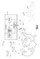
- FIG. 2 is a simplified schematic representation of an example system for providing a recommended route to a vehicle based on vehicle data collected from a plurality of other vehicles;
- FIG. 3 is a simplified schematic representation of a vehicle equipped with an example vehicle module suitable for use with the system of FIG. 2 ;
- FIG. 4 is a simplified schematic representation of an example data storage system suitable for use with the system of FIG. 2 ;
- FIG. 5 is a simplified schematic representation of an example processor suitable for use with the system of FIG. 2 ;
- FIG. 6A is a flow chart that illustrates an example calculation process for determining a recommended route for a requesting vehicle
- FIG. 6B is a flow chart that illustrates another example the calculation process of FIG. 5A ;
- FIG. 7 is a schematic representation of an example communication system suitable for use with the system of FIG. 2 ;
- FIG. 8 is a flow chart that illustrates an example method for providing a recommended route to a vehicle based on vehicle data collected from a plurality of other vehicles.
- FIG. 1 a brief discussion and overview is provided to describe an exemplary system 100 whose overall architecture, setup and operation, as well as individual components are generally known in the art but which may be modified in accordance with the teachings discussed in detail below to be compatible for use with the present method.
- the system and method taught herein will be discussed in detail after this brief overview of system 100 .
- System 100 generally includes a vehicle 102 , a wireless carrier system 104 , a land network 106 and a call center.
- Vehicle 102 is preferably a mobile vehicle such as a motorcycle, car, truck, recreational vehicle (RV), boat, plane, etc., and is equipped with suitable hardware and software that enables it to communicate over system 100 .
- vehicle hardware 110 is shown generally in FIG. 1 including a telematics unit 114 , a microphone 116 , a speaker 118 and buttons and/or controls 120 connected to the telematics unit 114 .
- Operatively coupled to the telematics unit 114 is a network connection or vehicle bus 122 .
- Suitable network connections include a controller area network (CAN), a media oriented system transfer (MOST), a local interconnection network (LIN), an Ethernet, and other appropriate connections such as those that conform with known ISO, SAE, and IEEE standards and specifications, to name a few.
- CAN controller area network
- MOST media oriented system transfer
- LIN local interconnection network
- Ethernet Ethernet
- other appropriate connections such as those that conform with known ISO, SAE, and IEEE standards and specifications, to name a few.
- the telematics unit 114 is an onboard device that provides a variety of services through its communication with the call center 108 , and generally includes an electronic processing device 128 , one or more types of electronic memory 130 , a cellular chipset/component 124 , a wireless modem 126 , a dual antenna 160 and a navigation unit containing a GPS chipset/component 132 .
- the wireless modem 126 is comprised of a computer program and/or set of software routines executing within electronic processing device 128 .
- the telematics unit 114 provides too many services to list them all, but several examples include: turn-by-turn directions and other navigation-related services provided in conjunction with the GPS based chipset/component 132 ; airbag deployment notification and other emergency or roadside assistance-related services provided in connection with various crash and or collision sensor interface modules 156 and sensors 158 located throughout the vehicle.
- Infotainment-related services where music, Web pages, movies, television programs, videogames and/or other content is downloaded by an infotainment center 136 operatively connected to the telematics unit 114 via vehicle bus 122 and audio bus 112 .
- downloaded content is stored for current or later playback.
- telematics unit 114 is by no means an exhaustive list of all the capabilities of telematics unit 114 , as should be appreciated by those skilled in the art, but are simply an illustration of some of the services that the telematics unit is capable of offering. It is anticipated that telematics unit 114 will include a number of known components in addition to those listed above.
- Vehicle communications preferably use radio transmissions to establish a voice channel with wireless carrier system 104 so that both voice and data transmissions can be sent and received over the voice channel.
- Vehicle communications are enabled via the cellular chipset/component 124 for voice communications and a wireless modem 126 for data transmission.
- wireless modem 126 applies some type of encoding or modulation to convert the digital data so that it can communicate through a vocoder or speech codec incorporated in the cellular chipset/component 124 . Any suitable encoding or modulation technique that provides an acceptable data rate and bit error can be used with the present method.
- Dual mode antenna 160 services the GPS chipset/component and the cellular chipset/component.
- Microphone 116 provides the driver or other vehicle occupant with a means for inputting verbal or other auditory commands, and can be equipped with an embedded voice processing unit utilizing a human/machine interface (HMI) technology known in the art.
- speaker 118 provides verbal output to the vehicle occupants and can be either a stand-alone speaker specifically dedicated for use with the telematics unit 114 or can be part of a vehicle audio component 154 .
- microphone 116 and speaker 118 enable vehicle hardware 110 and call center 108 to communicate with the occupants through audible speech.
- the vehicle hardware also includes one or more buttons or controls 120 for enabling a vehicle occupant to activate or engage one or more of the vehicle hardware components 110 .
- one of the buttons 120 can be an electronic pushbutton used to initiate voice communication with call center 108 (whether it be a live advisor 148 or an automated call response system).
- one of the buttons 120 can be used to initiate emergency services.
- the audio component 154 is operatively connected to the vehicle bus 122 and the audio bus 112 .
- the audio component 154 receives analog information, rendering it as sound, via the audio bus 112 .
- Digital information is received via the vehicle bus 122 .
- the audio component 154 provides AM and FM radio, CD, DVD, and multimedia functionality independent of the infotainment center 136 .
- Audio component 154 may contain a speaker system, or may utilize speaker 118 via arbitration on vehicle bus 122 and/or audio bus 112 .
- the vehicle crash and/or collision detection sensor interface 156 are operatively connected to the vehicle bus 122 .
- the crash sensors 158 provide information to the telematics unit via the crash and/or collision detection sensor interface 156 regarding the severity of a vehicle collision, such as the angle of impact and the amount of force sustained.
- Vehicle sensors 162 connected to various sensor interface modules 134 are operatively connected to the vehicle bus 122 .
- vehicle sensors include but are not limited to gyroscopes, accelerometers, magnetometers, emission detection and/or control sensors, and the like.
- Example sensor interface modules 134 include powertrain control, climate control, and body control, to name but a few.
- Wireless carrier system 104 is preferably a cellular telephone system or any other suitable wireless system that transmits signals between the vehicle hardware 110 and land network 106 .
- wireless carrier system 104 includes one or more cell towers 138 , base stations and/or mobile switching centers (MSCs) 140 , as well as any other networking components required to connect the wireless carrier system 104 with land network 106 .
- MSCs mobile switching centers
- various cell tower/based station/MSC arrangements are possible and could be used with wireless carrier system 104 .
- a base station and a cell tower could be co-located at the same site or they could be remotely located, and a single base station could be coupled to various cell towers or various base stations could be coupled with a single MSC, to list but a few of the possible arrangements.
- a speech codec or vocoder is incorporated in one or more of the base stations, but depending on the particular architecture of the wireless network, it could be incorporated within a Mobile Switching Center or some other network components as well.
- Land network 106 can be a conventional land-based telecommunications network that is connected to one or more landline telephones and connects wireless carrier system 104 to call center 108 .
- land network 106 can include a public switched telephone network (PSTN) and/or an Internet protocol (IP) network, as is appreciated by those skilled in the art.
- PSTN public switched telephone network
- IP Internet protocol
- one or more segments of the land network 106 can be implemented in the form of a standard wired network, a fiber or other optical network, a cable network, other wireless networks such as wireless local networks (WLANs) or networks providing broadband wireless access (BWA), or any combination thereof.
- WLANs wireless local networks
- BWA broadband wireless access
- Call center 108 is designed to provide the vehicle hardware 110 with a number of different system back-end functions and, according to the example shown here, generally includes one or more switches 142 , servers 144 , databases 146 , live advisors 148 , as well as a variety of other telecommunication and computer equipment 150 that is known to those skilled in the art. These various call center components are preferably coupled to one another via a network connection or bus 152 , such as the one previously described in connection with the vehicle hardware 110 .
- Switch 142 which can be a private branch exchange (PBX) switch, routes incoming signals so that voice transmissions are usually sent to either the live advisor 148 or an automated response system, and data transmissions are passed on to a modem or other piece of computer equipment 150 for demodulation and further signal processing.
- the computer equipment 150 preferably includes an encoder, as previously explained, and can be connected to various devices such as a server 144 and database 146 .
- database 146 could be designed to store subscriber profile records, subscriber behavioral patterns, or any other pertinent subscriber information.
- the call center 108 can be any central or remote facility, manned or unmanned, mobile or fixed, to or from which it is desirable to exchange voice and data.
- the system includes a plurality of vehicle modules that are embedded or otherwise attached to a respective one of a plurality of vehicles.
- Each vehicle module is configured to collect vehicle data concerning the respective vehicle with which it is associated.
- the vehicle data may include, without limitation, geographic information, fuel consumption information, vehicle operational conditions, vehicle specification information (i.e., make, model and configuration) and information regarding external conditions such as, but not limited to, time of day information, date information and prevailing temperature information.
- Each vehicle module is further configured to transmit the vehicle data to a data center.
- the data center may be located remotely from the plurality of vehicle modules and is configured to receive, store and compile the vehicle data from the plurality of vehicles. In this manner, fuel consumption information may be stored for a very large number of vehicles.
- the compiled vehicle data makes possible the calculation of fuel consumption rates for a variety of differently configured vehicles along specific route segments at varying times, dates and temperatures.
- the data center is further configured to receive an interrogation signal initiated by a requesting vehicle.
- the term “requesting vehicle” refers to the vehicle sending the interrogation signal and seeking the recommended route, or seeking some other calculated result, from the data center.
- the data center is further configured to calculate the recommended route in response to the interrogation signal initiated by the requesting vehicle.
- the interrogation signal may be an electronic or voice communication and may be received directly from the requesting vehicle or may be relayed to the data center through a human advisor or attendant.
- the data center may determine the recommended route utilizing the compiled vehicle data.
- the term “compiled vehicle data” refers to the compilation of vehicle data received from each vehicle module over time.
- the data center may utilize a subset of the compiled vehicle data to calculate the recommended route. For example, if the requesting vehicle is equipped with a hybrid electric power train, the data center may calculate the recommended route using only a subset of the compiled vehicle data that is derived from other vehicles having a hybrid electric power train.
- the compiled vehicle data may be filtered based on other characteristics in common between the requesting vehicle and the plurality of vehicles providing the vehicle data.
- the data center may calculate the recommended route using only compiled vehicle data provided by vehicles that are substantially equivalent to the requesting vehicle (i.e., vehicles of the same make, model, and configuration as the requesting vehicle, or corporate twins of the requesting vehicle). In still other example, driver habits may be considered. Such filtering of compiled vehicle data allows the data center to more accurately assess anticipated fuel consumption by the requesting vehicle.
- the data center may also consider various road data, such as, but not limited to, roads requiring the payment of a toll, and roads that are undergoing construction. Road data of this sort permits the data center to calculate the least expensive route for the vehicle to travel.
- the data center may be configured to transmit the recommended route to the requesting vehicle and the vehicle module may be configured to receive the recommended route from the data center.
- the data center may transmit the compiled vehicle data itself, or some subset thereof, to the requesting vehicle.
- the recommended route calculation is undertaken by a processor onboard the requesting vehicle.
- the system and method may present the vehicle operator with the greenest route.
- greenest route refers to the route that will require the vehicle to consume the least amount of fuel as it travels between the starting point and the ending point.
- FIG. 2 illustrates a simplified example of a system 10 for providing information to a vehicle.
- system 10 may comprise exemplary system 100 , described above.
- System 10 includes a plurality of vehicle modules 12 (see FIG. 3 ) configured for attachment to a respective one of a plurality of vehicles 14 .
- the plurality of vehicles 14 are dispersed throughout a geographic region, e.g., throughout the continental United States. While FIG. 2 depicts each vehicle 14 as an automobile, it should be understood that the systems and methods disclosed herein are compatible with all types of vehicles including, but not limited to aircraft and water craft.
- System 10 further includes a data center 16 located remotely from, and in communication with, each vehicle module 12 .
- data center 16 may comprise call center 108 , described above.
- vehicle module 12 is configured to transmit signals to, and to receive signals from, data center 16 .
- Data center 16 includes a data storage system 18 , a processor 20 , and a communication system 22 .
- data center 16 may comprise a plurality of the data storage systems 18 , the processors 20 and the communication systems 22 .
- data center 16 is depicted as a stand-alone, single purpose facility dedicated to administering the systems and methods disclosed herein. It should be understood that data center 16 may, alternatively, be spread throughout a plurality of buildings or structures which may be either collocated with one another or which may be remote from one another and interconnected through local or wide area networks or otherwise interconnected. Furthermore, data center 16 need not be housed in a single purpose facility but may be housed in a multi-purpose facility.
- Vehicle module 12 is configured to engage in communications with data center 16 without involvement by the vehicle operator. In some examples, vehicle module 12 is configured to automatically transmit vehicle data 24 to data center 16 at regular intervals. In other examples, vehicle module 12 may constantly transmit vehicle data 24 whenever vehicle 14 is being operated. In still other examples, vehicle module 12 may transmit vehicle data 24 in response to a request for such data transmitted by data center 16 .
- Vehicle data 24 comprises information about the respective vehicle 14 's operational performance.
- Data center 16 receives vehicle data 24 from each vehicle module 12 and stores vehicle data 24 as compiled vehicle data 26 . Compiled vehicle data 26 accumulates over time as each vehicle module 12 continues to transmit vehicle data 24 to data center 16 . In this manner, data center 16 can accumulate a large data base of information concerning vehicle operations and performance.
- a requesting vehicle 28 is depicted as both transmitting an interrogation signal 29 to, and receiving a response signal 30 , from data center 16 .
- data center 16 utilizes compiled vehicle data 26 to calculate a recommended route 32 (e.g. the greenest route) which is, in turn, transmitted to requesting vehicle 28 via response signal 30 .
- a recommended route 32 e.g. the greenest route
- an individual vehicle such as requesting vehicle 28 can submit a request for information relating to its specific needs and data center 16 can provide a response based on the accumulated experiences of other vehicles.
- FIG. 3 illustrates an exemplary vehicle 14 equipped with an example of vehicle module 12 .
- vehicle module 12 may comprise telematics unit 114 , described above.
- vehicle module 12 includes a global positioning system (GPS) component 34 capable of interacting with GPS satellites 36 (see FIG. 2 ) orbiting the earth.
- GPS component 34 may comprise GPS chipset/component 132 , described above.
- GPS satellites 36 regularly transmit GPS signals 37 towards the earth.
- GPS component 34 is configured to receive GPS signals 37 and to determine the location of vehicle module 12 on the surface of the earth. This geographic information is correlated with mapping data to enable GPS component 34 to determine the position of vehicle module 12 with respect to known roads.
- Vehicle module 12 further includes a vehicle communication system 38 configured to communicate with data center 16 .
- vehicle communication system 38 comprises a cellular telecommunications system.
- vehicle communication system 38 may comprise cellular chip set/component 124 , described above.
- communication devices other than cellular telecommunications may be employed.
- an RF transceiver, a WiFi communications device, a satellite communications device, a dedicated short range communications device, or any other type of communications device effective to communicate with data center 16 may be employed without departing from the teachings of the present system.
- an intermediate communications hub may be employed to receive vehicle data 24 from vehicle module 12 .
- the intermediate communications hub may include a vehicle dealership that operates a WiFi network to communicate with vehicle module 12 .
- the dealership may download vehicle data 24 from the vehicle during the performance of a routine diagnostics examination of vehicle 14 .
- Vehicle module 12 further includes a data accumulator 40 which may comprise a hard drive, or any other device configured to store vehicle data 24 .
- data accumulator 40 may comprise electronic memory 130 , described above.
- Data accumulator 40 may temporarily accumulate vehicle data 24 as accumulated vehicle data 41 and may be employed in examples of vehicle module 12 wherein vehicle data 24 is periodically transmitted to data center 16 . In examples of vehicle module 12 wherein vehicle data 24 is continuously transmitted to data center 16 , data accumulator 40 may be unnecessary.
- Vehicle module 12 further comprises a vehicle processor 42 .
- Vehicle processor 42 may comprise any type of computer, microprocessor or controller. In some examples, vehicle processor 42 may comprise electronic processing device 128 , describe above. Vehicle processor 42 is in communication with GPS component 34 , vehicle communication system 38 and data accumulator 40 and is configured to control the collection, storage and transmission of vehicle data 24 .
- Vehicle processor 42 is also in communication with other vehicle components including, but not limited to vehicle CPU 44 , display component 46 , and user interface 48 .
- Vehicle CPU 44 may collect vehicle information such as distance traveled and fuel consumed by vehicle 14 .
- User interface 48 is configured to allow the driver of vehicle 14 to initiate interrogation signal 29 which may be an electronic signal sent directly to data center 16 or which may be a voice communication to an attendant in communication with, or located at, data center 16 .
- user interface 48 may comprise microphone 116 and buttons/controls 120 , described above.
- Vehicle processor 42 may receive the distance and fuel consumption information from vehicle CPU 44 . Vehicle processor 42 may further correlate the distance and fuel consumption information with geographic information to determine vehicle 14 's fuel consumption rates along specific route segments.
- Vehicle processor 42 may direct that such data be transmitted to data center 16 or be stored in data accumulator 40 as accumulated data 41 for later transmission to data center 16 . In other examples, vehicle processor 42 may simply control the storage and transmission of geographic information and fuel consumption information, with the correlation of such information occurring at data center 16 .
- FIG. 4 illustrates an example of data storage system 18 .
- Data storage system 18 may comprise a hard drive, a plurality of hard drives, or any other device, mechanism, media, or system configured to store vehicle data 24 .
- data storage system 18 may comprise databases 146 , described above.
- Data storage system 18 is in communication with processor 20 and with communication system 22 .
- Data storage system 18 may be configured to contain compiled vehicle data 26 .
- Compiled vehicle data 26 may include geographic information, fuel consumption information, fuel consumption rate information, time of day information, date information, and temperature information.
- Compiled vehicle data 26 may further include vehicle specification information for each vehicle 14 such as, but not limited to, make, model, engine size, engine type, power train configuration, gross vehicle weight, body style, and vehicle options.
- Data storage system 18 may further store road data 50 .
- Road data 50 may include, but is not limited to, information relating to the location of toll roads, toll bridges toll tunnels and toll booths. Road data 50 and may also include information such as, but not limited to road construction schedules, weather phenomena, fuel station locations, fuel cost and any other information which may have an impact on fuel consumption and the costs associated therewith. Compiled vehicle data 26 and road data 50 are stored in data storage system 18 until needed by processor 20 .
- FIG. 5 illustrates an example of processor 20 .
- Processor 20 may comprise any computer, microprocessor, or controller. In some examples, processor 20 may comprise servers 144 , describe above.
- Processor 20 is in communication with data storage system 18 and with communication system 22 and is configured to coordinate the activities of those components.
- Processor 20 controls the collection of vehicle data 24 and the storage of compiled vehicle data 26 .
- Processor 20 may also be configured to obtain road data 50 from external sources such as, but not limited to, information available over the internet, and to direct the storage of road data in data storage system 18 .
- Processor may further be configured to respond to interrogation signal 29 from requesting vehicle 28 and to calculate recommended route 32 .
- processor 20 receives an incoming signal.
- processor 20 determines whether the incoming signal is vehicle data 24 . If the incoming signal is vehicle data 24 , then at block 56 , processor 20 forwards the vehicle data 24 to the data storage system 18 for storage as compiled vehicle data 26 . If the incoming signal is not vehicle data 24 , then at block 58 , the processor 20 determines whether the incoming signal is interrogation signal 29 . If the incoming signal is not interrogation signal 29 , then the incoming signal may be discarded and processor 20 returns to block 52 to await the next incoming signal.
- processor 20 retrieves compiled vehicle data 26 from data storage system 18 .
- processor 20 calculates the recommended route 32 .
- processor 20 controls communication system 22 to transmit recommended route 32 to requesting vehicle 28 and then returns to block 52 to await the next incoming signal.
- FIGS. 6A and 6B are flow charts illustrating examples of alternate processes undertaken by processor 20 when responding to interrogation signal 29 .
- FIG. 6A illustrates an example of a process for determining the recommended route between a starting point and an ending point.
- processor 20 determines the specifications for requesting vehicle 28 . For example, processor 20 may determine that requesting vehicle 28 is a particular make and model vehicle having a hybrid electric power train.
- processor 20 may disregard a portion of compiled vehicle data 26 collected from dissimilar vehicles.
- processor 20 may determine the prevailing external conditions such as the time, date and local weather conditions at the location from which interrogation signal 29 was transmitted.
- processor 20 may disregard a portion of compiled vehicle data 26 collected from vehicles at differing times, dates and weather conditions.
- processor 20 may correlate the remaining compiled vehicle data 26 for similar vehicles collected under similar time, date and weather conditions, on the one hand, with geographic information, on the other hand. This correlation permits processor 20 to determine historical fuel consumption rates for similar vehicles under similar conditions on roads disposed between the starting point and the ending point.
- processor 20 can determine the recommended route.
- processor 20 can control the communication system 22 to transmit the recommended route to requesting vehicle 28 .
- the recommended route may be determined utilizing all of the compiled vehicle data 26 .
- compiled vehicle data 26 from dissimilar vehicles may be disregarded but compiled vehicle data 26 collected under dissimilar conditions may be considered.
- compiled vehicle data 26 collected under dissimilar conditions may be disregarded, but compiled vehicle data 26 from dissimilar vehicles may be considered. All permutations and combinations of utilizing the compiled vehicle data are possible.
- FIG. 6B illustrates an alternate example of the process depicted in FIG. 6A .
- the first four steps of the process, shown at blocks 80 through 86 are identical to the steps depicted at blocks 66 through 72 , and the associated description is incorporated here by reference.
- processor 20 directs communication system 22 to transmit the remaining compiled vehicle data 26 to requesting vehicle 28 .
- This example requires vehicle processor 42 to use compiled vehicle data 26 to determine the recommended route.
- compiled vehicle data 26 may be communicated to the embedded navigation system for determination of the recommended route.
- Recommended route 32 may be displayed to an operator in requesting vehicle 28 on display component 46 .
- Display component 46 may be an embedded navigation system, a vehicle radio display, or some other display.
- recommended route 32 may be communicated to an operator in requesting vehicle 28 through audible instructions broadcast through radio speakers, through a dedicated set of loudspeakers, or through some other means effective to communicate audible instructions.
- FIG. 7 is a schematic illustration of communication system 22 .
- Communication system 22 includes an antenna 51 for receiving and transmitting cellular signals.
- Communication system 22 is in communication with data storage system 18 and with processor 20 .
- Communication system 22 is configured to forward vehicle data 24 received from the plurality of vehicle modules 12 to data storage system 18 .
- Any transceiver configured to transmit and receive signals may be employed with communication system 22 .
- a separate transmitter and receiver may be employed.
- Communication system 22 may comprise a cellular telecommunication system or may comprise any type of transceiver configured to both transmit and receive RF signals.
- microwave communications, satellite communications, and WiFi communication systems may be employed.
- FIG. 8 illustrates an exemplary method for providing information to requesting vehicle 28 .
- vehicle data 24 is received at data center 16 .
- the vehicle data 24 is stored as compiled vehicle data 26 . These first two steps may repeat themselves a plurality of times to provide a constantly increasing and perpetually updated data base of vehicle information.
- data center 16 receives interrogation signal 29 from requesting vehicle 28 .
- data center 16 calculates recommended route 32 .
- recommended route 32 is transmitted to requesting vehicle 28 .
- recommended route 32 has been discussed herein as being based, in part, on fuel consumption, it should be understood that recommended route 32 may comprise any result calculable from data collected from a plurality of vehicles and may be based on any factor or consideration or any combination of factors and considerations including, in addition to, or other than, fuel consumption.
- requesting vehicle 28 may request recommended route 32 between requesting vehicle 28 's current location and a desired destination.
- processor 20 may first determine/identify all or multiple routes that lead from requesting vehicle 28 's current location to the desired location. Processor 20 may make this determination by utilizing methods currently employed in conventional navigation systems.
- processor 20 may retrieve and utilize compiled vehicle data 26 to determine the amount of fuel consumed by the plurality of vehicles 14 as they traveled along each of the possible routes. In some examples, processor may retrieve only a subset of compiled vehicle data 26 to determine the amount of fuel consumed along each of the possible routes. For example, Processor 20 may filter out data derived from dissimilar vehicles and/or data collected at differing times of day and year and may also filter out data collected under dissimilar weather conditions when determining the fuel consumed along the possible routes.
- processor 20 may evaluate each segment of road that comprises each of the possible routes.
- Each individual segment of road (in this context, a segment may include, but need not be limited to, a portion of road between two intersections) can have a fuel consumption value associated with it.
- the recommended route 32 may comprise a compilation of road segments that add up to the lowest amount of fuel historically consumed.
- processor 20 may forward it to requesting vehicle 28 using communication system 22 .
Abstract
Description
Claims (12)
Priority Applications (1)
| Application Number | Priority Date | Filing Date | Title |
|---|---|---|---|
| US12/490,746 US8321125B2 (en) | 2009-06-24 | 2009-06-24 | System and method for providing route guidance to a requesting vehicle |
Applications Claiming Priority (1)
| Application Number | Priority Date | Filing Date | Title |
|---|---|---|---|
| US12/490,746 US8321125B2 (en) | 2009-06-24 | 2009-06-24 | System and method for providing route guidance to a requesting vehicle |
Publications (2)
| Publication Number | Publication Date |
|---|---|
| US20100332113A1 US20100332113A1 (en) | 2010-12-30 |
| US8321125B2 true US8321125B2 (en) | 2012-11-27 |
Family
ID=43381653
Family Applications (1)
| Application Number | Title | Priority Date | Filing Date |
|---|---|---|---|
| US12/490,746 Active 2031-03-14 US8321125B2 (en) | 2009-06-24 | 2009-06-24 | System and method for providing route guidance to a requesting vehicle |
Country Status (1)
| Country | Link |
|---|---|
| US (1) | US8321125B2 (en) |
Cited By (10)
| Publication number | Priority date | Publication date | Assignee | Title |
|---|---|---|---|---|
| US20120232783A1 (en) * | 2011-03-08 | 2012-09-13 | Navteq North America, Llc | Energy Consumption Profiling |
| US20130096826A1 (en) * | 2011-10-17 | 2013-04-18 | Roman Krzanowski | Route selection |
| US20130245870A1 (en) * | 2010-03-30 | 2013-09-19 | Honda Motor Co., Ltd. | Minimum Energy Route For A Motor Vehicle |
| US8935090B2 (en) | 2010-03-30 | 2015-01-13 | Honda Motor Co., Ltd. | Energy mapping systems |
| US9068848B2 (en) * | 2010-07-21 | 2015-06-30 | Harman Becker Automotive Systems Gmbh | Providing cost information associated with intersections |
| US9672738B1 (en) | 2016-02-02 | 2017-06-06 | Allstate Insurance Company | Designing preferred vehicle routes based on driving scores from other vehicles |
| US10650621B1 (en) | 2016-09-13 | 2020-05-12 | Iocurrents, Inc. | Interfacing with a vehicular controller area network |
| US10755575B2 (en) | 2018-08-30 | 2020-08-25 | Cisco Technology, Inc. | Raw sensor data sharing for enhanced fleet-wide environmental awareness and safety |
| US11162799B2 (en) * | 2015-05-28 | 2021-11-02 | Google Llc | Dynamically integrating offline and online data in a geographic application |
| RU2770938C1 (en) * | 2021-04-25 | 2022-04-25 | Николай Анатольевич Грязнов | Communication and navigation system for controlling traffic |
Families Citing this family (10)
| Publication number | Priority date | Publication date | Assignee | Title |
|---|---|---|---|---|
| GB2484085B (en) * | 2010-09-28 | 2014-05-07 | Cassidian Ltd | Telecommunications network routing |
| US20130054023A1 (en) | 2011-08-30 | 2013-02-28 | 5D Robotics, Inc. | Asynchronous Data Stream Framework |
| US8775059B2 (en) * | 2011-10-26 | 2014-07-08 | Right There Ware LLC | Method and system for fleet navigation, dispatching and multi-vehicle, multi-destination routing |
| US8868332B2 (en) * | 2011-10-26 | 2014-10-21 | Right There Ware LLC | Method and system for navigation using bounded geograhic regions |
| US9108640B2 (en) | 2012-01-31 | 2015-08-18 | Google Inc. | Systems and methods for monitoring and reporting road quality |
| CN102735255A (en) * | 2012-06-04 | 2012-10-17 | 苏州天泽信息科技有限公司 | Vehicle oil consumption monitoring system |
| US9448073B2 (en) | 2013-06-10 | 2016-09-20 | Google Inc. | System and method for assessing road quality using data collected from a mobile device |
| US10311656B2 (en) * | 2015-10-13 | 2019-06-04 | Ford Global Technologies, Llc | Vehicle processor and method for tracking and reporting vehicle use and associated fuel cost |
| DE102016204522A1 (en) * | 2016-03-18 | 2017-09-21 | Bayerische Motoren Werke Aktiengesellschaft | Method for operating a navigation system |
| SE540070C2 (en) | 2016-06-29 | 2018-03-13 | Scania Cv Ab | Method and system for determining a suitable route for a vehicle |
Citations (25)
| Publication number | Priority date | Publication date | Assignee | Title |
|---|---|---|---|---|
| US6424912B1 (en) | 2001-11-09 | 2002-07-23 | General Motors Corporation | Method for providing vehicle navigation instructions |
| US6427119B1 (en) | 2001-04-16 | 2002-07-30 | General Motors Corporation | Method and system for providing multiple entry points to a vehicle navigation route |
| US6507785B1 (en) | 2001-09-21 | 2003-01-14 | General Motors Corportion | Method and system for detecting and correcting off route navigation for server based route guidance systems |
| US6542818B1 (en) | 2002-01-29 | 2003-04-01 | General Motors Corporation | Method and system for real-time recording and uploading of vehicle routes for routing assistance and traffic reporting |
| US6587785B2 (en) | 2001-09-21 | 2003-07-01 | General Motors Corporation | Method and system for mobile vehicle re-routing |
| US6625538B2 (en) | 2001-11-01 | 2003-09-23 | General Motors Corporation | Method and system for reducing maneuver proximity diameter for a waypoint navigation system |
| US6640186B2 (en) | 2001-04-16 | 2003-10-28 | General Motors Corporation | Method and system for generating a list of maneuvers for navigation of a vehicle |
| US6665610B1 (en) | 2001-11-09 | 2003-12-16 | General Motors Corporation | Method for providing vehicle navigation instructions |
| US6701251B2 (en) | 2001-04-18 | 2004-03-02 | General Motors Corporation | Method and system for providing multiple beginning maneuvers for navigation of a vehicle |
| US6708110B2 (en) | 2001-11-01 | 2004-03-16 | General Motors Corporation | Method of providing vehicle instructions to a non-navigable point of interest |
| US7062379B2 (en) | 2002-07-09 | 2006-06-13 | General Motors Corporation | Receiving traffic update information and reroute information in a mobile vehicle |
| US20060136122A1 (en) | 2004-12-16 | 2006-06-22 | General Motors Corporation | Method to dynamically select a routing service option |
| US20060253248A1 (en) | 2005-04-14 | 2006-11-09 | General Motors Corporation | Method for determining vehicle location including road surface data |
| US20060271283A1 (en) | 2005-05-26 | 2006-11-30 | General Motors Corporation | System and method for zone based initial route guidance within a telematics equipped mobile vehicle |
| US7155335B2 (en) | 2003-08-06 | 2006-12-26 | General Motors Corporation | Satellite radio real time traffic updates |
| US20060291633A1 (en) | 2005-06-06 | 2006-12-28 | General Motors Corporation | Method and system for determining traffic information traffic profiles |
| US20070027614A1 (en) | 2005-08-01 | 2007-02-01 | General Motors Corporation | Method and system for linked vehicle navigation |
| US20070112509A1 (en) * | 2003-12-04 | 2007-05-17 | Navitime Japan Co., Ltd. | Route guide data creation device, route guide data creation method, and route guide distribution device |
| US20080004790A1 (en) | 2006-06-30 | 2008-01-03 | General Motors Corporation | Methods and system for providing routing assistance to a vehicle |
| US20080010011A1 (en) | 2006-07-07 | 2008-01-10 | General Motors Corporation | Method for storing off-board navigation destination locations |
| US20080046174A1 (en) | 2006-07-26 | 2008-02-21 | General Motors Corporation | Route-matching method for use with vehicle navigation systems |
| US20080114533A1 (en) | 2006-11-09 | 2008-05-15 | General Motors Corporation | Method of providing a navigational route for a vehicle navigation system |
| US20080306682A1 (en) | 2007-06-05 | 2008-12-11 | General Motors Corporation | System serving a remotely accessible page and method for requesting navigation related information |
| US7499798B2 (en) | 2005-02-23 | 2009-03-03 | General Motors Corporation | Method for transferring routes between navigational devices |
| US20100049397A1 (en) * | 2008-08-22 | 2010-02-25 | Garmin Ltd. | Fuel efficient routing |
-
2009
- 2009-06-24 US US12/490,746 patent/US8321125B2/en active Active
Patent Citations (26)
| Publication number | Priority date | Publication date | Assignee | Title |
|---|---|---|---|---|
| US6640186B2 (en) | 2001-04-16 | 2003-10-28 | General Motors Corporation | Method and system for generating a list of maneuvers for navigation of a vehicle |
| US6427119B1 (en) | 2001-04-16 | 2002-07-30 | General Motors Corporation | Method and system for providing multiple entry points to a vehicle navigation route |
| US6701251B2 (en) | 2001-04-18 | 2004-03-02 | General Motors Corporation | Method and system for providing multiple beginning maneuvers for navigation of a vehicle |
| US6507785B1 (en) | 2001-09-21 | 2003-01-14 | General Motors Corportion | Method and system for detecting and correcting off route navigation for server based route guidance systems |
| US6587785B2 (en) | 2001-09-21 | 2003-07-01 | General Motors Corporation | Method and system for mobile vehicle re-routing |
| US6708110B2 (en) | 2001-11-01 | 2004-03-16 | General Motors Corporation | Method of providing vehicle instructions to a non-navigable point of interest |
| US6625538B2 (en) | 2001-11-01 | 2003-09-23 | General Motors Corporation | Method and system for reducing maneuver proximity diameter for a waypoint navigation system |
| US6665610B1 (en) | 2001-11-09 | 2003-12-16 | General Motors Corporation | Method for providing vehicle navigation instructions |
| US6424912B1 (en) | 2001-11-09 | 2002-07-23 | General Motors Corporation | Method for providing vehicle navigation instructions |
| US6542818B1 (en) | 2002-01-29 | 2003-04-01 | General Motors Corporation | Method and system for real-time recording and uploading of vehicle routes for routing assistance and traffic reporting |
| US7062379B2 (en) | 2002-07-09 | 2006-06-13 | General Motors Corporation | Receiving traffic update information and reroute information in a mobile vehicle |
| US7174253B2 (en) | 2002-07-09 | 2007-02-06 | General Motors Corporation | Receiving traffic update information and reroute information in a mobile vehicle |
| US7155335B2 (en) | 2003-08-06 | 2006-12-26 | General Motors Corporation | Satellite radio real time traffic updates |
| US20070112509A1 (en) * | 2003-12-04 | 2007-05-17 | Navitime Japan Co., Ltd. | Route guide data creation device, route guide data creation method, and route guide distribution device |
| US20060136122A1 (en) | 2004-12-16 | 2006-06-22 | General Motors Corporation | Method to dynamically select a routing service option |
| US7499798B2 (en) | 2005-02-23 | 2009-03-03 | General Motors Corporation | Method for transferring routes between navigational devices |
| US20060253248A1 (en) | 2005-04-14 | 2006-11-09 | General Motors Corporation | Method for determining vehicle location including road surface data |
| US20060271283A1 (en) | 2005-05-26 | 2006-11-30 | General Motors Corporation | System and method for zone based initial route guidance within a telematics equipped mobile vehicle |
| US20060291633A1 (en) | 2005-06-06 | 2006-12-28 | General Motors Corporation | Method and system for determining traffic information traffic profiles |
| US20070027614A1 (en) | 2005-08-01 | 2007-02-01 | General Motors Corporation | Method and system for linked vehicle navigation |
| US20080004790A1 (en) | 2006-06-30 | 2008-01-03 | General Motors Corporation | Methods and system for providing routing assistance to a vehicle |
| US20080010011A1 (en) | 2006-07-07 | 2008-01-10 | General Motors Corporation | Method for storing off-board navigation destination locations |
| US20080046174A1 (en) | 2006-07-26 | 2008-02-21 | General Motors Corporation | Route-matching method for use with vehicle navigation systems |
| US20080114533A1 (en) | 2006-11-09 | 2008-05-15 | General Motors Corporation | Method of providing a navigational route for a vehicle navigation system |
| US20080306682A1 (en) | 2007-06-05 | 2008-12-11 | General Motors Corporation | System serving a remotely accessible page and method for requesting navigation related information |
| US20100049397A1 (en) * | 2008-08-22 | 2010-02-25 | Garmin Ltd. | Fuel efficient routing |
Non-Patent Citations (4)
| Title |
|---|
| Bicego, J., et al., "Method and System for Automatically Updating Traffic Incident Data for In-Vehicle Navigation," filed on Mar. 31, 2008, U.S. Appl. No. 12/059,647. |
| Johnson, R.A. "Method and System to Calculate Historical Traffic Data," filed on Jun. 30, 2008, U.S. Appl. No. 12/165,183. |
| Johnson, R.A. et al., "Method and System of Using Turn by Turn Server Based Reroutes Data to Improve an Navigation User Interface," filed on Jun. 30, 2008, U.S. Appl. No. 12/165,159. |
| Tengler, S. et al., "System and Method for Providing Multiple Portions or a Route in a Telematics System," filed on Jun. 30, 2008, U.S. Appl. No. 12/165,311. |
Cited By (18)
| Publication number | Priority date | Publication date | Assignee | Title |
|---|---|---|---|---|
| US20130245870A1 (en) * | 2010-03-30 | 2013-09-19 | Honda Motor Co., Ltd. | Minimum Energy Route For A Motor Vehicle |
| US8935090B2 (en) | 2010-03-30 | 2015-01-13 | Honda Motor Co., Ltd. | Energy mapping systems |
| US9068848B2 (en) * | 2010-07-21 | 2015-06-30 | Harman Becker Automotive Systems Gmbh | Providing cost information associated with intersections |
| US8755993B2 (en) * | 2011-03-08 | 2014-06-17 | Navteq B.V. | Energy consumption profiling |
| US20120232783A1 (en) * | 2011-03-08 | 2012-09-13 | Navteq North America, Llc | Energy Consumption Profiling |
| US20130096826A1 (en) * | 2011-10-17 | 2013-04-18 | Roman Krzanowski | Route selection |
| US8768623B2 (en) * | 2011-10-17 | 2014-07-01 | Verizon Patent And Licensing Inc. | Route selection |
| US9261377B2 (en) | 2011-10-17 | 2016-02-16 | Verizon Patent And Licensing Inc. | Route selection |
| US11162799B2 (en) * | 2015-05-28 | 2021-11-02 | Google Llc | Dynamically integrating offline and online data in a geographic application |
| US9672738B1 (en) | 2016-02-02 | 2017-06-06 | Allstate Insurance Company | Designing preferred vehicle routes based on driving scores from other vehicles |
| US11037444B2 (en) | 2016-02-02 | 2021-06-15 | Allstate Insurance Company | Designing preferred vehicle routes based on driving scores from other vehicles |
| US10332397B2 (en) | 2016-02-02 | 2019-06-25 | Allstate Insurance Company | Preferred vehicle routes based on driving scores from other vehicles |
| US11735046B2 (en) | 2016-02-02 | 2023-08-22 | Allstate Insurance Company | Designing preferred vehicle routes based on driving scores from other vehicles |
| US10650621B1 (en) | 2016-09-13 | 2020-05-12 | Iocurrents, Inc. | Interfacing with a vehicular controller area network |
| US11232655B2 (en) | 2016-09-13 | 2022-01-25 | Iocurrents, Inc. | System and method for interfacing with a vehicular controller area network |
| US10755575B2 (en) | 2018-08-30 | 2020-08-25 | Cisco Technology, Inc. | Raw sensor data sharing for enhanced fleet-wide environmental awareness and safety |
| RU2770938C1 (en) * | 2021-04-25 | 2022-04-25 | Николай Анатольевич Грязнов | Communication and navigation system for controlling traffic |
| WO2022231467A1 (en) * | 2021-04-25 | 2022-11-03 | Николай Анатольевич ГРЯЗНОВ | Communication and navigation system for managing traffic flows |
Also Published As
| Publication number | Publication date |
|---|---|
| US20100332113A1 (en) | 2010-12-30 |
Similar Documents
| Publication | Publication Date | Title |
|---|---|---|
| US8321125B2 (en) | System and method for providing route guidance to a requesting vehicle | |
| US9552728B2 (en) | Route-based propulsion mode control for multimodal vehicles | |
| US8082095B2 (en) | Enhanced passenger pickup via telematics synchronization | |
| US11307043B2 (en) | Vehicle energy management | |
| US7672774B2 (en) | Method and system for determining traffic information traffic profiles | |
| US8155865B2 (en) | Method and system for automatically updating traffic incident data for in-vehicle navigation | |
| US8442759B2 (en) | System and method for providing multiple portions of a route in a telematics system | |
| US9759569B2 (en) | Apparatus and method for determining parking information | |
| US8050855B2 (en) | Method and system for transmitting data to a traffic information server | |
| CN102300152B (en) | Method of using vehicle location information with a wireless mobile device | |
| CN103106702B (en) | Based on the bus trip service system of cloud computing | |
| US20160104378A1 (en) | Method of determining an attribute of a parking structure | |
| US20100191403A1 (en) | System and method for communicating with a vehicle about then-current vehicle operating conditions using a telematics unit | |
| US20100292916A1 (en) | Navigation System For a Motor Vehicle | |
| US20120187916A1 (en) | Virtual Charge for Electric Vehicles | |
| US20130290199A1 (en) | Monitoring and Aiding User Compliance with Vehicle Use Agreements | |
| US9841288B2 (en) | Packaged tours with turn-by-turn navigation | |
| US20130275368A1 (en) | Maintaining Electrical Vehicle Recharging Station Data | |
| CN103377560A (en) | Road condition active forecasting method and apparatus based on vehicle terminal navigation | |
| US20200334920A1 (en) | Geo bounded dynamic data collection for road tolling and road usage monitoring | |
| CN103201776A (en) | Method of retrieving information for a motor vehicle | |
| US20090088973A1 (en) | Commuter Route Learning | |
| US9109910B2 (en) | Method and decreasing position error during turn-by-turn sessions | |
| US8645066B2 (en) | Variable corridor navigation | |
| US8805611B2 (en) | Neutral zones for navigation |
Legal Events
| Date | Code | Title | Description |
|---|---|---|---|
| AS | Assignment |
Owner name: GENERAL MOTORS CORPORATION, MICHIGAN Free format text: ASSIGNMENT OF ASSIGNORS INTEREST;ASSIGNORS:TENGLER, STEVEN C.;JOHNSON, RICHARD A.;WATKINS, GARY A.;AND OTHERS;REEL/FRAME:022869/0668 Effective date: 20090623 |
|
| AS | Assignment |
Owner name: MOTORS LIQUIDATION COMPANY, MICHIGAN Free format text: CHANGE OF NAME;ASSIGNOR:GENERAL MOTORS CORPORATION;REEL/FRAME:023129/0236 Effective date: 20090709 |
|
| AS | Assignment |
Owner name: UNITED STATES DEPARTMENT OF THE TREASURY, DISTRICT Free format text: SECURITY AGREEMENT;ASSIGNOR:GENERAL MOTORS COMPANY;REEL/FRAME:023155/0814 Effective date: 20090710 Owner name: GENERAL MOTORS COMPANY, MICHIGAN Free format text: ASSIGNMENT OF ASSIGNORS INTEREST;ASSIGNOR:MOTORS LIQUIDATION COMPANY;REEL/FRAME:023148/0248 Effective date: 20090710 Owner name: UAW RETIREE MEDICAL BENEFITS TRUST, MICHIGAN Free format text: SECURITY AGREEMENT;ASSIGNOR:GENERAL MOTORS COMPANY;REEL/FRAME:023155/0849 Effective date: 20090710 |
|
| AS | Assignment |
Owner name: GENERAL MOTORS LLC, MICHIGAN Free format text: CHANGE OF NAME;ASSIGNOR:GENERAL MOTORS COMPANY;REEL/FRAME:023504/0691 Effective date: 20091016 |
|
| AS | Assignment |
Owner name: GM GLOBAL TECHNOLOGY OPERATIONS, INC., MICHIGAN Free format text: RELEASE BY SECURED PARTY;ASSIGNOR:UNITED STATES DEPARTMENT OF THE TREASURY;REEL/FRAME:025246/0056 Effective date: 20100420 |
|
| AS | Assignment |
Owner name: GENERAL MOTORS LLC, MICHIGAN Free format text: RELEASE BY SECURED PARTY;ASSIGNOR:UAW RETIREE MEDICAL BENEFITS TRUST;REEL/FRAME:025315/0162 Effective date: 20101026 |
|
| AS | Assignment |
Owner name: WILMINGTON TRUST COMPANY, DELAWARE Free format text: SECURITY AGREEMENT;ASSIGNOR:GENERAL MOTORS LLC;REEL/FRAME:025327/0196 Effective date: 20101027 |
|
| FEPP | Fee payment procedure |
Free format text: PAYOR NUMBER ASSIGNED (ORIGINAL EVENT CODE: ASPN); ENTITY STATUS OF PATENT OWNER: LARGE ENTITY |
|
| STCF | Information on status: patent grant |
Free format text: PATENTED CASE |
|
| AS | Assignment |
Owner name: GENERAL MOTORS LLC, MICHIGAN Free format text: RELEASE BY SECURED PARTY;ASSIGNOR:WILMINGTON TRUST COMPANY;REEL/FRAME:034183/0436 Effective date: 20141017 |
|
| FPAY | Fee payment |
Year of fee payment: 4 |
|
| MAFP | Maintenance fee payment |
Free format text: PAYMENT OF MAINTENANCE FEE, 8TH YEAR, LARGE ENTITY (ORIGINAL EVENT CODE: M1552); ENTITY STATUS OF PATENT OWNER: LARGE ENTITY Year of fee payment: 8 |