US8831182B2 - System and method for determining a responsible service area for a service request call - Google Patents
System and method for determining a responsible service area for a service request call Download PDFInfo
- Publication number
- US8831182B2 US8831182B2 US13/473,148 US201213473148A US8831182B2 US 8831182 B2 US8831182 B2 US 8831182B2 US 201213473148 A US201213473148 A US 201213473148A US 8831182 B2 US8831182 B2 US 8831182B2
- Authority
- US
- United States
- Prior art keywords
- service request
- polygon
- request call
- determining
- area
- Prior art date
- Legal status (The legal status is an assumption and is not a legal conclusion. Google has not performed a legal analysis and makes no representation as to the accuracy of the status listed.)
- Active, expires
Links
Images


Classifications
-
- H—ELECTRICITY
- H04—ELECTRIC COMMUNICATION TECHNIQUE
- H04M—TELEPHONIC COMMUNICATION
- H04M3/00—Automatic or semi-automatic exchanges
- H04M3/42—Systems providing special services or facilities to subscribers
- H04M3/50—Centralised arrangements for answering calls; Centralised arrangements for recording messages for absent or busy subscribers ; Centralised arrangements for recording messages
- H04M3/51—Centralised call answering arrangements requiring operator intervention, e.g. call or contact centers for telemarketing
- H04M3/5116—Centralised call answering arrangements requiring operator intervention, e.g. call or contact centers for telemarketing for emergency applications
-
- H—ELECTRICITY
- H04—ELECTRIC COMMUNICATION TECHNIQUE
- H04M—TELEPHONIC COMMUNICATION
- H04M3/00—Automatic or semi-automatic exchanges
- H04M3/42—Systems providing special services or facilities to subscribers
- H04M3/42348—Location-based services which utilize the location information of a target
Definitions
- the present invention is directed to telecommunication systems, and especially to effecting correct routing of service request calls, such as by way of example and not by way of limitation, emergency service request calls.
- Entities responsible for responding to service request calls may be designated as responsible for service request calls originating from loci within a designated area.
- Responsible areas may be designated in a geographic system as polygons.
- Service request calls may be accompanied by information relating to the locus of origin of the call to aid in routing the call to the entity responsible for responding to the service request presented by the service request call.
- a location such as a locus of origin of a service request call, may be used with multiple layers or polygon sets to determine different types of service responsibilities for the same location.
- one set of polygons or polygon layers may be used to determine call routing to a Public Safety Answering Point (PSAP; sometimes referred to as a Public Safety Answering Position)
- PSAP Public Safety Answering Point
- another set of polygons or polygon layers may be used to determine call routing to police responsibility entity
- another set of polygons or polygon layers may be used to determine call routing to a medical emergency response entity
- another set of polygons or polygon layers may be used to determine call routing for fire emergency response entity.
- Some applications require determining service area based on a civic address. For example, determining responsibility by defining service areas and mapping a given location as residing within a given service area is a feature of NG9-1-1 (Next Generation 9-1-1) call processing when a caller's location is represented as a civic address. Managing and improving the data quality of the GIS database used for NG9-1-1 call processing is desirable to create a high quality and reliable NG9-1-1 call routing solution.
- NG9-1-1 Next Generation 9-1-1-1
- a civic address can be used to determine call routing and emergency responder (police, fire, medical, poison) responsibility by finding that a corresponding street line segment completely resides within a given jurisdictional polygon. If the corresponding street line segment does not completely reside within a given jurisdictional polygon, creating a change tracking ticket to eventually update the geographic information system database information will result in better call routing algorithms over time.
- emergency responder police, fire, medical, poison
- the present invention will be described in the context of an emergency service network in the United States, commonly referred to as a 9-1-1 network.
- the teachings of the present invention are equally applicable, useful and novel in other special number calling systems, such as maintenance service networks, college campus security networks, abbreviated number networks for calling commercial services and other networks.
- a user may engage in a 9-1-1 call seeking emergency services in an excited or bewildered frame of mind.
- a rattled user may benefit from guidance provided by the emergency service call answering position, such as a Public Safety Answering Point (PSAP; sometimes referred to as a Public Safety Answering Position).
- PSAP Public Safety Answering Point
- It may be especially important to ascertain the locus of origin of the service request call in order that a proper responsible agency may be identified for rendering the requested service.
- a local emergency responder such as fire, police or emergency services—be automatically designated to receive an emergency service request call.
- Such automatic designation may be carried out when location information is provided accompanying the service request call and may be employed to effect routing the call to a responsible party in a service area responsible for serving the locus indicated by the location information accompanying the call.
- Location information that may accompany a service request call such as an emergency request call may be in the form of civic address information indicating the locus of origin of the call.
- the term “civic address” may include, by way of example and not by way of limitation, any textual based address format. Such textual based format may be referred to as street address, civic address, postal address, jurisdictional address or MSAG (Master Street Address Guide) addresses. This description uses the term “civic” to refer to all the above examples where the address is defined in a textual form that includes, but is not limited to, country, state, city, street name and house number.
- a geographic database may include address information, street line segments and serving area polygons. As with any database, there may be errors contained in a geographical database relied upon for identifying service responsibilities.
- a system for treating data errors while determining serving area responsibility for a service request call includes: (a) a service center configured for receiving the service request call; the service request call including a civic address indicating locus of origin of the service request call; and (b) a data processing apparatus coupled with the service center for accessing a geographic information system (GIS) database relating to the civic address; the data processing apparatus being operated so that: (1) when the GIS database includes a street line segment containing the civic address, whether the street line segment is wholly contained within a serving area polygon of a polygon set relating to the serving area is determined; (2) when the street line segment is not wholly contained within the serving area polygon, [a] a data deficiency is recorded via a change tracking record for later use in correcting data; [b] the civic address is geocoded to approximate geographic location of the civic address; and [c] an including serving area polygon containing the approximate geographic location is determined; and (3) when the street line segment is wholly contained within the serving area polygon, the serving area responsibility is returned
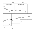
- FIG. 1 is a schematic illustration of a geographic information system including polygonal service area boundaries containing street line segments in which all street line segments are wholly contained within a respective polygon.
- the present invention will be discussed in the context of an emergency service network in the United States, commonly referred to as a 9-1-1 network.
- the teachings of the present invention are equally applicable, useful and novel in other special number calling systems, such as maintenance service networks, college campus security networks and other networks.
- the street of a civic address may be represented as a line segment with distinct address attributes and end points.
- the street line segment endpoints are each assigned a number (e.g., a house number) that determines the street address range of the street line segment.
- a house number that falls between two numbers of a street line segment may be assigned a point on the street line segment by a process of interpolating the position of the address, within the house number range along the street line segment.
- this process does not necessarily yield an accurate point on the street line segment relative to a real world position of a house address on a street.
- the appropriate service provider for a given area can be determined by using a civic address and determining which serving area the elements that represent the physical location of the civic address reside within.
- the street line segment should completely reside within one serving area polygon.
- FIG. 1 is a schematic illustration of a geographic information system including polygonal service area boundaries containing street line segments in which all street line segments are wholly contained within a respective polygon.
- a geographic area 10 represented by a geographic information system (GIS) includes polygons representing respective service areas.
- GIS geographic information system
- a polygon 12 represents a Service Area A.
- a polygon 14 represents a Service Area B.
- a polygon 16 represents a Service Area C.
- a polygon 18 represents a Service Area D.
- Main St is represented as comprising segments: Main St1 extends from an end point 22 to an end point 24 ; Main St2 extends from end point 24 to an end point 26 ; Main St3 extends from end point 26 to an end point 28 .
- Each respective Main St segment is wholly contained within a respective polygon.
- Main St1 is wholly contained within polygon 12 .
- Main St2 is also wholly contained within polygon 12 .
- Main St3 is wholly contained within polygon 14 .
- Pine St is represented as comprising segments: Pine St1 extends from an end point 32 to an end point 34 ; Pine St2 extends from end point 34 to an end point 36 . Each respective Pine St segment is wholly contained within a respective polygon. Thus, Pine St1 is wholly contained within polygon 16 . Pine St2 is also wholly contained within polygon 18 .
- Main St1 has a House Address Range 100-199
- Main St2 has a House Address Range 200-299
- Main St3 has a House Address Range 300-499
- Pine St has a House Address Range 100-599.
- Main Street 20 does not have a line segment that crosses a boundary between Service Area A and Service Area B as line segments Main St2 and Main St3 have an end point 26 at the service area boundary.
- a request for service that occurs along Main Street with a civic address within a range of interest e.g., a house number between 100-499 will fall on a street line segment that is fully contained within one and only one of Service Area A and Service Area B.
- a definitively determined service area as the proper service area for a locus of origin for a service call at a house number on Main Street between 100-499.
- a request for service that occurs on a civic address along Main Street can be well determined because every street line segment is fully contained within a service area boundary.
- FIG. 2 is a schematic illustration of a geographic information system including polygonal service area boundaries containing street line segments in which not all street line segments are wholly contained within a respective polygon.
- a geographic area 110 represented by a geographic information system (GIS) includes polygons representing respective service areas.
- GIS geographic information system
- a polygon 112 represents a Service Area E.
- a polygon 114 represents a Service Area F.
- a polygon 116 represents a Service Area G.
- a polygon 118 represents a Service Area H.
- Main St is represented as comprising, segments: Main St11 extends from an end point 122 to an end point 124 ; Main St12 extends from end point 124 to an end point 126 ; Main St13 extends from end point 126 to an end point 128 .
- Each respective Main St segment is wholly contained within a respective polygon.
- Main St11 is wholly contained within polygon 112 .
- Main St12 is also wholly contained within polygon 112 .
- Main St13 is wholly contained within polygon 114 .
- Pine St is represented as extending from an end point 132 to an end point 134 .
- Pine St spans two polygons 116 , 118 . Consequently, Pine St is not wholly contained within either polygon 116 or polygon 118 . This may be regarded as an error condition in the context of a geographic information system.
- a request for service that occurs from a civic address on Pine St cannot match a street line segment that is fully contained within one service area so that a proper service area cannot be definitely defined.
- the civic address house number must first be interpolated to a point on Pine St street line segment 130 and then the interpolated point must be found to occur in either Service Area G or Service Area H.
- the derived request for service point (i.e., the interpolated point) on Pine St approaches the point at which Pine St street line segment 130 intersects a boundary between Service Area G and Service Area H an error is more likely to occur that may result in choosing a wrong service area.
- polygon-segment error may refer to a data error either with the service area polygon or the street line segment.
- a change tracking ticket or similar recordation of the error should be created to adjust the data. It is preferable that such a recordation of error be created during the process of determining service area responsibility and changes to databases or other changes to correct the noted error be carried out later.
- One possible solution may to break Pine Street into two street line segments separated by an end point situated at the border between Service Area G and Service Area H to present Pine St1 and Pine St2 substantially as illustrated in FIG. 1 .
- an appropriate responsible service provider for a given area can be determined by using a civic address and determining within which serving area the elements that represent the physical location of the civic address reside.
- An example is 9-1-1 call processing when the calling party location information is provided in a civic address form and the call is to be delivered to a Public Safety Answering Point (PSAP) determined by geographic area polygons that overlay a street address layer.
- the street address layer may be represented by elements including street line segments with attributes of a house number range attached to endpoints that define the beginning and end of the street segment.
- the street segment must be completely contained within a PSAP serving area polygon. If the street segment is not completely contained within a PSAP serving area polygon an error can occur when determining the proper PSAP to receive the emergency call based on inaccuracy of locating the caller's house number on the geographic line segment representing the street line segment.
- Use of the present invention may result in continuous data improvement of service area boundaries represented as polygons overlaying a street address layer of street center lines with address ranges.
- determination of responsible service area given a civic address may be employed with geospatial coordinates (e.g., latitude and longitude).
- This alternate method determines a responsible service area and determines routing of a call based on a civic address by geocoding the address information and mapping the address information to the data item that defines the geographic representation of the street and address. The method ensures that the street segment is wholly contained within a jurisdictional polygon. If the street segment is not wholly contained within a jurisdictional polygon an error condition is noted and recorded in a discrepancy report that may be created to record, track, and eventually resolve noted errors. If the street line segment of interest does not fully reside within one serving area polygon the alternate method may specify that the house number be interpolated to an approximate point on the street line segment and service area determination based on the resulting geographic coordinates of the approximate point.
- This alternate method does not require geocoding to determine the serving area polygon.
- This alternate method may be employed when a street line segment does not fall completely within a serving area polygon to use a geocoding process to determine an approximate point on a particular street line segment. The approximate point may be used to determine a responsible serving area polygon and a change tracking record may be created to note the data deficiency for later correction.
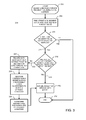
- FIG. 3 is a flow diagram illustrating the method of the present invention.
- a method 200 for treating data errors while determining serving area responsibility for a service request call begins having received the service request call, as indicated by a START locus 202 .
- the service request call includes a civic address indicating locus of origin of the service request call.
- Method 200 continues with accessing a geographic information system database relating to the civic address to find a street line segment containing the civic address, as indicated by a block 204 .
- Method 200 continues with posing a query whether a street line segment containing the civic address is contained in the geographic information system database, as indicated by a query block 206 .
- method 200 proceeds from query block 206 via a NO response line 208 to terminate as indicated by an END locus 212 .
- method 200 proceeds from query block 206 via a YES response line 214 to pose a query whether the street line segment containing the civic address is wholly contained within a serving area polygon of a polygon set relating to the serving area, as indicated by a query block 216 .
- method 200 proceeds from query block 216 via a NO response line 222 and records a data deficiency via a change tracking record for later use in correcting data, as indicated by a block 224 .
- Method 200 proceeds from block 224 to geocode the civic address to approximate geographic location of the civic address, as indicated by a block 226 .
- Method 200 proceeds from block 226 to determine an including serving area polygon containing the approximate geographic location as the serving area responsibility, as indicated by a block 228 .
- Method 200 proceeds from block 228 to return the serving area responsibility, as indicated by a block 220 .
- Method 200 thereafter proceeds from block 220 to terminate as indicated by an END locus 212 .
- method 200 proceeds from query block 216 via a YES response line 218 to return the serving area responsibility, as indicated by a block 220 .
- Method 200 thereafter proceeds from block 220 to terminate as indicated by an END locus 212 .
- FIG. 4 is a schematic diagram of the system of the present invention.
- a system 300 for treating, data errors while determining serving area responsibility for a service request call includes a service center 302 configured for receiving the service request call at a call receiving locus 304 .
- the service request call includes a civic address indicating locus of origin of the service request call (not shown in FIG. 4 ).
- a data processing apparatus 306 is coupled with service center 302 for accessing a geographic information system database 308 relating to the civic address.
- Data processing apparatus 306 is being operated so that (1) when geographic information system database 308 includes a street line segment containing the civic address (see FIGS. 1-2 ), whether the street line segment is wholly contained within a serving area polygon of a polygon set relating to the serving area is determined; (2) when the street line segment is not wholly contained within the serving area polygon, [a] a data deficiency is recorded via a change tracking record stored in a discrepancy data store 310 for later use in correcting data in the geographic information system database 308 .
- Data processing apparatus 306 is further operated to geocode the civic address to approximate geographic location of the civic address and determine an including serving area polygon containing the approximate geographic location. When data processing apparatus 306 determines that the street line segment is wholly contained within the serving area polygon, the serving area responsibility is returned, as indicated at an output locus 312 .
Abstract
Description
Claims (26)
Priority Applications (1)
| Application Number | Priority Date | Filing Date | Title |
|---|---|---|---|
| US13/473,148 US8831182B2 (en) | 2012-05-16 | 2012-05-16 | System and method for determining a responsible service area for a service request call |
Applications Claiming Priority (1)
| Application Number | Priority Date | Filing Date | Title |
|---|---|---|---|
| US13/473,148 US8831182B2 (en) | 2012-05-16 | 2012-05-16 | System and method for determining a responsible service area for a service request call |
Publications (2)
| Publication Number | Publication Date |
|---|---|
| US20130308762A1 US20130308762A1 (en) | 2013-11-21 |
| US8831182B2 true US8831182B2 (en) | 2014-09-09 |
Family
ID=49581313
Family Applications (1)
| Application Number | Title | Priority Date | Filing Date |
|---|---|---|---|
| US13/473,148 Active 2033-01-04 US8831182B2 (en) | 2012-05-16 | 2012-05-16 | System and method for determining a responsible service area for a service request call |
Country Status (1)
| Country | Link |
|---|---|
| US (1) | US8831182B2 (en) |
Cited By (1)
| Publication number | Priority date | Publication date | Assignee | Title |
|---|---|---|---|---|
| US10394857B2 (en) | 2016-01-29 | 2019-08-27 | Dmti Spatial, Inc. | Method and apparatus for identifying one or more territories |
Families Citing this family (3)
| Publication number | Priority date | Publication date | Assignee | Title |
|---|---|---|---|---|
| US9641679B1 (en) * | 2014-09-29 | 2017-05-02 | 911 Datamaster, Inc. | Geographic policy routing function |
| US10284998B2 (en) | 2016-02-08 | 2019-05-07 | K/S Himpp | Hearing augmentation systems and methods |
| US10845207B2 (en) * | 2018-01-18 | 2020-11-24 | Verizon Patent And Licensing Inc. | Navigation based on regional navigation restrictions |
Citations (13)
| Publication number | Priority date | Publication date | Assignee | Title |
|---|---|---|---|---|
| US20050190892A1 (en) * | 2004-02-27 | 2005-09-01 | Dawson Martin C. | Determining the geographical location from which an emergency call originates in a packet-based communications network |
| US20070238448A1 (en) * | 2002-10-18 | 2007-10-11 | Gallagher Michael D | Method and system of providing landline equivalent location information over an integrated communication system |
| US20090275350A1 (en) * | 2008-05-05 | 2009-11-05 | Todd Poremba | Ingress/Egress call module |
| US20100128935A1 (en) * | 2003-09-17 | 2010-05-27 | Navteq North America, Llc | Location-referenced Photograph Repository |
| US20100131196A1 (en) * | 2006-12-12 | 2010-05-27 | Pitney Bowes Inc. | Reverse geocoding system using combined street segment and point datasets |
| US20100185556A1 (en) * | 1998-12-08 | 2010-07-22 | Srihari Kumar | Portfolio Synchronizing Between Different Interfaces |
| US20100281020A1 (en) * | 2008-01-11 | 2010-11-04 | Drubner Jeffrey M | Method and system for uniquely identifying a person to the exclusion of all others |
| US8014341B1 (en) * | 2006-05-08 | 2011-09-06 | Embarq Holdings Company, Llc | Method and intermediary device for reporting a civic address during an emergency call |
| US8060389B2 (en) * | 2000-06-07 | 2011-11-15 | Apple Inc. | System and method for anonymous location based services |
| US20120051603A1 (en) * | 2006-11-17 | 2012-03-01 | Corelogic, Inc. | Updating a database with determined change identifiers |
| US20120239670A1 (en) * | 2011-03-17 | 2012-09-20 | Gary Randall Horn | Systems and methods for creating standardized street addresses from raw address data |
| US20130090086A1 (en) * | 2010-06-25 | 2013-04-11 | Telefonica, S.A. | System and method for validating a user equipment location in a telecommunication network |
| US20130275863A1 (en) * | 2009-11-13 | 2013-10-17 | Hartford Fire Insurance Company | System and method for translating insurance-related data |
-
2012
- 2012-05-16 US US13/473,148 patent/US8831182B2/en active Active
Patent Citations (13)
| Publication number | Priority date | Publication date | Assignee | Title |
|---|---|---|---|---|
| US20100185556A1 (en) * | 1998-12-08 | 2010-07-22 | Srihari Kumar | Portfolio Synchronizing Between Different Interfaces |
| US8060389B2 (en) * | 2000-06-07 | 2011-11-15 | Apple Inc. | System and method for anonymous location based services |
| US20070238448A1 (en) * | 2002-10-18 | 2007-10-11 | Gallagher Michael D | Method and system of providing landline equivalent location information over an integrated communication system |
| US20100128935A1 (en) * | 2003-09-17 | 2010-05-27 | Navteq North America, Llc | Location-referenced Photograph Repository |
| US20050190892A1 (en) * | 2004-02-27 | 2005-09-01 | Dawson Martin C. | Determining the geographical location from which an emergency call originates in a packet-based communications network |
| US8014341B1 (en) * | 2006-05-08 | 2011-09-06 | Embarq Holdings Company, Llc | Method and intermediary device for reporting a civic address during an emergency call |
| US20120051603A1 (en) * | 2006-11-17 | 2012-03-01 | Corelogic, Inc. | Updating a database with determined change identifiers |
| US20100131196A1 (en) * | 2006-12-12 | 2010-05-27 | Pitney Bowes Inc. | Reverse geocoding system using combined street segment and point datasets |
| US20100281020A1 (en) * | 2008-01-11 | 2010-11-04 | Drubner Jeffrey M | Method and system for uniquely identifying a person to the exclusion of all others |
| US20090275350A1 (en) * | 2008-05-05 | 2009-11-05 | Todd Poremba | Ingress/Egress call module |
| US20130275863A1 (en) * | 2009-11-13 | 2013-10-17 | Hartford Fire Insurance Company | System and method for translating insurance-related data |
| US20130090086A1 (en) * | 2010-06-25 | 2013-04-11 | Telefonica, S.A. | System and method for validating a user equipment location in a telecommunication network |
| US20120239670A1 (en) * | 2011-03-17 | 2012-09-20 | Gary Randall Horn | Systems and methods for creating standardized street addresses from raw address data |
Cited By (1)
| Publication number | Priority date | Publication date | Assignee | Title |
|---|---|---|---|---|
| US10394857B2 (en) | 2016-01-29 | 2019-08-27 | Dmti Spatial, Inc. | Method and apparatus for identifying one or more territories |
Also Published As
| Publication number | Publication date |
|---|---|
| US20130308762A1 (en) | 2013-11-21 |
Similar Documents
| Publication | Publication Date | Title |
|---|---|---|
| US8358645B2 (en) | Determining a physical location of a VoIP endpoint device utilized to originate an emergency call | |
| US6529722B1 (en) | System and method for enhanced 9-1-1 address development, maintenance and call routing using road access zones | |
| US9275073B2 (en) | Associating metro street address guide (MSAG) validated addresses with geographic map data | |
| EP2553990B1 (en) | Method and apparatus for use of performance history data in positioning method selection | |
| US8160614B2 (en) | Automated concierge system and method | |
| US8830987B2 (en) | IP-based call answering point selection and routing | |
| US8831182B2 (en) | System and method for determining a responsible service area for a service request call | |
| US7640027B2 (en) | Mobile communication terminal capable of determining position and method of determining position in the mobile communication terminal | |
| WO2008013554A1 (en) | Providing an indication of network capabilities to a user for special number calls | |
| US20110206036A1 (en) | System and method for method for providing an indication of certainty of location of origin of an internet protocol emergency call | |
| US20150341769A1 (en) | Voice Over Internet Protocol (VOIP) E911 Metro Street Address Guide (MSAG) Validation | |
| US20170013435A1 (en) | Automated proximate location association mechanism for wireless emergency services | |
| US20040111312A1 (en) | Validating turfs for work orders | |
| US8538679B1 (en) | Enhanced geocoding | |
| CN106991185A (en) | The hotel's latitude and longitude information maintaining method and system of OTA websites | |
| CA3053971C (en) | Road determination method and device | |
| US20160330321A1 (en) | House number normalization for master street address guide (msag) address matching | |
| US10212281B2 (en) | System and method for handling repetitive calls at call center | |
| CN103021261A (en) | Automatic digital map correction method and device | |
| CN113473398A (en) | Mobile phone signaling data stop point identification method, device and storage medium | |
| US7932857B2 (en) | GPS for communications facility records | |
| CN106228160B (en) | Headend equipment localization method and device | |
| US9491292B2 (en) | Methods and systems for storage and retrieval of originating caller location information in an emergency services system | |
| US20110092182A1 (en) | Method and system for maintaining response center information | |
| US20140045523A1 (en) | Methods and apparatus for tracking location of portable electronic device |
Legal Events
| Date | Code | Title | Description |
|---|---|---|---|
| AS | Assignment |
Owner name: WEST CORPORATION, NEBRASKA Free format text: ASSIGNMENT OF ASSIGNORS INTEREST;ASSIGNOR:NELSON, MICHAEL J.;REEL/FRAME:028290/0530 Effective date: 20120522 |
|
| STCF | Information on status: patent grant |
Free format text: PATENTED CASE |
|
| AS | Assignment |
Owner name: WELLS FARGO BANK, NATIONAL ASSOCIATION, NORTH CARO Free format text: SECURITY INTEREST;ASSIGNOR:WEST CORPORATION;REEL/FRAME:034694/0684 Effective date: 20141223 |
|
| AS | Assignment |
Owner name: U.S. BANK NATIONAL ASSOCIATION, MINNESOTA Free format text: SECURITY INTEREST;ASSIGNORS:WEST CORPORATION;WEST INTERACTIVE SERVICES CORPORATION;WEST SAFETY SERVICES, INC.;AND OTHERS;REEL/FRAME:039093/0944 Effective date: 20160617 |
|
| AS | Assignment |
Owner name: CREDIT SUISSE AG, CAYMAN ISLANDS BRANCH, AS COLLATERAL AGENT, NEW YORK Free format text: NOTICE OF GRANT OF SECURITY INTEREST IN PATENTS (FIRST LIEN);ASSIGNOR:WEST CORPORATION;REEL/FRAME:044166/0901 Effective date: 20171010 Owner name: CREDIT SUISSE AG, CAYMAN ISLANDS BRANCH, AS COLLAT Free format text: NOTICE OF GRANT OF SECURITY INTEREST IN PATENTS (FIRST LIEN);ASSIGNOR:WEST CORPORATION;REEL/FRAME:044166/0901 Effective date: 20171010 Owner name: WEST CORPORATION, NEBRASKA Free format text: TERMINATION AND RELEASE OF SECURITY INTEREST IN PATENTS RECORDED AT REEL 034694, FRAME 0684;ASSIGNOR:WELLS FARGO BANK, NATIONAL ASSOCIATION;REEL/FRAME:044168/0967 Effective date: 20171010 |
|
| MAFP | Maintenance fee payment |
Free format text: PAYMENT OF MAINTENANCE FEE, 4TH YEAR, LARGE ENTITY (ORIGINAL EVENT CODE: M1551) Year of fee payment: 4 |
|
| AS | Assignment |
Owner name: WEST INTERACTIVE SERVICES CORPORATION, NEBRASKA Free format text: RELEASE BY SECURED PARTY;ASSIGNOR:U.S. BANK NATIONAL ASSOCIATION;REEL/FRAME:046046/0547 Effective date: 20180430 Owner name: WEST SAFETY SERVICES, INC., NEBRASKA Free format text: RELEASE BY SECURED PARTY;ASSIGNOR:U.S. BANK NATIONAL ASSOCIATION;REEL/FRAME:046046/0547 Effective date: 20180430 Owner name: WEST UNIFIED COMMUNICATIONS SERVICES, INC., NEBRAS Free format text: RELEASE BY SECURED PARTY;ASSIGNOR:U.S. BANK NATIONAL ASSOCIATION;REEL/FRAME:046046/0547 Effective date: 20180430 Owner name: WEST CORPORATION, NEBRASKA Free format text: RELEASE BY SECURED PARTY;ASSIGNOR:U.S. BANK NATIONAL ASSOCIATION;REEL/FRAME:046046/0547 Effective date: 20180430 Owner name: RELIANCE COMMUNICATIONS, LLC, NEBRASKA Free format text: RELEASE BY SECURED PARTY;ASSIGNOR:U.S. BANK NATIONAL ASSOCIATION;REEL/FRAME:046046/0547 Effective date: 20180430 |
|
| MAFP | Maintenance fee payment |
Free format text: PAYMENT OF MAINTENANCE FEE, 8TH YEAR, LARGE ENTITY (ORIGINAL EVENT CODE: M1552); ENTITY STATUS OF PATENT OWNER: LARGE ENTITY Year of fee payment: 8 |
|
| AS | Assignment |
Owner name: U.S. BANK TRUST COMPANY, NATIONAL ASSOCIATION, AS COLLATERAL AGENT, NEW YORK Free format text: NOTICE OF GRANT OF SECURITY INTEREST (SECOND LIEN) IN PATENTS;ASSIGNORS:CX360, INC.;WEST TECHNOLOGY GROUP, LLC (FKA INTRADO CORPORATION, FKA WEST CORPORATION);INTRADO INTERACTIVE SERVICES CORPORATION (FKA WEST INTERACTIVE SERVICES CORPORATION, FKA COBALT ACQUISITION COMPANY);REEL/FRAME:062571/0018 Effective date: 20230131 |
|
| AS | Assignment |
Owner name: INTRADO CORPORATION, NEBRASKA Free format text: CHANGE OF NAME;ASSIGNOR:WEST CORPORATION;REEL/FRAME:063239/0900 Effective date: 20190920 Owner name: WEST TECHNOLOGY GROUP, LLC, NEW YORK Free format text: CHANGE OF NAME;ASSIGNOR:INTRADO CORPORATION;REEL/FRAME:063239/0876 Effective date: 20221222 |