Hubbardston, Massachusetts
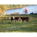
Hubbardston: Having fun! a look from Old Princeton Road 2006
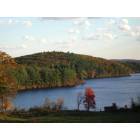
Hubbardston: Comet Pond a view from Old Princeton Road 2006
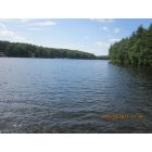
Hubbardston: Comet Pond
- add
your
Submit your own pictures of this town and show them to the world
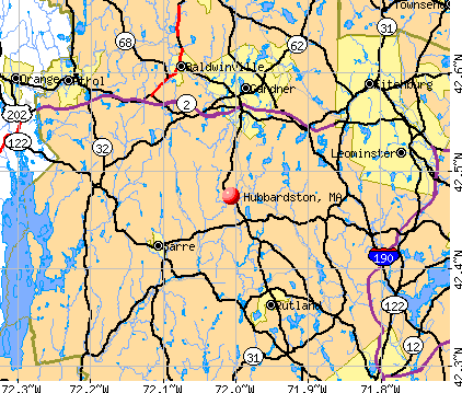
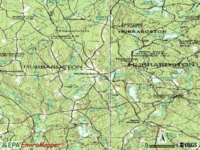
- OSM Map
- General Map
- Google Map
- MSN Map
Population change since 2000: +12.1%
 |
| Males: 2,189 | |
| Females: 2,193 |
| Median resident age: | 41.6 years |
| Massachusetts median age: | 39.2 years |
Zip codes: 01452.
| Hubbardston: | $110,740 |
| MA: | $94,488 |
Estimated per capita income in 2022: $44,986 (it was $23,072 in 2000)
Hubbardston town income, earnings, and wages data
Estimated median house or condo value in 2022: $400,980 (it was $145,200 in 2000)
| Hubbardston: | $400,980 |
| MA: | $534,700 |
Mean prices in 2022: all housing units: $419,164; detached houses: $447,621; townhouses or other attached units: $343,592; in 2-unit structures: $323,295; in 3-to-4-unit structures: $332,295; in 5-or-more-unit structures: $232,758; mobile homes: $113,885
Detailed information about poverty and poor residents in Hubbardston, MA


- 4,22596.4%White alone
- 631.4%Hispanic
- 441.0%Two or more races
- 210.5%Black alone
- 210.5%Asian alone
- 70.2%Other race alone
- 10.02%American Indian alone

Races in Hubbardston detailed stats: ancestries, foreign born residents, place of birth
According to our research of Massachusetts and other state lists, there was 1 registered sex offender living in Hubbardston, Massachusetts as of May 16, 2024.
The ratio of all residents to sex offenders in Hubbardston is 4,382 to 1.
The ratio of registered sex offenders to all residents in this city is much lower than the state average.
Type |
2009 |
2010 |
2011 |
2012 |
2013 |
2014 |
|---|---|---|---|---|---|---|
| Murders (per 100,000) | 0 (0.0) | 0 (0.0) | 0 (0.0) | 0 (0.0) | 0 (0.0) | 0 (0.0) |
| Rapes (per 100,000) | 0 (0.0) | 1 (22.8) | 1 (22.7) | 3 (67.6) | 0 (0.0) | 0 (0.0) |
| Robberies (per 100,000) | 0 (0.0) | 1 (22.8) | 0 (0.0) | 0 (0.0) | 0 (0.0) | 0 (0.0) |
| Assaults (per 100,000) | 12 (262.9) | 20 (456.4) | 15 (340.2) | 8 (180.3) | 6 (134.9) | 4 (89.0) |
| Burglaries (per 100,000) | 10 (219.1) | 17 (388.0) | 22 (499.0) | 20 (450.9) | 20 (449.6) | 1 (22.3) |
| Thefts (per 100,000) | 19 (416.2) | 22 (502.1) | 21 (476.3) | 31 (698.8) | 21 (472.1) | 9 (200.3) |
| Auto thefts (per 100,000) | 2 (43.8) | 4 (91.3) | 1 (22.7) | 2 (45.1) | 3 (67.4) | 2 (44.5) |
| Arson (per 100,000) | 1 (21.9) | 0 (0.0) | 0 (0.0) | 0 (0.0) | 0 (0.0) | 1 (22.3) |
| City-Data.com crime index | 88.1 | 170.9 | 142.0 | 153.3 | 82.7 | 30.9 |
The City-Data.com crime index weighs serious crimes and violent crimes more heavily. Higher means more crime, U.S. average is 246.1. It adjusts for the number of visitors and daily workers commuting into cities.
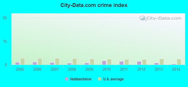
Crime rate in Hubbardston detailed stats: murders, rapes, robberies, assaults, burglaries, thefts, arson
Full-time law enforcement employees in 2015, including police officers: 6 (6 officers - 6 male; 0 female).
| Officers per 1,000 residents here: | 1.32 |
| Massachusetts average: | 2.54 |
 Recent articles from our blog. Our writers, many of them Ph.D. graduates or candidates, create easy-to-read articles on a wide variety of topics.

 | Post homes in MA that people like (55 replies) |
| Affordable places to live for a boring hermit? (88 replies) |
| Big MA Ancestry Data Thread by Town (31 replies) |
| Central or Western MA towns for Seniors (16 replies) |
| Republicanism in MA (49 replies) |
| Dream Boston home, where would you live? (51 replies) |
Latest news from Hubbardston, MA collected exclusively by city-data.com from local newspapers, TV, and radio stations
Ancestries: Irish (19.8%), French (19.2%), English (17.0%), French Canadian (11.0%), Italian (10.3%), Polish (7.2%).
Current Local Time: EST time zone
Incorporated in 1775
Elevation: 993 feet
Land area: 41.0 square miles.
Population density: 107 people per square mile (very low).
85 residents are foreign born (0.9% North America, 0.7% Europe, 0.3% Oceania).
| This town: | 2.2% |
| Massachusetts: | 12.2% |
| Hubbardston town: | 1.2% ($1,714) |
| Massachusetts: | 1.3% ($2,336) |
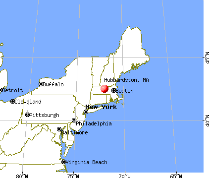
Nearest city with pop. 50,000+: Worcester, MA  (17.5 miles , pop. 172,648).
Nearest city with pop. 200,000+: Boston, MA (47.6 miles , pop. 589,141).
Nearest city with pop. 1,000,000+: Bronx, NY (148.7 miles , pop. 1,332,650).
Nearest cities:
Latitude: 42.48 N, Longitude: 72.00 W
Area code: 978

Single-family new house construction building permits:
- 2022: 11 buildings, average cost: $221,600
- 2021: 15 buildings, average cost: $213,100
- 2020: 6 buildings, average cost: $132,800
- 2019: 6 buildings, average cost: $132,800
- 2018: 26 buildings, average cost: $145,100
- 2017: 25 buildings, average cost: $145,100
- 2016: 26 buildings, average cost: $145,100
- 2015: 24 buildings, average cost: $145,100
- 2014: 29 buildings, average cost: $145,100
- 2013: 21 buildings, average cost: $145,100
- 2012: 9 buildings, average cost: $207,200
- 2011: 6 buildings, average cost: $309,900
- 2010: 3 buildings, average cost: $171,000
- 2009: 20 buildings, average cost: $159,600
- 2008: 13 buildings, average cost: $159,600
- 2007: 18 buildings, average cost: $159,600
- 2006: 34 buildings, average cost: $151,200
- 2005: 38 buildings, average cost: $151,200
- 2004: 38 buildings, average cost: $151,200
- 2003: 28 buildings, average cost: $144,200
- 2002: 29 buildings, average cost: $139,500
- 2001: 26 buildings, average cost: $131,800
- 2000: 38 buildings, average cost: $132,200
- 1999: 53 buildings, average cost: $123,600
- 1998: 51 buildings, average cost: $101,900
- 1997: 36 buildings, average cost: $99,000


| Here: | 3.0% |
| Massachusetts: | 3.5% |


- Health care (9.6%)
- Construction (8.7%)
- Educational services (7.3%)
- Public administration (7.2%)
- Computer & electronic products (6.7%)
- Professional, scientific, technical services (6.2%)
- Accommodation & food services (5.3%)

- Construction (14.4%)
- Computer & electronic products (9.2%)
- Public administration (7.5%)
- Professional, scientific, technical services (5.4%)
- Accommodation & food services (4.9%)
- Metal & metal products (3.8%)
- Finance & insurance (3.5%)

- Health care (17.1%)
- Educational services (12.3%)
- Professional, scientific, technical services (7.3%)
- Public administration (6.9%)
- Accommodation & food services (5.7%)
- Finance & insurance (4.8%)
- Computer & electronic products (3.8%)

- Other management occupations, except farmers and farm managers (6.7%)
- Other sales and related occupations, including supervisors (4.3%)
- Other office and administrative support workers, including supervisors (4.2%)
- Electrical equipment mechanics and other installation, maintenance, and repair workers, including supervisors (3.7%)
- Other production occupations, including supervisors (3.5%)
- Driver/sales workers and truck drivers (3.5%)
- Preschool, kindergarten, elementary, and middle school teachers (2.9%)

- Other management occupations, except farmers and farm managers (6.7%)
- Driver/sales workers and truck drivers (6.4%)
- Electrical equipment mechanics and other installation, maintenance, and repair workers, including supervisors (6.1%)
- Other production occupations, including supervisors (6.1%)
- Engineers (4.8%)
- Law enforcement workers, including supervisors (4.6%)
- Metal workers and plastic workers (4.0%)

- Other office and administrative support workers, including supervisors (7.2%)
- Other management occupations, except farmers and farm managers (6.7%)
- Other sales and related occupations, including supervisors (5.4%)
- Registered nurses (5.2%)
- Preschool, kindergarten, elementary, and middle school teachers (5.1%)
- Secretaries and administrative assistants (4.8%)
- Nursing, psychiatric, and home health aides (3.0%)
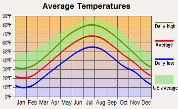
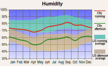
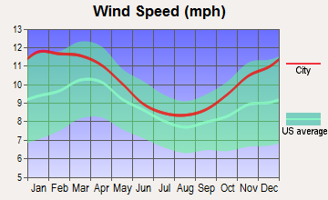
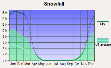
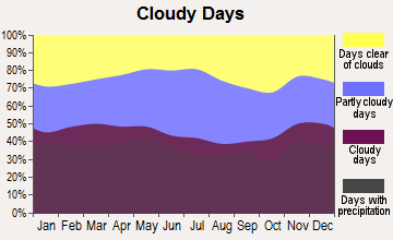
Average climate in Hubbardston, Massachusetts
Based on data reported by over 4,000 weather stations

(lower is better)

Air Quality Index (AQI) level in 2022 was 65.7. This is about average.
| City: | 65.7 |
| U.S.: | 72.6 |

Carbon Monoxide (CO) [ppm] level in 2022 was 0.259. This is about average. Closest monitor was 17.7 miles away from the city center.
| City: | 0.259 |
| U.S.: | 0.251 |

Nitrogen Dioxide (NO2) [ppb] level in 2022 was 10.1. This is significantly worse than average. Closest monitor was 12.3 miles away from the city center.
| City: | 10.1 |
| U.S.: | 5.1 |

Sulfur Dioxide (SO2) [ppb] level in 2022 was 0.306. This is significantly better than average. Closest monitor was 6.8 miles away from the city center.
| City: | 0.306 |
| U.S.: | 1.515 |

Ozone [ppb] level in 2022 was 32.7. This is about average. Closest monitor was 10.5 miles away from the city center.
| City: | 32.7 |
| U.S.: | 33.3 |


Particulate Matter (PM2.5) [µg/m3] level in 2022 was 7.81. This is about average. Closest monitor was 13.4 miles away from the city center.
| City: | 7.81 |
| U.S.: | 8.11 |
Tornado activity:
Hubbardston-area historical tornado activity is above Massachusetts state average. It is 14% smaller than the overall U.S. average.
On 6/9/1953, a category F4 (max. wind speeds 207-260 mph) tornado 8.9 miles away from the Hubbardston town center killed 90 people and injured 1228 people and caused between $50,000,000 and $500,000,000 in damages.
On 6/22/1981, a category F3 (max. wind speeds 158-206 mph) tornado 2.3 miles away from the town center injured 3 people and caused between $5000 and $50,000 in damages.
Earthquake activity:
Hubbardston-area historical earthquake activity is significantly above Massachusetts state average. It is 71% smaller than the overall U.S. average.On 10/7/1983 at 10:18:46, a magnitude 5.3 (5.1 MB, 5.3 LG, 5.1 ML, Class: Moderate, Intensity: VI - VII) earthquake occurred 156.2 miles away from the city center
On 4/20/2002 at 10:50:47, a magnitude 5.3 (5.3 ML, Depth: 3.0 mi) earthquake occurred 164.6 miles away from Hubbardston center
On 4/20/2002 at 10:50:47, a magnitude 5.2 (5.2 MB, 4.2 MS, 5.2 MW, 5.0 MW) earthquake occurred 163.6 miles away from Hubbardston center
On 1/19/1982 at 00:14:42, a magnitude 4.7 (4.5 MB, 4.7 MD, 4.5 LG, Class: Light, Intensity: IV - V) earthquake occurred 73.5 miles away from the city center
On 10/16/2012 at 23:12:25, a magnitude 4.7 (4.7 ML, Depth: 10.0 mi) earthquake occurred 102.9 miles away from the city center
On 10/2/1994 at 11:27:22, a magnitude 3.7 (3.5 LG, 3.7 LG, Depth: 6.2 mi, Class: Light, Intensity: II - III) earthquake occurred 16.9 miles away from the city center
Magnitude types: regional Lg-wave magnitude (LG), body-wave magnitude (MB), duration magnitude (MD), local magnitude (ML), surface-wave magnitude (MS), moment magnitude (MW)
Natural disasters:
The number of natural disasters in Worcester County (27) is a lot greater than the US average (15).Major Disasters (Presidential) Declared: 15
Emergencies Declared: 12
Causes of natural disasters: Floods: 9, Storms: 8, Hurricanes: 6, Snowstorms: 5, Winter Storms: 4, Blizzards: 2, Snows: 2, Fire: 1, Heavy Rain: 1, Snowfall: 1, Tornado: 1, Wind: 1 (Note: some incidents may be assigned to more than one category).
Hospitals and medical centers near Hubbardston:
- LEGEND REHABILITATION AND NURSING CENTER (Nursing Home, about 7 miles away; GARDNER, MA)
- WACHUSETT MANOR (Nursing Home, about 7 miles away; GARDNER, MA)
- GARDNER MANOR (Nursing Home, about 8 miles away; GARDNER, MA)
- GARDNER SKILLED NURSING CENTER (Nursing Home, about 8 miles away; GARDNER, MA)
- HEYWOOD HOSPITAL Acute Care Hospitals (about 8 miles away; GARDNER, MA)
- RUTLAND HEIGHTS HOSP- SNF (Nursing Home, about 8 miles away; RUTLAND, MA)
- GARDNER VNA (Home Health Center, about 9 miles away; GARDNER, MA)
Amtrak station near Hubbardston:
Colleges/universities with over 2000 students nearest to Hubbardston:
- Mount Wachusett Community College (about 9 miles; Gardner, MA; Full-time enrollment: 3,143)
- Fitchburg State University (about 14 miles; Fitchburg, MA; FT enrollment: 5,010)
- Assumption College (about 16 miles; Worcester, MA; FT enrollment: 2,580)
- Quinsigamond Community College (about 16 miles; Worcester, MA; FT enrollment: 5,877)
- Worcester State University (about 17 miles; Worcester, MA; FT enrollment: 5,426)
- Worcester Polytechnic Institute (about 17 miles; Worcester, MA; FT enrollment: 3,930)
- Clark University (about 18 miles; Worcester, MA; FT enrollment: 3,687)
Public elementary/middle school in Hubbardston:
- HUBBARDSTON CENTER (Students: 467, Location: 8 ELM STREET, Grades: KG-6)
Points of interest:
Notable locations in Hubbardston: Hubbardston Fire Department Station 2 Headquarters (A), Hubbardston Fire Department Station 1 (B), Hubbardston Town Hall (C). Display/hide their locations on the map
Churches in Hubbardston include: Hubbardston Federated Church (A), Evangelical Congregational Church (B). Display/hide their locations on the map
Cemeteries: Nightingale Cemetery (1), Pine Grove Cemetery (2), Forest Hill Cemetery (3), Rural Glen Cemetery (4), Tooker Cemetery (5). Display/hide their locations on the map
Lakes and reservoirs: Moosehorn Pond (A), Marcan Pond (B), Cunningham Pond (C), Bennett Pond (D), Natty Pond (E), Waite Pond (F), Lovewell Pond (G), Brigham Pond (H). Display/hide their locations on the map
Streams, rivers, and creeks: Natty Pond Brook (A), Joslin Brook (B), Mason Brook (C). Display/hide their locations on the map
Park in Hubbardston: Hubbardston Wildlife Management Area (1). Display/hide its location on the map
Birthplace of: Jonas Gilman Clark - Manufacturing businesspeople.
Drinking water stations with addresses in Hubbardston and their reported violations in the past:
SILVERLEAF HOLLOW CONDOMINIUMS (Population served: 40, Groundwater):Past monitoring violations:
- Monitoring, Repeat Major (TCR) - In AUG-2013, Contaminant: Coliform (TCR). Follow-up actions: St AO (w/o penalty) issued (SEP-06-2013)
- One routine major monitoring violation
- 2 minor monitoring violations
- 26 regular monitoring violations
| This town: | 2.8 people |
| Massachusetts: | 2.5 people |
| This town: | 78.5% |
| Whole state: | 63.0% |
| This town: | 6.4% |
| Whole state: | 7.0% |
Likely homosexual households (counted as self-reported same-sex unmarried-partner households)
- Lesbian couples: 0.4% of all households
- Gay men: 0.3% of all households
| This town: | 3.7% |
| Whole state: | 9.3% |
| This town: | 2.3% |
| Whole state: | 4.4% |
12 people in homes for the mentally retarded in 2000
10 people in orthopedic wards and institutions for the physically handicapped in 2000
For population 15 years and over in Hubbardston:

- Never married: 17.7%
- Now married: 71.2%
- Separated: 0.8%
- Widowed: 2.9%
- Divorced: 7.4%
For population 25 years and over in Hubbardston:
- High school or higher: 92.6%
- Bachelor's degree or higher: 33.8%
- Graduate or professional degree: 7.1%
- Unemployed: 2.7%
- Mean travel time to work (commute): 35.5 minutes


| Here: | 9.1 |
| Massachusetts average: | 13.1 |


Graphs represent county-level data. Detailed 2008 Election Results
Religion statistics for Hubbardston, MA (based on Worcester County data)


| Religion | Adherents | Congregations |
|---|---|---|
| Catholic | 306,925 | 118 |
| Mainline Protestant | 43,326 | 171 |
| Evangelical Protestant | 37,511 | 203 |
| Other | 18,931 | 69 |
| Orthodox | 7,935 | 15 |
| Black Protestant | 497 | 6 |
| None | 383,427 | - |
Food Environment Statistics:
| This county: | 1.73 / 10,000 pop. |
| Massachusetts: | 1.98 / 10,000 pop. |
| Worcester County: | 0.05 / 10,000 pop. |
| Massachusetts: | 0.05 / 10,000 pop. |
| This county: | 1.79 / 10,000 pop. |
| Massachusetts: | 2.22 / 10,000 pop. |
| This county: | 2.22 / 10,000 pop. |
| State: | 1.77 / 10,000 pop. |
| This county: | 7.27 / 10,000 pop. |
| Massachusetts: | 8.76 / 10,000 pop. |
| Worcester County: | 8.0% |
| Massachusetts: | 8.1% |
| Worcester County: | 24.0% |
| Massachusetts: | 22.5% |
| Worcester County: | 16.6% |
| Massachusetts: | 16.5% |
4.71% of this county's 2021 resident taxpayers lived in other counties in 2020 ($76,229 average adjusted gross income)
| Here: | 4.71% |
| Massachusetts average: | 6.35% |
0.02% of residents moved from foreign countries ($100 average AGI)
Worcester County: 0.02% Massachusetts average: 0.01%
Top counties from which taxpayers relocated into this county between 2020 and 2021:
| from Middlesex County, MA | |
| from Norfolk County, MA | |
| from Suffolk County, MA |
4.84% of this county's 2020 resident taxpayers moved to other counties in 2021 ($87,252 average adjusted gross income)
| Here: | 4.84% |
| Massachusetts average: | 7.18% |
0.03% of residents moved to foreign countries ($199 average AGI)
Worcester County: 0.03% Massachusetts average: 0.02%
Top counties to which taxpayers relocated from this county between 2020 and 2021:
| to Middlesex County, MA | |
| to Norfolk County, MA | |
| to Suffolk County, MA |
Strongest AM radio stations in Hubbardston:
- WCRN (830 AM; 50 kW; WORCESTER, MA; Owner: CARTER BROADCASTING CORPORATION)
- WVNE (760 AM; daytime; 25 kW; LEICESTER, MA; Owner: BLOUNT MASSCOM, INC.)
- WTAG (580 AM; 5 kW; WORCESTER, MA; Owner: CAPSTAR TX LIMITED PARTNERSHIP)
- WRKO (680 AM; 50 kW; BOSTON, MA; Owner: ENTERCOM BOSTON LICENSE, LLC)
- WKOX (1200 AM; 50 kW; FRAMINGHAM, MA; Owner: CAPSTAR TX LIMITED PARTNERSHIP)
- WNNZ (640 AM; 50 kW; WESTFIELD, MA; Owner: CLEAR CHANNEL BROADCASTING LICENSES, INC.)
- WBIX (1060 AM; 40 kW; NATICK, MA; Owner: LANGER BROADCASTING CORPORATION)
- WEEI (850 AM; 50 kW; BOSTON, MA; Owner: ENTERCOM BOSTON LICENSE, LLC)
- WEIM (1280 AM; 5 kW; FITCHBURG, MA; Owner: LIVEAIR COMMUNICATIONS, INC.)
- WALE (990 AM; 50 kW; GREENVILLE, RI; Owner: NORTH AMERICAN BROADCASTING CO., INC.)
- WAMG (890 AM; 25 kW; DEDHAM, MA; Owner: MEGA COMMUNICATIONS OF DEDHAM LICENSEE, LLC)
- WWZN (1510 AM; 50 kW; BOSTON, MA; Owner: ROSE CITY RADIO CORPORATION)
- WFGL (960 AM; 2 kW; FITCHBURG, MA; Owner: CSN INTERNATIONAL)
Strongest FM radio stations in Hubbardston:
- WXLO (104.5 FM; FITCHBURG, MA; Owner: CITADEL BROADCASTING COMPANY)
- WAAF (107.3 FM; WORCESTER, MA; Owner: ENTERCOM BOSTON LICENSE, LLC)
- WSRS (96.1 FM; WORCESTER, MA; Owner: CAPSTAR TX LIMITED PARTNERSHIP)
- WAHL (99.9 FM; ATHOL, MA; Owner: CITADEL BROADCASTING COMPANY)
- WFEX (92.1 FM; PETERBOROUGH, NH; Owner: FNX BROADCASTING OF NEW HAMPSHIRE LLC)
- WFCR (88.5 FM; AMHERST, MA; Owner: UNIVERSITY OF MASSACHUSETTS)
- WINQ (97.7 FM; WINCHENDON, MA; Owner: SAGA COMMUNICATIONS OF NEW ENGLAND, LLC)
- WAMH (89.3 FM; AMHERST, MA; Owner: TRUSTEES OF AMHERST COLLEGE)
- WHDQ (106.1 FM; CLAREMONT, NH; Owner: GREAT NORTHERN RADIO, L.L.C.)
- WBMX (98.5 FM; BOSTON, MA; Owner: INFINITY RADIO OPERATIONS INC.)
- WAMC-FM (90.3 FM; ALBANY, NY; Owner: WAMC)
- WJMN (94.5 FM; BOSTON, MA; Owner: AMFM RADIO LICENSES, L.L.C.)
- WCRB (102.5 FM; WALTHAM, MA; Owner: CHARLES RIVER BROADCASTING WCRB LICE)
- WTKK (96.9 FM; BOSTON, MA; Owner: GREATER BOSTON RADIO, INC.)
- WHYN-FM (93.1 FM; SPRINGFIELD, MA; Owner: CLEAR CHANNEL BROADCASTING LICENSES, INC.)
- WROR-FM (105.7 FM; FRAMINGHAM, MA; Owner: GREATER BOSTON RADIO, INC.)
- WBOS (92.9 FM; BROOKLINE, MA; Owner: GREATER BOSTON RADIO, INC.)
- WBPR (91.9 FM; WORCESTER, MA; Owner: UNIVERSITY OF MASSACHUSETTS)
- WGBH (89.7 FM; BOSTON, MA; Owner: WGBH EDUCATIONAL FOUNDATION)
- W246AM (97.1 FM; AMHERST, MA; Owner: GREAT NORTHERN RADIO, LLC)
TV broadcast stations around Hubbardston:
- WUNI (Channel 27; WORCESTER, MA; Owner: ENTRAVISION HOLDINGS, LLC)
- WYDN (Channel 48; WORCESTER, MA; Owner: EDUCATIONAL PUBLIC TV CORPORATION)
- WUTF (Channel 66; MARLBOROUGH, MA; Owner: TELEFUTURA BOSTON LLC)
- WCVB-TV (Channel 5; BOSTON, MA; Owner: WCVB HEARST-ARGYLE TV, INC.)
- WGBH-TV (Channel 2; BOSTON, MA; Owner: WGBH EDUCATIONAL FOUNDATION)
- WHDH-TV (Channel 7; BOSTON, MA; Owner: WHDH-TV)
- WMFP (Channel 62; LAWRENCE, MA; Owner: WSAH LICENSE, INC.)
- WBZ-TV (Channel 4; BOSTON, MA; Owner: VIACOM INC.)
- WGBX-TV (Channel 44; BOSTON, MA; Owner: WGBH EDUCATIONAL FOUNDATION)
- WSBK-TV (Channel 38; BOSTON, MA; Owner: VIACOM INC.)
- WLVI-TV (Channel 56; CAMBRIDGE, MA; Owner: WLVI, INC.)
- WFXT (Channel 25; BOSTON, MA; Owner: FOX TELEVISION STATIONS INC.)
- WCRN-LP (Channel 34; LEICESTER, MA; Owner: CARTER BROADCASTING CORPORATION)
- W40BO (Channel 40; BOSTON, MA; Owner: PAXSON COMMUNICATIONS LPTV, INC.)

- National Bridge Inventory (NBI) Statistics
- 9Number of bridges
- 39ft / 12.4mTotal length
- $4,929,000Total costs
- 14,687Total average daily traffic
- 929Total average daily truck traffic
FCC Registered Antenna Towers:
2- Michael J Umano, Off Gardner Road (Lat: 42.541000 Lon: -71.998333), Type: 44.1, Structure height: 25027 m, Overall height: 44.1 m, Registrant: Industrial Tower And Wireless, LLC, Kevin.Delaney@itwllc.Com, , Marsh-field, Phone: (781) 319-1111
- Michael J Umano, Off Gardner Road (Lat: 42.541000 Lon: -71.998333), Type: 44.1, Structure height: 25027 m, Overall height: 44.1 m, Registrant: Industrial Tower And Wireless, LLC, Kevin.Delaney@itwllc.Com, , Marsh-field, Phone: (781) 319-1111
FCC Registered Microwave Towers:
1- HUBBARDSTON, Intersection Of Gardner Road And New Templeton Road (Lat: 42.483278 Lon: -72.017556), Type: Mast, Structure height: 54.9 m, Call Sign: WRQY860,
Assigned Frequencies: 10995.0 MHz, 11075.0 MHz, 11115.0 MHz, 10995.0 MHz, 11075.0 MHz, 11115.0 MHz, 10995.0 MHz, 11075.0 MHz, 11115.0 MHz, 10995.0 MHz, 11075.0 MHz, 11115.0 MHz, Grant Date: 05/23/2022, Expiration Date: 05/23/2032, Certifier: Michael Moriarty, Registrant: Modular Communications, 466 Townsend Road, Mason, NH 03048, Phone: (603) 217-2346, Email:
FCC Registered Amateur Radio Licenses:
37 (See the full list of FCC Registered Amateur Radio Licenses in Hubbardston)FAA Registered Aircraft:
8 (See the full list of FAA Registered Aircraft in Hubbardston)2002 - 2018 National Fire Incident Reporting System (NFIRS) incidents
- Fire incident types reported to NFIRS in Hubbardston, MA
- 20645.6%Structure Fires
- 19442.9%Outside Fires
- 439.5%Mobile Property/Vehicle Fires
- 92.0%Other
 Based on the data from the years 2002 - 2018 the average number of fires per year is 27. The highest number of fire incidents - 48 took place in 2016, and the least - 16 in 2018. The data has a dropping trend.
 When looking into fire subcategories, the most incidents belonged to: Structure Fires (45.6%), and Outside Fires (42.9%).
- 79.3%Fuel oil, kerosene, etc.
- 9.4%Wood
- 5.4%Bottled, tank, or LP gas
- 4.4%Electricity
- 0.9%Other fuel
- 0.5%Utility gas

- 73.7%Fuel oil, kerosene, etc.
- 15.8%Bottled, tank, or LP gas
- 10.5%Electricity
Hubbardston compared to Massachusetts state average:
- Unemployed percentage significantly below state average.
- Black race population percentage significantly below state average.
- Hispanic race population percentage significantly below state average.
- Foreign-born population percentage significantly below state average.
- Renting percentage significantly below state average.
- Length of stay since moving in significantly above state average.
- Number of rooms per house significantly below state average.
- House age significantly below state average.
Hubbardston on our top lists:
- #65 on the list of "Top 101 cities with the largest percentage of people in orthopedic wards and institutions for the physically handicapped (population 1,000+)"
- #4 on the list of "Top 101 counties with the highest carbon monoxide air pollution readings in 2012 (ppm)"
- #5 on the list of "Top 101 counties with the most Catholic congregations"
- #12 on the list of "Top 101 counties with the highest surface withdrawal of fresh water for public supply"
- #16 on the list of "Top 101 counties with the highest total withdrawal of fresh water for public supply"
- #23 on the list of "Top 101 counties with the highest Sulfur Oxides Annual air pollution readings in 2012 (µg/m3)"

|
|
Total of 36 patent applications in 2008-2024.