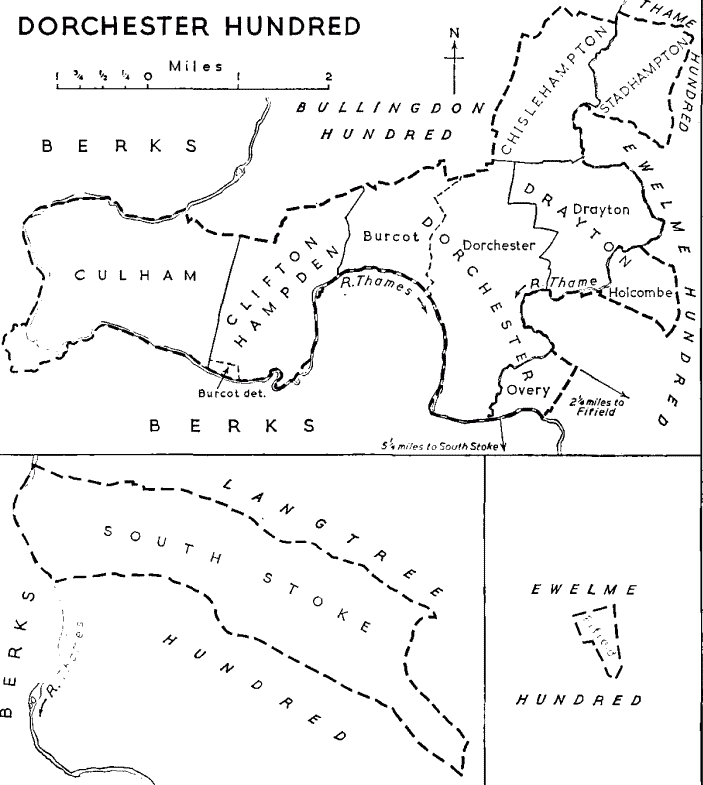
The Ancient Parish covered 1,288-acres, but its area was slightly increased in the 1870s as a consequence of the Divided Parishes Acts (1876–1882) and was given in the Census of 1891 as 1,301-acres. The increase is to be accounted for by the Inclusion in the Parish of Woodmead, the Riverside Pasture opposite the Village, where there had been for Centuries several small Detached parts of the neighbouring Parishes of Newington & Warborough as well as of Benson, Berrick Salome & Ewelme, which presumably represented early inter-Commoning arrangements. Most of the Parish lies in a large bend of the River Thame which forms the Parish Boundary for about 2-miles and separates Drayton from Warborough. Neither the Western Boundary with Dorchester nor the Northern Boundary with Chislehampton is marked by any distinctive features. About 300-acres of Drayton, Holcombe Grange, lie on the opposite side of the River.
Richard Davis’s Map Of Oxfordshire 1797
The Lower Section of the River Thame runs from the Town of Thame to its confluence with the River Thames just South of Dorchester-on-Thames: a distance of about 52-km. From Thame Town, the River flows broadly West past the Villages of Shabbington & Ickford to Waterstock. It then turns to the South now passing under the M40 & A40 Junction & Services at Wheatley, past Cuddesdon Mill & Chiselhampton, (where it is joined by the Chalgrove) before continuing on to Dorchester.
Except at Holcombe Grange the underlying Gault Clay is generally covered with Gravel & the Parish is remarkably Flat, the highest point (244-ft.) being on Primrose Hill South of the River. Apart from the Trees of the Village, the Riverside & Holcombe Grange, the only Woodland is the Copse to the North-west of the Village & this is recent: it is not shown on the Tithe Award Map of 1841 or the Ordnance Survey Map of 1881. Holcombe Grange is better Wooded than the rest of the Parish and its Timber is mentioned several times in the visitations made by the President & Fellows of Trinity College, Oxford. In 1769 298–Elms & Ashes were cut leaving 2,290-Trees standing. In 1811 the Timber was reported to be in Bad Order and arrangements were made for the Felling of about 900-Trees. In the 14thC ‘le Hurst de Draytone‘ is mentioned and this is probably the same as the Meadow to the North-east of the Village, which in 1841 was called the ‘Hurst‘. This suggests that the meaning here was not ‘Wood’ but ‘Bank‘. The Meadows along the River are liable to Flooding and the Fields of Drayton are traversed by many small Watercourses & Ditches the ‘Scouring’ of which, or rather the failure to do so, was one of the main concerns of the Manorial Court in the 17th & 18thCs.
Drayton-St-Leonard Parish Plan


During the 1990’s Haywards Bridge was dismantled in preparation to being brought up to European Standards, with a capacity to carry 32-tonnes. The dog-legs on each approach make the Bridge almost impassable for Long Vehicles. The rivetted Lattice Iron Girder Sides were removed and taken away for Sand blasting and re-Painting before being reinstated. The Brick & Stone Abutments were re-Built. The original Bridge Platform had consisted of RSJs spanning between the Abutments at about 3-ft centres, with the spaces between filled with Brick Barrel-vaulting. The new Bridge Bed consists of Reinforced Concrete Beams.
Map of the County of Oxford, from Actual Survey, by Andrew Bryant, in the year 1823. Inscribed by permission to the Right Honourable the Earl of Macclesfield, Lord Lieutenant, and to the Nobility, Clergy & Gentry of the County. (Click Zoom Button to enlarge)
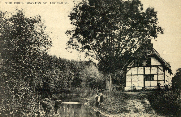
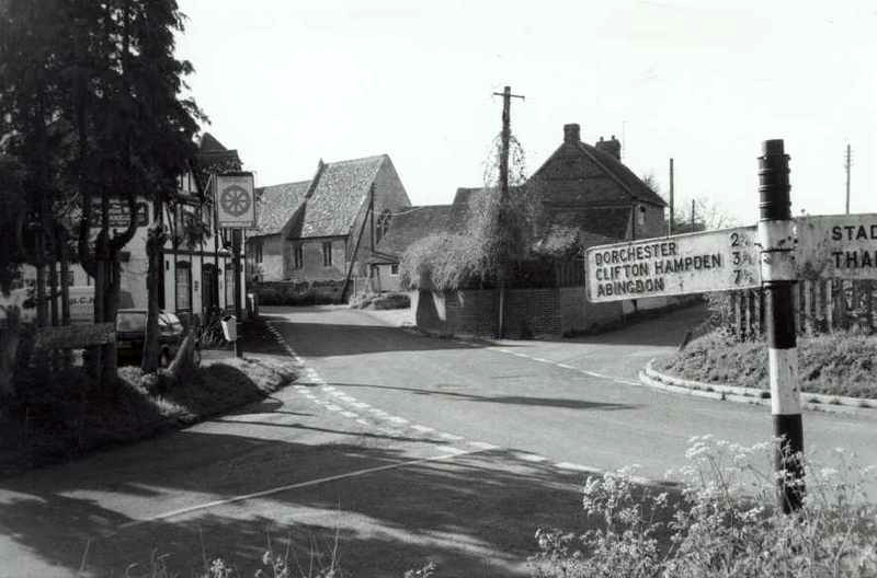
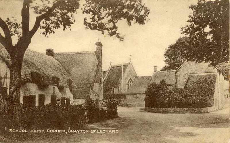
Two Metalled Roads lead out of the Village, one to Stadhampton across Haywards Bridge, the other West to Dorchester & Burcot. There are also 2 un-metalled Roads, 1-Leading to Chislehampton, the other across the River to Warborough & Newington. The River was formerly Crossed by 2-Fords. The lower of these, by the Village, remains un-Bridged but the other, Haywards, was Bridged in 1884 by Public Subscription. Before that there seems to have been a Footbridge at this Ford, certainly in 1841. There have been at least 2 other Footbridges. The one that remains, just above Lower Grange Farm, is a replacement of the Bridge marked at the same place in 1767. The other, just above the Ford, was Built after 1897 and was Washed away after 1948. The Village stands on the Right Bank of the River about 2-miles North-east of Dorchester. Its double name of Drayton St Leonard 1st appears in the Post Office Directory of 1847. Formerly it had been called Drayton-by-Wallingford. The new name, a natural one to adopt as the Church was dedicated to St Leonard, has been regularly used since 1847.


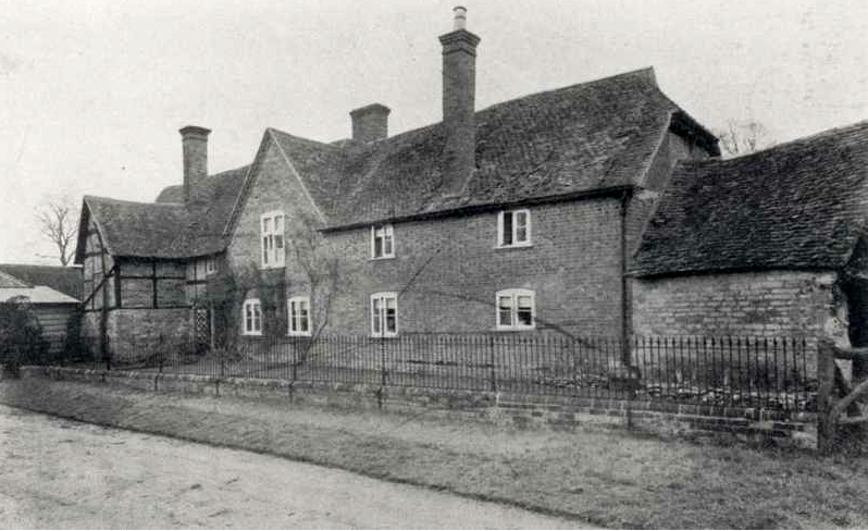
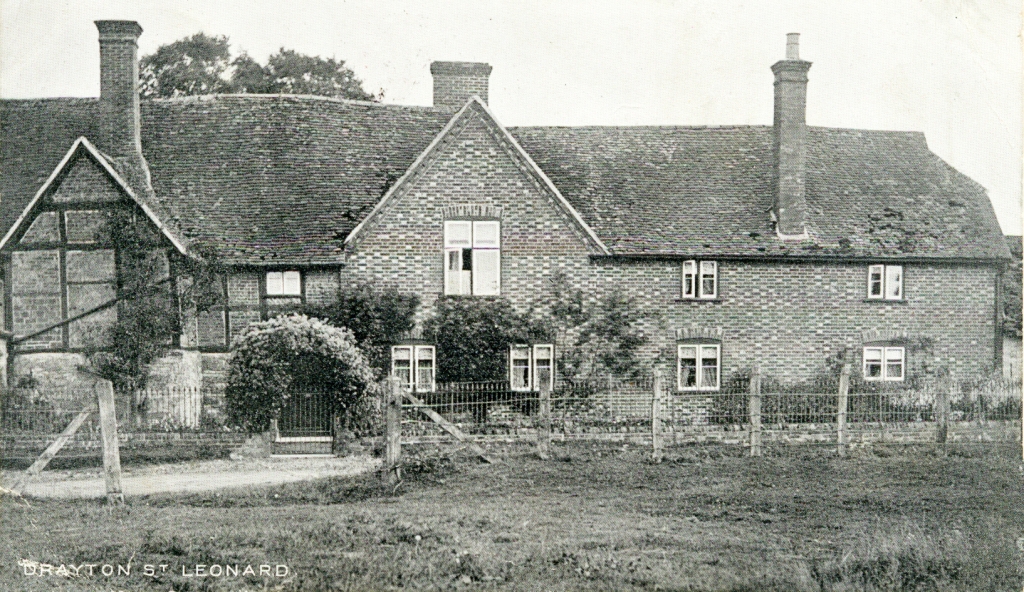
The Village covers a large area for the number of its Houses. Apart from the 8–Council Houses Built since 1945, most of Drayton lies between the Church & the River Thame. There are a remarkable number of old Houses. At least 15 were Built in the 16th or 17thCs, although in some cases there have been extensive later alternations & additions. The Hearth Tax returns of 1665 List 16-Houses with 1 to 7-Hearths, 5 of them having 5-Hearths or more. Most of the old Cottages are Timber-framed Buildings with Brick Infilling, and several are still Thatched.

The oldest seems to be the 16thC Garden Cottage by the River South-east of Drayton Manor Farm, but its neighbour, Little Garden Cottage, or Back Cottage, is not much more recent.

Other Cottages that are particularly worth noting are No.10 Water Lane, the Cottage in the Lane South of the former Rectory, Ford Cottage, White Cottage with its 5-small Dormers which in 1841 was divided into 3, and a little North of it a Cottage with some Herringbone Brick Infilling. Some, like Waterside House Cottage, have Old Tile Roofs. Other Cottages that are particularly worth noting are No.10 Water Lane, the Cottage in the Lane South of the former Rectory, Ford Cottage, Some, like Waterside House Cottage, have Old Tile Roofs.

Ford Cottage: House. Probably late-17thC. Stone Rubble & Brick Plinth; square-panel Timber-Framing with painted Brick infill; Thatch half-Hipped Roof; 2–Brick Stacks to left of centre, Brick Ridge Stack to right. Single Storey & Attic; 4-window Range. Plank Door with open Timber-framed Porch to left of centre. Irregular fenestration of Casements with Leaded lights. Swept Dormers to left & right. Gabled Dormer with old Plain-Tile surround and Roof to right of centre.
Interior – not inspected.

Tucked away at the end of the Lane passing through Drayton House Farmyard are 2-Ancient Houses, Waterside & Red Tile Cottage, and a massive Timber Barn. Some will remember this Barn as the Tithe Barn, or the Haseley Trust Barn. The Barn was in need of serious restoration having lain empty for many years during the 1950s & 1960s.

Waterside House was in 1841 a Private House and consists of a 16th–17thC House with modern additions. Its South wall is substantially built of Stone but the rest of the old House is Timber-framed with Brick filling. It has fine Stone Fireplaces, probably 17thC, on the Ground & 1st-Floors. Opposite its Main Front, there is a large Yew Tree. Red Tile Cottage & Waterside are 2-different Buildings, though until recent times (perhaps pre-1940s) the Cottage belonged to the Owners of Waterside, and at one Stage they Housed their Chauffeur there. The Garage they built for their Car’s is still just about standing.
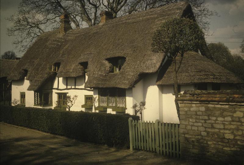
White Cottage, High Street: Probably early-18thC with 20thC addition to right. Painted render to Ground Floor, probably on Timber-framing; large Timber-framing to 1st-Floor centre; Thatch Roof; rebuilt Brick Ridge Stacks to left and right of centre. Single-Storey & Attic; 4-window Range. 20thC glazed Door to left. Irregular fenestration of Casements and 20thC Bays to Ground Floor. 4-swept Dormers.
Rear: Timber Framing to Ground Floor.
Interior: Open Fireplaces to Ground Floor & chamfered Spine Beams.

Although Timber-frame with Brick filling is the commonest type of Structure for the older Cottages there are a few in Stone. With the exception of Waterside House, Red Tile Cottage & the Old Rectory all the Larger Houses in the Village are, or were formerly Farmhouses. The 2-Farms in the Modern Village have Houses that were greatly extended in the 19thC.

While Drayton Manor Farm is an enlargement of an Old but not very distinguished Building, Drayton House Farm is an enlargement of a well-proportioned early-18thC House of which a Chimney Stack and a finely Panelled Room survive. Between these Farmhouses is a House, now divided in 2, which was formerly called Drayton Farm although it now takes its name, Guys House, from a Tenant J H Guy, who Farmed from it in the early part of the 20thC. It is a Timber-framed Brick Building on a Rubble Base. The White House, also a Farmhouse in the mid-19thC, is Stone-built and consists of a 17thC Block with a Wing added in the 18thC.

Ford Cottage, a House South of White House (which has since disappeared) although some of the Farm Buildings have survived, and Manor Cottage (formerly Nutts) were also Farmhouses in 1841.
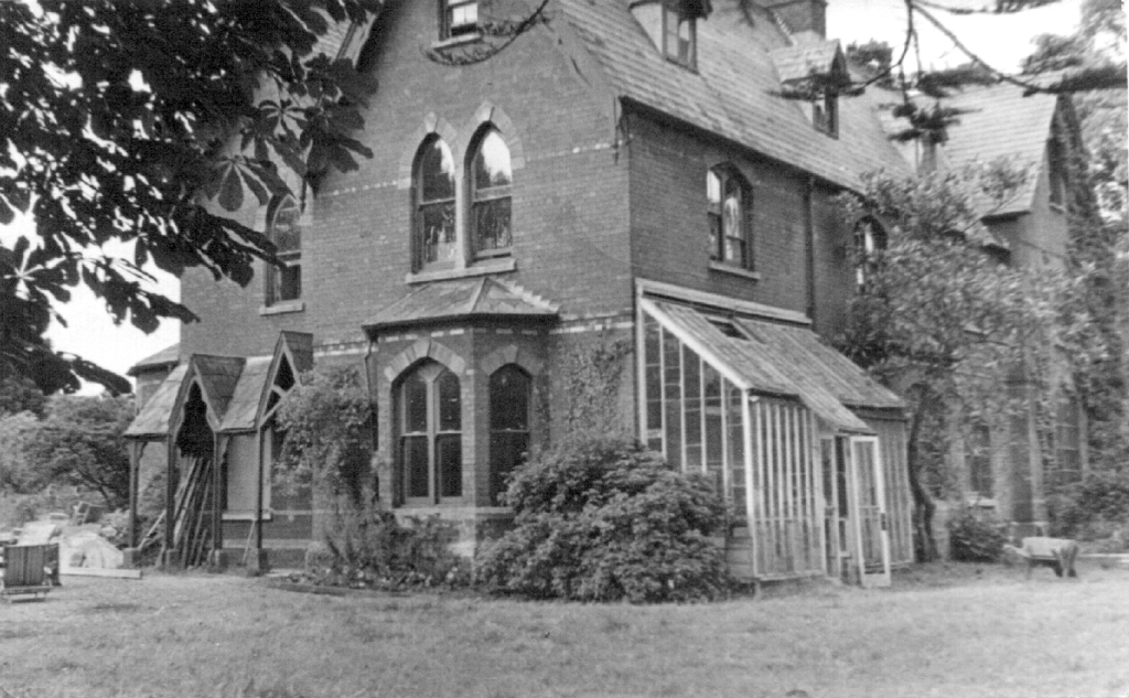
The Rectory, now a Private House called ‘Furlongs‘, was Built by the Rev A J Williams in 1862 at a cost of more than £1,200 and was later Enlarged. There are clear traces of an earlier Building, shown on the Tithe Award Map, but this was not the earlier Curate’s House, which stood on the Road South of the Church. The Old Rectory was Sold into Private Ownership after WW2, was Designed by the Architect John Billing & Built in 1862


The White House, Water Lane, Drayton
Mid-17thC, with early-19thC addition to Front right. Coursed Stone Rubble with Ashlar Stone Dressings to Main Block; coursed Stone Rubble with Brick Dressings to 19thC addition; Old Plain-tile Roof, Hipped above addition; Brick End Stacks. 2-Storeys & Attic; 3-window Range. Plank Door to left return of addition. Irregular fenestration of 19thC Wood Casements with Brick surrounds. 16-pane unhorned Sashes to addition. Gabled full Dormer to Centre.
Interior: 19thC straight Flight Stairs from Ground to 1st-Floor, mid-17thC Winder Staircase from 1st-Floor to Attic. Double Queen-post Roof construction: Brick chamfered Arched Fireplaces to 1st-Floor and to Ground Floor left. Open Fireplace to Ground Floor right.
Former Drayton Farm (Guy’s House)
Mid-15thC, with 17th & 19thC Alterations. Rubble Stone & Brick mixture Plinth; large Timber-Framing with rendered Infill; old plain-Tile Roof; Brick End Stack to left; massive Stone lateral Stack to Rear centre. 2-Storeys & Attic, 6-Bay, 6-window Range. 20thC glazed Door to 17thC Timber-framed Gabled Porch to Centre. Irregular fenestration of late 19thC casements. Raking Dormer of 4-lights to left of centre.
Rear: Plank Door to left of Centre. Central lateral Stone Stack of un-coursed squared Stone with Flint Garreting. 9-light wood mullion & transom window to right. Two 4-light wood mullion & transom windows projecting on coved wood Lintels to 1st-Floor left. 19thC Casements inserted in remains of 2 similar windows to 1st-Floor right.

Interior: 17thC Open-well Newel Stair from Ground to 1st-Floors with wooden Baluster Balustrade, moulded handrail & turned Acorn Finials to Newels. Straight Flight Stairs from the 1st-Floor to Attic. Arch-braced Collar-truss Roof with 2-Rows of Windbraces. Massive Open Fireplace to Ground Floor Centre. Stone Tudor–Arched Fireplace with Moulded Surround to Ground Floor left. Spine Beams have Angle Bracing.

The oldest & most interesting Secular Structure in the Village is the Barn which is alternatively called the Haseley Barn, because it was formerly owned by the Great Haseley Trustees, and the Tithe Barn, although there is no evidence, other than its age, to support such a Title. It is a Timber-framed, Weather-boarded Building of 6-Bays with a Hipped & Tiled Roof which is carried down over Aisles on all 4-Sides. This Barn is certainly no later than the 15thC and may have been Built towards the end of the 14thC. There are several groups of fine Farm Buildings, some Thatched, the most noteworthy being those of Drayton House Farm, Drayton Manor Farm and the Cart-Shed opposite the White House.
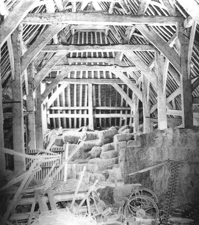
The Barn now houses the Aston Martin Heritage Trust Archives & Museum. In the Conversion for this purpose, they have added a Mezzanine Floor, has been inserted at one end to House Offices.
Drayton St Leonard Zoomable Map
In Holcombe Grange, there are 2-Outlying Farms, and there were Houses on these Sites in 1597. In a Survey of that Year, Lower Grange Farm is called the Site or Capital House of Holcombe Grange. The present House is a Timber-framed Brick Building on a Base of Stone & Brick. To the North a very large Stone Chimney projects and either side of this there are fine windows, including one of 18-Lights under a Pent Tile overhang. This House, in many ways the most interesting in the Parish, also has a very good South Porch and a 17thC Staircase. Upper Grange Farm is basically a 17thC Building and has a 17thC Panelled Hall. Until it was recently covered, there was a dated Stone visible bearing the date 1668.
Upper Grange: House. Early-17thC with 20thC Alterations. Red Brick to Ground Floor; close studding to 1st-Floor with 19thC Brick infill; old plain-tile double depth Roof; massive Brick End Stack to right. Double-depth Plan. 2-Storey, 3-window Range. 20thC Sash. Door to left. 20thC 4-light Casement to right. 3 eight-pane 20thC horned Sashes to 1st-Floor.
Interior: reported to have 17thC Panelled Hall & Staircase.
The Topography of the Village can 1st be Studied in the Tithe Award Map of 1841, and thereafter with the Aid of Ordnance Survey Maps and the numerous Sale Catalogues, it would be possible to trace in detail most of the changes in the Layout of the Village. Before the 19thC it is not possible to do this. There are occasional mentions of particular Houses, for example, Mr Yates’s House called Pawlings, mentioned in 1574, which cannot now be identified. Nor is it possible to identify the Fields & Lands mentioned in early Deeds & Surveys, although the Tithe Award Map gives many names. Among those which can be traced back is Lower Shilfield Furlong, which is almost certainly the 14thC ‘under schulfull’, and Waterslade which occurs in this form in the 15thC. The Village and its Fields were in the 17th & 18thCs divided into 2-Ends: the Eastern part was Town End, the Western was Farm End. In the Tithe Award the Riverside Meadows above the Village are described as Town End Mead and those below the Village were called Farm End Mead. In the early-17thC the ‘whole Farme End of Drayton‘ was presented for failure to observe the Ancient Custom of Perambulation (walk around the Manor) and in 17th & 18thC Leases Lands & Houses are often described as being in Town End or Farm End.

There were 2-Public Houses in the Village, the ‘Catherine Wheel‘ and the ‘Three Pigeons‘. In 1841 the only Licensed House was the ‘Catherine Wheel‘, which was then in what is now called Garden Cottage (See Below). In 1805 this House was Insured as the ‘Catherine Wheel‘. Sometime after 1841 the Licence & Name were transferred to what in 1841 was the Smithy, and this was probably done by William Townsend who in 1847/48 was both Blacksmith & Licensee of the ‘Catherine Wheel‘. The Modern Public House replaced a group of old Cottages as below.


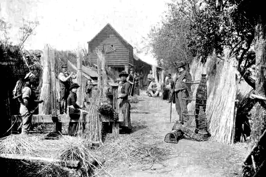
Osiers: is a loose term covering a number of Species of Willow (Salix), which can be Coppiced. Traditionally, most Lowland Villages had Osier Beds, the Harvest of which would be used for making Basket-work, Eel Traps, Thatching Spars, Firewood & Fencing. Although they are often associated with Rivers & Meadows, Osiers in fact grow best on well drained Land, although they will not tolerate extremely dry conditions.

The Willow for Basket-making is harvested annually, usually during the Winter months before the Sap starts to rise in the Spring. The Osiers are cut using a heavy-backed Sickle Hook, and an experienced Cutter can Harvest up to 40–50 bundles per day. As the demand for Fruit grew throughout the 2nd half of the 19thC, so too did the demand for Willow Baskets to Store & Transport it. Osiers need to be planted in January or February in well cleared Land in Trenches up to 20-ins deep & 12-ins apart and can grow anything up to 18-ins a week in Season. There is no Covert which Pheasants like so much as Osier-Beds, especially if they are near water.
RAF Mount Farm: Originally a Grass Airfield Satellite for the RAF Photographic Reconnaissance Unit at nearby RAF Benson, Mount Farm was Built in 1940/41. It had 3-Concrete Runways, 49-Dispersals (24-Concrete Pan Type plus 25-PSP Squares) & 8–Blister Hangars. The 13th Photographic Squadron of the 8th USAAF moved in during February 1943, and its Parent 7th Photographic Group was Established at Mount Farm in July 1943. Handed back to the RAF in May 1945, the Station was inactive and used temporarily by the Ministry of Supply for ex-War Department Vehicle Sales. The return to Agriculture began in 1949 and the Airfield was Sold for Farming in 1957. Part of the Site was then bought for Gravel Extraction in 1961, and most of the Concrete was lifted for Hardcore. During 1960-62, the New Village of Berinsfield was Built on the Western end of the Site, where RAF & USAAF Wartime Buildings had been Located.

Herbert William Parry, Sergeant 1181625 19th June 1941 Royal Air Force Volunteer Reserve. Aged 19-yrs, Parry was Flying at Night in a Wellington Bomber practising Circuits & Landings. His Aircraft Overshot the Runway at RAF Mount Farm Aerodrome, near Dorchester, Oxfordshire & Crashed at Drayton St Leonard, with the Loss of the entire Crew. Sgt Parry was from Isleworth and was Based on No.12 OTU from RAF Benson and his fellow Crew were: Sgt Kenneth Turner Mitchell, from Falkirk; Sgt Howard Ursell from Hampton Middlesex & Sgt Leslie Owen Hodnett from Stourbridge.


Mount Farm – Originally intended to be named Dorchester, Mount Farm was identified as a suitable Satellite Site for RAF Benson, but with Hard Runways. It was used by Fairey Battles of 12-OTU from July 1940, before Completion and the Runways were not completed until November.
The Single-Engined Fairey Battle was a 3-Seater Merlin-powered Light Bomber which went into Wartime Service with the Allied Expeditionary Force in France. It proved to be nothing more than a Death-trap for its Crews; slow, poorly armed & with a negligible Bomb Load. Used for Bombing & Dive Bombing, Members of 12 Sqaudron were the 1st Airmen to win the VC in a Suicidal Attack on the Maastricht Bridges in May 1940. After the Fall of France, the Squadrons Flying Battles were quickly re-equipped, and the Aircraft devolved down to be used as for Flying & Gunnery Training. Many Air-Gunners who later served on the “Heavies” learned their Trade from the draughty, rearmost open Cockpit of a Fairey Battle.
The Battles gave way to Vickers Wellington Bombers in December and with Benson waterlogged Mount Farm was Busy. It was Bombed in January & May 1941 and in July, as Benson had dried out, it became a Satellite of Harwell and was used by 15 OTU Wellingtons returning to Benson’s care in January 1942. With the increase in Photographic Reconnaissance Activity at Benson 140-Squadron moved in for a time, during which it undertook Reconnaissance for the Dieppe Landings in May 1942. In February 1943 the Americans moved in with the 1st of 4-Squadrons of Lightning & Spitfire Reconnaissance Aircraft for the 7th-Photo Reconnaissance Group and several Light Types to transfer Films to their Customers. The Units were heavily occupied in the Lead-in to D-Day and subsequent Actions but left for RAF Chalgrove in April 1945. The RAF then stored Surplus Vehicles for a time but the Airfield reverted to Agriculture and subsequently Gravel Extraction.

I saw this amiable American sitting on a Harley Davidson Motorbike off Church End in Ford Lane. He had an MP Armband on which to me looked quite impressive, so was that Motorbike. I think he was looking for his woman friend, who was apparently not at home. We kids would shout after US Army Lorries passing slowly through the Village – ‘got any gum chum!’ and often packs of chewing gum & candy would come hurtling from out of the back. There were 2-Pubs, The Catherine Wheel and opposite the Church, The Three Pigeons. Both increased their Trade with the presence of the Americans at Mount Farm. The Sky was full of Aircraft. It was said that Oxfordshire was a virtual Airfield with Dromes all round our tiny Drayton Village. Benson, Abingdon, Chalgrove to name a few. One day I saw a P47N Thunderbolt Fighter trailing smoke go in to Land at Mount Farm. Others came and went.
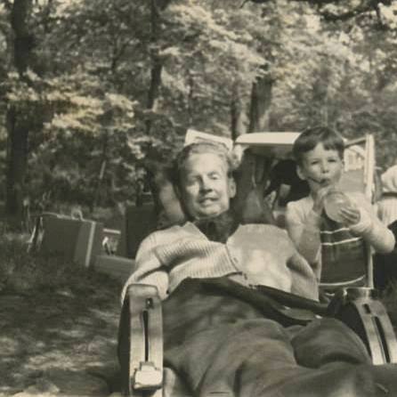
Robin Francis Cavendish, MBE (12th March 1930 – 8th August 1994), was a British Advocate for Disabled people, Medical Aid Developer, and one of the longest-lived Responauts in Britain. Born in Middleton, Derbyshire, Cavendish was affected by Polio in Kenya at the age of 28. Despite being initially given only 3-months to live, Cavendish, paralysed from the neck down and able to breathe only with the use of a Mechanical Ventilator, became a tireless Advocate for Disabled people, instrumental in organising the 1st Records of the number of Responauts in Britain and helping to develop numerous Devices to provide Independence to Paralysed people. In 1962, Cavendish and his friend Teddy Hall, the Oxford University Professor, developed a Wheelchair with a built-in Respirator that freed Cavendish from confinement to his Bed, which became the Model for future devices of its Type, with Cavendish eventually using a Total of 10-different Chairs. Determined that Mobility should be available to other Polio Survivors, Cavendish raised money from the Ernest Kleinwort Charitable Trust for the 1st 12–Chairs, and eventually persuaded the then British Department of Health to Fund a Series of Chairs, which were Manufactured by Teddy Hall’s Company, Littlemore Scientific Engineering (ELSEC). This part of Cavendish’s life is shown in the 2017 Film Breathe.
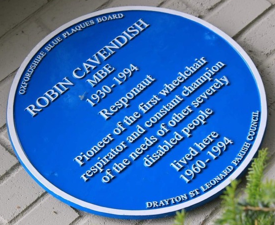
After Testing them on himself, Cavendish helped to Market pieces of Equipment that improved the quality of life of Disabled people. Most notable among these was the Possum, which Cavendish developed with Scientists at Stoke Mandeville Hospital, and which allowed users to use the Telephone, turn on a Television or adjust a Home’s Central Heating with only a left-or-right movement of their head. Others included a lightweight Ventilator that ran on Batteries, and a modified Aircraft Seat fitted with Electronic Aids. Littlemore received Government Funding to make another 40-Chair-&-Ventilator Sets. Moved by the plight of Families who could never go on holiday together, Cavendish and others, in particular Polio Specialist Dr G T Spencer, the Consultant in charge of the Lane-Fox Unit at St Thomas’s Hospital in London, co-Founded the Charity Refresh in 1970 to raise the money toward the Construction of Netley Waterside House, a Holiday Complex overlooking Southampton Water on the South Coast whose Facilities provided for the care of Severely Disabled Responauts as they and their Families enjoyed the attractive surroundings. The Facility Opened in 1977.
