File:Mapa COL.PNG
Jump to navigation
Jump to search

Size of this preview: 744 × 600 pixels. Other resolutions: 298 × 240 pixels | 596 × 480 pixels | 917 × 739 pixels.
Original file (917 × 739 pixels, file size: 154 KB, MIME type: image/png)
Captions
Captions
Add a one-line explanation of what this file represents
| Description |
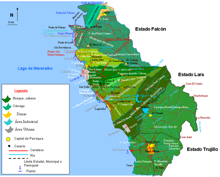
Español: Mapa de la Costa Oriental del Lago una Subregión del Estado Zulia, Venezuela |
||
| Date | |||
| Source | Own work | ||
| Author | Andrés González | ||
| Permission (Reusing this file) |
|
File history
Click on a date/time to view the file as it appeared at that time.
| Date/Time | Thumbnail | Dimensions | User | Comment | |
|---|---|---|---|---|---|
| current | 13:01, 6 January 2011 | | 917 × 739 (154 KB) | Andrés González (talk | contribs) | Mapa de la subregión Costa Oriental del Lago del Estado Zulia, Venezuela |
| 14:30, 5 January 2011 |  | 5,262 × 4,646 (2.02 MB) | Andrés González (talk | contribs) | {{Information |Description={{es|1=Mapa de la Costa Oriental del Lago una Subregión del Estado Zulia, Venezuela}} |Source={{own}} |Author=Andrés González |Date=2011-01-05 |Permission={{PD-self}} |other_versions= }} [[Category |
You cannot overwrite this file.
File usage on Commons
There are no pages that use this file.
File usage on other wikis
The following other wikis use this file:
- Usage on es.wikipedia.org