ORIENTAL MINDORO: An Emerging Eco-Tourism Destination

Puerto Galera: It’s More Fun in the Philippines (source)

Oriental Mindoro is shaped as an inverted-J south of the Luzon island. It is graced with some of the Philippines’ most beautiful naturescapes. There are many beaches to pick from, from the colors powdery white to fawn beige. Aside from that, experience oneness with nature with their beautiful mountains, lakes, rivers, rain forests, wild animals, rare flora and fauna, and pocket communities of the existing ethnic groups. Throughout the years, Oriental Mindoro has maintained its rustic, agrarian location.

The Province of Oriental Mindoro is predicted to be Philippines’ emerging eco-tourism destination. In 2005, the Philippines was found to be the center of marine fish biodiversity and the home of the most diverse marine ecosystem all over the world. Most of the endemic species in the Philippines are found in the Verde Island. The passage houses 2,983 individual species of algae, corals, crustaceans, mollusks, fishes, marine reptiles, and marine mammals (based on a study conducted by scientists Carpenter and Springer in 2005).

White Beach Resort, Puerto Galera (source)

Oriental Mindoro is famous for Puerto Galera, which is graced with topnotch quality of natural harbors. Known as the “Pearl of Mindoro“, it’s no doubt for its popularity all over the globe for its splendid beaches, coral reefs, and exquisite dive sites for new and experienced divers alike. Active water sports such as scuba diving, snorkeling, and swimming is also very abundant in these parts.

Aside from these lovely activities stated above, there are countless numbers of special interest tours a tourist can engage on: from mountain climbing to trekking, hiking, camping, butterfly watching, game fishing, and adventure trips to the wilderness. Visit the locals or the Mangyans, and you shall find it absolutely pleasing to engage in exploring natural caves, captivating waterfalls and island hoppings.


FAST FACTS ABOUT ORIENTAL MINDORO

  • CAPITAL: Calapan City

    File:Vlag Fil Oriental.gif

    Flag of Oriental Mindoro (source)

  • 30th largest province in the Philippines
  • The Halcon mountain range (4th highest peak in the Philippines) runs from north to south and serves as the province’s natural boundary with Occidental Mindoro.
  • FOUNDED ON: June 13, 1950 (from Republic Act No. 505, An Act to Create the Provinces of Oriental Mindoro and Occidental Mindoro)

    File:Provincial seal of Oriental Mindoro.png

    Seal of Oriental Mindoro (source)

  • TOPOGRAPHY: Varied and dominated by rugged mountain ranges on the west and fertile valleys towards the eastern coast
  • LAND AREA: 436,470 hectares
  • POPULATION: 785,602 (2010 census)
  • LANGUAGE: Tagalog (predominant dialect), Ilocano and Cebuano, Strains of the Mangyan dialect (Arayan, Alagnan, Buhid, Hunuo, and Tadyawan) The working population can read and speak Filipino and English
  • CLIMATE: Has no distinct wet or dry seasons but is open to southwest monsoons and typhoons; experiences maximum rainfall during the month of June to October. Relative humidity is registered at 81%

LOCATION

Oriental Mindoro lies on the eastern part of the island of Mindoro. It is located 15 km off the southwest coast of Luzon. It’s bounded on the north by Verde Island and the Verde Passage, on the east by Maestro de Campo Island and Tablas Strait, on the south by Semirara Island near Pandarodan bay, and on the west by the province of Occidental Mindoro.

Oriental Mindoro’s coordinates are: 13°00′N 121°05′E


POLITICAL SUBDIVISIONS

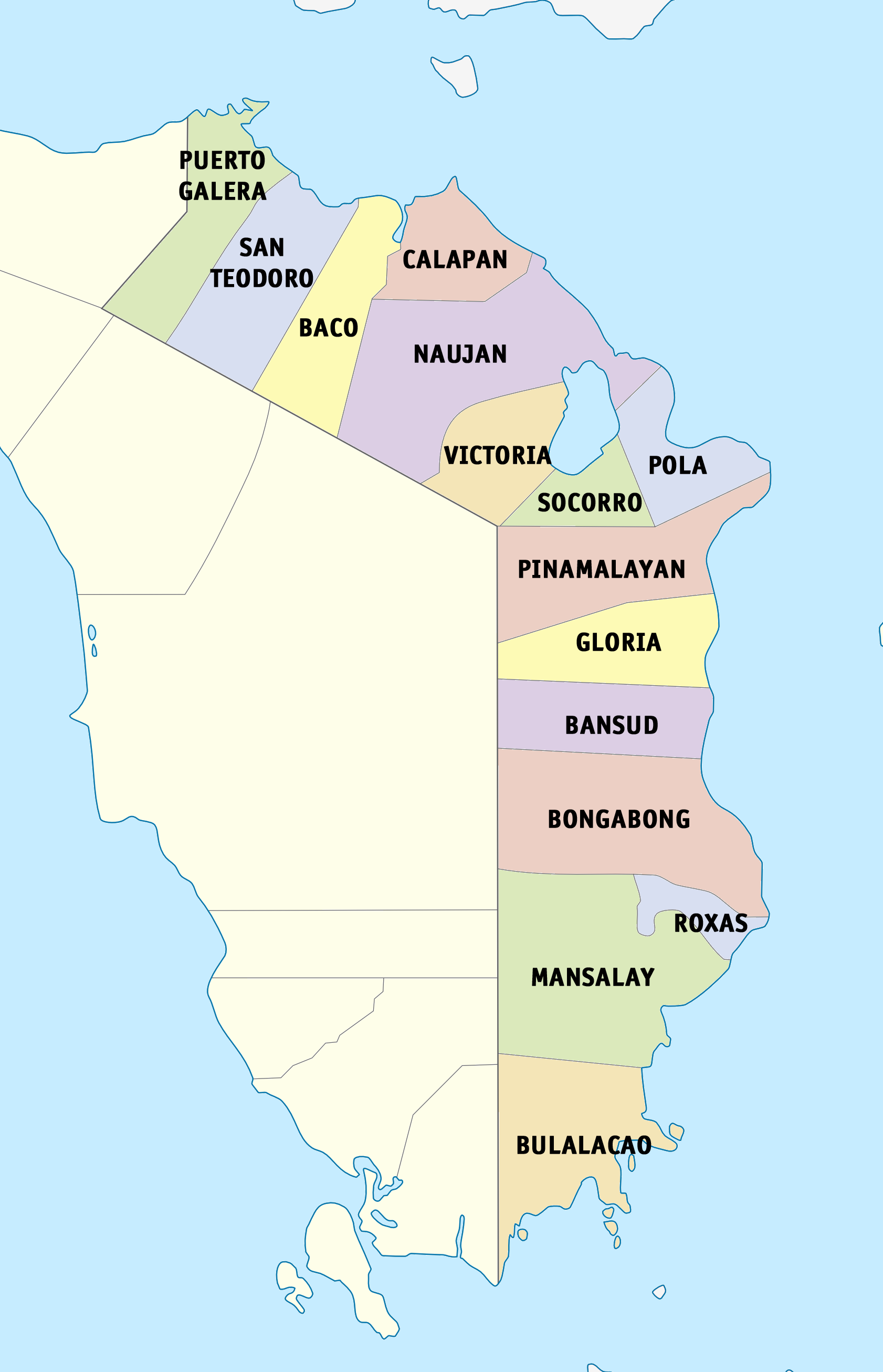
Map of Oriental Mindoro (source)

1 COMPONENT CITY: Calapan City

14 MUNICIPALITIES

  1. Baco
  2. Bansud
  3. Bongabong
  4. Bulalacao
  5. Gloria
  6. Mansalay
  7. Naujan
  8. Pola
  9. Pinamalayan
  10. Puerto Galera
  11. Roxas
  12. San Teodoro
  13. Soccoro
  14. Victoria

HOW TO GET THERE

  • BY AIR

Private/commercial aircraft and government including military craft landed in Calapan airport. Pinamalayan airport which opened just a few years ago is now non-operational. Private airport is being operated in the municipality Naujan Sea.
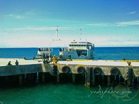
  • BY SEA

Ro-Ro Vessel at Calapan Pier, Oriental Mindoro (source)

Calapan port in Calapan City and Dangay port in Roxas are the two national ports of entry in the province servicing 20 cargo Vessels and 20 fastcrafts by 7 shipping companies)

DAILY DEPARTURE ARRIVAL OF VESSELS IN CALAPAN CITY-VICE VERSA

STARLITE SHIPPING LINES

 1:00 AM  Atlantic
 3:00 AM  Navigator
 5:00 AM  Annapolis
 7:00 AM  Polaris
 7:00 AM  Nautica
 11:00 AM  Navigator
 1:00 PM  Annapolis
 3:00 PM  Polaris
 5:00 PM  Atlantic
 7:00 PM  Nautica
 9:00 PM  Annapolis
 11:00 PM  Polaris
MONTENEGRO SHIPPING LINES

 12: AM  Helena
 2:00 AM  Natasha
 4:00 AM  Feliza
 6:00 AM  Lolita
 8:00 AM  Teresa
 10:00AM  Natasha 
 12:00 noon  Helena
 2:00 PM  Zenaida
 4::00 PM  Feliza
 6.00 PM  Lolita
 8:00 PM  Teresa
 10:00 PM  Natasha
BALENO SHIPPING LINES

 9:30 AM  Baleno 5
 11:30 AM  Baleno 8
 3:30 PM  Baleno 5
 1:30 PM  Baleno 8
SUPER CAT 

 Calapan  Batangas
 5:00 AM  6:30 AM
 8:00 PM  9:30 AM
 11:00AM  12:30 PM
 2:00 PM  3:00 PM
 5:00 PM  6:30 PM

DANGAY PORT VIA CATICLAN AND ROMBLON

 STARLITE SHIPPING LINES  MONTENEGRO SHIPPING LINES  MV MITCHELLE MV MAHARLIKA
 7:30 AM Voyager  10:30 AM Oliva  Going to Romblon         7:30 PM
  6:30 PM Rebecca   twice a week

(source

  • BY LAND

Land transport within the province is facilitated by public utility vehicles (jeepneys, buses, minibuses) and L-300 vans. A number of vans offer door-to-door direct transport and cargo services from some of the municipalities to Metro Manila. PUVs and tricycles serve passengers within short distance trips or just within the town proper.

Travel to-and-from the southern Philippine islands was made easier with the opening of Strong Republic Nautical Highway in 2003 – one remarkable project proudly conceptualized and proposed by the Mindorenos. This even offered convenience and shorter access primarily to the world-famous Boracay, where guests may take the “Isang Sakay na Lang” via Manila-Calapan-Roxas route. And with the SRNH in full operation, Oriental Mindoro is regarded as the “ultimate bridge” that connects mainland Luzon with the Visayas-Mindanao group.

(source)


SOURCES


Keep updated with more news and facts about Oriental Mindoro by following this blog!

 ✽ STAY TUNED FOR MORE! ✽

MARINDUQUE: The Literal Center of Attention

Moriones Festival (source)

Moriones Festival (source)

To be able to function, a human and an animal need to have a heart amongst everything important in the body. Perhaps it is the most vital. Lo and behold, even the Philippines has a heart!

Proclaimed as the Heart of the Philippines because of its literal heart-shape, Marinduque is also the geographical center of the Philippine Archipelago! Marinduque is best known for the Moriones Festival (image above) done every Holy Week. This age-old tradition goes to show the deep devotion of the believers of the Catholic faith by re-enacting what was done to Jesus Christ by whipping their backs, arms, and legs as an act to receive forgiveness for their sins.

Putong: "The Crowning" (source)

Putong: “The Crowning” (source)

This is just one of the reasons to visit Marinduque. There’s also the beautiful natural attractions and beaches, native craftsmanship, scrumptious delicacies, and of course the warm Filipino hospitality magnified here is known as putong: a traditional welcome ritual, steeped in color and mirth, performed through song and dance; it is only found in Marinduque!

Continue reading

OCCIDENTAL MINDORO: Marine Wonderland

The beautiful Apo Reef in Sablayan, Occidental Mindoro (source)

The beautiful Occidental Mindoro is blessed with much marine exquisiteness from its pristine white sand beaches, immaculate forests, isles and islands full of marine life, mysterious caves, graceful waterfalls, and a rich garden of corals. It is a sublime vista for divers and adventurers alike, with so much to offer from its unexplored shoals and atolls. Areas around Ambulong Island, Ilin Island, White Island, and Pandan Grande offer a fertile diving ground surrounded by exquisite coral reefs and colorful marine life, ranging from exotic fish to exquisite seashells.

The residents of San Jose, Occidental Mindoro celebrates the Saknungan festival every 25th to 27th of April. It is a 3-day thanksgiving festival highlighted by streetdances and parades. Saknungan is a Mangyan term that means “bayanihan” or the spirit of cooperation, brotherhood, and unity at work. It is the spirit portrayed by the Mindoreños day-to-day, especially during the planting and the harvesting seasons.

Saknungan Festival in Occidental Mindoro (source)


FAST FACTS ABOUT OCCIDENTAL MINDORO

  • CAPITAL: Mamburao

    Flag of Occidental Mindoro (source)

  • 17th largest province of the Philippines
  • The Halcon mountain range (4th highest peak in the Philippines) runs from north to south and serves as the province’s natural boundary with Occidental Mindoro.
  • FOUNDED ON: June 13, 1950 (from Republic Act No. 505, An Act to Create the Provinces of Oriental Mindoro and Occidental Mindoro)
  • TOPOGRAPHY: generally rugged, with narrow strips of coastal lowlands; terrain is characterized by successive mountain ranges, valleys, and elongated plateaus, with rolling lands along the coastal region

  • LAND AREA: 588,350 hectares
  • POPULATION: 452,971 (2010 census)
  • LANGUAGE: Tagalog is spoken by 69.78 percent of the people. Other dialects are Ilokano (10.63 percent), Hiligaynon (6.47 percent), and Kinaray-a (5.84 percent). The working population can read and speak Filipino and English.
  • CLIMATE: Dry from November to April and wet during the rest of the year. Average annual volume of rainfall is 2,000 mm. Temperature is from 30.7°C to 16.4°C.

LOCATION

The Mindoro island is separated by a mountain range in the middle that serves as a natural and political boundary between the two provinces of Occidental and Oriental Mindoro. Occidental Mindoro occupies the western part of the island.

To its west is the Apo East Pass, and on the south is the Mindoro Strait. Oriental Mindoro lies at the eastern half. The South China Sea is to the west of the province, while Palawan is located to the southwest, just across Mindoro Strait. Batangas is at the north, separated by the Verde Island Passage.

A Map of Occidental Mindoro (source)

Occidental Mindoro’s coordinates are 13°00′N 120°55′E


POLITICAL SUBDIVISIONS

11 MUNICIPALITIES

  1. Abra de Ilog
  2. Calintaan
  3. Looc
  4. Lubang
  5. Magsaysay
  6. Mamburao
  7. Paluan
  8. Rizal
  9. Sablayan
  10. San Jose
  11. Sta.Cruz

HOW TO GET THERE

  • BY AIR

Travel takes 45 minutes from Manila to San Jose via Philippine Air Lines, Cebu Pacific and Sea Air

  • BY SEA

Travel takes 2 1/2 hours from Batangas City Pier to Abra de Ilog Pier, while from Batangas

A Roro Ferry docked at the pier in Occidental Mindoro (source)

City Pier to San Jose it takes 12 hours via Roll-on, Roll-off (RO-RO) vessels of the Montenegro Shipping Lines and Besta Lines

  • BY VEHICLE (Land-Sea-Land)

Travelers can also choose to hire a door-to-door van. It will pick you up from your home and drop you off to your destination. (via RO-RO vessels)

Another option is to take a the bus (via Dimple Bus) which has a terminal in Cubao. This bus is traveling from Manila to San Jose via Mamburao City.


SOURCES


Keep updated with more news and facts about Occidental Mindoro by following this blog!

 ✽ STAY TUNED FOR MORE! ✽

ROMBLON: More Than Marble

Marble Statues

Marble Statues in Romblon (source)

Most famous for their marble sculptures, Romblon is steadily becoming one of the favorite provinces that tourists, be it local or international, choose to go. They owe their marble-making industry to 1950’s Italians and up until now it has made their province unique. But that’s not all there is to it.

Bonbon Beach, Romblon

Bonbon Beach, Romblon (source)

The beaches in Romblon are everything Boracay was before: with powdery white sand, pristine surroundings, and the feeling of having the entire place to yourself, you will feel like you have traveled to the past. With nearly zero crime rates, legendary hospitable people, and undiscovered and unspoiled natural attractions, Romblon is the place to be away from the stress of the city.

Continue reading

PALAWAN: The Last Frontier

Famous for its Underground River, located in Puerto Princesa Subterranean River National Park

Palawan truly made its way into being a household name for domestic travel. “The Land of Beautiful Safe Harbor,” once it was called for the island was a dock for merchant ships sailing in the old times.In current times, it takes on a new purpose as “The Land of Promise.”

Palawan is popularly known for being nature travelers’ sublime haven, providing refuge and oneness with the environment. It has been hailed as Philippines’ cleanest, greenest and most peaceful city. Adding up to that, Palawan has been named as the “Last Ecological Frontier” for its unique ecological balance. The locals (called as Palawenos) are also very serious about environmental protection and conservation, although being hospitable and warmhearted to tourists.

Continue reading