| Distance | 1.42 mi |
| Elevation Gain | 325 ft |
| My Time | 42 min |
| Difficulty | Moderate |
| Closest Town | Del Norte |
| Food Nearby | Carthers Roadhouse |
Hiking Colorado’s Natural Arch, La Garita Arch
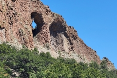
Colorado’s Natural Arch, La Garita Arch is located in the Rio Grande National Forest near the towns of Del Norte and La Garita. According to the Forest Service, this arch was formed from lava flow. While not the only arch in Colorado, this arch is pretty accessible in southwestern Colorado.
Getting Started
The hardest part of finding the arch is taking the roughly ten miles of dirt roads to find the parking area. The roads are in fairly good shape and most cars should be able to handle them. From the parking area you are already at the arch that resembles the number zero in shape. La Garita Arch is in a rock formation that starts a spine like shape through the arid landscape.

When I got to the trailhead there were a couple of people who were making their way up to the arch itself. I decided against that but instead took the trail that follows the line of the rocky spine and away from the arch. The trail from the start is narrow dirt strip that cuts through the rocky soil and small trees and heads uphill pretty quickly.

Up the Hill
As you begin to traverse up the hill, the arch starts to take a bit more of a cave like feel. The new perspective of the arch shows how deep the arch cuts through the rocky surface before slipping out of view as the incline get a little greater.

The trail continues to on a consistent 12-14% grade uphill grade for the entire six tenths of a mile to the top. While not technically challenging, the incline can be a problem for those who aren’t used to uphill hikes. Other than the incline, the trail is pretty unremarkable until you get to the top of the hill.
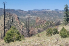
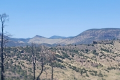
From the top of the hill the land really opens up in front and behind you. The rolling hills and mesas of the Rio Grande area in full view from the top. There was also some trash and remnants of old fires and I wonder if this location is one that is used for local entertainment.

Lost Trails
From the landing on top of the hill the trail is supposed to continue to get a better view of the spine that continues on the next hilltop. I tried to follow the trail as best I could but the lightly used area was too hard to find, even with mapping software. I found myself getting closer to what looked like untouched land and didn’t want to to mess with the plants in the area.

Instead I went back to the landing area that was well used and enjoyed the views of the land around. The spine running down the northern hill. Rocky hills on either side of me and the arch below. In the distance were vague peaks just outlined in the edge of the horizon. After a few moments I headed back down the hill, completing the short but memorable hike around La Garita Arch, Colorado’s Natural Arch.

Video of Colorado’s Natural Arch Hike
I have put this time-lapse video together of hiking around Colorado’s Natural Arch, La Garita Arch so other hikers can get a feel of what the hike is like. If you enjoy this video make sure to subscribe to my YouTube channel. It is free to subscribe and you will get the latest outdoor content.
Distance and Elevation
If you don’t have the AllTrails app you might want to check it out, I really love mine. It records your progress and is a great way to search for hikes that are nearby and gives you difficulty measurements. According to AllTrails today’s hike was around 1.42 miles and had a total elevation gain of about 325 feet including undulations. That put the high point at around 9,074 feet. I was also moving for a total of 42 minutes.
I am a Pro member of AllTrails and love it. If you are interested in the platform, please consider using my affiliate link for AllTrails. It gives me a small commission with no extra cost to you.
Effort
The hike around Colorado’s Natural Arch isn’t too challenging but does have about 300 feet of elevation in three-quarters of a mile to the top. That elevation is going to cause me to consider this a moderate hike. Also, if you try to hike up to the Arch it is a steep and rocky path. I didn’t take that route but it looked like it would be on the harder side of moderate.
Terrain
Around La Garita Arch the trail is all dirt with little to no shade. This is more of a high desert hike with low bushes and trees. It can also get really warm and sun soaked so make sure you are prepared for the elements. The trail became very hard to find when I made it to the top of the hill and I decided not to go any further as I didn’t want to distrurb the terrain.
Access to Colorado’s Natural Arch
Colorado’s Natural Arch Trailhead is located outside of Del Norte, Colorado. From Del Norte head 3 miles north on 112. Then turn left at Saguache County road 38A and travel about 5 miles to Forest Road 660 for another 4 miles. Then north on Forest Road 659 for another mile and a half to get to the trailhead. There are no restroom facilities at the trailhead.
Wrapping up Colorado’s Natural Arch
I love finding these little out of the way gems. Everyone knows about Arches National Park. And the thousands of visitors there. But what about standing at an arch with nobody around? It is so cool to see the power of the earth and nature in such a small yet spectacular way. If you are in the area, I would definitely recommend a trip to Colorado’s Natural Arch, La Garita Arch.
On a personal note, Colorado’s Natural Arch is located in Saguache County, Colorado. Saguache county is the 39th out of 64 counties that I have hiked in on my quest to hike in every county of Colorado. A wonderful state to hike in all across the state! I hope to see it all!
I have added this hike and all of my hikes to the interactive map page you can find here. If you have any suggestions for hikes or comments feel free to email me at fatmanlittletrails@gmail.com or you can follow me on any of the below social media platforms. Happy Hiking!


Cool! I knew there was one arch in Colorado. I didn’t know there was a second!