First timer? In this (hopefully) once-a-day blog, I have my computer select a random latitude and longitude that puts me somewhere in the continental United States (the lower 48). I call this “landing.” I keep track of the watersheds I land in, as well as the town I land near. I do some internet research to hopefully find something of interest about my landing location. To find out more about A Landing A Day (like who “Dan” is and what the various numbers and abbreviations mean), please see “About Landing,” (and “Abbreviations” and “Cryptic Numbers”) above.
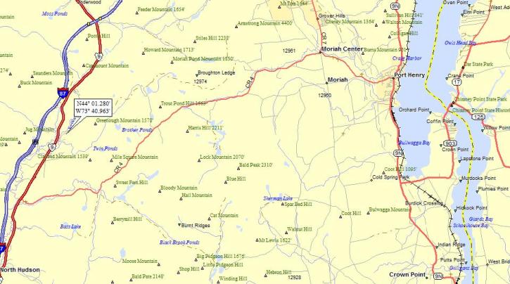
Dan – Here’s an eastern state with a longstanding OS tradition . . . NY; 35/29; 5/10; 13; 156.3. Here’s my landing map:

As you can see, I landed in a rather interesting location: just east of the NY State Thruway, in the Adirondacks. The lake off to the east is Lake Champlain (which forms the border with VT). The most significant town in the area is Port Henry. Here’s a broader view:

A new river, the Schroon. The Schroon flows south into Schroon Lake, thence to the Hudson (12th hit).
I’ll admit to being uninspired about Port Henry. It’s at a cool location, right on Lake Champlain, and the area is loaded with early American history, so I don’t know what my problem is. But then I stumbled on a discussion of the geology of the Champlain Valley, and I figured what-the-heck.
This is generally the sort of thing that gives geology a bad name, but I’ll give it a shot. I’ll start with some observations that were easily made by geologists a long time ago. To the west are the Adirondacks, very old mushed-up metamorphic rocks. To the east are the Green Mountains, also very old mushed-up metamorphic rocks. But in the Champlain Valley are younger (although still very old), but not-mushed-up sedimentary rocks like sandstone and limestone. In fact, there are some fossil coral limestone beds generally thought to represent the oldest corals on earth.
So, geologists wonder how all of this stuff came to be. That’s what we do. We have this peculiar sort of curiosity that really wants to know the “why” of just about anything on earth. Stuff like mountains and valleys and volcanoes can all be observed, but we really want to know “why” and “how.”
So anyway, what’s going on in the Champlain Valley? Well, as is our wont, we geologists start a long time ago. Here’s an east-west geologic cross section (a slice of the earth), looking north across the Champlain Valley. Oh yeah, I forgot. It’s from about 550 million years ago. I’m borrowing pictures and words from a University of Vermont website, “Shelburne Landscape Change.” (As usual, my words are in blue and theirs are in black.)

Layers of sediment deposited in an ancient sea would eventually become the sedimentary rocks seen today in the Champlain Valley. These rocks also preserved fossils of early marine life forms, including trilobites, corals, and brachiopods. The oldest known fossil reef in the world can still be seen in limestone beds outcropping in the Champlain Islands of northern Vermont.
Fast forward a hundred million years or so, and continental tectonic plates have collided. The collision scrunched everything. The sediment layers broke apart, so that huge pieces slid over one another. Remember that tectonic plates move very slowly, like at most a few inches per year. But hey, we have tens of million years to play around with. Anyway, this is what it looked like after the collision:

As the crustal plates collided, the compressed sedimentary rocks began to rise. Several major faults were formed, where entire blocks of rock thousands of feet thick were thrust up over one another. (Note how the sequences of sedimentary layers repeats, showing how they got pushed up over one another.) These faults can be traced today.
The mountains to the east (part of the tectonic plate that cruised upon the scene and broke up the sedimentary rocks) are what ended up being the Green Mountains (the Adirondacks have yet to make their appearance).
Fast forward another couple of hundred million years, and this is now the scene:

What will become the Champlain Valley is isolated within the continent, away from oceans. This was the condition for hundreds of millions of years. At some point (the timing is unsure), the land to the west began to uplift again, developing the steeper topography of today’s Adirondack Mountains. The exact nature of this uplift is unknown, but it is still continuing today.
Fast forwarding once again, all the way to the present (well, almost all of the way to the present). Now it’s about 25,000 years ago. This is the scene (and yes, the white is glacial ice):

As the glaciers moved over the Champlain Valley, they helped carve out the modern topography of the valley, including the present bed of Lake Champlain. The ice blunted the Green Mountains and Adirondacks and shaped the outcrops of sedimentary rocks seen today. At their peak, the glaciers would have completely covered everything in Vermont.
Move forward a blink of an eye, and it’s now 10,000 ago, just after the glaciers melted:

As the glaciers eventually retreated, they dammed the natural northward drainage of the Champlain Valley. The land had been so depressed by the weight of the ice that for a brief time, the Atlantic Ocean flooded the Champlain Valley through the St. Lawrence Seaway. But then, the land rebounded and restored a northward drainage. The extensive ancient lake (that was much larger than today’s Lake Champlain) left a thick blanket ofvclay across much of the Champlain Valley.
Another blink later, and it’s today:

Today, Lake Champlain divides the old metamorphic rocks of the Adirondacks from the faulted sedimentary rocks of the Champlain Valley, which eventually give way to the younger (compared to the Adirondacks) metamorphic rocks of the Green Mountains to the east.
Phew. Well, I enjoyed that. You? Anyway, back to just a little more-traditional ALAD fare. Here’s a 1908 picture of a steamer docked at Port Henry:

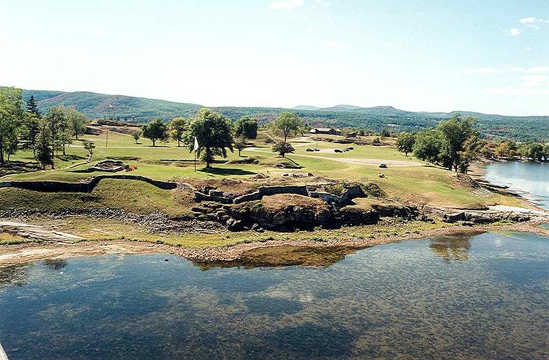
Here are the ruins of a Fort St. Frederic, which is near Coffin Point near the bridge over the lake (see landing map):

From Wiki, about the fort (this is actually pretty cool):
Fort St. Frédéric was a French fort built on Lake Champlain to secure the region against British colonization and to allow the French to control the use of Lake Champlain.
Construction started in 1734. When complete, the walls of the towering redoubt were twelve feet thick and four stories high, with cannons on each level. Fort St. Frédéric was manned by hundreds of officers and troops.
The fort gave the French control of the Lake Champlain Valley. It was the only permanent fort in the area until the building of Carillon at Ticonderoga starting in 1755. Many French raids originated from here and many British raids targeted this stronghold. It was constructed on the tip of a strategic peninsula, at a very narrow point. The cannons of Fort St. Frédéric and of the later British fort here, Crown Point, were capable of halting all north-south travel on the lake.
In 1759 when the British forces moved against Fort St. Frédéric during the French and Indian War, the French destroyed the Fort just before retreating northward. The British then built Fort Crown Point just southwest of the ruins of the French fort, starting in the fall of 1759. The remains of both forts are now a state historic site located in New York. Both are also U.S. National Historic Landmarks.
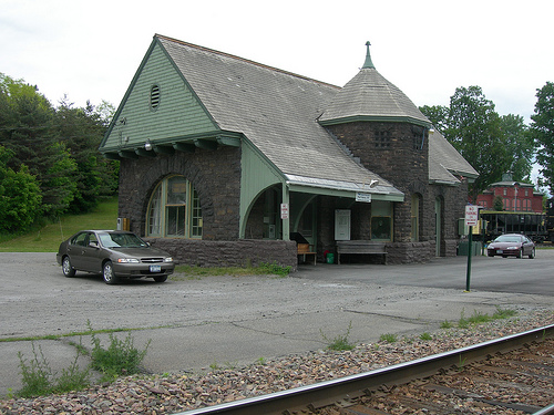
See, I told you there was a lot of history around here! And here’s the lovely train station in Port Henry:

KS
Greg
© 2009 A Landing A Day