Nänikon / Mettmenried
Nänikon / Mettmenried is a locality in Uster, Canton of Zurich and has about 382 residents. Nänikon / Mettmenried is situated close to the localities Greifensee / Langacher and Greifensee / Müllerwis / Seilerwis.Notable Places in the Area
Nänikon-Greifensee railway station
Railway stop

Photo: Beata May, CC BY-SA 3.0.
Nänikon-Greifensee is a railway station in the Swiss canton of Zürich.
Greifensee Castle
Castle

Photo: Roland zh, CC BY-SA 3.0.
Greifensee Castle is a castle in the municipality of Greifensee and the canton of Zurich in Switzerland.
Greifensee Reformed Church
Church

Photo: Roland zh, CC BY-SA 3.0.
Reformierte Kirche Greifensee, is a church and a listed heritage building in the municipality of Greifensee, Canton of Zürich, Switzerland.
Localities in the Area
Greifensee
Village
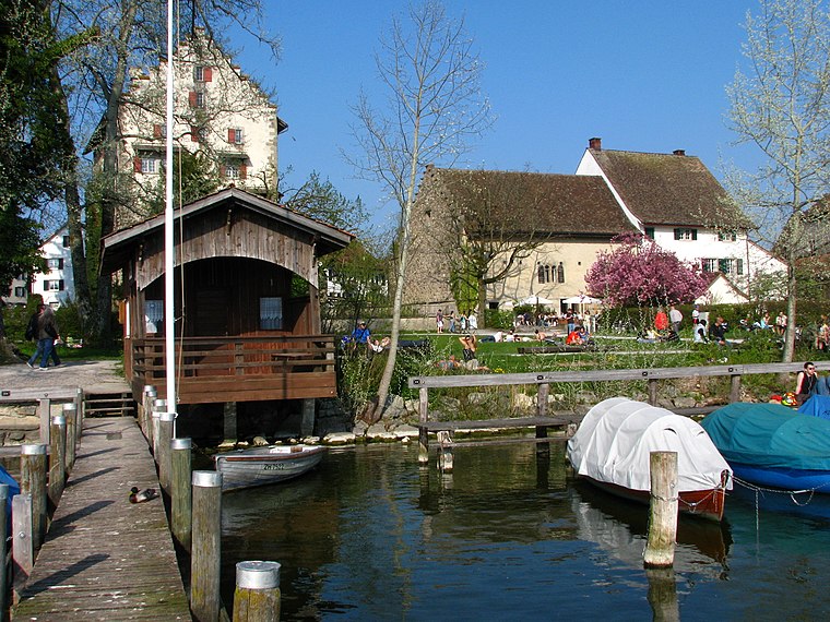
Photo: Roland zh, CC BY-SA 3.0.
Uster is a city near Zurich, Switzerland. Uster lies 350m above sea level, so it is just in the winter snow.
Volketswil
Town

Photo: DidiWeidmann, CC BY-SA 3.0.
Volketswil is a municipality in the district of Uster in the canton of Zürich in Switzerland.
Schwerzenbach
Village

Photo: Roland zh, CC BY-SA 3.0.
Schwerzenbach is a municipality in the district of Uster in the canton of Zürich in Switzerland, and belongs to the Glatt Valley. Schwerzenbach is situated 3 km northwest of Nänikon / Mettmenried.
Nänikon / Mettmenried
- Type: Locality with 382 residents
- Location: Uster, Uster District, Canton of Zurich, Zurich, Switzerland, Central Europe, Europe
- View on OpenStreetMap
Latitude
47.36851° or 47° 22' 7" northLongitude
8.68533° or 8° 41' 7" eastPopulation
382Elevation
446 metres (1,463 feet)Open Location Code
8FVC9M9P+C4GeoNames ID
6294592Nänikon / Mettmenried Satellite Map
© OpenStreetMap, Mapbox and Maxar
Also Known As
- Mettmenried
- Naenikon / Mettmenried
Localities in the Area
- Greifensee / LangacherLocality
- GreifenseeLocality
- Greifensee / Müllerwis / SeilerwisLocality
- Greifensee / MettmenLocality
- Greifensee / Ladenzentrum StationsstrasseLocality
Landmarks in the Area
- Golf Campus MilandiaGolf course
- AabachStream
- GreifenseeLake
- Schwerzenbach ZHRailway stop, 2½ km northwest
- Klinik Pyramide SchwerzenbachHospital, 3 km northwest
Escape to a Random Place
Discover other destinations in the world.
About Mapcarta. Thanks to Mapbox for providing amazing maps. Text is available under the CC BY-SA 4.0 license, excluding photos, directions and the map. Photo: Roland zh, CC BY-SA 3.0.