Haute Ecole De Bruxelles / Esi
Haute Ecole De Bruxelles / Esi is a college in Brussels, Belgium. Haute Ecole De Bruxelles / Esi is situated close to the neighborhood Freedom Quarter and the museum Comic centrum.Notable Places in the Area
Cathedral of St. Michael and St. Gudula
Church

Photo: Donaldytong, CC BY-SA 3.0.
The Cathedral of St. Michael and St. Gudula, usually shortened to the Cathedral of St. Cathedral of St. Michael and St. Gudula is situated 330 metres southwest of Haute Ecole De Bruxelles / Esi.
Grand Place
Square
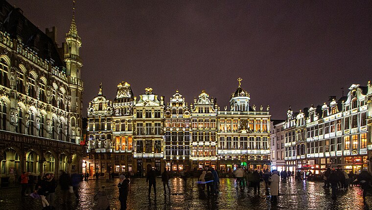
Photo: VitVit, CC BY-SA 4.0.
The Grand-Place or Grote Markt is the central square of Brussels, Belgium. Grand Place is situated 1 km west of Haute Ecole De Bruxelles / Esi.
Comic centrum
Museum
Photo: Ramón, CC BY-SA 2.0.
The Belgian Comic Strip Center is a museum in central Brussels, Belgium, dedicated to Belgian comics. Comic centrum is situated 330 metres northwest of Haute Ecole De Bruxelles / Esi.
Localities in the Area

Saint-Josse-ten-Noode
Town
Photo: charles lecompte, CC BY-SA 3.0.
Saint-Josse-ten-Noode or Sint-Joost-ten-Node, often simply called Saint-Josse in French or Sint-Joost in Dutch, is one of the 19 municipalities of the Brussels-Capital Region, Belgium.
Pentagon

Photo: Hullie, CC BY-SA 3.0.
The Pentagon is the historical center of Brussels. It derives its name from the pentagonal shape of the inner beltway that surrounds the area.
Haute Ecole De Bruxelles / Esi
- Type: College
- Category: education
- Location: Brussels, Arrondissement of Brussels-Capital, Brussels, Brussels Capital, Belgium, Benelux, Europe
- View on OpenStreetMap
Latitude
50.84956° or 50° 50' 58" northLongitude
4.36394° or 4° 21' 50" eastElevation
61 metres (200 feet)Open Location Code
9F26R9X7+RHGeoNames ID
6695921Haute Ecole De Bruxelles / Esi Satellite Map
© OpenStreetMap, Mapbox and Maxar
Localities in the Area
- European districtLocality
- Centre
- Sablon areaNeighborhood
- European Quarter
- Dansaert areaNeighborhood
Places in the Area
- Haute Ecole De La Communauté Française Paul Henri Spaak / AlgemeenCollege
- Le Bier CircusBrewery, 130 metres southeast
- Royal CentreHotel, 130 metres north
- Best Western Hotel Royal CenterHotel, 160 metres north
- Best Western Royal CentreHotel, 160 metres north
Popular Destinations in Brussels
Discover Pentagon, Centre, Schaarbeek and Heysel.
Escape to a Random Place
Discover other colleges in the world.
About Mapcarta. Thanks to Mapbox for providing amazing maps. Text is available under the CC BY-SA 4.0 license, excluding photos, directions and the map. Photo: Hullie, CC BY-SA 3.0.