Spotlight: Rizal Province, General Information

Spotlight: Rizal Province, General Information
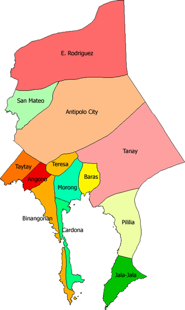
Location
Rizal is one of the Philippines first class provinces that belongs to CALABARZON (CA-vite, LA-guna, BA-tangas, R-izal, Que-ZON) Region or region IV-A in the island of Luzon. The province enjoys a natural beauty of nature and a perfect setting for investments, business establishments and settlements. It is bounded by Sierra Madre Mountain Ranges and Quezon Province in the east, the province Laguna in the soutwest, the province of Bulacan in the north, Metropolitan Manila in the west-northwest portion and by Laguna de Bay in south/south-western portion. Rizal is one of the neighboring provinces of Metro Manila. It takes an hour drive from major commercial districts and centers of Metropolis to reach the province's best places. Rizal is a green province which is the best place to unwind from crowded and polluted metropolis.
Click the thumbnail to view the image
According to the blogs posted from Paraiso Philippines Mabuhay, qouted as follows; *'According to urban planners, it is the country’s next business capital due to its strategic geographical location; and based on the latest national survey, few people of this province are experiencing poverty compared to other places nationwide'.*yet Rizal province has lots of places to develop into a productive and conducive place for investments and urban development. The only things necessary are appropriate planning and land development. See Investments.
Symbols and Meanings
The Sun Wreath of Laurel Leaves and Dove symbolize the peace and tranquility obtaining in the Province.
The official colors are gold, green, and blue.
The Crown signifies the devotion of the Rizaleños to the Virgin Mary, patroness of travelers, better known as Our lady of Peace and Good Voyage, whose image is enshrined in the Antipolo Cathedral which is visited by devotees from all over the land.
The Cross stands for the belief in Christianity by most of the people in the Province who draw spiritual sustenance from their faith.
The Ladle with Molten and Rice Paddies depict both industrial and agricultural development.
The Water represents Laguna de Bay (Lake of Bay) which is a source of livelihood fishing, irrigation, transportation, power, etc.
The Rope around the Seal signifies unity and cooperation among the people.
The Satellite Disc, Power Transmission Lines and Mechanical Gear signify global link through communication and industrial progress.
The Province was named after the National Hero Dr. Jose P. Rizal. Hence, his picture is the centerpiece of the Seal.
1901 is the year the province was established on the eleventh day of June.
Climate
Rizal Province is endowed with Type 1 climate, with two pronounced seasons, dry season from November to April and wet season for the rest of the year. This type of climate is highly favorable for agricultural and industrial development to be productive.
Topography
The province's topography is a combination of valleys and mountains; flat low-lying areas on the western portion which are mostly urbanized and populated, and the rugged ridges and rolling hills which form part of the Sierra Madre Mountain ranges in the eastern portion. Resting in the middle of Laguna de Bay, is the Philippines' largest lake island, the Talim Island which extends 13 miles across the lake.
Resources
Generally, Rizal Province is an agricultural province. The potential of agriculture remain largely untapped with large areas of land still stand undisturbed and waiting to be developed.
Fishing is a long thriving industry. The 90,000 hectares Laguna de Bay is the province’s primary source of freshwater fish species and other marine life. Eight municipalities with 83 barangays lie along the shoreline and depend on the lake for fishing and aquatic activities.
Substantial amount of non-metallic mineral deposits consisting of construction materials in the form of rock aggregates and volcanic tuff, sand and gravel, limestone, marble, guano/rock phosphate also exist in the province which can fuel other potential industries and economic activities.
The availability of red clay and the large deposits of raw materials in Antipolo City, Tanay and Baras in the form of limestone, dacite, diorite, siliceous sand and shale-sandstone used for the manufacturing of cement, a basic material used in construction can also be made into terra cotta, ceramic and brick makings.
People and Community
The province is inhabited mostly by Tagalogs. Minority of other ethnic groups are visayas, ilocanos, and other local groups. It has a population of 2,284.046 with a labor force consisting of 1,272,000 or 55.7% of the total population. Its people are its number one resource, known to be consummate artists and craftsmen. The literacy rate is 100%. The primary dialect is tagalog with english as the second language.
Rizal Socio-Economic Briefer
The Province of Rizal is located directly east of Metro Manila, bounded on the north by Bulacan Province, on the east by the provinces of Laguna and Quezon and on the south by Laguna de Bay. It is accessible from Manila via Ortigas Avenue and from Quezon City via Marcos Highway and Sumulong Highway. It is a part of Region IV-A or the Calabarzon Region.
Land Area *as of December 2013 - 118,265 Has.
Income Class - First
Congressional District - 2 for Province, 2 for Antipolo
Number of LGUs - 1 City, 13 Municipality
Number of Barangay- 189Protected Areas
Hinulugang Taktak Protected Landscape - Antipolo City - 3.20 Has.
Pamitinan Protected Landscape - Rodriguez (Cave System and Wawa Dam) - 608 Has.
Kaliwa Watershed - 27,608 Has.
Upper Marikina River Basin Protected Landscape - 26,125 Has.
Source: Rizal PDPFP 2014-2020Demography
Total Population (1 August 2015) - 2,884,227
Male - 1,444,063
Female - 1,440,164
Growth Rate (2010-2015) - 2.88%
Population Density - *2,453 persons/sq. km
Source: PSA, *PPDOEducation
Functional Literacy Rate (2019) - 99.70%
Enrolment 2017
Elementary 450,795
Secondary - 230,519
Number of Elementary Schools (2016-2017)
Public - 257
Private - 624
Number of Highschool(2016-2017)
Public - 112
Private - 115
Source: DepEd-Rizal/AntipoloBusiness and Commerce
Total Business Establishment
2015 - 41,345
as of August 8, 2016 - 37,154
Number of Banks
Rural - 46
Universal/Commercial - 153
Savings - 10
Source: C/MBPLOs, C/MPDOsRoad Network
National Roads - 231.251 Kms.
Concrete Pavement - 28.08 Kms.
Asphalt Overlay - 208.171 Kms.
Length of Bridges - 1.517 Kms.
Source: DPWH Rizal Engr. Office Dist. 1 and 2Resources and Utilities
Powerplants - National Grid Corporation
Power Utility - Meralco
Water Utility - Manila Water, INC. Local Utilities, Cooperatives
Communication Utilities/ Internet Provider - PLDT, Smart, Globe, Sun, Talk and Text and TM
Source: C/MBPLOsHealth and Services 2016
Hospital
Government - 11
Private - 24
Source: PHOhttp://www.rizalprovince.ph/pages/generalinformation.html
 0 Likes13 Replies

a good info thank you

Thank you. ❤️

Thank you

Thanks

Thank you. Anlaki po pala ng Antipolo haha
Thanks
Thanks
Thanks
Thanks
Thanks

THANKS!

Thanks
Thanks


