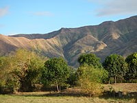
Zambales Province is located in the Central Luzon region, north of Bataan and lies on the western shores of Luzon along the West Philippine Sea. Zambales Province is noted for its picturesque coastline featuring many coves and inlets and offers an authentic slice of coastal life. Its thin coastline has generated a string of small fishing villages, supported by fishing, making bagoong (fermented fish sauce) and harvesting salt, and by their cottage industries. The rugged Zambales Mountains occupying the eastern portion of the long, narrow province provide a natural barrier for the province. The range stretches from Lingayen Gulf in the north to the entrance of Manila Bay in the south and rises to High Peak, about 6,683 ft in the north central Zambales province. Zambales is the second largest among the seven provinces of Central Luzon after Nueva Ecija.
Subic Bay, at the southern end of the province, provides a natural harbor and was the location of the U.S. Naval Base Subic Bay until its closure in 1992. The chartered city of Olongapo is in the south on Subic Bay.
Zambales came from the word Zambal which is a Hispanized term for Sambali, referring to the native language spoken by the early Austronesian inhabitants of the place. Another version states that the name came from the word samba, meaning worship because when the Spanish came, they found the natives to be highly superstitious, worshipping the spirits of their ancestors and believing in mysteries that have been handed down through generations. It could also originate from the word Zambo, a term used by the Iberian (Spanish and Portuguese) empires to distinguish people of African descent. The province is home to the Aetas, the aboriginal people of the Philippines who share Afro-ethnic similarities.
The Aeta people of Mount Pinatubo were the earliest inhabitants. They were later followed by the Sambal people, an Austronesian people, said to be of Malay descent, but differed from neighboring groups in that the men shaved their heads, leaving only a large lock of hair at the back. Most of the indigenous tribes – the Zambals and the Aetas – moved into Luzon’s interior with the arrival of the more dominant Tagalog and Ilocano settlers.
Today, Tagalogs have resettled southern Zambales, with Ilocanos in the central region. The indigenous Zambals have been pushed north, near Pangasinan, where in the mountain areas there were once government reservations for Aeta Negritos. Owing to the destruction of Mt. Pinatubo, however many of the Aetas have been forced to relocate elsewhere.
Most of the people of southern Zambales are migrants from different parts of the country due to the influx of job opportunities brought on by the U.S. Subic Naval Base (San Antonio and Subic) during the American regime of the country. Many people found jobs and permanently settled there. The presence of the Americans greatly influenced the culture and way of life of the inhabitants.
Together with Bataan, Zambales was among the first areas of Luzon brought under Spanish control. Among the earliest towns founded were Subic in 1572; Botolan also in 1572; Masinloc in 1607; Iba in 1611; and Santa Cruz in 1612. When Juan de Salcedo plundered the region’s western coast in 1572, he encountered a fierce and proud mountain people, the Zambals, who gave him such trouble that he mounted a punitive expedition to eradicate them.
During the Spanish period, a 1774 map was made, which clearly named Scarborough Shoals as Panacot Shoal, a feature under complete sovereignty of Spanish Philippines, specifically of Zambales. The shoal’s name was chosen by Captain Philip D’Auvergne, whose East India Company, East Indiaman Scarborough briefly grounded on one of the rocks on September 12, 1784, before sailing on to China. When the Philippines was granted independence in the 19th century and 20th century, Scarborough Shoal was passed by the colonial governments to the sovereign Republic of the Philippines.
Masinloc was the province’s first capital. However, the capital was moved around to three different towns during its history before finally settling in Iba, due to its strategic location in the middle of the province. The first civil governor of Zambales during the colonial American era was Potenciano Lesaca from 1901-1903.
During the dictatorship of Ferdinand Marcos, Zambales was one of the most militarized areas in the Philippines as majority of the people were against martial rule. Many opposition Sambals were detained, tortured, killed, electrocuted at the genitalia, or were listed as ‘missing’. The province was one of the main supporters of the People Power Revolution in Manila, which toppled the 21-year dictatorship and installed Corazon Aquino as president, bringing back democracy to the country.
The 2012 Scarborough Shoal standoff led to a situation where access to the shoal was restricted by the People’s Republic of China. However, in 2016, following meetings between the Philippine president Duterte and his PRC counterparts, the PRC allowed Filipino fishermen to access the shoals for fishing.
In 2018, it was revealed that for every 3,000 peso worth of fish catch by Sambal fisherfolks, China siphoned them in exchange for ‘two bottles of mineral water’ worth 20 pesos. The revelations led to public unrest against China and the Duterte-administered Philippine government. Filipino president Rodrigo Duterte fired back against his fellow Filipinos, including those from Zambales, saying that China’s acts were ‘fine’ as they were ‘only barter’. In June 14, 2018, China’s destruction of Scarborough Shoal’s reefs surged to an extent which they became visible via Google Earth and Philippine satellites, as confirmed by the University of the Philippine Diliman.
Sources:
Encyclopedia Britannica
Insight Guide Philippines by Discovery Channel
Philippines Handbook by Carl Parkes
Travelers Philippines Companion by Kirsten Ellis
Wikipedia

Reblogged this on Rosalinda R Morgan.
LikeLike
Amazing how the re-settling seems to happen. As always, excellent history, Rose.
LikeLiked by 1 person
Thanks GP. I find Zambales has a fascinating history!
LikeLiked by 1 person