Quirino is subdivided into 6 municipalities.
* Aglipay
* Cabarroguis
* Diffun
* Maddela
* Nagtipunan
* Saguday
Aglipay, officially the Municipality of Aglipay, is a 3rd class municipality in the province of Quirino, Philippines. According to the 2015 census, it has a population of 27,787 people.
Aglipay is politically subdivided into 25 barangays.
- Dagupan
- Dumabel
- Dungo (Osmeña)
- Guinalbin
- Ligaya
- Palacian
- Pinaripad Sur
- Progreso (Poblacion)
- Ramos
- Rang-ayan
- San Antonio
- San Francisco
- San Leonardo
- San Ramon
- Victoria
- Villa Pagaduan
- Villa Santiago
- Alicia
- Cabugao
- Diodol
- Nagabgaban
- Pinaripad Norte
- San Benigno
- San Manuel
- Villa Ventura
Tourist spot in aglipay
Aglipay Caves – A series of 38 caves, seven of which have been developed as tourist spots. Located in the midst of rolling hills and verdant forests, …
Cabarroguis, officially the Municipality of Cabarroguis, is a 3rd class municipality and capital of the province of Quirino, Philippines. According to the 2015 census, it has a population of 30,582 people.
Cabarroguis is politically subdivided into 17 barangays.
TOURIST SPOT IN CABARROGUIS
JOSE ANCHETA FALLS

Diffun, officially the Municipality of Diffun, is a 2nd class municipality in the province of Quirino, Philippines. According to the 2015 census, it has a population of 52,569 people.

Diffun is politically subdivided into 33 barangays.
- Andres Bonifacio (Poblacion)
- Aurora East (Poblacion)
- Aurora West (Poblacion)
- Baguio Village
- Balagbag
- Bannawag
- Cajel
- Campamento
- Diego Silang
- Sittio Der-an
- Don Mariano Perez, Sr.
- Doña Imelda
- Dumanisi
- Gabriela Silang
- Gulac
- Guribang
- Ifugao Village
- Isidro Paredes
- Rizal (Poblacion)
- Liwayway
- Luttuad
- Magsaysay
- Makate
- Maria Clara
- Rafael Palma (Don Sergio Osm)
- Ricarte Norte
- Ricarte Sur
- San Antonio
- San Isidro
- San Pascual
- Villa Pascua
- Aklan Village
- Gregorio Pimentel
- Don Faustino Pagaduan
TOURISTSPOT IN DIFFUN
Nagbukel Municipal Tree Park and Nature Resort
Located at Barangay Luttuad, Diffun, and Quirino with an area of 16 hectares. Its special natural features are its glamorous caves, rocky limestone mountains with forest vegetation of small trees and forest trees plantation lying beside the grandeur Ganano river a tributary to Cagayan River. Nagbukel can be the best described of its breathtaking landscape of a helmet look-like and towns. Presently there are road trails and rock walls terraces. A five (5) minute travel from the town proper.

PUSUAC SPRING PARK
ocated at barangay Rizal, Diffun, Quirino with an area of almost one (1) hectare with its mystic bubbling hot water and surrounded by secondary growth forest and surrounded by an ashen rock formation. A fifteen minute ride from the town proper via an all weather type of road. Local tourists love to visit the place for its alluring and unique spring water and held their picnic, fishing and swimming thereat.

BATTUMBAKET FALLS
Located at barangay Don Mariano Perez, Diffun, Quirino with an area of thirty (30) hectares. Its special natural features are it’s almost 200 feet high clean and crystalline waterfalls down to its bluish lagoon and goes as tributary to the Ganano river, presence of virgin forest surrounding the area. Almost a one a hour walk on a trail from the Quirino provincial road passing through a blossoming flowers of wild orchids and forty five minutes for travel by a motorized vehicle from the town . The area is known for its natural monuments and wildlife habitat.

SUSONG DALAGA
Located at barangay Rizal, Diffun, Quirino with an area of ten (10) hectares and known for its panoramic breast shape like mountain and could view its surrounding fields and the Ganano river and local tourists love to visit the area during Lenten season for picnicking and sightseeing. A ten minute ride from the town proper since half of the roadway is being cemented.
There were a lot of improvements and amenities that can be seen around the place like cogon cottages, steps and its agro forestry as it were manage by an Ina-ina, a religious sector who reside near the area. There were a lot of facilities that can still be introduced like construction of rest rooms, cemented steps and more cottages and hall.

Maddela, officially the Municipality of Maddela, is a 1st class municipality in the province of Quirino, Philippines. According to the 2015 census, it has a population of 38,499 people.[3]
Maddela is the commercial hub of the province. It is located between the provinces of Isabela and Aurora.
Just recently, Maddela has been known as having some of the tourist attraction that made it famous.
The most famous Governors Rapid now can be found only here in Maddela particularly in the Barangay of Divisoria Sur. It started to be known most and it attracted too many tourist when Rated K of ABS-CBN featured it along with the Siitan of Nagtipunan, one of the Municipality of Quirino Province. At the moment, Maddela gladly smiles at improvement it receive.
Maddela is also known for its festival which is the “Panagsasalog”. It is an Ilocano term depicting the farmers when they were on their way to farm. The Panagsasalog Festival is yearly celebrated on the month of July 10–12. The festival is also celebrated with the yearly Search for Mutya ng Maddela along with some of the contested activities featured on that days. And on the last day, there would be a parade of the reigning beauties, municipal officials, barangay officials and with the drum and lyre corps of the near elementary and high schools.

Maddela is politically subdivided into 32 barangays.
- Abbag
- Balligui
- Buenavista
- Cabaruan
- Cabua-an
- Cofcaville
- Diduyon
- Dipintin
- Divisoria Norte
- Divisoria Sur (Bisangal)
- Dumabato Norte
- Dumabato Sur
- Lusod
- Manglad
- Pedlisan
- Poblacion Norte
- Poblacion Sur
- San Bernabe
- San Dionisio I
- San Martin
- San Pedro
- San Salvador
- Santo Niño
- Santo Tomas
- Villa Gracia
- Villa Hermosa Sur
- Villa Hermosa Norte
- Ysmael
- Villa Agullana
- Villa Jose V Ylanan
- Jose Ancheta
- Santa Maria
TOURIST SPOT IN MADDELA
Governor’s Rapids in Maddela, Quirino
Located in the town of Maddela is Governor’s Rapids which form part of a tributary of the Cagayan River. It features crystal clear waters which earned it the award of being among the cleanest inland bodies of water in the whole Cagayan Valley.
Maddela Falls
Maddela Water Falls is located in Brgy. Dumabato Sur a seven-staged waterfall with crystal clear water and pool basins where you can have a dip. The area is ideal for people looking for a place for picnics and relaxation. The surroundings are cool and shady because of the vibrant forest, which you can also explore. It is a good nature retreat and you can trek along the forest path while admiring

Nagtipunan, officially the Municipality of Nagtipunan, is a 1st class municipality in the province of Quirino, Philippines. According to the 2015 census, it has a population of 23,484 people.[3]
As the largest municipality in the province, it occupies a land area of 1,607.40 square kilometers, nearly half of the province itself.
The municipality is known for its natural environment, and is dubbed as the tourism capital of the province of Quirino

Nagtipunan is politically subdivided into 16 barangays.
- Anak
- Dipantan
- Dissimungal
- Guino (Giayan)
- Keat
- La Conwap (Guingin)
- Landingan
- Mataddi
- Matmad
- Ponggo (Urban)
- San Dionisio II
- San Pugo
- San Ramos
- Sangbay
- Wasid
- Asaklat
TOURIST SPOT IN NAGTIPUNAN
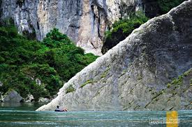
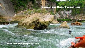
Bimmapor Rock Formation is located in Nagtipunan. Make Bimmapor Rock Formation part of your personalized Nagtipunan itinerary using our Nagtipunan road trip planning site
Mactol Falls is one of the three falls in the town of Nagtipunan, Province of Quirino. The other two is the Taigido and Sinabangan Falls. Many of the locals (except the tribe of Ilongot) knows and heard about the three falls but remain unknown sight for the Quirinians because of the location of the place.
The falls is about 50 meters (160 ft.) in height, it fill a basin of cold crystal clear water for about 22 meters (72 ft.) deep


History
Long before its formal creation as an independent province, Quirino was the forest region of the province of Nueva Vizcaya, inhabited by tribal groups known as the Negritos. They roamed the hinterlands and built their huts at the heart of the jungle.

An old map showing the current territories of Quirino as part of Nueva Vizcaya
On June 18, 1966, Republic Act 4734 was enacted, constituting the municipalities of Diffun, Saguday, Aglipay, and Maddela (all of Nueva Vizcaya province) into a new sub-province to be known as “Quirino”, named after the late Philippine president Elpidio Quirino.[3][4]
On June 21, 1969, Republic Act 5554 was enacted, amending RA 4734 and creating the municipality of Cabarroguis (now the provincial capital town), which was taken from portions of Diffun, Saguday, and Aglipay.[4][5]
Republic Act 6394, authored by then Congressman Leonardo B. Perez, was passed on September 10, 1971 further amending RA 5554 and separating the sub-province of Quirino from its mother province, Nueva Vizcaya, constituting it into a regular province.[4][6]
The province of Quirino was formally established on February 10, 1972 upon the assumption to office of the first elected provincial and municipal officials headed by Dionisio A. Sarandi as Provincial Governor.
On February 25, 1983, Batas Pambansa Blg. 345 was enacted, creating within Quirino the municipality of Nagtipunan, a division of the municipality of Maddela.[7]
Geography

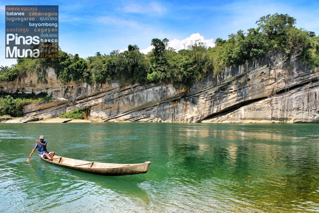
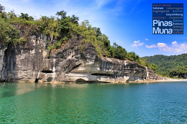
A section of the Cagayan River(lower river in the picture) beside the town of Maddela
Quirino covers a total area of 2,323.47 square kilometres (897.10 sq mi)[8] occupying the southeastern section of the Cagayan Valley region. A landlocked province, it is situated within the upper portion of the Cagayan River basin and bounded by Isabela on the north, Aurora on the east and southeast, and Nueva Vizcaya on the west and southwest.
The Sierra Madre mountain range provides a natural barrier on the eastern and southern border of the province and the Mamparang Range on the western part. The province is generally mountainous, with about 80 percent of the total land area covered by mountains and highlands. A large portion of the province lies within the Quirino Protected Landscape.
Panagdadapun Festiva
The province of Quirino rarely rings a bell in everyday conversation, but one week every September puts this province squarely in the eyes of the country: the Panagdadapun Festival.A GATHERING OF ALL QUIRINIANS. Street Dancing during the 40th Panagdadapun Festival in 2011. Image taken by Clifford Badongen, grabbed from Maddela, Quirino Facebook PagePanagdadapun is an Ilocano word which means assembly. It’s a word that’s so appropriate for the festival that it reverberates throughout the province of Quirino. Quririnians from all over the province gather to showcase what the province is all about in the week-long festiv
Food
Adobong Pato for Lunch in Cabarroguis, Quirino
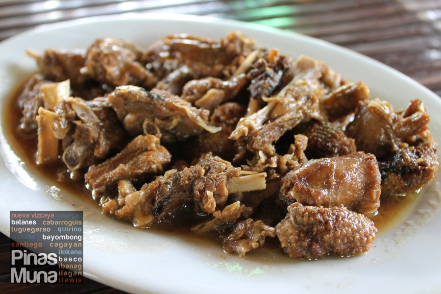
Adobo is a popular Filipino dish, typically cooked with pork or chicken marinated and simmered in vinegar, soy sauce, ginger and black peppers. Adobo may also be cocked with vegetables, tofu or hard boiled eggs.
A restaurant in the town of Cabarroguis, Quirino Province is known for its specialty adobo dish. Palm Restaurant takes pride in its adobong pato, an adobo dish cooked with white duck meat. Unlike most duck dishes which duck meat is usually tough, the duck meat in Palm Restuarant’s adobong pato is rather tender.
CULTURE IN THE PROVINCE
PEOPLE, CULTURE AND ARTS
The Ilongots and the Dumagats are the original inhabitants of the province, which used to be the forest region of Nueva Vizcaya. These tribal groups roamed the hinterlands, building their huts in the heart of the jungle. The Ilongots used to be a feared tribe because of their headhunting ritual, which coincides with the blooming of the red-blood flower of the “bagbag-tree”. They are simply half naked and clothed g-strings for the male and wrap skirts for the females. They are also fond of coiled wire bracelets and fancy jewelries.
The Ilongots are hunters and slash and burn farmers living around the headwaters of the Cagayan River who have a strong pride in their penchant for hunting heads but they have already abandoned the practice. Men do most of the hunting while the women plant rootcrops, rice, tobacco and bananas in small cleared fields. The Ilongots have little contact with lowland people except when occasionally trading dried deer meat.
Other cultural communities like the Ifugaos and the Igorots in search for the proverbial “greener pasture” migrated to the province and are now living in the highlands. Of the ethnic groups, the Ifugao have the greatest number.
With the onset of the Christian settlers like the Ilocanos, who form the majority of the people living in the province, the Tagalogs, Pangasinenses, and the other people from neighboring provinces, these indigenous tribes went deeper into the forest.
