Nawabganj District Town
Bangladesh /
Nawabganj /
World
/ Bangladesh
/ Nawabganj
/ Nawabganj
World / Bangladesh / Rajshahi / Rajshahi / Nawabganj
third-level administrative division, town district
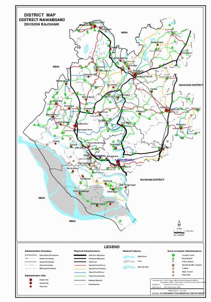
Nawabganj also known as 'Chapai Nawabganj' is a district (Rajshahi Division) in Northern Bangladesh with an area of 1744.33 sq km, is bounded by West Bengal of India on the north, south and west, Rajshahi and Naogaon districts on the east. The district lies under barind tract and consists of diaras and charlands (sandbars develop in riverbed). Main rives are Ganges, Mahananda, Pagla, Moraganga and Punarbhaba. Beel Bhatia, Beel Choral, Beel Hogla, Beel Singra, Sukrabari Damos, Maricha Dara, Beel Putimari, Beel Anal, Kumiradaha are the noted depressions. Annual average temperature: maximum 37.8°C, minimum 11.2°C; annual rainfall 1862 mm.
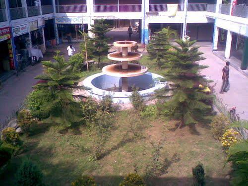
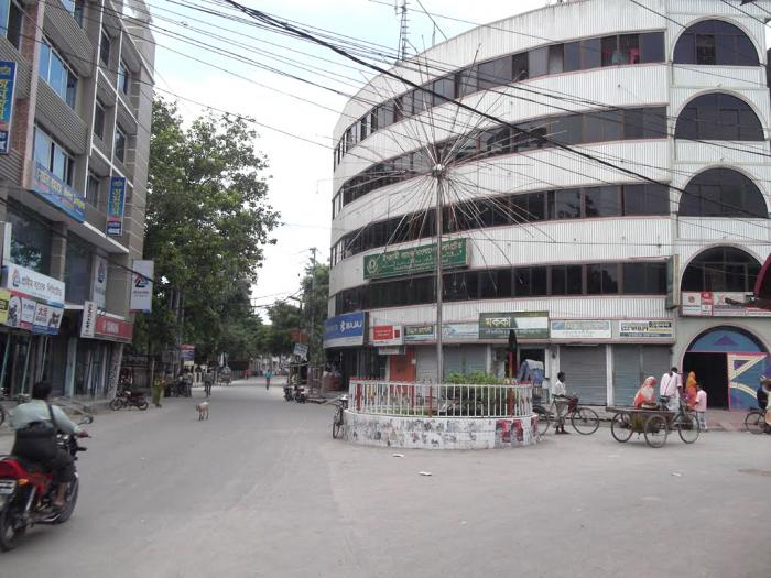
Nawabganj (Town) consists of 15 wards and 70 mahallas. The town centre is located at 24.5964855N 88.2775577E. The town has an area of 46.26 sq km. Nawabganj municipality was established in 1903. The town has a population of 153252; male 48.37% and female 51.63%; population density is 3313 per sq km. Literacy rate among the town people is 41.2%. The town has two dakbungalows, one circuit house, one officers' club, one BDR Camp, one Mango Research Centre and one horticulture centre.
Until 1947, Nawabganj was a thana under the district of Maldah (India). At the time of partition, it was upgraded to a Subdivision under Rajshahi district and again upgraded to a district in 1984. The district consists of 3 municipalities, 33 wards, 134 mahallas, 5 upazilas, 45 union parishads, 830 mouzas and 1136 villages. The upazilas are bholahat, gomastapur, nachole, nawabganj sadar, shibganj; municipalities are Nawabganj Sadar, Shibganj, Rohanpur.
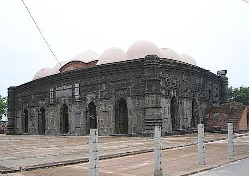
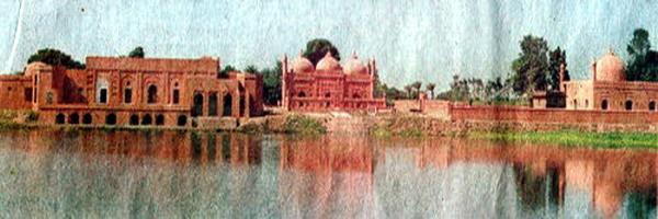
Archaeological heritage and relics: Chota Sona Mosque (1493-1519), Darashbari Mosque (1479), Rajbari (palace), Baragharia Kacharibari (revenue office), Chapai Mosque, Naoda Stupa (Buddhist monument), Jora Math (twin monastery), Nachole Palace, etc.
Historical events: Indigo Resistance Movement in 1830-35.
As of the 1991 Bangladesh census, population 1419534; male 50.12%, female 49.88%; Muslim 94.27%, Hindu 4.68%, Christian 0.23% and 0.82%.
Religious institutions: Mosque 1,135, temple 50 and church 5.
Literacy and educational institutions: Average literacy 23.8%; male 28.5%, female 19.1%. Educational institutions: government college 3, private college 40, technical institute 2, madrasa 97, government secondary school 4, private secondary school 171, junior high school 36, government primary school 370, private primary school 282, primary education training institute 1, vocational training institute 1, and horticulture research and training centre 1. Noted educational institutions: Harimohan Government High School (1895), Bholahat Rameshwar Pilot High School (1911), Adina Fazlul Haque College (1938), Nawabganj Government College (1955), Nawabganj Alia Madrasa (Kamil) (1964), Rohanpur Yeasuf Ali College (1967), Nawabganj Government Mohila College (1966), Kansat High School (1917), Dadanchal HM High School (1919), Kansat Soleman Degree College (1968).
Cultural organisations: Club 179, public Library 5, theatre stage 4, theatre group 10, literary society 5, women's organisation 5, cinema hall 12, community centre 3, shilpakola academy 1 and auditorium 6.
Main occupations: Agriculture 34.07%, commerce 16.6%, service 4.01%, agricultural labourer 24.31%, wage labourer 5.39%, construction 2.57% and others 13.05%.
Land use: Total cultivable land 132354 hectares, fallow land 12899 hectares. Single crop 46%, double crop 45% and triple crop land 9%; cultivable land under irrigation 60%. Mango gardens occupy 6690 hectares.
Land control: Among the peasants 35% are landless, 44% marginal, 27% intermediate and 4% rich; cultivable land per head 0.07 hectare.
Main crops: Paddy, jute, sugarcane, wheat, betel leaf, oil seeds, pulses.
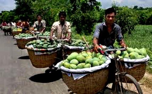
Main fruits: Mango, jackfruit, litchi, black berry, palm, coconut, watermelon and boroi.
Fisheries, dairies, poultries Fishery 2, dairy 142, poultry 39.
Communication facilities- Roads: pucca 286.12 km, semi pucca 2006.81 km; railways 51.20 km; waterways 69 nautical mile.
Manufactories: Silk mill, textile mill, cold storage and aluminium factory.
Cottage industries: About 6500 cottage industries including silk, weaving, copper, bell-metal and brass works; nakshi kantha; decorated shika (hanging rope-shelf); potteries; hand-fans; bamboo and cane-works, etc.
Main exports: Mango, jackfruit, betel leaf, sugarcane, date molasses, silk sari, copper, bell-metal & brass work.
NGO activities: Operationally important NGOs are CARE, brac, asa, proshika, IDE, DASCO, ccdb, nijera kari, thengamara mahila sabuj sangha (TMSS), Trinamul, Vision, Proyash, Manobic Unnayan Society, Swanirvar Artha-Samajik Unnayan Sangstha, Kolyani Mohila Sangsad, Amnura Santal Mission, BIKE, BISE, BIDOS, BARIO, etc.
Health centres: District sadar hospital 1, upazila health complex 5, health and family planning centre 45, chest disease and TB clinic 1, diabetic hospital (private) 1, heart foundation (private) 1, maternity care and child welfare centre 1.
Chapai Nawabganj is called the capital of mango. The main product which mainly accelerates the economy of this district. Lots of mangoes are produced in summer each year. Most of the land of this district is full of mango orchards where various kinds of mango are produced. The economy is surrounded by the production of the mango in this district. The main part of mango production is the Shibganj, Bholahat and Gamostapur upozilla.
'Gombhira' songis one kind of folk song popular in this district and as well as the northeaster part of Bangladesh. Gambhira reflects contemporary social problems through witty dialogue, songs, dances and jokes. This is the main part in any cultural celebration in this district with great entertainment and explanation of social problems.
Place of interest: Choto Sona Mosque
One of the most graceful monument of the Sultanate period is the Chhota Sona Masjid or Small Golden Mosque at Gaur in Chapainawabganj Built by one Wali Muhammad during the reign of Sultan Alauddin Husain Shah (1493–1519). Originally it was roofed over with 15 gold-gilded domes including the 3 Chauchala domes in the middle row, from which it derives its curious name.
Nawabganj (Town) consists of 15 wards and 70 mahallas. The town centre is located at 24.5964855N 88.2775577E. The town has an area of 46.26 sq km. Nawabganj municipality was established in 1903. The town has a population of 153252; male 48.37% and female 51.63%; population density is 3313 per sq km. Literacy rate among the town people is 41.2%. The town has two dakbungalows, one circuit house, one officers' club, one BDR Camp, one Mango Research Centre and one horticulture centre.
Until 1947, Nawabganj was a thana under the district of Maldah (India). At the time of partition, it was upgraded to a Subdivision under Rajshahi district and again upgraded to a district in 1984. The district consists of 3 municipalities, 33 wards, 134 mahallas, 5 upazilas, 45 union parishads, 830 mouzas and 1136 villages. The upazilas are bholahat, gomastapur, nachole, nawabganj sadar, shibganj; municipalities are Nawabganj Sadar, Shibganj, Rohanpur.
Archaeological heritage and relics: Chota Sona Mosque (1493-1519), Darashbari Mosque (1479), Rajbari (palace), Baragharia Kacharibari (revenue office), Chapai Mosque, Naoda Stupa (Buddhist monument), Jora Math (twin monastery), Nachole Palace, etc.
Historical events: Indigo Resistance Movement in 1830-35.
As of the 1991 Bangladesh census, population 1419534; male 50.12%, female 49.88%; Muslim 94.27%, Hindu 4.68%, Christian 0.23% and 0.82%.
Religious institutions: Mosque 1,135, temple 50 and church 5.
Literacy and educational institutions: Average literacy 23.8%; male 28.5%, female 19.1%. Educational institutions: government college 3, private college 40, technical institute 2, madrasa 97, government secondary school 4, private secondary school 171, junior high school 36, government primary school 370, private primary school 282, primary education training institute 1, vocational training institute 1, and horticulture research and training centre 1. Noted educational institutions: Harimohan Government High School (1895), Bholahat Rameshwar Pilot High School (1911), Adina Fazlul Haque College (1938), Nawabganj Government College (1955), Nawabganj Alia Madrasa (Kamil) (1964), Rohanpur Yeasuf Ali College (1967), Nawabganj Government Mohila College (1966), Kansat High School (1917), Dadanchal HM High School (1919), Kansat Soleman Degree College (1968).
Cultural organisations: Club 179, public Library 5, theatre stage 4, theatre group 10, literary society 5, women's organisation 5, cinema hall 12, community centre 3, shilpakola academy 1 and auditorium 6.
Main occupations: Agriculture 34.07%, commerce 16.6%, service 4.01%, agricultural labourer 24.31%, wage labourer 5.39%, construction 2.57% and others 13.05%.
Land use: Total cultivable land 132354 hectares, fallow land 12899 hectares. Single crop 46%, double crop 45% and triple crop land 9%; cultivable land under irrigation 60%. Mango gardens occupy 6690 hectares.
Land control: Among the peasants 35% are landless, 44% marginal, 27% intermediate and 4% rich; cultivable land per head 0.07 hectare.
Main crops: Paddy, jute, sugarcane, wheat, betel leaf, oil seeds, pulses.
Main fruits: Mango, jackfruit, litchi, black berry, palm, coconut, watermelon and boroi.
Fisheries, dairies, poultries Fishery 2, dairy 142, poultry 39.
Communication facilities- Roads: pucca 286.12 km, semi pucca 2006.81 km; railways 51.20 km; waterways 69 nautical mile.
Manufactories: Silk mill, textile mill, cold storage and aluminium factory.
Cottage industries: About 6500 cottage industries including silk, weaving, copper, bell-metal and brass works; nakshi kantha; decorated shika (hanging rope-shelf); potteries; hand-fans; bamboo and cane-works, etc.
Main exports: Mango, jackfruit, betel leaf, sugarcane, date molasses, silk sari, copper, bell-metal & brass work.
NGO activities: Operationally important NGOs are CARE, brac, asa, proshika, IDE, DASCO, ccdb, nijera kari, thengamara mahila sabuj sangha (TMSS), Trinamul, Vision, Proyash, Manobic Unnayan Society, Swanirvar Artha-Samajik Unnayan Sangstha, Kolyani Mohila Sangsad, Amnura Santal Mission, BIKE, BISE, BIDOS, BARIO, etc.
Health centres: District sadar hospital 1, upazila health complex 5, health and family planning centre 45, chest disease and TB clinic 1, diabetic hospital (private) 1, heart foundation (private) 1, maternity care and child welfare centre 1.
Chapai Nawabganj is called the capital of mango. The main product which mainly accelerates the economy of this district. Lots of mangoes are produced in summer each year. Most of the land of this district is full of mango orchards where various kinds of mango are produced. The economy is surrounded by the production of the mango in this district. The main part of mango production is the Shibganj, Bholahat and Gamostapur upozilla.
'Gombhira' songis one kind of folk song popular in this district and as well as the northeaster part of Bangladesh. Gambhira reflects contemporary social problems through witty dialogue, songs, dances and jokes. This is the main part in any cultural celebration in this district with great entertainment and explanation of social problems.
Place of interest: Choto Sona Mosque
One of the most graceful monument of the Sultanate period is the Chhota Sona Masjid or Small Golden Mosque at Gaur in Chapainawabganj Built by one Wali Muhammad during the reign of Sultan Alauddin Husain Shah (1493–1519). Originally it was roofed over with 15 gold-gilded domes including the 3 Chauchala domes in the middle row, from which it derives its curious name.
Nearby cities:
Coordinates: 24°35'9"N 88°15'47"E
- Meherpur District 74 km
- Chuadanga District 92 km
- Patran Tehsil 1364 km
- Tehsil Kallar Syedan 1764 km
- Bicholim Taluka 1797 km
- Pedne Taluka 1807 km
- Bardez Taluka 1811 km
- Garadagh District 4022 km
- Tegh Region 4253 km
- Meghri Municipality 4259 km
- Sadhur Mor Godagari Rajshahi 13 km
- Amnura 15 km
- MAHANANDA river 18 km
- Nachole Upazila HQ 23 km
- Rohanpur 27 km
- Gomastapur Upazila HQ 28 km
- Kopra (lake) 29 km
- Tanore Upazila HQ 31 km
- Niamatpur Upazila HQ 42 km
- Rajshahi Division 99 km
Comments