2015
TF4389 : Saltfleetby St. Peter, old church of St. Peter and moated site: aerial 2015
taken 8 years ago, near to Saltfleetby st Peter, Lincolnshire, England
The Geograph Britain and Ireland project aims to collect geographically representative photographs and information for every square kilometre of Great Britain and Ireland.
Read about the Geograph Project.
Read about the Geograph Project.
We have at least 2 images that match your query [https://www..org.uk//4777586] in the area! View them now
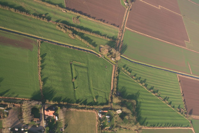
Saltfleetby St. Peter, old church of St. Peter and moated site: aerial 2015
Looking across (northwards) the B1200 and Mar Dyke. The church is in the trees at the bottom with the disused railway behind, and some fields of ridge and furrow, and old ditched enclosure. Possible Medieval settlement, in the form of enclosures and crofts. See: Link
See also aerial shot TF4389 : Saltfleetby St. Peter, old church of St. Peter and moated site: aerial 2015.
The ridge and furrow field on the right is shown from the ground in TF4390 : Experts in their own field?.
See also aerial shot TF4389 : Saltfleetby St. Peter, old church of St. Peter and moated site: aerial 2015.
The ridge and furrow field on the right is shown from the ground in TF4390 : Experts in their own field?.
 Map © Crown Copyright")
TIP: Click the map for more Large scale mapping
- Grid Square
- TF4389, 52 images (more nearby 🔍)
- Photographer
- Chris (more nearby)
- Date Taken
- Sunday, 27 December, 2015 (more nearby)
- Submitted
- Wednesday, 30 December, 2015
- Subject Location
-
OSGB36:
 TF 434 899 [100m precision]
WGS84: 53:23.1879N 0:9.3270E - Camera Location
-
OSGB36: TF 434 881
- View Direction
- NORTH (about 0 degrees)