2019
ST1910 : RAF Upottery (Smeatharpe): a tour of a WW2 airfield - Operations Block (1)
taken 5 years ago, near to Smeatharpe, Devon, England
RAF Upottery (Smeatharpe): a tour of a WW2 airfield - Operations Block (1)
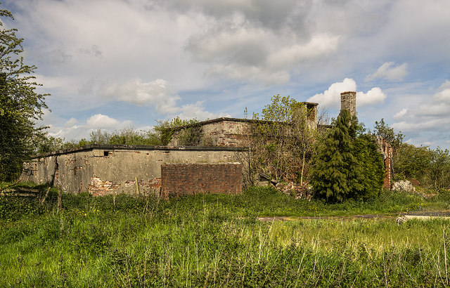
The Operations Block is the only surviving building on the administration site and therefore not on the airfield itself, it is nonetheless one of the most important buildings associated with it. All operational planning, communications critical to the airfield, and crew briefing and debriefing would have been conducted from here. Built of rendered permanent brick with a concrete roof, all entrances were protected by blast walls and entry was via air-locks.
A brief history: RAF Upottery near Smeatharpe was one of three airfields on the high plateau of the Blackdown Hills and the last of the three to have been built, opening on February 17th 1944. It was originally intended as a standard RAF class 'A' bomber base for use by the Americans under the 'Bolero' scheme of 1942. 'Bolero' was the code name given to the United States military troop build up in the United Kingdom during World War II that would eventually culminate in Operation Overlord, the largest cross-channel invasion operation in history.
RAF Upottery played its part by becoming one of several airfield sites in western England earmarked to accommodate a large force of Dakota aircraft and gliders for the forthcoming invasion. It was destined to be one of the airfields for the air assault element of the D-Day Landings: Operation Neptune - Mission Albany. It came under the control of the USAAF to become Station 462 under the 50th Wing, IX Troop Carrier Command, established to transport troops and supplies for the US Army in the European Theatre of Operations. The arrival of 439th Troop Carrier Group in April 1944 saw a seemingly endless stream of olive drab C47 Dakotas and gliders fly in from their former base at Balderton in Nottinghamshire, to continue their final training exercises for the major airborne assault on France.
Mission Albany was a parachute combat assault at night by the U.S. 101st Airborne Division that took place on June 6, 1944, part of the American airborne landings in Normandy during World War II. It was the opening step of Operation Neptune, the assault portion of the Allied invasion of Normandy, Operation Overlord. Four drop zones in France were chosen for the operation, Drop Zone C would be the area one mile west of Sainte Marie-du-Mont that the 439th Troop Carrier Group from RAF Upottery was tasked with, carrying troops of the 1st and 2nd Battalions 506th Parachute Infantry Regiment (PIR). The operation has since been made famous by the book and TV series 'Band of Brothers' which featured the 506th Parachute Infantry Regiment, 101st Airborne Division (Easy Company). Link
After their return to Upottery, the 439th then made arrangements to commence Operation Hackensack on the 7th June. Mission Hackensack was one of several follow up landing and supply operations flown during the invasion. It was the final glider assault of Operation Neptune into France, and RAF Upottery was one of several airfields from where the operation was conducted.
Following these major D-Day operations RAF Upottery entered a phase of comparatively low activity, and postwar it became a RAF sub-site of No. 265 Maintenance Unit. The RAF remained in occupation for another three years but it was only to use the vacant airfield as a war surplus storage area. Finally in November 1948 the RAF withdrew and the site was returned to agriculture, but was not declared surplus to requirements until 1957.
ST1910 : RAF Upottery (Smeatharpe): a tour of a WW2 airfield - Operations Block (2)
 Map © Crown Copyright")
TIP: Click the map for more Large scale mapping
- Grid Square
- ST1910, 16 images (more nearby 🔍)
- Photographer
- Mike Searle (more nearby)
- Date Taken
- Tuesday, 7 May, 2019 (more nearby)
- Submitted
- Thursday, 23 May, 2019
- Subject Location
-
OSGB36:
 ST 1953 1056 [10m precision]
WGS84: 50:53.3340N 3:8.7249W - Camera Location
-
OSGB36: ST 1956 1054
- View Direction
- West-northwest (about 292 degrees)