2020
TM0771 : Gislingham village sign
taken 4 years ago, near to Gislingham, Suffolk, England
The Geograph Britain and Ireland project aims to collect geographically representative photographs and information for every square kilometre of Great Britain and Ireland.
Read about the Geograph Project.
Read about the Geograph Project.
We have at least 1 images that match your query [https://www..org.uk//6649284] in the area! View them now
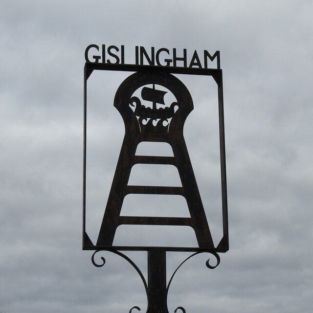
Gislingham village sign
Gislingham village sign is shaped like a keyhole but I believe it is a reference to the old windmill which stood without its sails in Mill Street behind Mill House.
At the top however, is a representation of a Viking longboat. A Viking by the name of Gisli or Gisyl settled at Gisleham near Lowestoft where he came ashore. His son with a similar name decided to set out west to seek his fortune and settled here and named it Gyselas ham, or Gyselas home, later abbreviated to Gislingham. Link
Village Signs of East Anglia
Village signs are typically placed along the principal road or in a prominent location such as a village green or close by the church. The design often depicts a particularly feature of the village or a scene from its history, heritage, or culture. They are typically made of wood or metal or a combination of both, the designs are often made by the local community.
Although they do appear in villages and towns all over the country they are more prominent in East Anglia than elsewhere in the country.
 Map © Crown Copyright")
TIP: Click the map for more Large scale mapping
- Grid Square
- TM0771, 75 images (more nearby 🔍)
- Photographer
- Adrian S Pye (more nearby)
- Date Taken
- Friday, 16 October, 2020 (more nearby)
- Submitted
- Friday, 23 October, 2020
- Subject Location
-
OSGB36:
 TM 07501 71757 [1m precision]
WGS84: 52:18.2827N 1:2.5274E - Camera Location
-
OSGB36: TM 0750 7175
- View Direction
- NORTH (about 0 degrees)