2021
TL7388 : Hockwold cum Wilton village sign
taken 3 years ago, near to Hockwold Cum Wilton, Norfolk, England
The Geograph Britain and Ireland project aims to collect geographically representative photographs and information for every square kilometre of Great Britain and Ireland.
Read about the Geograph Project.
Read about the Geograph Project.
We have at least 1 images that match your query [https://www..org.uk//6793536] in the area! View them now
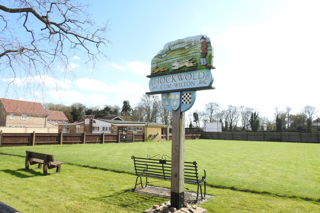
Hockwold cum Wilton village sign
Hockwold cum Wilton's sign is located at the bowls green. It depicts the two churches, on the left, the church of Wilton St James and its rare 14th century spire. On the right is the now redundant church of St Peter, Hockwold. The stream depicts the Little Ouse, which is the southern boundary of the parishes and the county. In the foreground are a hare, two dogs and their handler, recalling the activities of the widely known Hockwold Coursing Club (1920-1939). Below the name, are three devices. Three bee skeps relate to the 17 mentioned in the Domesday Book. The wool sacks recall the days of the 15th and 16th century wool industry. Finally, the chequerboard pattern symbolises the blue and gold arms of Earl William de Warenne who held much land in the area after Domesday.
The previous sign also bore six loaves of bread and acorns. The loaves represented an early charity when six loaves were provided weekly for six poor Protestants, and the acorns represented the 'pannage for 200 hogs and 30 goats'. Link
The previous sign also bore six loaves of bread and acorns. The loaves represented an early charity when six loaves were provided weekly for six poor Protestants, and the acorns represented the 'pannage for 200 hogs and 30 goats'. Link
Village Signs of East Anglia
Village signs are typically placed along the principal road or in a prominent location such as a village green or close by the church. The design often depicts a particularly feature of the village or a scene from its history, heritage, or culture. They are typically made of wood or metal or a combination of both, the designs are often made by the local community.
Although they do appear in villages and towns all over the country they are more prominent in East Anglia than elsewhere in the country.
 Map © Crown Copyright")
TIP: Click the map for more Large scale mapping
- Grid Square
- TL7388, 82 images (more nearby 🔍)
- Photographer
- Adrian S Pye (more nearby)
- Date Taken
- Monday, 29 March, 2021 (more nearby)
- Submitted
- Thursday, 1 April, 2021
- Subject Location
-
OSGB36:
 TL 7314 8811 [10m precision]
WGS84: 52:27.8088N 0:32.8298E - Camera Location
-
OSGB36: TL 7314 8811
- View Direction
- South-southeast (about 157 degrees)