2021
TF9717 : Beetley village sign and millennium clock
taken 3 years ago, near to Beetley, Norfolk, England
The Geograph Britain and Ireland project aims to collect geographically representative photographs and information for every square kilometre of Great Britain and Ireland.
Read about the Geograph Project.
Read about the Geograph Project.
We have at least 1 images that match your query [https://www..org.uk//6796350] in the area! View them now
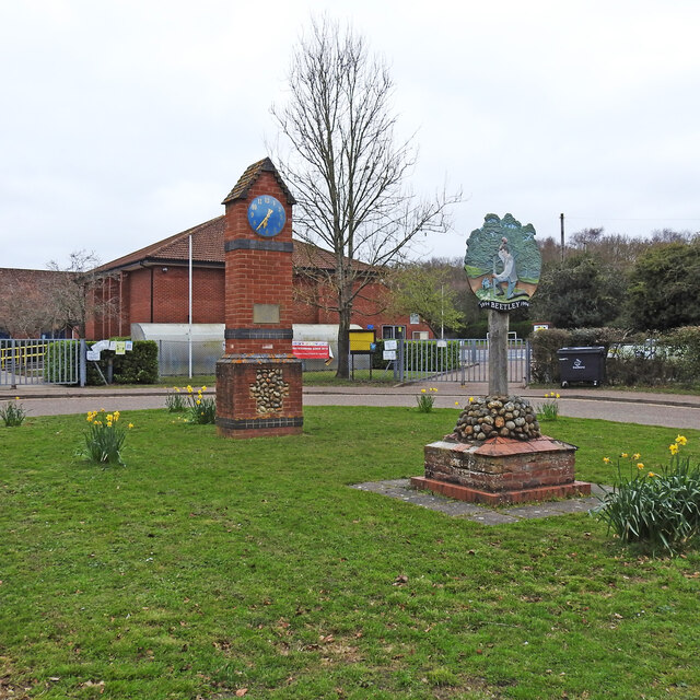
Beetley village sign and millennium clock
The sign shows a woodsman, using a wooden mallet to drive a stake into the ground. The Anglo-Saxon word for a mallet is betel, and the many hardwood trees in the area made it a good place to manufacture and produce these tools. Hence it became known as Beetley. This sign was erected for a village centenary in 1994, not quite sure what of though. Link
Village Signs of East Anglia
Village signs are typically placed along the principal road or in a prominent location such as a village green or close by the church. The design often depicts a particularly feature of the village or a scene from its history, heritage, or culture. They are typically made of wood or metal or a combination of both, the designs are often made by the local community.
Although they do appear in villages and towns all over the country they are more prominent in East Anglia than elsewhere in the country.
 Map © Crown Copyright")
TIP: Click the map for more Large scale mapping
- Grid Square
- TF9717, 68 images (more nearby 🔍)
- Photographer
- Adrian S Pye (more nearby)
- Date Taken
- Saturday, 3 April, 2021 (more nearby)
- Submitted
- Sunday, 4 April, 2021
- Subject Location
-
OSGB36:
 TF 97404 17325 [1m precision]
WGS84: 52:43.0533N 0:55.2755E - Camera Location
-
OSGB36: TF 9741 1731
- View Direction
- North-northwest (about 337 degrees)