
Afyonkarahisar Pictures, Images and Stock Photos
Browse 1,600+ afyonkarahisar stock photos and images available, or start a new search to explore more stock photos and images.
Most popular
View from drone of residential districts of Turkish city of Afyonkarahisar overlooking lighted streets and volcanic rock with ancient castle on top on winter evening

View from drone of residential districts of Turkish city of Afyonkarahisar overlooking volcanic rock with ancient ruined castle on top on winter day, Afyon Province
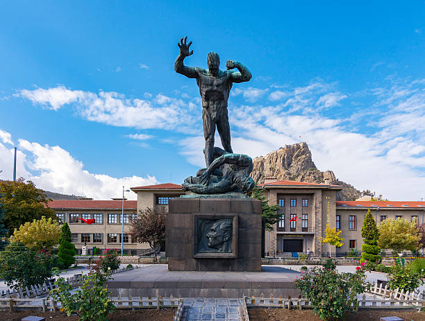
Afyon, Turkey - October 08, 2016 : Afyon Ataturk Buyuk Utku Monument view. Afyon is located center of Anatolia.

Supreme commander Mustafa Kemal Atatürk and his friends come to Kocatepe at 25th August 1922. They intiated "Great Offensive" at that morning in there.

Townscape, Afyon in Turkey.
Afyonkarahisar is a city in western Turkey, the capital of Afyon Province.

Turkish famous traditional pastry (borek). Afyon (Afyonkarahisar) city special cuisine, it's called "mouth open patty". Turkish cuisine, borek, pastries, recipes, traditional tastes concept. Horizontal close-up on white background.

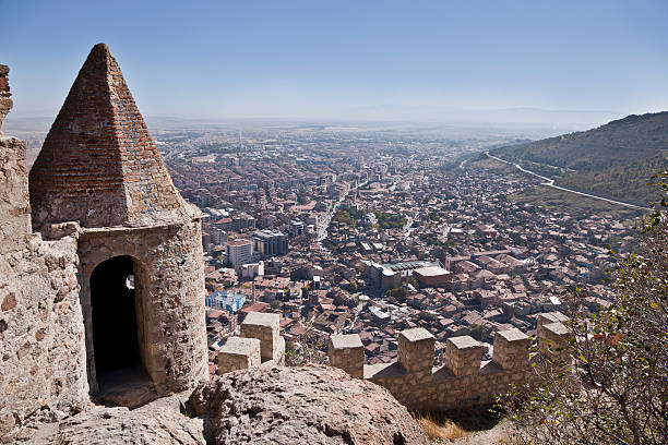
Historic Afyonkarahisar streets, Karahisar castle, Historic Afyon houses and Grand Mosque (Turkish; Ulu cami ) Turkey travel destinations


Drone view of the residential areas of Afyonkarahisar near the Rock with the fortress, Turkey.

Afyon fort on the top of the hill.


AFYONKARAHISAR,TURKEY,FEBRUARY 5,2019: Mevlevi mosque view in Afyonkarahisar. Mosque is one of the most important holly places after Konya. Afyonkarahisar is a city in western Turkey, the capital of Afyon Province.

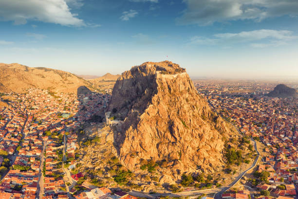
Afyonkarahisar Castle, located on a volcanic rock mass. The castle was used by various civilizations. Afyonkarahisar, Turkey.

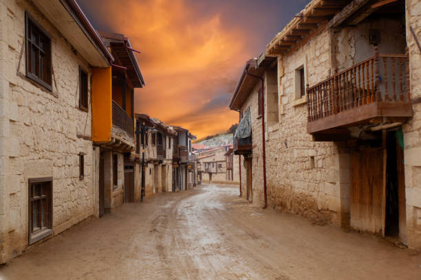
Afyonkarahisar ,TURKEY-May 14,2018: Beautiful old street in downtown with houses with wooden shutters in the classic Turkish Ottoman style, The two-storey buildings .

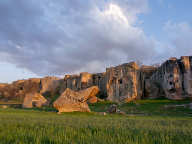
frig valley, frigler, frigya, Phrygians, Phrygia, frig vadisi

Phrygian Valley is historical place in Afyonkarahisar, Turkey.

"Aerial view of Afyonkarahisar, Turkey."

The ancient church from the Phrygian valley located between two turkish cities Afyon and Eskisehir

Cartoon Map Afyon https://maps.lib.utexas.edu/maps/middle_east_and_asia/turkey_republic_2002.html

Afyonkarahisar - Turkey

Afyonkarahisar iscehisar, ihsaniye, sincanli, hocalar, sandikli, kiziloren, evciler, dazkiri, basmakci, dinar, suhut, cobanlar, cay, bolvadin, sultandagi, emirdag, bayat map, Turkey

Cartoon Map of Afyonkarahisar; https://maps.lib.utexas.edu/maps/middle_east_and_asia/turkey_republic_2002.html

frig valley, frigler, frigya, Phrygians, goddess Cybele, frig vadisi

aerial view of the Afyonkarahisar cityscape and castle on the top of the mountain.


frig valley, frigler, frigya, Phrygians, Phrygia, frig vadisi

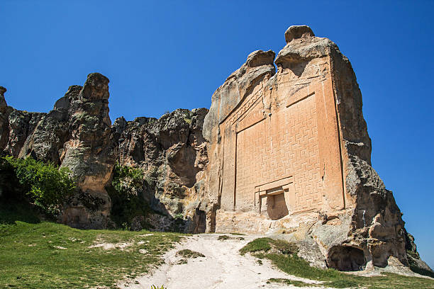
AYAZİNİ KİLİSESİ: İhsaniye İlçesi, Ayazini Kasabası girişinde yol kenarında tüf sarp kayalık içinde, kayaya oyulmuş bir kilisedir. Çevresine bitişik kaya odalarıyla birlikte 1000’li yıllarda yapılmış manastır yapısıdır.

Phrygian Valley in Ayazini.Phrygian Valley is a historical region with caves and stone houses dating back thousands of years.


Cartoon Map of Afyonkarahisar; https://maps.lib.utexas.edu/maps/middle_east_and_asia/turkey_republic_2002.html

frig valley, frigler, frigya, Phrygians, Phrygia, frig vadisi

Ihsaniye, Afyonkarahisar/Turkey-June 08 2019: Phrygia Valley Natural Park (Frig Vadisi Tabiat Parki) with Lake Emre

Map of Turkey where Afyonkarahisar province is pulled out, isolated on white background

Turkey map vector outline with scales of miles and kilometers and borders of provinces

Aerial view of Afyonkarahisar city with Afyon castle on the rock in the evening, Turkey

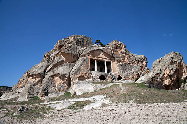
Historical ancient the acropolis of Phrygia, in Kumbet village, Eskisehir.Turkey

Yazilikaya , Midas Monument . Phrygia valley in the middle of Kutahya, Eskisehir, Afyon in Turkey.

Opium Field near Afyonkarahisar City in Turkey

Turkey country map outline vector illustration with scales of miles and kilometers, borders of states or provinces and their names, and capital location and name, Ankara

Turkey map vector outline with borders of provinces or states. Map reference: http://www.lib.utexas.edu/maps. The map is accurately prepared by a GIS expert.
The other name is Lion Sanctuary. Snake stone.Phrygia Valley.

Phrygians are one of the Trak tribes migrated from Thrace to Anatolia. According to the general consent, Trak migration started from 1200 B.C. and lasted almost 400 years centered mostly in the period following the decadence of Hittite Empire. Having invaded Troia and surrounding, Phrygians spread over the shores of Askania Lake (Iznik Lake) and Sangarius River Valley (Sakarya River Valley) and continued to disperse into Anatolia. They established a powerful state in the Central Anatolia between the 9th and 6th c. B.C. Phrygia was divided into two regions in the ancient times. “Phrygia Megale” covering the area between Red River in the east, Lidia region in the west, Lakonya in the south and Köroğlu Mountains in the north; “Phrygia Micra” or “Phrygia Epiktetus” the region covering the provinces of Eskişehir, Afyonkarahisar and Kütahya today. The latter is also called Mountainous Phrygia as it is an upland mountainous area which is constituted by deep valleys and volcanic tuff rocks. Phrygians settled their sacred places and cult centers in such highland areas as they believed Goddess Kybele appears in bare cliffs, valleys and mountains near to freshwater bodies. As a result, it is the Mountainous Phrygia region, which encompasses nearly 52 ha. area, where the Phrygians had their most powerful political and cultural dominance throughout their history.

Afyonkarahisar Ulu Mosque was built in the 13th century. It contains all the features of wood art.

Phrygian Valley.


Ancient rock tombs. Inscriptions written on rocks centuries ago. Phrygian valley. The ancient city of Phrygia. Ancient tombs in the mountains. Selective focus.

Ihsaniye, Afyonkarahisar/Turkey-June 08 2019: The entrance of Phrygia Valley Natural Park (Frig Vadisi Tabiat Parki), Phrygia Valley National Park

The monumental statue and flag in Kocatepe in Afyonkarahisar, where the great offensive was started during the War of Independence and directed by Atatürk.

The castle, which dates back to 1350 BC, was used by various civilizations
The other name is Lion Sanctuary.Snake stone.Phrigia Valley.

Ihsaniye, Afyonkarahisar/Turkey-June 08 2019: Phrygia Valley Natural Park (Frig Vadisi Tabiat Parki) with Lake Emre

View from drone of residential districts of Turkish city of Afyonkarahisar on winter evening, Afyon Province

view to the rock formations in shape of two lions in Phrygian Valley in Afyon, it is representation of old tombstones made by ancient Phrygian people that lived in an area of Afyon. Now this place is a ruin and remains of that anciant civilization

Phrigia Valley.

frig valley, frigler, frigya, Phrygians, Phrygia, frig vadisi
Next