


<< Our Photo Pages >> Gilsland Spa Well - Holy Well or Sacred Spring in England in Northumberland
Submitted by Anne T on Wednesday, 28 August 2019 Page Views: 3079
Springs and Holy WellsSite Name: Gilsland Spa WellCountry: England County: Northumberland Type: Holy Well or Sacred Spring
Nearest Town: Brampton / Haltwhistle Nearest Village: Gilsland Spa
Map Ref: NY6354067815
Latitude: 55.003558N Longitude: 2.571538W
Condition:
| 5 | Perfect |
| 4 | Almost Perfect |
| 3 | Reasonable but with some damage |
| 2 | Ruined but still recognisable as an ancient site |
| 1 | Pretty much destroyed, possibly visible as crop marks |
| 0 | No data. |
| -1 | Completely destroyed |
| 5 | Superb |
| 4 | Good |
| 3 | Ordinary |
| 2 | Not Good |
| 1 | Awful |
| 0 | No data. |
| 5 | Can be driven to, probably with disabled access |
| 4 | Short walk on a footpath |
| 3 | Requiring a bit more of a walk |
| 2 | A long walk |
| 1 | In the middle of nowhere, a nightmare to find |
| 0 | No data. |
| 5 | co-ordinates taken by GPS or official recorded co-ordinates |
| 4 | co-ordinates scaled from a detailed map |
| 3 | co-ordinates scaled from a bad map |
| 2 | co-ordinates of the nearest village |
| 1 | co-ordinates of the nearest town |
| 0 | no data |
Internal Links:
External Links:
I have visited· I would like to visit
RedKite1985 visited on 17th Sep 2019 - their rating: Cond: 4 Amb: 4 Access: 4
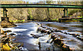
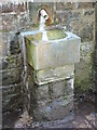
Anne T visited on 27th Aug 2019 - their rating: Cond: 3 Amb: 3 Access: 4 Gilsland Spa Well: From the hotel car park, we followed the signs for the Sulphur Spa, leading on a path with a steep drop to our right hand side down to the River Irthing below. The path winds round to the left, then splits just above the southern side of the footbridge across the river. Take the right hand fork, walk about 20m, then take the small flight of steps down to the well, which can be smelt well in advance of reaching it!
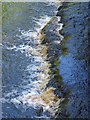
The ground was very wet, with a steady flow of water coming out of the well spout. The eastern side of the well basin was covered with a white sulphurous stain, which carried on with the flow of water overflowing from the basin down to the river. I did dip my finger into the running water and had a quick taste. Very sulphurous, but not really unpleasant
As we approached the well, another couple were making a beeline from the well, coming from a path to the east. We fell into conversation, and it turned out they were from Doncaster (which is where I lived my early life), and lived near the race course. They were staying at the hotel for a week, returning home on Friday.
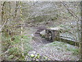
The path leading west from the well and the footbridge had been eroded away by the river. We got to within 120m of the sulphur spring, but not even Andrew wanted to walk this section of path; he said it would have been easier to walk along the river bed. We did try and see it from the other side of the river, but it was too heavily wooded to see anything.
This well is mentioned only briefly in the Springs of Living Water book by Fr John Muster, page 80, under the small section headed ‘Spa Wells’: “Though called holy wells, none are ever found identified with a saint. A good example is the one at Gilsland”. They have a photo on page 86.
No entries on Pastscape or HE, although if you type in the grid reference to the HE map search, it shows a circle where this well is located, and calls the general area to the west of the well a ‘Sulphur Spring’.
Average ratings for this site from all visit loggers: Condition: 3.5 Ambience: 3.5 Access: 4
")
.
Parking in the small car park to the southern side of the Gilsland Spa Hotel, paths lead to Woodland Walks, the Irthing Gorge Walk and the Sulphur Spa. Taking the path signposted 'Sulphur Spa', the path slopes down at about a thirty degree angle, with a steep drop to the river below to your right hand side as you descend [note: it's perhaps not for people with a fear of heights (although with good walking boots, my walking poles, and husband on my right hand side to make sure I didn't tumble (!) I managed nicely].
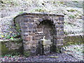
The spring emerges at the base of a cliff into a relatively modern-looking stone built well house, complete with modern pipe/spout and basin. The water which overflows the basin trickles across the ground into the River Irthing, just to the east of the footbridge across the river.
The Gazetteer quotes from "Description of Scenery in the Lake District" by William Ford (1843 edition, page 115: "The smell is so strongly impregnated with sulphur as to extend to the distance of several yards. It was originally known by the name of the Holy Well, also by that of Wardrew Spa, the latter name being taken from the tenement and farm on the Northumberland side of the water". The water, in Ford's time was recommended as a cure for various illnesses (although what, was not specified), and was to be 'taken in moderation'.
The path is supposed to continue along the side of the river to the spa, and a second well, although parts of this have now been washed away (see the Gilsland Spa Sulphur Spring in the nearby sites list below).
You may be viewing yesterday's version of this page. To see the most up to date information please register for a free account.
")
")
")
Do not use the above information on other web sites or publications without permission of the contributor.
Nearby Images from Geograph Britain and Ireland:
©2016(licence)
©2012(licence)
©2015(licence)
©2015(licence)
©2015(licence)
The above images may not be of the site on this page, they are loaded from Geograph.
Please Submit an Image of this site or go out and take one for us!
Click here to see more info for this site
Nearby sites
Key: Red: member's photo, Blue: 3rd party photo, Yellow: other image, Green: no photo - please go there and take one, Grey: site destroyed
Download sites to:
KML (Google Earth)
GPX (GPS waypoints)
CSV (Garmin/Navman)
CSV (Excel)
To unlock full downloads you need to sign up as a Contributory Member. Otherwise downloads are limited to 50 sites.
Turn off the page maps and other distractions
Nearby sites listing. In the following links * = Image available
89m SW 231° Gilsland Spa Sulphur Spring Holy Well or Sacred Spring (NY63476776)
335m N 1° Popping Stone* Natural Stone / Erratic / Other Natural Feature (NY63556815)
1.6km S 184° Hadrian's Wall (Poltross Burn)* Stone Fort or Dun (NY6340166198)
4.1km W 277° Waterhead Holy Well (King Water)* Holy Well or Sacred Spring (NY5951068340)
4.3km NNE 14° Standingstone Rigg Standing Stone (Cumbria) Standing Stone (Menhir) (NY6458271969)
4.7km ESE 104° King Arthur's Well (Walltown Gap)* Holy Well or Sacred Spring (NY68066664)
4.7km ESE 103° Hadrian's Wall (Turret 44b)* Misc. Earthwork (NY6813866704)
6.5km S 177° Hartleyburn Common 1c Rock Art (NY6387161326)
6.5km S 177° Hartleyburn Common 1d Rock Art (NY6387361324)
6.5km S 177° Hartleyburn Common 1a* Rock Art (NY6387261311)
6.5km S 177° Hartleyburn Common 1b Rock Art (NY6384861302)
6.6km S 178° Hartleyburn Common 1e* Rock Art (NY6377261261)
6.6km S 178° The Curricks* Ancient Village or Settlement (NY63746122)
6.6km S 178° Hartleyburn Common 2 Rock Art (NY6370061200)
6.8km E 101° Aesica Vallum Round Barrow* Round Barrow(s) (NY70196650)
6.8km S 176° Hartleyburn Common 5* Rock Art (NY6396961024)
6.9km WSW 243° Banks East Ancient Village or Settlement (NY574647)
6.9km E 98° Aescia Roman Fort* Stone Fort or Dun (NY7036566800)
7.0km WNW 302° Robin Hood's Well (Askerton) Holy Well or Sacred Spring (NY57677161)
7.1km WNW 294° Gillalees Ring Cairn (NY571708)
7.3km S 175° Hartleyburn Common 3* Rock Art (NY6412160581)
7.4km S 176° Hartleyburn Common 4 Rock Art (NY6398460470)
7.4km S 174° Haining House (Lambley)* Cairn (NY64296042)
8.0km NW 321° Woodhead Round Cairn* Round Cairn (NY58507402)
8.1km E 85° Ventner's Hall Cairn (1)* Cairn (NY71696841)
View more nearby sites and additional images


 We would like to know more about this location. Please feel free to add a brief description and any relevant information in your own language.
 Wir möchten mehr über diese Stätte erfahren. Bitte zögern Sie nicht, eine kurze Beschreibung und relevante Informationen in Deutsch hinzuzufügen.
 Nous aimerions en savoir encore un peu sur les lieux. S'il vous plaît n'hesitez pas à ajouter une courte description et tous les renseignements pertinents dans votre propre langue.
 Quisieramos informarnos un poco más de las lugares. No dude en añadir una breve descripción y otros datos relevantes en su propio idioma.