Introduction
Halswell House has mid- to late-18th-century landscaped pleasure grounds of around 27 hectares set within a park. There is a series of landscape buildings attributed to Thomas Wright.
Terrain
Halswell Park occupies a north-facing slope of the Quantock Hills, with a deep combe, Huntstile Bottom, running from south to north c 800m east of the House, and a wider, shallower valley running north from Patcombe.
The following is from the Register of Parks and Gardens of Special Historic Interest. For the most up-to-date Register entry, please visit The National Heritage List for England (NHLE):
Mid- and late-18th-century pleasure grounds and parkland which were developed from early 18th-century formal gardens and parkland by Sir Charles Tynte, with a series of landscape buildings attributed to Thomas Wright.
Location, Area, Boundaries, Landform and Setting
Halswell Park is situated immediately to the south of the village of Goathurst, some 3km south-west of Bridgwater. The c 179ha site comprises of gardens and pleasure grounds around the House, an area of mid C18 pleasure grounds in a combe known as Patcombe and Mill Wood c 400m north-west of the House, and parkland and ornamental plantations. To the north the site is bounded by the village of Goathurst, and by a minor sunken road which runs east from Huntstile to Goathurst and west to Andersfield. The west boundary is formed by a further minor sunken road which runs south from Andersfield to Hatcombe. To the south and east the site adjoins agricultural land and a late C20 commercial plantation which adjoins an C18 boundary plantation, The Thickets, south of the House.
Halswell Park occupies a north-facing slope of the Quantock Hills, with a deep combe, Huntstile Bottom, running from south to north c 800m east of the House, and a wider, shallower valley running north from Patcombe c 750m south-west of the House, to Mill Wood c 350m west of the House. The site enjoys extensive views north across adjoining agricultural land to the Bristol Channel, Flat Holm, Steep Holm, and the South Wales coast. There are significant designed views north across the park, pleasure grounds, and surrounding land towards the Keymes' property in South Wales from Robin Hood's Hut which stands on the ridge of high ground c 400m south of the House. Ornamental clumps of trees and other planting on land to the south of The Thickets and to the north of the minor road which passes through Rooks Castle Farm c 1km south of the House are significant for the setting of the site, but are excluded from the site here registered.
Entrances and Approaches
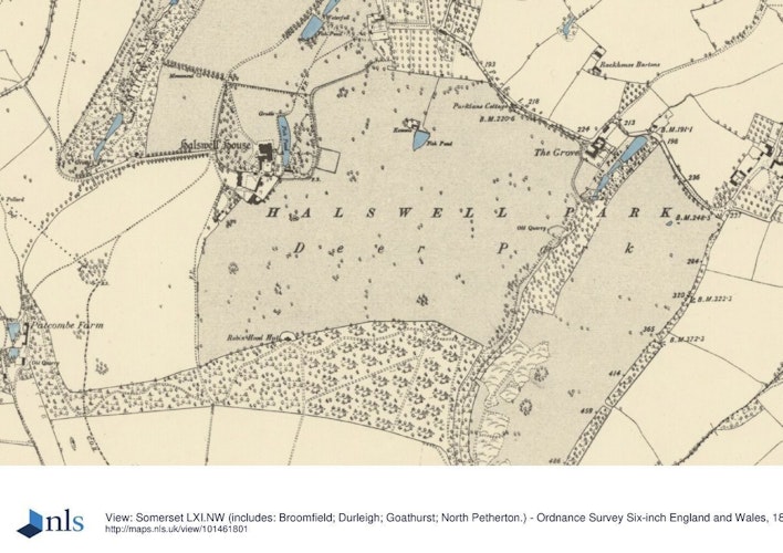
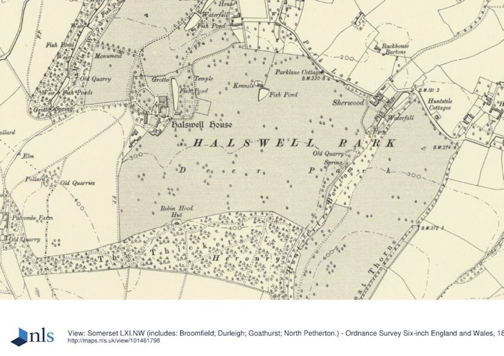
Halswell Park is approached from the principal street of Goathurst, which lies immediately to the north of the park. The mid C18 entrance is formed by low concave wing walls of stone construction surmounted by ornamental wrought-iron railings which flank a pair of square-section stone gate piers with pyramidal caps. A single-storey rustic thatched lodge (listed grade II) built c 1825 to replace an earlier structure stands within the site and immediately to the east of the entrance. The lodge is set in late C20 gardens enclosed by timber fences. The concrete and tarmac drive enters the park and runs for c 250m south-south-west through the remnants of an avenue of lime trees. To the south of the drive and avenue two fishponds survive.
The longer, northern pond is of mid C18 construction and is separated from the earlier, higher pond by a rustic stone cascade set into a dam which carries a service drive south-east and east from the main drive to the kitchen garden. The ponds are now (1999) silted and overgrown. The principal drive continues for c 250m south-west across the park, before turning sharply south-south-east as it enters the pleasure grounds around the House. Screened by mature shrubbery and woodland to the west and adjoining lawns to the east, the drive sweeps south-south-east and south-east for c 250m to approach the north-west corner of the House and a gravelled carriage court below the west façade. A narrow gravelled drive extends to the front door in the centre of the north façade, while a service drive leads south-west from the carriage court for c 30m to reach the stable court. Immediately to the west of the service drive stands a mid C18 stepped pyramidal structure surmounted by a carved stone gryphon (listed grade II) which covers a well and contains an inscription honouring the 'pure nymph'; this formed part of Sir Charles Tynte's mid C18 improvements to the pleasure grounds.
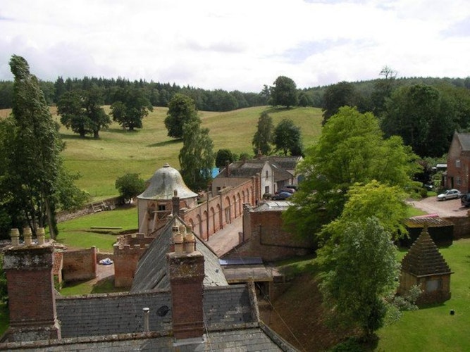
The stable court is entered through plain wrought-iron gates with spear finials which are supported by stone piers with pyramidal caps, flanked by high brick walls (listed grade II). To the east, the wall adjoins a mid C18 brick coach house (listed grade II) with a crenellated parapet, while to the south the court is enclosed by the west façade of the riding school (listed grade II), a red-brick structure designed by John Johnson in 1769. To the east of the riding school stands a circular dovecote of cob construction under an ogee tiled roof (listed grade II), while a further coach house to the south of the riding school completes an almost symmetrical composition. To the west, the stable yard is partly enclosed by a range of two-storey stone cottages of mid C18 origin, with a central gothic arch flanked by a pair of short crenellated turrets. The stable cottages, coach house, and riding school were all converted into dwellings in the mid C20.
Principal Building
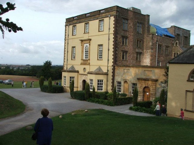
Halswell House (listed grade I; Buildings at Risk Register 1999) comprises a south range built in the C16 for Sir Nicholas Halswell, and a monumental north range built for Sir Halswell Tynte in 1689 to designs by William Taylor, a London surveyor who made alterations at Longleat, Wiltshire (qv) (CL 1989). The baroque north façade is of three storeys with a flat roof concealed by a balustrade, all constructed in Ham Hill stone. The central doorway is set within a niche, while the window above is flanked by pilasters and surmounted by a pediment and carved coat of arms. The recessed centre of the north façade is enclosed by slightly projecting two-bay wings to the east and west. The east façade comprises a five-bay return of the north range, beyond which stands the irregular two-storey gabled south range under a pitched slate roof. To the west the north range returns with a doorway flanked by niches, while a screen wall conceals the service quarters in the south range.
Gardens and Pleasure Grounds
The pleasure grounds comprise three distinct areas, linked by rides and drives through the parkland: the pleasure grounds around the House, Patcombe c 900m south-west of the House, and Mill Wood c 500m north-west of the House.
To the north of the House, lawns slope gently down to a late C19 stone ha-ha which separates the pleasure grounds from the park. This replaced an earlier ha-ha which lay some 80m to the north. To the east and north-east of the House a grass bank descends to a level lawn in which a roughly rectangular canal runs c 100m from south to north, some 30m east of the House. This canal is of mid C18 origin, forming part of Sir Charles Tynte's remodelling of the early C18 formal garden and sunken parterre shown in a painting of c 1710 (private collection); it is shown in its present form on an estate plan of 1756, although late C18 views suggest that it had a more serpentine appearance (Watt, 1779; Collinson 1791). The dam to the north of the canal has an elaborate rockwork screen on its outer face which was built c 1754 (Escott Memorandum).
A pair of lower pedimented bays with shallow stone-paved arched recesses flank a taller, central pedimented and arched recess which contains the remains of a stone bench seat and an inscription tablet let into the rear wall (inscription missing, 1999). The central recess is separated from the flanking bays by linking walls of ashlar, inset with arched niches. The pediments of each bay are supported on rusticated stone piers, now (1999) much decayed. The rockwork screen now faces the park to the north of the pleasure grounds, but in the mid C18 had a circular pool immediately to the north (Wilstar, 1756). To the east of the canal, the rising ground is planted with young trees, laurels, and mature specimen trees through which a network of walks survives. Some 100m north-east of the House, a mid C18 stone rotunda (listed grade II) stands on a mound which contains an icehouse. Escott, the estate steward, records that the rotunda, or 'Mrs Busby's temple on the lawn', named for Lady Tynte's sister, was built in 1755 (Escott Memorandum); its design has been attributed by Gervase Jackson-Stops to Thomas Wright (CL 1989).
Vistas to and from the rotunda from the park and other points in the pleasure grounds are today (1999) largely obscured by trees, while the structure itself is under restoration. The pleasure grounds are enclosed to the east and south by a ha-ha which separates them from the park. To the west of the drive an area of trees and shrubbery is separated from the park by a stone ha-ha of C18 origin (Pearson Assocs 1995), while two avenues extend west and north-west across the park to link with the detached areas of pleasure ground at Patcombe and Mill Wood. A clairvoie set in the western boundary c l00m west of the House was built in 1769, allowing a vista from the pleasure grounds, along the west avenue to the southern end of Mill Wood, whence a drive ran south-west through the park to Patcombe.
The clairvoie survives (1999), although the views through it have been planted out and the avenue beyond felled. The north-west avenue led from the point at which the drive entered the pleasure grounds c 240m across the park to enter the east side of Mill Wood, passing a monument to Sir Charles' favourite horse which stood c 320m north-west of the House. Constructed in 1765, the monument comprised a double sarcophagus, a smaller one placed above a larger one, and reflected the design of Thomas Wright's monument to the fourth Duke of Beaufort at Stoke Park, Bristol (qv), which had been built in 1756. The monument was demolished and removed c 1950 (CL 1989; Pearson Assocs 1995).
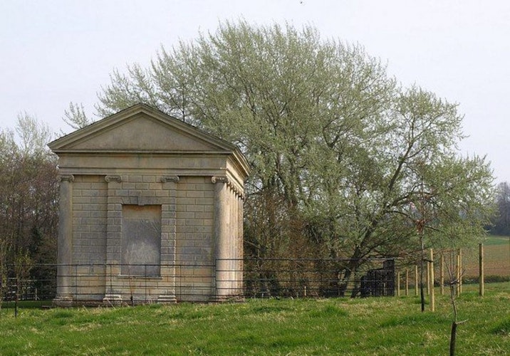
The detached pleasure grounds at Patcombe c 750m south-west of the House were developed in the 1770s. Situated at the head of a shallow combe which descends north to Mill Wood, Patcombe comprises a group of ornamental and agricultural buildings arranged above two ponds. The bailiff's house or Temple of Pan (listed grade II*) was built in 1771 (Escott Memorandum), possibly to the design of John Johnson, who in 1778 exhibited a drawing for a 'Temple of Pan in the Gardens of Sir Charles Kemeys... at Haswell' at the Society of Artists (CL 1989). The Temple is a brick structure under a pantiled roof which stands on a grass terrace set into the east side of the valley, with an ornamental façade facing north, down the valley. This ornamental façade has a single-storey semicircular alcove and projecting classical colonnade, flanked by arched recesses containing sash windows. The small pediment above the colonnade contains an oeil-de-boeuf window. The structure was restored and converted to domestic use in 1997-8, with a new range being built at the south-east corner of the original building, on the site of the C18 kitchen.
Some 100m to the south of the Temple of Pan, on the east side of the valley, a mid C18 two-storey stone barn has an ornamental west façade comprising an open arcade at ground level, with a similar blind arcade above; this structure was converted to domestic use in 1998-9. Some 30m north-north-west of the Temple of Pan, a mid C18 lead statue of Pan stood on a grassy knoll retained by a drystone wall. The stone wall survives (1999), but the statue was removed to Castle Hill, Devon (qv) in the mid C20. The plantation enclosing the head of the combe and extending The Thicket was planted in 1772 (Escott Memorandum), and today (1999) the Temple of Pan and its associated buildings are framed by the C18 plantation and enjoy pastoral views north-north-west across the parkland in the upper valley. A drive, first constructed in 1770 (ibid), leads c 650m north-west along the west side of the valley to join a minor road to the west of the park. Mill Wood is today (1999) an area of open meadow occupying the bottom of the shallow valley c 600m north-east of Patcombe, and c 350m west of Halswell House. A stream, fed from the ponds in Patcombe, is dammed to form a chain of six ponds linked by cascades and other ornamental structures. Other mid C18 ornamental buildings constructed by Sir Charles Tynte in Mill Wood have largely been lost in the C20, and the ornamental planting including ilex oaks, sweet chestnuts, and firs (Escott Memorandum) was felled c 1950 (Pearson Assocs 1995). The Mill Wood pleasure ground appears to have been developed in the 1750s from an existing area of woodland and was intended to stimulate a variety of emotional responses in the visitor (Young 1771; CL 1989), with contrasting 'gloomy', 'silent', and 'cheerful' areas. Sir Charles Tynte's diary for 1756 records the stocking of the pools in Mill Wood with goldfish, trout, and gudgeon.
The stream emerges at the head of Mill Wood in a semicircular grotto comprising three rustic stone arches and recesses, that to the south-east containing a well-head and flanked by an inscription referring to Moses drawing water from a rock. The south-west recess contains a series of stone shelves. The stream flows from the pool below the grotto into the second pool via a rustic stone cascade. To the west of the second pool is an early C20 hydraulic ram. At the lower or northern end of the second pool the dam is disguised as an ornamental bridge (listed grade II) which was constructed in Bath stone in 1755 for Sir Charles Tynte. The design of this structure has been attributed to Thomas Wright (CL 1989), and it comprises a balustraded north wall which rises to a central, shallow semicircular-headed niche with vermiculated keystones and imposts. The structure is now in a poor condition with unsympathetic mid C20 repairs to the south parapet which projects in a shallow bow opposite the north recess. Two round-headed arches feed the water from the pond to a rustic stone cascade on the north side of the dam.
The third pool is today (1999) divided into two pools by a mid C20 concrete dam, to the east of which stands a mid C20 derelict brick pump house. At the north end of what is now the fourth pool, the water flows through the ruins of a tall, rustic stone-arched structure which originally contained a statue of Neptune (ibid). Only the eastern pier of the arch survives today. The two lowest pools are separated by a low, bridge-like structure with three arched openings which feed a stepped stone cascade, while the dam of the lowest pool supports a carriage drive which runs east, parallel to the minor road forming the northern site boundary, to return to the House through the park. Brick and stone gate piers mark the boundary of Mill Wood. To the west of the lowest pool, and c 450m north-west of the House, stands the Temple of Harmony (listed grade II*), a structure with pedimental east and west gables, that to the east which faces Halswell House being supported by Ionic columns. The side walls are of rusticated masonry, with attached Ionic columns supporting the architrave. The Temple of Harmony was erected in 1764-5 (Escott Memorandum), to the design of Thomas Prowse, a gentleman amateur architect and friend of Sir Charles Tynte, who also worked at Hatch Court, Somerset (qv). The Temple was dedicated to the memory of a mutual friend, Peregrine Palmer, formerly MP for Oxford University (d 1762), and Prowse's final design may have been based on an earlier scheme by Robert Adam (CL 1989; Pearson Assocs 1995). Following Prowse's death in 1767, a marble statue of Harmony was dedicated to his memory and installed in an aedicule designed by Adam in the west wall of the Temple. The structure was restored in the 1990s and the original statue of Harmony carved by John Walsh is now (1999) displayed in Taunton Museum, with a replica being placed in the Temple.
Mill Wood contained further structures which are now lost. These included the Druid's Temple, a rustic timber octagonal building with a pyramidal roof which stood c 400m south-west of the Temple of Harmony and to the west of the top pool. The design of the Druid's Temple has been linked to the frontispiece of Thomas Wright's Book of Arbours (1755) (CL 1989; Pearson Assocs 1995), and the building at Halswell was constructed in 1756 by J J de Wilstar, a Bristol surveyor, architect, and builder (CL 1989).
Park
The park surrounds the House and pleasure grounds on all sides and is today (1999) in mixed agricultural use, with arable land around the House and to the east, and pasture to the west in Patcombe. Significant areas of boundary and other woodland survive in Huntstile Bottom to the east of the House, together with The Thickets, which is planted on the ridge of high ground to the south of the House. Many parkland trees were felled c 1950 (Pearson Assocs 1995), but in the areas of the park to the north and north-west of Patcombe, several old pollards survive, some of which have been dated to the mid C17 (ibid). Some sections of C19 wrought-iron deer fencing survive, dividing the park. A warren existed to the south of Goathurst village by the late C16, which formed the nucleus of the park. It assumed its present form in the mid and late C18 under Sir Charles Tynte, who in 1761 extended the park east to Huntstile Bottom c 800m south-east of the House (Escott Memorandum).
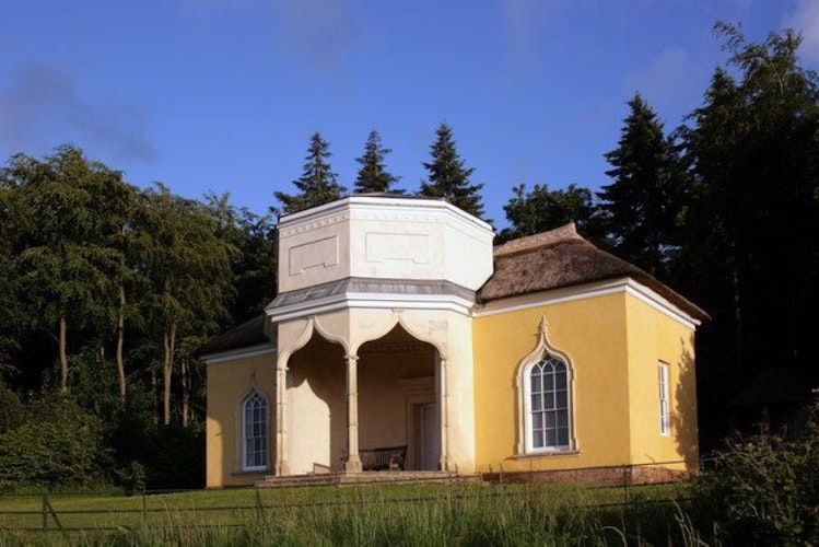
By 1802 the park had been extended further east to Great Thorns, c 1.2km east of the House (OS Surveyor's drawing). This late C18 or early C19 park extension had reverted to agricultural use by 1822 (Greenwood). Sir Charles Tynte created a circuit of rides which followed the north boundary of the park, passing south along the western edge of Huntstile Bottom before turning west through The Thickets, which were extended east in 1754 and 1761 (Escott Memorandum). Some 500m north-east of the House, the Lamb House is a single-storey agricultural structure which was provided with an ornamental façade in the mid C18, when it served as an eyecatcher in the view from Robin Hood's Hut. Robin Hood's Hut (listed grade II*) was built in 1765 (ibid), probably to the design of Henry Keene (CL 1989), and perhaps inspired by an earlier structure of the same name erected by Tynte's friend, John Aislabie at Studley Royal, Yorkshire (qv). Standing on the ridge of high ground c 450m south of the House, the Hut is approached from the south by the ride which runs through The Thicket, and today (1999) appears as a simple, colour-washed thatched cottage with a central gable and rustic timber door. Passing through the building, which was designed with a 'hermit's room' to the south with an adjoining kitchen and china closet, the visitor emerges into a canted gothic loggia on the north façade, with three gothic arches framing views across the park, the Bristol Channel, Steep Holm, and to Wales. The loggia is surmounted by a low, half-octagon turret, and flanked by a pair of gothic windows. Robin Hood's Hut was extensively restored and converted for occasional domestic use in 1997-8. In a shallow combe some 300m north of Robin Hood's Hut, and 100m south of the House, a C19 timber, square-plan and pyramid-roofed, formerly thatched structure stands among trees. This was a slaughterhouse associated with the management of deer in the park, and appears to have replaced an earlier structure for the same purpose on this site (Pearson Assocs 1995).
Kitchen Garden
Lying c 400m north-east of the House and today (1999) approached by a track leading from the principal drive, the kitchen garden is approximately square on plan and is enclosed by brick walls c 3m high. The walls are of buttressed construction, with pantile coping, and arched entrances lead into the garden from the south. The garden is of uncertain date, but existed in its present form by 1756 (Wilstar). The late C19 OS map (1889) shows a cruciform arrangement of walks within the garden, and glasshouses in an adjoining walled enclosure to the south-west. Today (1999) the garden is partly cultivated; late C20 tennis courts have been constructed adjacent to the north wall and the arrangement of walks is lost. A mid C20 house has been constructed to the south-west of the kitchen garden in the adjoining garden which is also enclosed by brick walls, with a C19 wrought-iron gate set in an opening in the west wall. A slip garden to the south of the kitchen garden survives, together with some trees from a C19 orchard (OS 1889).
Other Land
Sherwood, the former estate agent's house, stands c 800m east of the House, at the north-east corner of the mid C18 park. This property, and its associated barns and outbuildings, were ornamented by Sir Charles Tynte as part of his mid C18 improvements to the estate. The house, barns, gardens, and a chain of three ponds to the east of the house are included in the area here registered.
Maps
- J J de Wilstar, A Plan of the Halswell Estate, 1756 [copy on EH file]
- C and J Greenwood, Somersetshire Delineated, 1822
- Tithe map for Broomfield parish, 1838 (Somerset Record Office)
- Tithe map for Chilton Trinity parish, 1840 (Somerset Record Office)
- Tithe map for Goathurst parish, 1846 (Somerset Record Office)
- OS Surveyor's Drawing, 1802 (British Library Maps)
- OS Old Series 1" to 1 mile, published 1809
- OS 6" to 1 mile:
- 1st edition surveyed 1887, published 1890
- 2nd edition published 1904
- OS 25" to 1 mile: 1st edition surveyed 1888, published 1889
Illustrations
- Oil painting, The parterre, pavilion and vista seen from the north-east corner of Halswell House, c 1710 (private collection)
- Oil painting, Halswell House and pleasure grounds from the north, c 1750 (private collection)
- Henry Keene, design for Robin hood's Hut, c 1765 (Victoria and Albert Museum, London)
- John Inigo Richards, Halswell House and pleasure grounds from the north-east, c 1770 (private collection)
- W Watts after J I Richards, Halswell, in Somersetshire, the seat of Sir Charles Kemeys Tynte, Bart, 1779 (Somerset Record Office)
- Bonner, Halswell Park from the north-east showing the rotunda, canal and rockwork screen, 1791 (Somerset Record Office)
- A Aglis, Halswell House and pleasure grounds from the north-east, c 1820 (Local History Library, Taunton)
- J P Neale, Halswell House from the north-west, 1829 (Somerset Record Office)
- E Noyce, Halswell House from the north-west, c 1830 (Somerset Record Office)
- Engraving, View from the High Ground Halswell, c 1850 (Somerset Record Office)
- J Buckler, Halswell House from the north-east, 1863
Archival items
- The Tynte family archive, including Sir Charles Keymes Tynte's correspondence and diary for 1756 with references to work in Mill Wood and visitors to the gardens, is held at the Somerset Record Office (DID/X/ELS).
- R Escott, Memorandum to Sir Charles Tynte, with description of landscape work undertaken during Escott's period as estate steward, 1753-81 (DID/X/EMY 1), (Somerset Record Office)
- Survey of the Halswell Estate, 1597 (DID/X/ELS 1), (Somerset Record Office)
- Survey of the Estate of Sir John Tynte, 1708 (DID/X/ELS 1), (Somerset Record Office)
Description written: October 1999
Register Inspector: JML
Edited: November 2021
- Visitor Access, Directions & Contacts
- History
The following is from the Register of Parks and Gardens of Special Historic Interest. For the most up-to-date Register entry, please visit The National Heritage List for England (NHLE):
Historic Development
In the Saxon and Norman period, Halswell formed a distinct property within the heavily wooded parish of Goathurst (Victoria County History 1992). By the late 13th century Peter of Halswell held Halswell for one quarter knight’s fee, while in 1318 William Halswell was licensed to have mass celebrated in his private chapel. A receipt of 1536 for 'building the manor of Halswell’ may relate to the south range of the present mansion, and a late 16th-century survey indicates the existence of a warren, orchards, and bartons associated with the manor house (Pearson Associates 1995).
In 1603 Nicholas Halswell became MP for Bridgwater, and was subsequently knighted. Halswell was conveyed to his son Henry in 1628, and passed to Henry’s brother, Dr Hugh Halswell, a Proctor of Oxford University in 1636. The estate was placed in trust for Dr Halswell’s nephew, Halswell Tynte, whose mother was the daughter of Sir Nicholas Halswell who had married John Tynte of Chelvey Court around 1640.
Tynte inherited the property on the death of Dr Halswell in 1672, and the following year was granted a baronetcy. Sir Halswell Tynte settled at Halswell, and in 1689 completed the construction of a new Palladian wing to the north of the 16th- and 17th-century house. An early 18th-century painting (private collection) shows formal terraced gardens and parkland to the north-east of the House which were associated with the late 17th-century remodelling of the House.
Halswell was inherited in 1702 by Sir Halswell’s son, Sir John, who had married the heiress of Sir Charles Keymes of Cefan Mably, Glamorganshire. Sir John was succeeded in 1710 by his eldest son, Sir Halswell Tynte, who died in 1730, leaving the estate to his unmarried brother, the Rev John Tynte, Rector of Goathurst.
Sir John’s third son, Sir Charles Keymes Tynte, succeeded the Rev Sir John Tynte in 1740, and in 1747 inherited the Welsh properties belonging to his mother’s family. Sir Charles sat in Parliament as Member for Somerset until 1774, and was a leading figure in the county. He was a close associate of Coplestone Warre Bampfylde of Hestercombe, Somerset and Henry Hoare of Stourhead, Wiltshire (there are descriptions of both these sites elsewhere in the Register), sharing with them a taste for the embellishment of his estate.
A painting of around 1750 shows that the formal gardens around the House had been largely removed, and contemporary visitors' accounts refer to several ornamental structures, lakes, cascades, and well-wooded parkland. Richard Escott, appointed estate steward in 1753, wrote a detailed account of Sir Charles’ mid-18th-century improvements (Escott Memorandum). These included the extension of the park to the east and west of the House, and the construction of a series of ornamental structures in Mill Wood and elsewhere in the pleasure grounds, the design for several of which has been attributed by Gervase Jackson-Stops to Thomas Wright (Country Life 1989).
Halswell was extensively visited in the mid- and late 18th century, with a detailed description being written by Arthur Young in 1771. Work in the grounds at Halswell continued up to Sir Charles’ death in 1785, when the property passed to his widow, who remained in occupation until her own death in 1798. The estate was inherited by Sir Charles’ niece, Mrs Johnson (died 1825), who assumed the name Keymes Tynte but did not reside at Halswell; in 1821 Mrs Johnson’s son, Charles Keymes Tynte MP, was living at Halswell. The OS surveyor’s drawing of 1802 indicates that few changes were made to the landscape created by Sir Charles, a situation reflected on other 19th-century surveys.
Under Charles Keymes Tynte’s grandson the pleasure grounds in Mill Wood had declined (OS 1889), but in 1902 the 'noble and well-wooded park' was still stocked with a herd of fallow deer (Kelly’s Directory). The barony of Wharton was revived in favour of Charles T.H. Tynte in 1916, and in 1919 a herd of red deer was noted in the park at Halswell (Kelly's Directory).
Despite increasing financial problems, the north range of the House was restored to a high standard following a serious fire in 1923. By the early 1930s the estate was vested in Hoare’s Bank, and during the Second World War a prisoner of war camp was established in the grounds. The 9th Lord Wharton sold Halswell in 1950, and the estate was divided into several parts. Trees in the park and Mill Wood were felled and the stables and outbuildings divided into flats. The estate remains in divided private ownership today (1999). The Temple of Harmony and Robin Hood’s Hut were vested in the Halswell Park Trust in 1994, and were restored in 1996-9.
Period
- 18th Century (1701 to 1800)
- Late 18th Century (1775 to 1799)
- Associated People
- Features & Designations
Designations
The National Heritage List for England: Register of Parks and Gardens
- Reference: GD2149
- Grade: II
Features
- Lake
- Ha-ha
- Temple
- Folly
- Well House
- Ornamental Bridge
- Mansion (featured building)
- Description: A receipt of 1536 for 'building the manor of Halswell' may relate to the south range of the present mansion. The Palladian north wing was completed in 1689.
- Earliest Date:
- Latest Date:
- Key Information
Type
Estate
Purpose
Ornamental
Principal Building
Domestic / Residential
Period
18th Century (1701 to 1800)
Survival
Extant
Hectares
179
Open to the public
Yes
Civil Parish
Goathurst
- References
References
- {English Heritage Register of Parks and Gardens of Special Historic Interest}, (Swindon: English Heritage, 2008) [on CD-ROM] Historic England Register of Parks and Gardens of Special Historic Interest
- Harris, J., {The Artist and the Country House} {London: Russell Chambers, 1979), p. 282 The Artist and the Country House
- Bond, J., {Somerset Parks and Gardens} (Tiverton: Somerset Books, 1998), pp. 69, 86-7, 94, 97, 118, 120, 152-5 Somerset Parks and Gardens
- Pevsner, N., {The Buildings of England: South and West Somerset} (Harmondsworth: Penguin, 1958), pp. 188-9 The Buildings of England: South and West Somerset
- Nicholas Pearson Associates {Halswell Historic Landscape Survey/Management Plan} (1995) Halswell Historic Landscape Survey/Management Plan
- Nicholas Pearson Associates {Halswell (Mill Wood) Historic Landscape Survey} Halswell (Mill Wood) Historic Landscape Survey
- Wright, T., Arbours and Grottoes (1755-8, reprinted 1979) Arbours and Grottoes
- Collinson, j., (1791, reprinted 1983), p 81 History and Antiquities of the County of Somerset Volume I
- Young, A., (1771), pp 14-21 A Farmer's Tour through the East of England IV
- Jones, B., (2nd edn 1974), pp 384-5 Follies & Grottoes
- Gresswell, W, H, P., (1905) Forests and Deer Parks of Somerset
- Harris, J., (1979), p 282 The Artist and the Country House
- Dunning, R, W., (1991) Some Somerset Country Houses
- (1992), pp 45-9 Victoria History of the County of Somerset VI
- White, p., (1995), pp 10-11 A Gentleman of Fine Taste The Watercolours of Coplestone Warre Bampfylde (1720-1791)
- Burke, L, B., (1855), pp 110-11 A visitation of the seats and arms of the noblemen and gentlemen of Great Britain (Volume I)
- no 3 (1977), pp 27-32 Garden History 5
- no 24 (21 November 1908), pp 702-10; 183 (9 February 1989), pp 82-7 Country Life
- (1 October 1853) Illustrated London News
- (1902, 1919) Kelly's Directory of Somerset