Haugesund - Vormedal Forlag
Haugesund - Vormedal Forlag
Haugesund - Vormedal Forlag

Create successful ePaper yourself
Turn your PDF publications into a flip-book with our unique Google optimized e-Paper software.
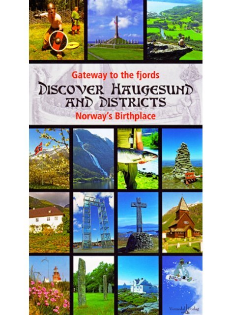
Gateway to the fjords<br />
Discover <strong>Haugesund</strong><br />
and districts<br />
Norways birthplace<br />
By Tor Inge <strong>Vormedal</strong><br />
2007
Table of contents<br />
Preface: Norway and Norwegians ............................................................... 6<br />
<strong>Haugesund</strong> ....................................................................................................................... 10<br />
Karmøy ................................................................................................................................ 44<br />
Tysvær .................................................................................................................................. 66<br />
Bokn ....................................................................................................................................... 76<br />
Vindafjord......................................................................................................................... 82<br />
Etne ........................................................................................................................................ 96<br />
Folgefonna Glacier .................................................................................................... 108<br />
Walking and Hiking .................................................................................................. 112<br />
Sauda .................................................................................................................................... 116<br />
Suldal .................................................................................................................................... 124<br />
Utsira..................................................................................................................................... 134<br />
Sveio ...................................................................................................................................... 140<br />
Bømlo ................................................................................................................................... 146<br />
The Triangle Link......................................................................................................... 156<br />
Stord - Fitjar .................................................................................................................... 158<br />
Kvinnherad ...................................................................................................................... 166<br />
Odda ...................................................................................................................................... 180<br />
Ullensvang ....................................................................................................................... 192<br />
All Roads Lead to <strong>Haugesund</strong> ......................................................................... 204<br />
Cycling Holiday ............................................................................................................ 210<br />
A Round Trip of Karmøy .............................................................................. 213<br />
Cycling in Sunnhordland .............................................................................. 217<br />
The Interior of <strong>Haugesund</strong>......................................................................... 221<br />
Round Trip by Car ...................................................................................................... 224<br />
Golf ......................................................................................................................................... 228<br />
Hunting, Fishing and Outdoor Life ............................................................. 232<br />
Winter and Snow ....................................................................................................... 246
Røvær<br />
0 1 km<br />
Ur<br />
Ulvøy<br />
Hillerøy<br />
Gitterøy<br />
10<br />
Bjørkevær<br />
<strong>Haugesund</strong><br />
<strong>Haugesund</strong> is the gateway to one of the most beautiful<br />
parts of Norway. Using this seaside town as your starting<br />
point, you can reach fjords and mountains, eternal<br />
snow, historical attractions and unique nature within<br />
no time.<br />
Kvalsvik<br />
Hagland<br />
Bergstøl<br />
Bleivik<br />
Førlandsvågen<br />
Årabrot<br />
Smedasundet<br />
Tornesvt.<br />
Hauge<br />
Hasseløy<br />
Vibrandsøy<br />
Risøy<br />
Karmsundet<br />
Støle<br />
Førland<br />
Førlandsvt.<br />
Tornes<br />
Haraldshaugen<br />
Krosshaugen<br />
Skeisvt.<br />
0 2 km<br />
Viksefjorden<br />
Bakkavt.<br />
FACTS:<br />
Inhabitants: 32 303<br />
Area: 72 km 2<br />
www.haugesund.kommune.no<br />
Vikse<br />
Saltveit<br />
Saltveitvt. Gåsavt.<br />
Arka<br />
Arkavt.<br />
<strong>Haugesund</strong><br />
Rossabø<br />
47<br />
Skogland<br />
Ramsdalen<br />
47<br />
Eivindsvt.<br />
Rotavt.<br />
Hemmingstad<br />
Kallandsvt.<br />
Krokavt.<br />
Steinsfjellet<br />
227 m<br />
Skåredalen<br />
E 134<br />
Ørpetveit<br />
Kalland<br />
Sandvt.<br />
Discover <strong>Haugesund</strong> and Districts - Norway’s Birthplace<br />
Klauv<br />
Skardstad<br />
Kvernavt.
Klauv<br />
kardstad<br />
vernavt.<br />
Stakkestadvt.<br />
<strong>Haugesund</strong> is located by the Karmsund strait, the old king’s road, where<br />
seafarers have sought a safe fairway and a secure harbour since the Viking<br />
Age. This safe fairway, also called “Nordvegen”, is the origin of the name<br />
Norway.<br />
A Town Built on Herring Bones<br />
From the beginning of the 1800s and 150 years onwards, the coast of western<br />
Norway was blessed with vast amounts of Norwegian spring spawning herring<br />
every spring. One of the places where the herring abounded was in the waters<br />
between Bømlo and Karmøy. A safe harbour and the proximity to these rich<br />
fi shing grounds, formed the basis of the establishment of <strong>Haugesund</strong> as a<br />
town.<br />
<strong>Haugesund</strong> was granted rights as a small seaport or ladested, i.e. city status, on<br />
August 26, 1854. Back then, <strong>Haugesund</strong> was no more than a small fi shing<br />
village , with as few as one thousand inhabitants. The extraordinary herring<br />
fi shery made <strong>Haugesund</strong> grow at great speed. Around the turn of the century,<br />
the small fi shing village had become a busy small town nearing 10 000 inhabitants.<br />
Today, <strong>Haugesund</strong> has more than 32 000 inhabitants and is the “capital”<br />
of a region with a population of approximately 150 000 inhabitants.<br />
Discover <strong>Haugesund</strong> and Districts - Norway’s Birthplace<br />
11
Feøy<br />
Sandhåland<br />
Jarsteinen<br />
44<br />
Helganes<br />
Åkrehamn<br />
Åkra<br />
Ferkingstad<br />
Kvalavåg<br />
Burmavegen<br />
Sandve<br />
Syre<br />
Visnes<br />
<strong>Haugesund</strong><br />
Lufthavn,<br />
Karmøy<br />
Sevlandsvik<br />
47<br />
Vea<br />
Holmavt.<br />
Ytraland<br />
Tistreivt.<br />
Geitungen fyr<br />
Karmsundet<br />
Vikjo<br />
Hauske<br />
518<br />
Mjåvt.<br />
Karmøy<br />
Torvastad<br />
Reheia<br />
Stiklevt.<br />
Hilleslandsvt.<br />
Hillesland<br />
Karmsundbroen<br />
Salhus<br />
Norheim<br />
Bø<br />
Avaldsnes<br />
Husøy<br />
Kopervik<br />
Stangaland<br />
K A R M Ø Y<br />
With its 38 000 inhabitants, Karmøy is the region’s<br />
largest municipality. Although the island<br />
is full of ancient monuments,<br />
Karmøy is a relatively new<br />
E 134<br />
municipality. Karmøy<br />
Municipality was es-<br />
Kolnes tablished in 1965 by a<br />
merger of the seven<br />
previous municipalities:<br />
Torvastad, Avaldsnes,<br />
<strong>Vormedal</strong><br />
Stangaland, Kopervik,<br />
Bukkøy<br />
Åkra, Skude nes and<br />
Tuastadvt.<br />
Tuastad Skudeneshavn.Karmøy<br />
Røyksund Municipality covers<br />
47<br />
an area of 225 km<br />
Høyevarde Fosen<br />
Bygnes<br />
2 ,<br />
of which 50 km2 is<br />
located on the mainland.<br />
Skudeneshavn<br />
511<br />
Hovdastad<br />
Til Kvitsøy/<br />
Mekjarvik<br />
Snorteland<br />
Karmsundet<br />
Blikshamn<br />
Våga<br />
Selen<br />
0<br />
Førdesfjorden<br />
Høvring<br />
3 km<br />
FACTS:<br />
Inhabitants: 38 349<br />
Area: 225 km 2<br />
www.karmoy.kommune.no<br />
Discover <strong>Haugesund</strong> and Districts - Norway’s Birthplace
Karmøy has both rural villages and towns. Karmøy’s three towns are<br />
Kopervik, Skudeneshavn and Åkrehamn. There are also twenty something<br />
built-up areas of various sizes. The largest one being Norheim, which is<br />
located at the mainland.<br />
Agriculture and fi shery are still important industries in Karmøy. But today, the<br />
manufacturing and service industry are more important with regard to employment.<br />
Norsk Hydro, Karmøy Fabrikker is the largest industrial work place<br />
with around 1500 employees. The municipality also has several companies<br />
within the mechanical industry aimed at shipping, fi shery and the oil industry.<br />
One of the country’s largest offshore shipping companies, Solstad Offshore<br />
ASA, is located in Skudeneshavn.<br />
The company have<br />
more than 40 vessels and 1000<br />
employees. The North Sea gas<br />
has also had a great impact on<br />
employment in Karmøy. While<br />
Gassco makes sure the gas<br />
from the North Sea is being<br />
distributed to Europe, Gasnor<br />
attends to the distribution of<br />
gas within Norway .<br />
Solstad Offshore<br />
Gassco:<br />
15 per cent of all gas used in Europe comes from Norway, and the main centre<br />
for the transportation of Norwegian gas to Europe, Gassco, is located at Bygnes<br />
in Karmøy. Gassco has 270 employees and controls the world’s largest offshore<br />
Discover <strong>Haugesund</strong> and Districts - Norway’s Birthplace<br />
From Skudeneshavn<br />
PHOTO: HEINE BIRKELAND<br />
45
Nesheim<br />
Dragavik<br />
Førresfjorden<br />
66<br />
Valhest<br />
Stakkestadvt.<br />
Førresfjorden<br />
Høie<br />
Hola<br />
Aksdalsvt.<br />
Tysvær<br />
To the east of <strong>Haugesund</strong> lies Tysvær Municipality,<br />
with its 9500 inhabitants and covering an area of 419<br />
km2 . In addition to its stunning scenery of smooth<br />
coastal rock and high mountains, Tysvær boasts a<br />
beautiful cultivated landscape of well-maintained<br />
farms, lined up one after another.<br />
E 39<br />
Våg<br />
Grinde<br />
Apeland<br />
Gismervik<br />
Fuglavt.<br />
Førlandsfjorden<br />
Slåttevik<br />
Sundfør<br />
Hodnafjellet<br />
E 134<br />
Aksdal<br />
E 39<br />
Grindafjorden<br />
Førland<br />
Tysværvåg<br />
Stakland<br />
Hegglifjell<br />
Storavt.<br />
Mosvatnet<br />
Storavt.<br />
E 39<br />
Susort<br />
Hesthammar<br />
Falkeid<br />
Kårstø Haugsneset<br />
Frekasundet<br />
FACTS:<br />
Inhabitants: 9 513<br />
Area: 419 km 2<br />
www.tysver.kommune.no<br />
Sagbakken<br />
Sandbekken<br />
Hervik<br />
Skjoldafjorden<br />
515 Erland<br />
Skjoldastraumen<br />
Steinsvik<br />
Slogvik<br />
Hervikfjorden<br />
513<br />
T Y S V Æ R<br />
Heskja<br />
Hundsnes<br />
Borgøy<br />
Stong<br />
Yrkje<br />
Sandvik<br />
Espevik<br />
Liarvåg<br />
Toftøy<br />
Lammanuten<br />
Discover <strong>Haugesund</strong> and District - Norway’s Birthplace<br />
Muslandsvåg<br />
0<br />
Yrkjefjorden<br />
Vassendvik<br />
515<br />
Nedstrandfjorden<br />
Lysevt<br />
Hin<br />
Tve
Yrkjefjorden<br />
assendvik<br />
5<br />
randfjorden<br />
Lysevt.<br />
Tveit<br />
Øvrabø<br />
Kvam<br />
Nessa<br />
Øverland<br />
The administrative centre of Tysvær is Aksdal, only 12 km<br />
from <strong>Haugesund</strong>. Here you will fi nd Tysværtunet, the<br />
municipality’s cultural centre, which has an indoor<br />
swimming pool, as well as a cinema and concert hall.<br />
Nedstrand With 260 operational farms, farming is still an impor-<br />
Holekleiv tant industry in the municipality. Around every tenth<br />
household in Tysvær carries on some form of agricul-<br />
Til Jelsa tural activity. The main place of employment in the<br />
municipality is, however, Statoil’s gas processing<br />
Til Hanasand complex at Kårstø. This is Europe’s largest gas terminal,<br />
with 1000 employees.<br />
5 km<br />
Kårstø:<br />
Though Tysvær has numerous sights in the form of stunning scenery and historical<br />
landmarks, it is the gas processing plant at Kårstø that puts the municipality on<br />
the map. Gassco is the operator of Kårstø, while Statoil is the technical services<br />
provider. Tysvær hit the jackpot when, in 1981, the Norwegian Parliament<br />
decided that Statoil could land gas from the Statfjord oil fi eld at Kårstø. From<br />
being a poor rural municipality experiencing major depopulation, Tysvær became<br />
a wealthy municipality with an infl ux of new residents. Thanks to the<br />
gas terminal at Kårstø, the municipality presently receives property tax from<br />
the plant as well as income tax from all those working at the terminal.<br />
Of Tysvær’s total budget of about NOK 500 million, NOK 100 million is<br />
Hinderåvåg<br />
Discover <strong>Haugesund</strong> and Districts - Norway’s Birthplace<br />
Hodnafjellet Mountain<br />
67
Grønestadvågen<br />
Trosnavåg<br />
76<br />
Breivik<br />
Gunnarstadvt.<br />
Grønestadvt.<br />
Sunnalandstraumen<br />
Klepp<br />
Bokn<br />
Bokn is a small island-municipality in the middle of the<br />
shipping lane at the southern end of the Karmsund<br />
strait. With its 800 inhabitants and a surface area<br />
covering 47 km 2 , Bokn is one of the smallest municipalities<br />
in the country.<br />
Vestre Bokn<br />
Kjeøy<br />
Boknafjellet<br />
Ulvånå<br />
Hognalandsvt.<br />
Alvestad<br />
Vatnaland<br />
Vatnalandsvt.<br />
Hognåsen<br />
Arsvt.<br />
Are<br />
Boknafjorden<br />
Arsvågen<br />
Ognahabn<br />
Ognøy<br />
Ognasundet<br />
Nydal<br />
Kro<br />
Øvrabøneset<br />
B O K N<br />
Føresvik<br />
Boknabergvt.<br />
Alvestadkroken<br />
Laupland<br />
E 39<br />
E 39<br />
Ognakalven<br />
Austre Bokn<br />
Tåganes<br />
Boknasundet<br />
Til Mortavika<br />
0<br />
Våga<br />
Nipa<br />
Nore<br />
Vågaholmen<br />
200 m<br />
FACTS:<br />
Inhabitants: 793<br />
Area: 47 km 2<br />
www.bokn.kommune.no<br />
Discover <strong>Haugesund</strong> and District - Norway’s Birthplace<br />
Nautøy
Western Bokn.<br />
Bokn consists of three islands: Western and Eastern Bokn and Ognøy. Its<br />
administrative centre is located on Western Bokn, which is the largest of<br />
the three islands, and where most of the inhabitants live.<br />
Bokn was connected to the mainland in 1991 when the new coastal highway,<br />
E-39, was built. The ferry service over Boknafjorden used to cross from<br />
Skudeneshavn to Tungesnes, but today the ferries go between Arsvågen and<br />
Mortavika. Arsvågen is located at the southernmost tip of Western Bokn. If<br />
you’re going from Stavanger to <strong>Haugesund</strong> or Bergen by car, you’ll have to<br />
cross the three islands at Bokn. But Bokn has more to offer than nice freeways.<br />
In stead of rushing across the islands at high speed, you should take your time<br />
and make a few longer or shorter breaks.<br />
Discover <strong>Haugesund</strong> and Districts - Norway’s Birthplace<br />
77
E 134<br />
82<br />
Ålfjorden<br />
Årvikhamn<br />
Årvik<br />
Ålfjorden<br />
Isvik<br />
Kvamshamn<br />
Haraldseidvågen<br />
Vindafjord<br />
Vindafjord got new borders in 2006 when it merged<br />
with the neighbouring municipality Ølen. In the debate<br />
over the name of the new municipality, Vindafjord drew<br />
the longest straw. The new Vindafjord Municipality<br />
stretches out from Sunnhordland in the north to Ryfylke<br />
in the south. With a surface area of 641 km 2 , Vindafjord<br />
is the fourth largest municipality in Rogaland.<br />
Bjoa<br />
Skredfjellet<br />
Langavt.<br />
Vikebygd<br />
Bjordal<br />
Haraldseid<br />
Gardavika<br />
Skjold<br />
Utbjoa<br />
Dalselva<br />
Vikefjellet<br />
513<br />
Til Sydnes/<br />
Halsnøy<br />
Bjoavatnet<br />
Innbjoa<br />
Eikås<br />
Haugsfjell<br />
Eikeland Aurdal<br />
Velde<br />
Knapphus<br />
Vatsvt.<br />
Solheim 46<br />
Nesheim<br />
Otertong<br />
Vats<br />
Åmsosen<br />
Stråtveit<br />
Vatsfjorden<br />
Raunes<br />
Ølensvåg<br />
Viland<br />
Romsaøyene<br />
543<br />
Ilsvåg<br />
Gjerdesdalsvt.<br />
Dreganes<br />
Ølensfjorden 05 km<br />
Ølen<br />
V I N D A F J O R D<br />
Skjoldafjorden<br />
FACTS:<br />
Inhabitants: 8 111<br />
Area: 641 km 2<br />
www.vindafjord.kommune.no<br />
Eide<br />
Stokkadalsvt.<br />
Yrkjefjorden<br />
Sandeidfjorden<br />
Hovåsen<br />
Oselva<br />
514<br />
Øklandsvt.<br />
Stuhaug<br />
Sandeid<br />
Rødneelva<br />
Vikedal<br />
Hogganvik<br />
Imsland<br />
Vindafjorden<br />
Discover <strong>Haugesund</strong> and Districts - Norway’s Birthplace<br />
46<br />
E 134<br />
Låkafossen<br />
Mo<br />
Vikedalselva<br />
Fjellgardsvt. Stølsm<br />
Haugland<br />
Ølmedalsvt.<br />
Horganut<br />
Aksland
dsvt. Stølsmarka<br />
Horganuten<br />
Aksland<br />
46<br />
View of Ølensvåg<br />
Vindafjord is the largest agricultural municipality in the <strong>Haugesund</strong><br />
district, with nearly 500 operational farms. The municipality’s<br />
major attractions are beautiful nature and a well-kept cultural<br />
landscape.<br />
Ølen has always been an important junction in the district with a regular<br />
ferry service to Bergen. Today, it’s the European route (E-134) between<br />
<strong>Haugesund</strong> and Oslo that makes Ølen an important junction. This is<br />
why Ølen was chosen to be the municipality’s new administrative centre.<br />
Ølen also has a motel, a bank and a shopping centre, as well as primary,<br />
secondary and upper secondary schools.<br />
Ropeid<br />
T Today, the new Vindafjord Municipality has a little over 8000 inhabitants.<br />
As in most other rural municipalities, it has a scattered population.<br />
The nine rural communities in Vindafjord are: Vikedal, Imsland,<br />
Sandeid, Vats, Skjold, Ølen, Ølensvåg, Bjoa and Vikebygd. Several of<br />
these villages used to be independent municipalities.<br />
Rønnevik<br />
Although Vindafjord is a major agricultural municipality, it also has a fair<br />
amount of industry. Large parts of Vindafjord’s industry are centred in Ølen<br />
and Ølensvåg. Here you’ll fi nd both a slaughterhouse, a ship yard and a computer<br />
company. Fatland is one of the country’s largest privately owned slaughterhouses.<br />
Of a total of 500 employees in the Fatland group, 200 work in Ølen.<br />
Discover <strong>Haugesund</strong> and Districts - Norway’s Birthplace<br />
PHOTO: PEDER LUNDEGÅRD<br />
83
Sandvik<br />
Børkjenes<br />
96<br />
Leknes<br />
Taraldsøy<br />
Skånevik<br />
Ebna<br />
Osnes<br />
Bjørgjo<br />
E 134<br />
Sørstranda<br />
0 5 km<br />
Etne<br />
In addition to having one of the world’s<br />
most majestic and beautiful waterfalls,<br />
Etne can offer wild, beautiful and varied<br />
nature. Here, you’ll fi nd fjords, waterfalls,<br />
eternal snow and vital rural communities.<br />
FACTS:<br />
Inhabitants: 3 858<br />
Area: 708 km 2<br />
www.etne.kommune.no<br />
Til Matre/<br />
Utåker<br />
Tungesvik<br />
48<br />
Etne Grønstad<br />
Stødle<br />
Håfoss<br />
Kyrping<br />
Håland<br />
Stordalsvatnet<br />
Kvammen<br />
Litledalsvatnet<br />
Skarstøl<br />
Rus Krokavatnet<br />
Ilsvatnet<br />
Forevatn Bjønndalen<br />
Frette<br />
Flåte<br />
Åkrafjorden<br />
Teigland<br />
Eikemo<br />
Tysse<br />
E T N E<br />
Markhus<br />
Discover <strong>Haugesund</strong> and Districts - Norway’s Birthplace<br />
Folgefonna<br />
Sandvikevatnet<br />
Mosnes<br />
Langfoss<br />
Fjæra<br />
Vaulavatnet<br />
Rulle<br />
Rulle
olgefonna<br />
atnet<br />
æra<br />
vatnet<br />
Rullestad<br />
E 134<br />
Rullestadvatnet<br />
Skromme<br />
The statue of King Magnus Erlingsson outside Etne Courthouse.<br />
Etne is located 60 kilometres from <strong>Haugesund</strong> and is surrounded by the<br />
municipalities Odda, Sauda, Suldal, Vindafjord and Kvinnherad. This scenic<br />
municipality covers a surface area of as much as 708 km 2 . Half of the<br />
municipality’s 3900 inhabitants live in the built-up areas Etne sjøen and<br />
Skånevik. Etnesjøen is the municipality’s administrative centre. In the<br />
north-east, Etne borders Folgefonna National Park and the Folgefonna<br />
glacier. (See separate chapter on Folgefonna on page 108-111.)<br />
The rich soil has formed the basis for Etne’s growth and prosperity for generations.<br />
Archaeological fi ndings suggest that there have been settlements at Etnesjøen<br />
for thousands of years. Farming is still an important industry in Etne, but<br />
not the most important one. Today, there are less than 200 operational farms in<br />
Etne, which means that one in seven households is involved in farming. Today,<br />
trade, tourism and the public sector are the municipality’s major employers.<br />
Etne sjøen has a complete offer of all public services for the community’s inhabitants,<br />
such as nursing home, day-care centre, primary school and lower and<br />
upper secondary school. There is also a wide selection of shops, sports installations,<br />
a marina and a culture centre with cinema and concert hall. There is even an<br />
authentic American saloon on “the prairie” of Etne; the Old River Saloon, where<br />
they strike up the dance music every weekend.<br />
Discover <strong>Haugesund</strong> and Districts - Norway’s Birthplace<br />
97
Hustveitsåta<br />
1188<br />
116<br />
Nordstøldalen<br />
Saudasjøen<br />
Svandal<br />
Svandalsfossen<br />
Honganvik<br />
Hustveit<br />
Sauda<br />
At the innermost end of the Sauda Fjord lies the industrial<br />
municipality Sauda with its 4700 inhabitants. The municipality<br />
is surrounded by high mountains and covers a<br />
surface area of 514 km 2 .<br />
FACTS:<br />
Inhabitants: 4 732<br />
Area: 514 km 2<br />
www.sauda.kommune.no<br />
520<br />
Saudafjorden<br />
Buer<br />
Åbøbyen<br />
Ramsnes<br />
Vanvik<br />
Maldal<br />
Storelva<br />
Reinsnuten<br />
1169<br />
Slettedalen<br />
Indrejord<br />
S A U D A<br />
Sauda<br />
Skorvenuten<br />
1124<br />
Slettedalsvt.<br />
Minnehaugen<br />
Hellandsbygd<br />
Storli<br />
Storlivt.<br />
Allmannajuvet<br />
0 5 km<br />
Kyrkjenuten<br />
1602<br />
N. Berdalsvt.<br />
(Vinterstengt)<br />
520<br />
Ø. Berdalsvt.<br />
Førstadvt.<br />
Skaulen<br />
1540<br />
Discover <strong>Haugesund</strong> and Districts - Norway’s Birthplace<br />
Breiborg<br />
Holmavt.<br />
Ø. Sand<br />
N. Sa<br />
Svartevt.
Svartevt.<br />
rg<br />
Ø. Sandvt.<br />
N. Sandvt.<br />
It was the vast water resources that were the foundation for Sauda as<br />
an industrial community. Before Aktieselskapet Saudefaldene tamed the<br />
waterfalls, Sauda was a poor farming community with only a few hundred<br />
inhabitants.<br />
In 1913, they started to pipe the waterfalls. Access to vast amounts of cheap<br />
energy and an ice-free harbour was the reason why the American company<br />
Electric Furnace Products (EFP) built a ferroalloy plant in Sauda. In the golden<br />
era from the mid 50s to the mid 60s, the factory had 1300 employees. Since<br />
the smelter started producing manganese in 1923, it has had several owners. In<br />
1982, Elkem bought the company and named it Sauda Smelting Plant. Elkem<br />
ran the plant until 1999 when they sold it to the French industrial company<br />
Eramet. Today, more manganese than ever is being produced in Sauda, but the<br />
number of employees has been substantially reduced. Today, around 400 people<br />
work in the plant itself, and 200 of these are employed by Eramet. Just like so<br />
many other industrial communities, also Sauda has been forced to reorganise.<br />
Today, Sauda has several smaller industrial companies and a constantly growing<br />
tourist industry.<br />
Discover <strong>Haugesund</strong> and Districts - Norway’s Birthplace<br />
117
Til Nedstrand<br />
Jelsafjorden<br />
124<br />
Rosseid<br />
Kjølvik<br />
Hebnes<br />
Foldøy<br />
Til Hanasand<br />
Suldal<br />
Suldal is located south-east of <strong>Haugesund</strong> and is a part<br />
of the region Ryfylke in Rogaland County. This widespread<br />
municipality is like a small piece of Norway, with<br />
sheltered fjord landscapes, deep forests and high<br />
mountains.<br />
Finnvik<br />
Marvik<br />
Israelsneset<br />
517<br />
Jelsa<br />
FACTS:<br />
Inhabitants: 3 874<br />
Area: 1727 km 2<br />
www.suldal.kommune.no<br />
Ropeid<br />
46<br />
Sandsfjorden<br />
520<br />
Saudafjorden<br />
Sand<br />
Lovraeid<br />
Tysse<br />
Vanvik<br />
Mo<br />
Hålandsdalen<br />
Erfjord Hålandstunet<br />
Foreneset<br />
Erøy<br />
Bogsund<br />
13<br />
Suldalseidet<br />
Mosvt.<br />
Tengesdal<br />
Hylsfjorden<br />
Sul dals låge n<br />
Gullingen<br />
0 5 km<br />
Skaulen<br />
1540<br />
Våge<br />
Hylen<br />
Hylsskaret<br />
Suldalsporten Kvilldal<br />
Kolbeinstveit<br />
Suldalsosen<br />
Lindum<br />
Ritland<br />
Ulladalen<br />
Sandsa<br />
Sandsavt.<br />
Discover <strong>Haugesund</strong> and Districts - Norway’s Birthplace<br />
Bratlan<br />
Suldalsvt.<br />
Nesf<br />
Røynevarden<br />
S U L D<br />
13<br />
Stranddalen
Bratlandsdalen<br />
nevarden<br />
Suldalsvt.<br />
Nesflaten<br />
13<br />
randdalen<br />
Bråtveit<br />
Roaldkvam<br />
Mostøl<br />
L D A L<br />
bom<br />
Finnabuvt.<br />
Bleskestad<br />
Sandvt.<br />
bom<br />
Covering a surface area of 1727 km2 Bleskestadmoen<br />
, Suldal is<br />
the largest municipality in Rogaland. With regard<br />
to the number of inhabitants, however, the municipality<br />
is small. Suldal has fewer than 4000 inhabitants,<br />
of which around 1200 live in the municipal centre of<br />
Sand. Farming is the main industry in Suldal and this is<br />
why the municipality has such a scattered population.<br />
Water Power:<br />
Suldal is a power-based municipality, which means that it has<br />
exploited its vast water resources in the production of electric<br />
Blåsjø<br />
power. Today, the municipality earns a lot of money from the<br />
power plants. From 1963 to 1987, there were two large power<br />
development projects in the municipality. First Røldal-Suldal,<br />
and then Ulla-Førre. The latter is the largest development project for<br />
hydroelectric power in Northern Europe. The largest reservoir in the Ulla-<br />
Førre project is called Blåsjø and contains three billion cubic metres of water.<br />
The Blåsjø reservoir has a long-time storage capacity, which means it will<br />
contain a water reserve for as much as three years even with no precipitation.<br />
The reservoir consists of 11 dams, and the artifi cial lake covers a surface area<br />
Discover <strong>Haugesund</strong> and Districts - Norway’s Birthplace<br />
Sand.<br />
125
Helganes<br />
134<br />
0 500 m<br />
Utsira<br />
West of Karmøy lies Utsira. Measuring only 6 km 2 and<br />
home to 214 residents, Utsira is Norway’s smallest<br />
municipality by population and smallest but one in size.<br />
Vestramarka<br />
Spannanes<br />
Kvalvik<br />
Nordevågen<br />
Skare<br />
Klovning<br />
Nordvik<br />
U T S I R A<br />
Hovland<br />
FACTS:<br />
Inhabitants: 214<br />
Area: 6 km 2<br />
www.utsira.kommune.no<br />
Sørevågen<br />
Til <strong>Haugesund</strong><br />
Austramarka<br />
Måbjør<br />
Austrheim<br />
Til <strong>Haugesund</strong><br />
Discover <strong>Haugesund</strong> and Districts - Norway’s Birthplace
Discover <strong>Haugesund</strong> and Districts - Norway’s Birthplace<br />
Sørevågen<br />
Utsira is an exotic destination that should be included on your visit to<br />
the <strong>Haugesund</strong> district. In addition to beautiful, but exposed nature, this<br />
little island can offer sights such as Norway’s most unique birdlife and<br />
the world’s fi rst wind turbine and hydrogen power plant.<br />
A ferry will take you to Utsira three times a day. The crossing takes an hour<br />
and ten minutes, and the ferry leaves from Garpeskjærskaien on Risøy, in<br />
<strong>Haugesund</strong>. If you have a bicycle, we recommend that you bring it along, as<br />
the roads on Utsira are perfect for biking.<br />
For years, combined fi shing and farming have been the principle industries of<br />
the people of Utsira. Nowadays, the primary employer on the island is the<br />
municipality, although there are still those who make a living off the sea. Like<br />
most other municipalities, Utsira focuses on tourism. As a result, new types of<br />
accommodation and eateries have emerged over the past few years.<br />
Nordevågen<br />
135
Sletta<br />
Lyngholmen<br />
Ryvarden fyr<br />
Mølstrevåg<br />
Eltravåg<br />
541<br />
Vikse<br />
Viksefjorden<br />
Ekrene<br />
Sveio<br />
FACTS:<br />
Inhabitants: 4 764<br />
Area: 246 km 2<br />
www.sveio.kommune.no<br />
140<br />
North of <strong>Haugesund</strong> lies Sveio Municipality. With<br />
its 4700 inhabitants and a surface area covering<br />
246 km 2 , Sveio is one of the smallest municipalities<br />
in the Hauge sund district.<br />
Til Langevåg<br />
Hovda<br />
Tjernagel<br />
Buavåg<br />
47<br />
Auklandshamn<br />
Storavatnet<br />
Sveio<br />
Tveit<br />
Kinn<br />
Færås<br />
Slettene<br />
Bømlafjorden<br />
Emberlandsnipen<br />
271 moh<br />
S V E I O<br />
Nordskog<br />
Vigdarvatnet<br />
Lindøy<br />
Hinderlid<br />
Bjelland<br />
Eilerås<br />
Førdespollen<br />
Vestvik<br />
Haukås<br />
Bømlafjordtunnelen<br />
Straumøy<br />
Fagerland<br />
Langavatnet<br />
E 39<br />
0 5 km<br />
Leirvågen<br />
Rød<br />
Fjon<br />
Liereid<br />
Førde<br />
Liervassdraget<br />
Våga<br />
Kvalvåg<br />
Valestrand<br />
Einstadbøvoll<br />
Valevåg<br />
E 39<br />
Flatnes<br />
Hopsfjellet<br />
333 moh<br />
Tveit<br />
Tittelsnes<br />
Haugsbu<br />
Staupe<br />
Børshovda<br />
186 moh<br />
Erve<br />
Oa<br />
Trollavassnipen<br />
432 moh<br />
Håvardsholm<br />
Dreng<br />
277 moh<br />
Røykenes<br />
Selåsvika<br />
Ålfjorden<br />
Discover <strong>Haugesund</strong> and Districts - Norway’s Birthplace<br />
Bjørgo<br />
Ålfjorden<br />
Bjoafjorden
fjorden<br />
Discover <strong>Haugesund</strong> and Districts - Norway’s Birthplace<br />
Ryvarden Lighthouse<br />
The main road on the west coast of Norway, the coastal trunk road E-39,<br />
cuts through the beautiful and varied landscape in Sveio. If you don’t<br />
step too hard on the throttle, you’ll be able to enjoy everything from<br />
well-kept smallholdings to fjords and mountains and fl at heaths, all<br />
from the road.<br />
And let’s not forget all the small fi shing lakes. Ten per cent of the municipality’s<br />
surface area is covered by large and small freshwater lakes. More precisely,<br />
Sveio has 282 lakes, of which Vigdarvatnet is the largest one. In most of the<br />
lakes you’re permitted to swim, fi sh and paddle.<br />
Today’s municipality was established in 1965 after a merger of the municipalities<br />
Sveio, Vikebygd and Valestrand. Sveio is the southernmost municipality in<br />
Hordaland County and is shaped like a peninsula surrounded by Sletta and<br />
Bømlafjorden to the west and Ålfjorden to the east. On the mainland, Sveio<br />
borders both Tysvær and <strong>Haugesund</strong>. Sveio has a scattered population, but the<br />
majority lives in and around the two villages Sveio and Førde. The administrative<br />
centre is located in the village of Sveio.<br />
Agriculture combined with coastal fi shery used to be a common source of income<br />
in Sveio. Agriculture is still an important industry in the municipality, but today<br />
there are only 130 operational farms left. The majority of the working population<br />
works outside the municipality, primarily in <strong>Haugesund</strong>.<br />
141
Brandasund<br />
Gisøy<br />
Rogøy<br />
Goddo<br />
Skotningen<br />
Meling<br />
FACTS:<br />
Inhabitants: 10 892<br />
Area: 247 km 2<br />
www.bomlo.kommune.no<br />
146<br />
Bømlo<br />
Erevik<br />
Økland<br />
Osen<br />
Gissøy<br />
Bømlo Municipality is an island community<br />
in the <strong>Haugesund</strong> district, consisting of<br />
more than one thousand small and<br />
large islands. This is a paradise<br />
for those who like fi shing<br />
and boating.<br />
Rolvsnes<br />
Hiskosen<br />
Svortland<br />
Lykling<br />
541<br />
Sagvt.<br />
Berge<br />
Selsvt.<br />
542<br />
Bømlo<br />
Eidesvik Langevåg<br />
Espevær<br />
Kalavåg<br />
Rubbestadneset<br />
Andal<br />
Foldrøyhamn<br />
B Ø M L O<br />
Midtøy<br />
Stongarvåg<br />
Sakseid<br />
Selvåg<br />
Hjartnes<br />
Kulleseid<br />
Børøyvik<br />
Barane<br />
0<br />
Til Buavåg<br />
Foldrøy<br />
Børøyfjorden<br />
Siggjo<br />
471 m<br />
Bømlafjorden<br />
Rutsøy<br />
541<br />
Stokksund<br />
Håvik<br />
Røyksund<br />
Tøtland<br />
5 km<br />
Spissøy<br />
Moster<br />
Mosterhamn<br />
Discover <strong>Haugesund</strong> and Districts - Norway’s Birthplace
With 11 000 inhabitants and a surface area of 247 km 2 , Bømlo is a typical<br />
mid-sized rural municipality. The inhabitants are scattered around the<br />
six built-up areas Rubbestadneset, Finnås, Mosterhamn, Langevåg and<br />
Svortland (Bremnes). The municipality’s administrative centre is located<br />
at Svortland, which is the largest of these six built-up areas.<br />
Surrounded by ocean on all sides, it goes without saying that maritime industries<br />
infl uence the municipality’s working life. Bømlo has shipping industry, a fi shing<br />
fl eet, shipping companies and fi sh farming. The two major work places at<br />
Bømlo is the offshore shipping company Eidesvik A/S and Wärtsilä. Eidesvik<br />
A/S is a stock-listed shipping company with around 600 employees and a fl eet<br />
consisting of 21 modern offshore vessels. The ship engine manufacturer<br />
Wärtsilä produces propellers and gear systems for large vessels and has more<br />
than 500 employees at Bømlo. Aquaculture and fi sh farming is also a big<br />
industry . When you travel around Bømlo, you will see fi sh farming facilities<br />
for grow-out fi sh, juvenile fi sh and shellfi sh. Bømlo also has some of the<br />
country’s<br />
Discover <strong>Haugesund</strong> and Districts - Norway’s Birthplace<br />
Moster Church<br />
largest fi sh harvesting plants. Every day 35 000 salmon is being<br />
harvested and exported from Bømlo. That is the equivalent to three per cent of<br />
the entire world production.<br />
There are several ways to get to the island paradise Bømlo. For those who<br />
would like a lovely boat trip through the beautiful skerries, there is an express<br />
boat with daily departures from <strong>Haugesund</strong> to Mosterhamn. You can also arrive<br />
147
Tranøy<br />
Ivarsøy<br />
Ålforo<br />
Stord - Fitjar<br />
The island of Stord is located between Bergen and<br />
<strong>Haugesund</strong>. On the island itself, there are two municipalities,<br />
Fitjar and Stord. The two municipalities are<br />
almost the same size, with a surface area of 145 and<br />
144 km 2 , respectively. As regards the population, however,<br />
Stord is the bigger one with its 16 700 inhabitants,<br />
while Fitjar has 2 900.<br />
Fodno<br />
Årskog<br />
Storavatn<br />
Koløyholmen<br />
Dåfjordeid<br />
FACTS:<br />
Inhabitants Stord: 16 850<br />
Inhabitants Fitjar: 2 897<br />
Area: 145 and 144 km 2<br />
www.stord.kommune.no<br />
www.fi tjar.kommune.no<br />
158<br />
Fitjar<br />
Rydland<br />
Sandvikvåg<br />
Sørstokken<br />
Sagvåg<br />
Digernes<br />
Midtfjell<br />
798 m<br />
F I T J A R<br />
545<br />
Til Halhjem<br />
E 39<br />
Vistvik<br />
Kattanakken<br />
724 m<br />
Leirvik<br />
Skjersholmane<br />
Jektevik<br />
S T O R D<br />
Mennene<br />
500 m<br />
0<br />
Melhammer<br />
E 39<br />
Sponavikjo<br />
Eskeland<br />
Breivikjo<br />
Til Ranavik/Sunde<br />
5 km<br />
Til Hodnanes<br />
Discover <strong>Haugesund</strong> and Districts - Norway’s Birthplace<br />
Huglo<br />
Haukanes
o<br />
Haukanes<br />
Discover <strong>Haugesund</strong> and Districts - Norway’s Birthplace<br />
The Stord Door, sculpture made by Sissel Tolaas in 2006.<br />
Stord Municipality has had city status since 1997, and is today the centre<br />
of Sunnhordland. The “capital” of Stord is called Leirvik. Around 10 000<br />
of the inhabitants live in Leirvik, while 5 000 live around the densely<br />
populated area Sagvåg.<br />
Although the manufacturing industry has long traditions at Stord, it was agriculture<br />
that used to be the municipality’s main industry up until the late 1940s.<br />
What is today the cornerstone company at Stord, Aker Kværner Stord, was<br />
established in 1919 as a herring oil factory. In 1930, the factory went over to<br />
the mechanical industry, and from1945, they started building ships. In the<br />
159
Eidsvik<br />
Til Skjersholmane<br />
Klosterfjorden<br />
Til Utbjoa/<br />
Lykjelsøy<br />
Fjellberg<br />
Kolsøy<br />
Fjellbergøy<br />
Borgundøy<br />
Bjoafjorden<br />
Husnes<br />
Sunde<br />
544<br />
Sæbøvik<br />
Sydnes<br />
Kvinnherad<br />
Kvinnherad lies at the entrance to the Hardanger Fjord<br />
and has some of the most beautiful fjord landscapes<br />
in western Norway, with wild waterfalls, narrow fjords,<br />
steep mountains and eternal snow.<br />
FACTS:<br />
Inhabitants: 13 032<br />
Area: 1 137 km 2<br />
www.kvinnherad.kommune.no<br />
166<br />
Halsnøy<br />
Olve<br />
Onarheimsfjorden<br />
Høylandssundet<br />
Herøysundet<br />
Valen<br />
Skåneviksfjorden<br />
49<br />
48<br />
Gjermundshamn<br />
Mjelkhaug<br />
986 m<br />
Hatlestrand<br />
Snilstveitøy<br />
Uskedal<br />
Englefjell<br />
1200 m<br />
Utåker<br />
551<br />
Ulvanåsa<br />
1247 m<br />
Til Skånevik<br />
0<br />
48<br />
49<br />
Hardangerfjorden<br />
Matrefjorden<br />
Matre<br />
Varaldsøy<br />
Varaldsøy<br />
Løfallstrand<br />
Rosendal<br />
Dimmelsvik<br />
Indre Matre<br />
Varden<br />
600 m<br />
Slettefjell<br />
784 m<br />
Åkra<br />
Sild<br />
551<br />
Sildafjorden<br />
Ænes<br />
Melderskinn<br />
1424 m<br />
Malmangernuten<br />
889 m<br />
Rustefjell<br />
1099 m<br />
Maurangerfjorden<br />
Ænesdalen<br />
K V I N N H E R A D<br />
5 km<br />
Discover <strong>Haugesund</strong> and Districts - Norway’s Birthplace<br />
Gjerde<br />
Sundal<br />
FOLGEFONNA<br />
Folg<br />
Fonnan<br />
1454 m
Gjerde<br />
undal<br />
ONNA<br />
Folgefonntunnelen<br />
Fonnanuten<br />
1454 m<br />
Discover <strong>Haugesund</strong> and Districts - Norway’s Birthplace<br />
The Barony of Rosendal<br />
Covering an area of 1137 km 2 , Kvinnherad is one of the region’s biggest<br />
municipalities. Kvinnherad has a scattered population structure, and the<br />
approximately 13 000 inhabitants live in several smaller villages and rural<br />
communities. The largest rural community in Kvinnherad is Husnes with<br />
its 2500 inhabitants.<br />
Rosendal:<br />
Both geographically and as a municipal centre, Rosendal is the centre of Kvinnherad.<br />
Rosendal also gets the focus of attention when it comes to tourism.<br />
Although Kvinnherad has several beautiful rural communities and villages,<br />
none of them can really compare to Rosendal’s charm and attractions. In and<br />
around the village of Rosendal live just over 1000 inhabitants.<br />
The Barony Rosendal:<br />
The Barony Rosendal is not only the biggest tourist attraction in Kvinnherad.<br />
As one of the smallest castles in Scandinavia, the Barony is also one of the<br />
most well-known tourist attractions in Norway. The barony’s history dates<br />
back to 1650, when the Danish nobleman Ludwig Rosenkrantz came to Bergen<br />
as representative for the Danish king. In a ball at the fortress of Bergenhus in<br />
Bergen, he met Karen Mowatt, sole heiress to the country’s biggest fortune at<br />
the time. Her father owned more than 500 farms all over western Norway.<br />
When they married in 1658, they were given the farm Hatteberg in Rosendal<br />
as a wedding present. A few years after the wedding, Ludwig Rosenkrantz<br />
167
FOLGEFONNA<br />
180<br />
Folgefonntunnelen<br />
Buer<br />
0<br />
Sandvin<br />
Sørfjorden<br />
Sandvinvatnet<br />
Odda<br />
Odda is one of Norway’s most renowned industrial<br />
towns, surrounded by high mountains and stunning<br />
nature. The municipality is located at the innermost<br />
end of the Hardanger Fjord and covers a surface area of<br />
as much as 1648 km 2 . The majority of the 7200 inhabitants<br />
live in and around the town of Odda.<br />
Tyssedal<br />
13<br />
Odda<br />
Brekke<br />
Skarsmo Skare<br />
Utsikten<br />
E 134<br />
5 km<br />
Seljestad<br />
Reinsnos<br />
Seljestadjuvet<br />
Ekkjeskar<br />
520<br />
Bersåvatnet<br />
Ringedalsvatnet<br />
Reinsnosvatnet<br />
13<br />
Langavatnet<br />
Røldal<br />
Røldalsvatnet<br />
Botna<br />
Blånut<br />
1526<br />
FACTS:<br />
Inhabitants: 7 154<br />
Area: 1648 km 2<br />
www.odda.kommune.no<br />
Bretavatnet<br />
O D D A<br />
Bjørnanuten<br />
1613<br />
Valldalsvatnet<br />
Austmannali<br />
Votna<br />
Breifonn<br />
Solfonn<br />
Valldalseter<br />
Midtleger<br />
Holmavatnet<br />
E 134<br />
Store Nupsfonn<br />
1693<br />
Discover <strong>Haugesund</strong> and District - Norway’s Birthplace<br />
Hellevatnet
net<br />
Odda has long traditions for tourism. More than one hundred years ago,<br />
Odda was one of Europe’s most important tourist destinations.<br />
Princes, emperors, aristocrats and the wealthy all came to Odda to see<br />
the magnifi cent nature with its waterfalls, fjords and glaciers. At the<br />
most, Odda was visited by around eighty cruise ships every year. In addition<br />
came the armada of German warships that escorted William II of Germany on<br />
his visits to Odda and the Hardanger Fjord every summer. Back then, Odda<br />
was a small village with a few hundred inhabitants making a living of farming<br />
and tourism. In the late 1800s, the small village had as many as ten hotels,<br />
receiving thousands of tourists from May to August. But it wasn’t only the<br />
tourists that were attracted to the Hardanger Fjord and the impressive waterfalls.<br />
Around the turn of the century, Odda was being explored by engineers<br />
and industrialists from abroad. With its access to large waterfalls and excellent<br />
harbours, Odda was perfect for industry.<br />
A Model Municipality:<br />
The fi rst power station was<br />
built in the neighbouring village<br />
Tyssedal, and was completed<br />
in 1908. In very short<br />
time, Odda went from being a<br />
small, rural romantic village<br />
to a hectic industrial town<br />
with 4000-5000 inhabitants.<br />
The new plants were built<br />
with no consideration of<br />
Discover <strong>Haugesund</strong> and Districts - Norway’s Birthplace<br />
181
Hardangerfjorden<br />
550<br />
Alsåker<br />
Sørfjorden<br />
Utne<br />
550<br />
Aga<br />
Syreflot<br />
Åkre<br />
Bleie Nå<br />
Reisæter<br />
Lindvik<br />
FOLGEFONNA<br />
Måge<br />
Til Kvanndal<br />
Hesthamar<br />
Jåstad<br />
Velure<br />
Espe<br />
Fresvik<br />
In the heart of Hardanger lies the fruit-farming municipality<br />
Ullensvang. The small and steep fruit farms in<br />
Ullensvang have around 600 000 fruit trees. The fruit<br />
blossom in May is a marvellous sight which has made<br />
Ullensvang famous both in Norway and abroad.<br />
0<br />
Utnefjorden<br />
Børve<br />
Sekse<br />
Hovland<br />
Naustflot<br />
Trones<br />
Langasete<br />
Hauso<br />
13<br />
5 km<br />
Eidfjorden<br />
Kinsarvik<br />
Lofthus<br />
Opedal<br />
Ullensvang<br />
Frøynes<br />
Opesjovt.<br />
Sandstå<br />
Ystanes<br />
Røte<br />
Store<br />
Vendelvt.<br />
FACTS:<br />
Inhabitants: 3 416<br />
Area: 1 393 km 2<br />
www.ullensvang.herad.no<br />
192<br />
Ullensvang<br />
Hus<br />
13<br />
Ringøy<br />
Vassdalsnutane<br />
Stavalivt.<br />
Bu<br />
Store Flåtten<br />
Illakleivløkene<br />
Veivt.<br />
Sovarenuten<br />
U L L E N S V A N G<br />
Øvre<br />
Tyssevt.<br />
HARDANGERVIDDA<br />
NASJONALPARK<br />
Nedre<br />
Omkjelsvt.<br />
Håvardsvt.<br />
Bersavikvt.<br />
Hårteigen<br />
Litlosvt.<br />
Discover <strong>Haugesund</strong> and District - Norway’s Birthplace<br />
Kvennsjøen<br />
Valgar<br />
Kroka<br />
Øvre Bjørnavt.
Valgarsvt.<br />
Krokavt.<br />
Nedre Bjørnavt.<br />
Øvre Bjørnavt.<br />
Discover <strong>Haugesund</strong> and Districts - Norway’s Birthplace<br />
From Lofthus<br />
Size-wise, Ullensvang is a large municipality, covering as much as 1393<br />
km 2 . Sørfjorden, an arm of the Hardanger Fjord, splits the municipality in<br />
two. On the western side, Ullensvang borders Folgefonna, and on the<br />
eastern side it borders Hardangervidda. Population-wise, Ullensvang is<br />
a small municipality with only 3400 inhabitants. The majority of the<br />
population lives near the municipality’s administrative centre Kinsarvik.<br />
It was the monks from the monastery Lyse Kloster in Os outside<br />
Bergen who fi rst started growing fruit in Hardanger. Lyse<br />
Kloster owned a large farm near Lofthus in Ullensvang where<br />
the monks probably planted the fi rst fruit trees some time<br />
around the 12-1300’s. The local farmers did not start with<br />
large-scale fruit growing until the 1800s. A combination of fertile<br />
soil and a favourable climate made the fruit trees along the<br />
Hardanger Fjord yield huge quantities of excellent fruit. Today,<br />
Ullens vang is the major fruit-farming municipality in Norway.<br />
Plums, pears, apples and particularly cherries are grown here.<br />
Around 80 per cent of all Norwegian cherries come from Ullensvang.<br />
193
204<br />
Discover <strong>Haugesund</strong> and Districts - Norway’s Birthplace
All Roads Lead to<br />
<strong>Haugesund</strong><br />
The transport to and from the <strong>Haugesund</strong> district is excellent. You can<br />
reach <strong>Haugesund</strong> by plane, boat, car or bus.<br />
Norway has been a signatory to the Schengen Agreement since 2001. Despite<br />
the fact that the intention of the Schengen Agreement was to avoid passport<br />
controls between the member countries, foreign citizens arriving Norway<br />
must still present a passport. If you arrive in <strong>Haugesund</strong> directly from another<br />
country, either by plane or boat, you must be able to produce your passport.<br />
You should also check whether or not there is a visa requirement between<br />
your country and Norway. For more information on visa requirements, see:<br />
www.udi.no<br />
Plane:<br />
<strong>Haugesund</strong> Airport, Karmøy, is located a mere 14 kilometres from the centre<br />
of <strong>Haugesund</strong>. The airline SAS has direct daily fl ights from <strong>Haugesund</strong> Airport<br />
to Oslo and Bergen. Between <strong>Haugesund</strong> and Oslo, SAS has 5-6 departures<br />
every weekday, two daily departures on Saturdays, and four on Sundays. Between<br />
<strong>Haugesund</strong> and Bergen, SAS have two daily fl ights Monday to Friday, one<br />
departure Sunday and no departures Saturday.<br />
Three times a week (Tuesday, Thursday and Sunday) Ryanair has direct<br />
fl ights between <strong>Haugesund</strong> Airport and Stansted in London. The airline Coast<br />
Air has direct fl ights from both <strong>Haugesund</strong> and Stord. From <strong>Haugesund</strong> Airport,<br />
Coast Air has direct fl ights to Copenhagen, Bergen and Sandefjord. From<br />
Stord Airport, Coast Air has direct fl ights to Oslo.<br />
The Runway at <strong>Haugesund</strong> Airport, Karmøy is 2 000 metres.<br />
Discover <strong>Haugesund</strong> and Districts - Norway’s Birthplace<br />
205