Lower Almondsbury - conservation area - South Gloucestershire ...
Lower Almondsbury - conservation area - South Gloucestershire ...
Lower Almondsbury - conservation area - South Gloucestershire ...

You also want an ePaper? Increase the reach of your titles
YUMPU automatically turns print PDFs into web optimized ePapers that Google loves.
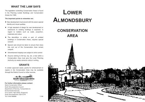
WHAT THE LAW SAYS<br />
The legislation controlling Conservation Areas is found<br />
in the Planning (Listed Buildings and Conservation<br />
Areas) Act 1990.<br />
The important points to remember are:<br />
New development must accord with the <strong>area</strong>’s special<br />
identity and visual qualities.<br />
A high standard of design for new development or<br />
extensions to existing buildings is expected, in<br />
regard to matters such as scale, proportion,<br />
materials and colour.<br />
The demolition, in whole or part, of unlisted<br />
buildings in Conservation Areas, requires special<br />
consent.<br />
LOWER<br />
ALMONDSBURY<br />
CONSERVATION<br />
AREA<br />
Special care should be taken to ensure that views<br />
into and out of the Conservation Area remain<br />
unspoilt.<br />
Advertisement displays are subject to strict control.<br />
Anyone wishing to fell top, lop, etc. a tree within a<br />
Conservation Area must give the Local Planning<br />
Authority six weeks advance notice in writing.<br />
GRANTS<br />
In certain approved cases, grants for enhancement or<br />
repairs in the Conservation Area may be available<br />
through the District Council or other sources.<br />
For further information please contact:<br />
Senior Conservation Officer<br />
<strong>South</strong> <strong>Gloucestershire</strong> Council<br />
Department of Planning, Transportation &<br />
Environmental Services,<br />
Civic Centre, High Street, Kingswood,<br />
<strong>South</strong> <strong>Gloucestershire</strong> BD15 2TR<br />
Tel: 01454 868686 11/96
LOWER ALMONDSBURY CONSERVATION AREA<br />
North<br />
POLICY<br />
OBJECTIVES FOR<br />
ENHANCEMENT<br />
The following objectives are set out in the<br />
Rural Areas Local Plan:-<br />
To preserve individual buildings, groups of<br />
buildings, walls, open <strong>area</strong>s, natural features<br />
and trees and to retain the essential<br />
interrelationships upon which the character of<br />
the Conservation Area depends.<br />
Development should preserve or enhance the<br />
existing character of Conservation Areas.<br />
Large scale or comprehensive development<br />
schemes will not normally be permitted. The<br />
emphasis will be on the selective renewal of<br />
individual buildings.<br />
Conservation Area<br />
Designated 30th.July 1975<br />
Listed Buildings<br />
Reproduced from the Ordnance Survey map with the permission of the<br />
Controller H.M.Stationery Office. Crown Copyright Reserved.<br />
<strong>South</strong> <strong>Gloucestershire</strong> Council Licence No. 100023410/05<br />
Leaflet produced by <strong>South</strong> <strong>Gloucestershire</strong> Council<br />
Printed on Environment friendly Paper
CHARACTER<br />
The village of <strong>Lower</strong> <strong>Almondsbury</strong> nestles below<br />
the steep wooded <strong>Almondsbury</strong> Hill which shelters<br />
and largely obscures the village from above.This<br />
landscape feature provides an attractive backcloth<br />
to the village and contributes significantly to<br />
<strong>Almondsbury</strong>’s character. The woodland is<br />
protected by a Tree Preservation Order. The top of<br />
this hill provides a superb vantage point with views<br />
across the Severn where both bridges are clearly<br />
visible.<br />
SETTING<br />
The village of <strong>Almondsbury</strong> is situated 7 miles<br />
north of Bristol, near the M4/M5 <strong>Almondsbury</strong><br />
Interchange, the first four-level motorway crossing<br />
in Britain. <strong>Almondsbury</strong> lies within the Bristol & Bath<br />
Green Belt. The village falls into two distinct parts<br />
divided by the A38, with modern ribbon<br />
development to the east and the old nucleus of<br />
<strong>Lower</strong> <strong>Almondsbury</strong> clustering beneath the steep<br />
and wooded <strong>Almondsbury</strong> Hill.<br />
If one enters the village via Sundays Hill or Hollow<br />
Road the steep and wooded descent is attractive<br />
and enclosed, gradually opening up by The Forge.<br />
St Marys Church dominates the village from its<br />
position at the foot of the escarpment and its<br />
splendid spire rises up revealing its position from<br />
the ridge.The small but picturesque village green<br />
with pump in the foreground of the church<br />
provides a typical village scene, enhanced by<br />
cottages of local stone nearby.<strong>Almondsbury</strong><br />
village is rich in variety and style, with stone walls<br />
lining the narrow roads which are especially<br />
attractive in the spring and summer being covered<br />
in overhanging vegetation and blooms.<br />
St Mary’s and beyond<br />
Spectacular views across the Severn Estuary are<br />
afforded on the descent from new to old<br />
<strong>Almondsbury</strong>.
HISTORY<br />
<strong>Almondsbury</strong> was originally, as its name implies,<br />
the ‘Bury’ or camp of Alomond, a Saxon chieftain.<br />
The steep limestone scarp would have provided<br />
an excellent defensive site and signs of<br />
entrenchment can still be seen. <strong>Almondsbury</strong> Hill<br />
is a vantage point affording superb views across<br />
the Severn Valley to the Welsh Hills beyond.<br />
The original manor house was at Court Farm<br />
(grade II listed) in <strong>Almondsbury</strong> village but Chester<br />
chose the splendid hilltop position half a mile to<br />
the south with a magnificent view over the Bristol<br />
Channel for construction. A 15th century<br />
octagonal tower on this site was retained and<br />
incorporated into the house. Unfortunately, all that<br />
remains of the original house is the tower, reduced<br />
in size and incorporated into a modern dwelling.<br />
Old Pound<br />
Court Farm<br />
Medieval <strong>Almondsbury</strong> lay on the main route<br />
between Bristol and Gloucester and a market was<br />
established in 1285. For centuries, <strong>Almondsbury</strong><br />
was a close-knit agricultural community under the<br />
patronage of its great manor houses of Knole<br />
Park, Over Court and Gaunts Earthcott. The<br />
Manor of <strong>Almondsbury</strong> belonged to St Augustine’s<br />
Abbey in Bristol until the dissolution and was<br />
granted to Sir Arthur d’Arcy in 1553. It was sold to<br />
Thomas Chester in 1569 and his heir, William<br />
Chester built Knole Park as a family seat.<br />
Over Court, an Elizabethan Manor house 2 miles<br />
south west of <strong>Almondsbury</strong>, built about the same<br />
time as Knole Park on the site of a 14th century<br />
house has also sadly been demolished, again to<br />
be replaced by new housing development.<br />
The church of St Mary (grade I listed) is said to<br />
have been consecrated by four bishops in 1148. In<br />
the mid-13th century there was considerable<br />
rebuilding when the chancel, crossing and<br />
transept were reconstructed. The church was<br />
heavily restored in the 19th century and the most<br />
notable features are its Norman north porch and<br />
font and its elegant, distinctive diagonally<br />
patterned lead spire, one of only three in the<br />
country